1" snow Wednesday.
3.2" so far in March.
9" on the ground at MSP Wednesday evening (that may shrink down to 2-3" by next Thursday).
118 days in a row with at least 1" of snow on the ground in the metro area.
99 number of days last winter with an inch or more of snow on the ground.
136 number of days with continuous snowcover (1" or more) during the winter of 1964-65 (most since 1916)
Data from the MN State Climate Office (thanks to Greg Spoden)
* 40s and 50s next week will accelerate snow melt and the risk of river flooding statewide.

On this blog I've been posting the latest model predictions looking out a week or more, knowing full well that some of these long-range guestimates are iffy. I went out of my way to remind (everyone) that confidence levels were low, I tried to explain, "here's what the models are saying." "Here's a look into the future, warts and all." Maybe that's the wrong approach. I'm starting to wonder if I should do a better job of editing the models and not putting everything out there. Long range forecasting is the meteorological equivalent of making sausage - you probably don't want to see the process, if you can help it. Dozens of models to choose from, some work better than others in certain scenarios, sometimes they all disagree. On occasion they're all wrong - which was pretty much the case with this last "storm".
I suspect that the physics in the models (especially the GFS, which is the only American model that goes out beyond 84 hours) has a tougher time dealing with the transition from a wintry regime to a springlike pattern, which is what's underway right now. I can't prove that, but I've heard enough complaining (from other meteorologists) that leads me to believe that a March model run is probably more unreliable than a January model solution. I did try to give a blow by blow account of what the models were predicting (for better or worse), and a few days ago it really did look like we could be in for a major snowfall. But since Monday the models (including the GFS and the NAM/WRF) began to pull back, pushing the track farther east, and we gradually dropped our predictions, to the point we were calling for "an inch or two" as of Tuesday. No excuses - this last system was not handled well. It's easy to blame the models, but it's our responsibilty as meteorologists to monitor and vet those models, throw out the dubious model runs - and through a combination of gut feel, historical context and experience zero in on the right solution, weeding out the "correct" model. The GFS nailed the major snowstorms back in December and February (which probably gave me a false sense of security and confidence). This time around the models were almost worthless. So I'm wrestling with this: do I continue to post what the models are predicting (come what may), or do more judicious editing, and only post what I think may REALLY unfold looking out 5-15 days? My gut is telling me to still share as much (raw data) as possible - get it out there and let you see what the guidance is saying, but do a better job of attaching a "confidence level" to those models. When all the models agree our confidence tends to go up, and for a time late last week all the models were hinting at over 6", maybe a foot for parts of southeastern MN. They were (all) wrong, in 20/20 hindsight. That's what's so frustrating about this last system.
A humbling profession, yes. Mea culpa and all due apologies to snow-lovers. Time to go back to eating my crow souffle. Very tasty.

Snowy Marathon. According to Greg Spoden over at the MN State Climate Office, today will be the 119th consecutive day with 1" or more of snow on the ground. Last winter we only had 99 days with snowcover. The all-time record: 136 days/row, set back in the winter of 1964-65. I don't think we'll go that long, but 120 days seems pretty likely, in spite of next week's (major) thaw. More details:
MINNEAPOLIS/ST PAUL, MN
Threshold Search for Runs of Special Events
Years: 1891 To 2011
(Conditions are : Snow Depth (in) Greater Than Or Equal To 1.0) (Minimum Days in the run : 100)
Time Period No. of Days
1916-12-15 to 1917-03-28 104
1919-11-27 to 1920-03-14 109
1942-11-25 to 1943-03-13 109
1950-11-22 to 1951-04-04 134
1951-12-17 to 1952-03-30 105
1952-11-25 to 1953-03-18 114
1954-11-27 to 1955-03-12 106
1955-11-28 to 1956-03-21 115
1961-12-09 to 1962-03-30 112
1964-11-26 to 1965-04-10 136
1969-12-07 to 1970-03-25 109
1970-12-11 to 1971-03-27 107
1971-11-23 to 1972-03-18 117
1975-01-03 to 1975-04-13 101
1978-11-17 to 1979-03-22 126
1981-11-19 to 1982-03-28 130
1985-11-22 to 1986-03-24 123
1991-11-23 to 1992-03-01 100
1995-11-27 to 1996-03-11 106
1996-11-20 to 1997-03-21 122
2000-12-24 to 2001-04-04 102 * Chanhassen - National Weather Service Forecast Office (no snow data gathered at MSP)
2007-12-02 to 2008-03-12 102
2010-12-01 to 2011-03-09 99 * MSP
2010-11-13 to 2011-03-09 117 * Chanhassen - National Weather Service Forecast Office
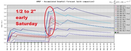
Dribs and Drabs of Snow. No big systems brewing, but an eastbound clipper may squeeze out a quick inch of slush Saturday morning, maybe 2" in a few towns. Whatever falls will be gone by Saturday afternoon, the sun now as high in the sky as it was the last week of September.
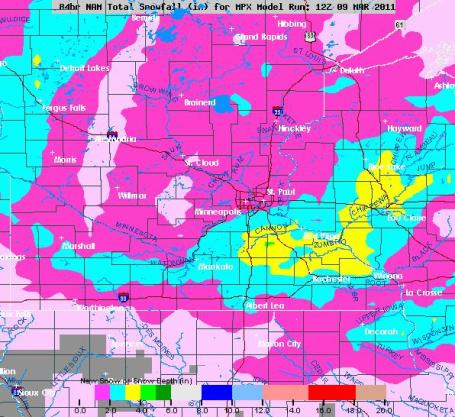
Saturday Slush. The NAM/WRF model prints out an inch, maybe 2" just south/east of St. Paul. Precipitation should start out as rain Friday night, changing to wet snow early Saturday as the entire column of the atmosphere overhead begins to cool.
Friday Clipper. Enough mild air should flow north ahead of Friday's clipper for low 40s, insuring rain showers Friday evening/night. A changeover to wet snow is possible late Friday night into Saturday morning, but this should be more of a nuisance event than a plowable snowfall.
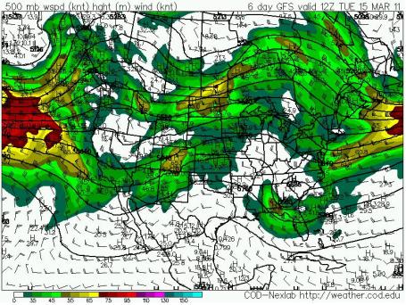
Shifting Winds. 500 mb winds (about 18,000 feet aloft) are becoming more zonal, the incredibly persistent blocking pattern triggered by the NAO, the North American Oscillation, finally breaking down, allowing a persistent (mild) flow from the Pacific, instead of the Yukon. The result will be a rapid thaw. A worst case scenario for flooding would be 40s and 50s with heavy rain. Mercifully, I don't see any heavy rain looking out the next 1-2 weeks.
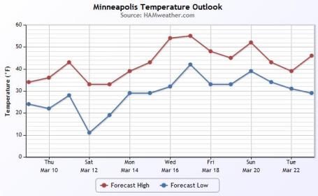
Warming Trend. Forget March, by early next week it should feel more like April: 40s, even a few days in the low 50s. Hard to believe we saw -3 F. in the metro 8 days ago.
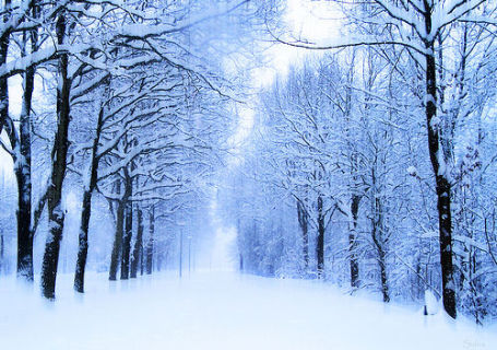
Deja vu All Over Again. March of 2010 we saw 60s by mid-month. It won't warm up quite that fast (too much snow to melt - the sun's energy will go into melting snow, instead of warming up the air), but the GFS is suggesting highs near 60 by March 21. We'll see. Bottom line: our 9" of snow on the ground will shrink to 3 or 4" within a week.

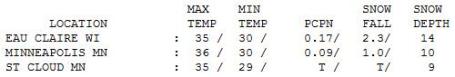

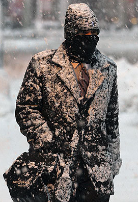
Wednesday Slush. An inch of snow fell (officially) at MSP yesterday, with 2" at Jordan, a whopping 4" in Ellendale. Eau Claire picked up 2.3" of snow, with some 6-8" over central Wisconsin. Highs statewide were in the mid 30s, pretty close to average for this date.
Paul's Conservation MN Outlook for the Twin Cities and all of Minnesota:
TODAY: Sun returns, hints of spring. W 5-10 High: 38
THURSDAY NIGHT: Mostly cloudy. Low: 22
FRIDAY: Clouds increase, rain showers late High: 42
FRIDAY NIGHT: Rain changes to wet snow late. Low: 29
SATURDAY: 1-2" slush early, slow PM clearing. High: 33
SUNDAY: Intervals of sun, quiet weather. Low: 17. High: 34
MONDAY: Clouds increase, turning milder. Low: 25 High: 42
TUESDAY: Cloudy and milder, PM rain showers? High: 47
WEDNESDAY: Some sun, feels like March! High: 45
Cringe-Worthy Stats
A few nuggets of weather lore you won't hear from the local Chamber of Commerce. 1). July is the only month where snow hasn't been reported somewhere in Minnesota. A gasp-worthy statistic, yes. 2). Today is the 118th day/row with at least 1" or more of snow on the ground in the Twin Cities, according to Greg Spoden at the State Climate Office. We've had snow on the ground since November 23. Last winter (99 days/row of snow) we had lost our last inch by now, with 60s by mid-March! At the rate we're going this year we may wind up with 130-135 days/row with continuous snow cover; the most since 1981 (130), possibly 1961 (136 days/row).
A transition from winter to a more springlike pattern has taken a toll on the weather models (and meteorologists). Exhibit A: yesterday's fizzling "storm". Ugh.
The sun returns today, the atmosphere mild enough for some rain (there's a new word) late Friday, possibly ending as 1-2" slush Saturday morning. No mega-storms are brewing through the end of next week; just a warming trend. That's right, a string of 40s next week as the Big Melt begins. If you live near a stream or river you should draft an action plan.
Check your flood insurance policy.

Americans Believe In Climate Change More Than "Global Warming". O.K. In the end it all comes down to semantics. They are different expressions for the same phenomenon: shifting climate patterns (and more extreme weather) brought on by a slow warming trend, most pronounced at higher latitudes. But words matter, according to a story at treehugger.com: "Would an environmental disaster by another name be taken more seriously? Apparently the answer is yes. New research shows that Americans are more likely to be skeptical about 'global warming' than about 'climate change'. I think many people have intuitively known this for some time, but a study coming out of the University of Michigan, to be published in Public Opinion Quarterly, gives us some stats on how important language can be on this issue.Of the 2,000-something US adults surveyed, 74% of people thought the issue was real when it was referred to as 'climate change', but that drops to 68% when it's termed 'global warming'. Perhaps not a huge difference, but significant. Breaking that down on US political party lines, 60% of Republicans thought that climate change was real versus 44% for global warming. For Democrats, 86% though that climate change was a serious problem regardless of wording."
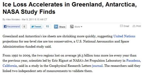
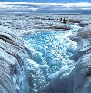
Ice Loss Increases In Antarctic, Greenland, NASA Study Finds. Bloomberg has an update on troubling changes taking place in Greenland and Antarctic - happening faster than supercomputer simulations were predicting 5-10 years ago: "Greenland and Antarctica’s ice sheets are shrinking more quickly, suggesting United Nations projections for sea-level rise are too conservative, a U.S. National Aeronautics and Space Administration-funded study said. From 1992 to 2009, the two regions lost on average 36.3 billion tons more ice every year than the previous year, scientists led by Eric Rignot at NASA’s Jet Propulsion Laboratory in Pasadena, California, said in a study in the Geophysical Research Letters journal. The researchers said they linked two independent sets of measurements to validate them. Continuing the trend may raise oceans 15 centimeters (6 inches) from 2010 to 2050, and by 56 centimeters by 2100, the study said. That’s more than what was factored into the 2007 projection by the UN’s Intergovernmental Panel on Climate Change for seas to rise 18 to 59 centimeters by 2100. “If present trends continue, sea level is likely to be significantly higher than levels projected by the United Nations,” Rignot said in a statement e-mailed late yesterday by NASA. “Our study helps reduce uncertainties.”

Canadians Want Urgent Action On Climate Change More Than Ever Before. An update from marketwire.com: "TORONTO, ONTARIO--(Marketwire - March 9, 2011) - A poll conducted on behalf of WWF has found that Canadians are increasingly convinced about the need for urgent action on climate change. WWF's year-over-year data shows that 84 per cent of Canadians are as convinced or more convinced than last year that urgent action is necessary. At its core, climate change is about energy: how we produce it and how we use it. Switching from non-renewable to renewable energy, coupled with energy efficiency and conservation, is the only effective solution to climate change. Currently, Canada is one of the top 10 nations contributing to global climate change, but we don't have to be. WWF asks Canadians to show their support for clean energy as the solution to climate change by participating in WWF's Earth Hour. Last year 50 per cent of Canadians participated. This year join over a billion people worldwide and switch off your lights on Saturday, March 26 from 8:30 - 9:30 p.m."
Paul, thanks for this post. I think keeping the data raw is the way to go. Most people can live with the models being wrong (occasionaly). Some of the headlines that predict 12" of snow - that is what ends up sticking in peoples heads. You also probably have a very diverse following - from other on-air mets, to kids in school, all with varrying degrees of knowledge and expectations. Following up a missed forecast with an explanation like you did here definately helps - at least in my opinion. Part of it just may be that we all get excited when it looks like a storm is on the way. It then becomes a little more disappointing when it doesn't materilize. Luckily - the weather moves on not letting us dwell too much on the past.
ReplyDelete