84.7" snow so far in the Twin Cities.
82.7" seasonal snowfall in Duluth.
78.2" seasonal snowfall at International Falls.
* Rain later today and tonight, another (heavier) rain event Sunday, possibly ending as a rain/snow mix on Monday.
* Highs near 50 Saturday (dry for Conservation Minnesota bike ride, part of the St. Paul Legacy Weekend) - string of 50s possible the end of next week.
Date of Last Reported Snow in the Twin Cities (trace or more).
2011: ???
2010: Feb. 23
2009: April 5
2008: April 27
2007: April 12
2006: March 24
2005: May 2
Fargo Flood Update. Click
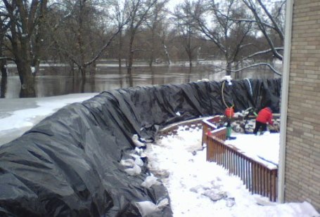
here for more resources focused on impending flooding in the Fargo/Moorhead area. Warnings are now in effect for an ultimate crest on the Red River that may not come until the latter half of April. Over 5 million sandbags are being deployed - local residents holding their breath that flooding will not rival the record levels of 1997.
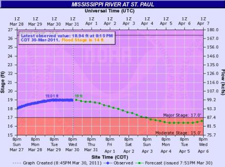
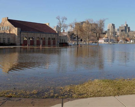
Good (Short-Term) News For St. Paul. Water levels on the Mississippi River in St. Paul are falling now, after cresting close to 19 feet. NOAA forecasters warn of additional crests later in April, possibly even the first half of May, as snow over the Mississippi headwaters begins to melt. The rate of melting (and any heavy rain) will determine the extent of any future flooding. The latest flood forecast for St. Paul is
here.
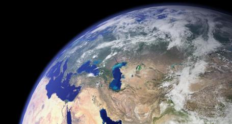
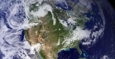
High-Res Earth. These new satellite images are from a new Russian weather satellite - click
here for the full-res image of North America, Asia can be found
here - courtesy of gizmodo.com.
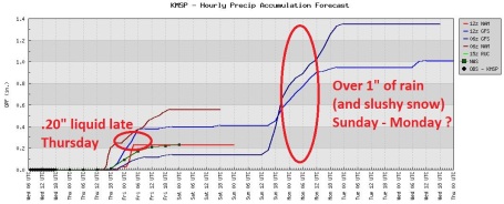
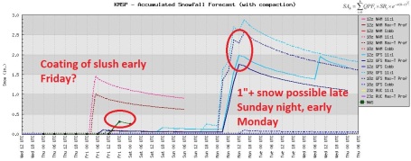
Two Slushy Encounters. Although most of today's precipitation will fall as rain, we can't rule out a period of wet snow across central Minnesota, even the far northern suburbs of the Twin Cities by tonight. With temperatures generally above freezing most roads will probably stay wet, but slush may pile up on lawns and fields. A more substantial surge of moisture from the Gulf of Mexico (over half an inch?) arrives Sunday, possibly ending as a rain/snow mix on Monday. Once again most roads will be wet, but an inch or two of slush may pile up on fields (and slow-moving robins) across central Minnesota on Monday at the tail-end of this system.
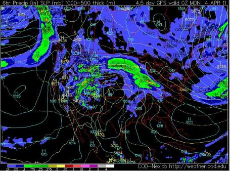
Cold Rain on Sunday. The predicted surface map (6 pm Sunday) shows an area of low pressure over western Kansas, an extensive shield of rain stretching from the Dakotas across Minnesota to Chicago. Although the bulk of the precipitation should fall as a cold rain, winds shifting around to the north Sunday night and Monday should spark a changeover to a rain/snow mix, then all-snow, with a potential for a "couple inches" over parts of central Minnesota. Whatever falls should be gone by Tuesday afternoon; with a sun angle as high in the sky as it was during the 1st week of September it'll be hard to keep any (new) snow around for long.
Late Season Nor'easter. While a weak disturbance (a wrinkle of unusually cold air aloft) squeezes out a few tenths of an inch of rain (and wet snow) on our heads tonight, the main action will be taking place along the east coast, as a late-season coastal storm flings Atlantic moisture inland, putting down some heavy snow and ice amounts across the northeast. Air travel from Albany to Boston may be impacted by Friday - I do expect delays and some cancellations.
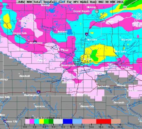
Projected Snowfall. The NAM solution, valid through midday Saturday, shows a sloppy inch of slush for the suburbs of the Twin Cities (north metro - tonight), while New England gets battered by as much as 5-10" of heavy, wet snow. Don't let anyone living in Boston give you a hard time about a Minnesota spring.
Slushy Possibilities. The NAM model is predicting a coating to an inch or so of slush - possibly 2" east metro (mainly lawns and fields Thursday night), as much as 2-4" possible north/east of St. Paul.
Nuisance Snow. It looks like little more than slushy coating late tonight and early Friday - Sunday's rain may end as a rain/snow mix early Monday, with a potential for a slushy inch or so close to home.
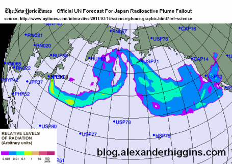
Fears Of Fallout: Radiation Concerns Rise, But Mostly Unfounded. There is a definite level of paranoia out there about radiation levels (do we have to worry about the rain being radioactive?) The East Otter Tail Focus takes a look at radiation levels in Minnesota in a rather reassuring
story: "
The recent news emanating from Japan about radioactive fallout drifting from a stricken nuclear power complex is a reminder that radiation can pose a health risk. Last week, for instance, the Food and Drug Administration banned imports of milk, fresh fruit and vegetables from the area of Japan exposed to fallout in the aftermath of the catastrophic earthquake and tsunami. Worries about possible exposure to fallout, in fact, drifted thousands of miles to North Dakota, where some called state health officials to ask whether they should take potassium iodide tablets as a precaution against contamination. Quick answer: No. The amounts of radioactivity that reached the United States are minuscule and pose no health risk, officials say. But radiation is all around us in very small doses. It bombards our bodies through cosmic rays; it’s emitted from minerals in the soil; it’s even present in some of the foods we eat – in infinitesimal amounts. The natural radiation we’re exposed to in our everyday lives is called background radiation. Worldwide, the average dose of radiation from natural sources is 2.4 to 2.8 millisieverts, a measuring unit of very small levels of radioactivity. Roughly half of that amount comes from inhalation, mainly radon gas, a product of decaying uranium contained in rocks and soils. Background radiation is a bit higher around Fargo-Moorhead, at about 3 millisieverts, according to Brent Colby, a radiology physicist for Sanford Health in Fargo. That’s likely because radon levels across all of North Dakota and much of western Minnesota are higher than many areas, according to the Environmental Protection Agency."
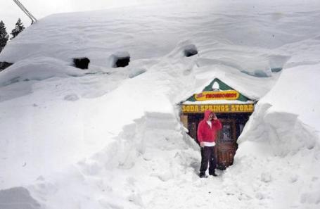
Governor Expected To Declare California's Drought Over. No kidding. They've been counting snow not by the inch but by the foot in recent months. Over 600" of snow for some of the ski resorts near Lake Tahoe. The L.A. Times has an
update: "
Gov. Jerry Brown is about to make official what a winter of downpours and rising reservoir levels have already made obvious: California's drought is over. Brown is expected to lift the state's 3-year-old drought declaration Wednesday, when the next snow survey is conducted. In a statement released Monday, the governor's office said it "is waiting for the season's final snow survey later this week to officially rescind the previous administration's drought declaration. While this season's surplus of rain and strong snowpack has clearly ended the dry spell for now, it is critical that Californians continue to conserve water." The drought ended from a hydrological perspective last year, but state officials said they were not ready to declare it over because reservoir storage had not fully recovered and this year might turn dry. It has been anything but. Dam operators have been ramping up releases from the state's reservoirs this month, water managers have repeatedly upped projections of summer deliveries, and as of Friday, the all-important Sierra Nevada snowpack was 159% of normal for this time of year."
Near-Record Sierra Snow Good News For Parched California. Another article, this one from
TheNewsTribune.com: "
After state water officials release the results of their latest snow survey Wednesday afternoon, Gov. Jerry Brown is expected to officially declare the drought over, said Evan Westrup, a spokesman for the governor's office. Former Gov. Arnold Schwarzenegger declared a statewide drought in June 2008 and a state of emergency because of low water levels in February 2009. The accumulations are measured two ways: current snow on the ground and accumulated snow for the season, which began with the first storms last fall. More than 61 feet of snow has fallen in the Sierra high country so far this season, second only to the 1950-51 season when a total of 65 feet fell, according to records kept by the California Department of Transportation. While spring has arrived, the Sierra typically gets some snow in April, bringing the prospect of an all-time record."
For The Southwest: Torrents Of Water, And A Parched Fate. Here's a
story that ran in Wednesday's Wall Street Journal (subscription may be required to view the full text of the article): "
BOULDER CITY, Nev.—For the 30 million Americans who depend on the Colorado River for their water, this past winter's soaking rains and snows will only leave them thirsting for more. Water managers warn that Lake Mead, the West's largest and most important reservoir, remains perilously near the level of 1,075 feet at which the U.S. Secretary of the Interior would likely declare a water shortage, for the first time in the nearly century-old history of the Colorado River system. Such a shortage would parch Nevada, Arizona and California with severe water-use restrictions. There alone, some 20 million people depend on Lake Mead's supplies. The fierce winter did bring some good news. The vast lake is rising for only the second time since the Southwest entered a debilitating drought 12 years ago. The water is 14 feet higher so far, and is projected to rise about nine feet more from the spring's snowmelt by the end of the current water year in September. That takes into account the expected drawdown. But even these fresh torrents are nowhere near enough to make up for the dozen-year deficit. The metropolitan areas that rely on Lake Mead, including Los Angeles, Las Vegas and Phoenix, remain at risk for shortages and severe water restrictions in the coming decades, as the Southwest—like many arid parts of the world—struggles to balance rapid growth with tight water supplies."
Warm Water Causes Extra Cold Winters in Northeastern North America and Northeastern Asia. How can an unusually warm waters in the Gulf Stream result in an atmospheric domino-effect that pushes colder air into much of northeastern North America? The answer: Rossby waves. Caltech has an
explanation here: "This image, taken by NASA's Terra satellite in March 2003, shows a much colder North America than Europe—even at equal latitudes. White represents areas with more than 50 percent snow cover. NASA's Aqua satellite also measured water temperatures. Water between 0 and -15 degrees Celsius is in pink, while water between -15 and -28 degrees Celsius is in purple." [Credit: NASA/Goddard Space Flight Center Scientific Visualization Studio; George Riggs (NASA/SSAI)]
"
PASADENA, Calif.—If you're sitting on a bench in New York City's Central Park in winter, you're probably freezing. After all, the average temperature in January is 32 degrees Fahrenheit. But if you were just across the pond in Porto, Portugal, which shares New York's latitude, you'd be much warmer—the average temperature is a balmy 48 degrees Fahrenheit Throughout northern Europe, average winter temperatures are at least 10 degrees Fahrenheit warmer than similar latitudes on the northeastern coast of the United States and the eastern coast of Canada. The same phenomenon happens over the Pacific, where winters on the northeastern coast of Asia are colder than in the Pacific Northwest. Researchers at the California Institute of Technology (Caltech) have now found a mechanism that helps explain these chillier winters—and the culprit is warm water off the eastern coasts of these continents."
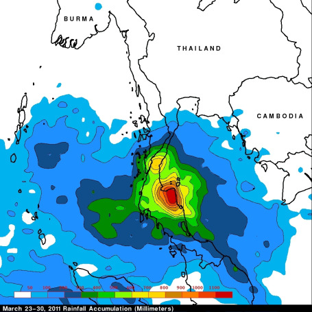 NASA's TRMM Satellite Sees Deadly Rainfall Over Thailand.
 Here's another example of how "remote sensing", in this low-orbit satellites, are making a huge difference spotting major weather events in areas where surface data (airport observations) are relatively sparse and unreliable. Here's a recent
story from NASA: "
Data from NASA's Tropical Rainfall Measuring Mission or TRMM satellite was used to create a rainfall map of the severe rains that fell in Thailand recently. More than 20 people have been killed in southern Thailand over the past week due to flooding and mudslides caused by extremely heavy rainfall. TRMM is a satellite managed by both NASA and the Japanese Space Agency, JAXA. It is a unique satellite because its advanced technology enables it to measure rainfall from space. A Multi-satellite Precipitation Analysis (TMPA) analysis was made using data that were calibrated with TRMM precipitation data. These data are calculated and stored at NASA's Goddard Space Flight Center in Greenbelt, Md. and are available within a few hours after being received by satellites. The analysis showed that rainfall for the past week over the Malay Peninsula was particularly extreme with totals of almost 1200 mm (~47 inches)."
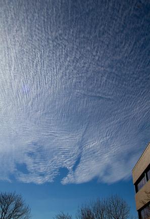
A Cloud To Remember - A Mystery To Solve. UCAR's Margaret LeMone has an intriguing
article about a mystery-cloud that formed directly over the research facility in Boulder, Colorado. More details from NCAR/UCAR's "Currents": "
Walking out of the NCAR Foothills Lab last Wednesday, 23 March, at 3:15 p.m. MDT, I was stopped in my tracks by an incredible sky: a high, very thin layer of small, uniform, tiny cloudlets. Since each of the cloudlets was less than a degree wide and unshaded, the cloud formation fits the World Meteorological Organization definition of cirrocumulus. But was it? To the southwest, smoke from a fire to the west of Golden was marked by a wavy structure in the air at lower levels, which often happens here in Colorado. Jets flying overhead left intermittent contrails west of the cloud edge, as well as paths of clear sky in the cloud layer called “distrails” (these are also called “canals” at a later point in their evolution). There were even a few fair-weather cumulus clouds, forerunners of more spring-like weather. All in one sky! What caused all of this?"
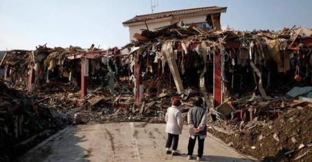
Confidence Slips Away As Japan Battles Nuclear Peril. Just when you thought it was safe to turn on your TV again (or pick up a newspaper). The
latest on the slow-motion horror story unfolding northeast of Tokyo from the New York Times: "
TOKYO — After workers switched on the first set of control room lights at Japan’s crippled power plant in Fukushima last week, the Japanese government offered its strongest assurances yet that its nuclear crisis was close to being under control. Heroic workers and firefighters continued to cool the volatile reactors by pumping in hundreds of tons of water a day. Much-awaited electricity had reached the plant after a rush to extend new power lines, ready to hook up to vital cooling systems and guide the plant to a long-term “cold shutdown.” But less than a week later, a deluge of contaminated water, plutonium traces in the soil and an increasingly hazardous environment for workers at the plant have forced government officials to confront the reality that the emergency measures they have taken to keep nuclear fuel cool are producing increasingly dangerous side effects. And the prospect of restoring automatic cooling systems anytime soon is fading. The recent flow of bad news from the Fukushima Daiichi Nuclear Power Station has undermined the drumbeat of optimistic statements by government and company officials who have at times tried to reassure a nervous public that significant progress is at hand — only to come up short."
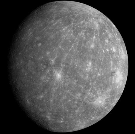
NASA Probe Goes Into Mercury's Orbit. An update from Ira Flatow of
Science Friday: "
NASA's Messenger Probe has been taking measurements of the planet Mercury since 2004. On Thursday it slowed itself down enough to enter an elliptical orbit around Mercury to look at the planet's atmosphere and geology. Principal investigator for the mission Sean Solomon discusses what the team hopes to find."
Amazon To Apple: It's Sooo On!!! In geek news of the day, this
post comes from Andy Ihnatko's Celestial Waste of Bandwidth: "
This is why I love my job. Today, Amazon enabled two new features to their site: Amazon Cloud Player and Amazon Cloud Drive. Cloud Drive is iDisk via Amazon storage, pretty much. You get 5 gigs of storage for free and can buy more as you need it. Your Cloud Drive can store anything…documents, photos, movies, music. Cloud Player…lets you stream all of the music you’ve stored on your Cloud Drive. Annnnd everything you purchase via Amazon MP3 (from now on, anyway) is automatically added to your Cloud Drive and doesn’t count towards your storage limit. If you buy 100 gigs of Amazon MP3, you can play all of it for free without paying a dime. In fact, if you buy MP3s from Amazon, they’ll up your “regular” storage to 20 gigs anyway. And there’s a helper app that’ll scan your existing iTunes library for music files that are compatible with the service. Click a button and all of it — or selected playlists — get uploaded to your Cloud Drive…even files you didn’t purchase through Amazon MP3."
Buy an MP3 album—get 20 GB of storage free for a year
Purchase an album from the Amazon MP3 Store and we'll give you 20 GB of storage free of charge for one year from the date of your purchase. That's enough space to store up to 4000 songs. You can keep your 20 GB storage plan after the year is up or do nothing and we'll drop you down to our free 5 GB plan. Don't worry—you will never be charged for storage space unless you choose to upgrade to a paid storage plan.
Learn more about the 20 GB promotion from Amazon.
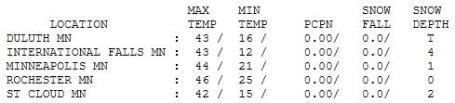
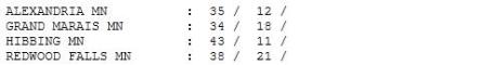
Moving In The Right Direction. Still 5 degrees or so below average, Wednesday felt a bit more like spring with blue sky and relatively light winds, highs ranging from 34 at Grand Marais to 42 in St. Cloud, 44 in the Twin Cities.
Paul's Conservation MN Outlook for the Twin Cities and all of Minnesota:
TODAY: Cloudy, rain develops this afternoon/evening. Winds: S 10-15. High: 46
THURSDAY NIGHT: Rain mixes with wet snow. Most roads stay wet (coating - 1" slush northern suburbs?) Low: 36
FRIDAY: Slushy mix tapers off , clouds linger. High: 47
SATURDAY: Partly sunny, hints of spring in the air. Low: 32. High: near 50
SUNDAY: Rain arrives, possibly heavy. Low: 34. High: 45
MONDAY: Rain/snow mix. Mainly wet roads. Low: 35. High: 42
TUESDAY: Blue sky returns, little snow left. Low: 29. High: 48
WEDNESDAY: Clouds increase, milder. Low: 34. High: 52
Head-Shaking Winter
At 84.7", the Twin Cities have picked up more snow this winter season than Duluth (82.7") and International Falls (78.2"). That doesn't happen very often. Hutchinson has been buried under 99" of snow. With frozen (saturated) soil and as much as 4-7" liquid water trapped in the 15-22" snow still on the ground over much of western and northern Minnesota, you can understand why river forecasters are losing sleep.
Flood warnings are posted for the Fargo/Moorhead area, for a crest that may not come 'til the 3rd week of April. Let's hope the 5 million sand bags keep the water within its banks.
50 will feel remarkably good by Saturday; no sudden 60s or 70s in sight. The greater wild card is precipitation: especially rain, which would melt snow (faster), increasing the rate of run-off into Minnesota's streams and rivers.
The lowest mile of the atmosphere should be (just) warm enough for rain in the metro later today, a couple inches of slush possible from central MN to Duluth. We get a break on Saturday, before a southern storm drops .50"+ rain Sunday, possibly ending as a rain/snow mix Monday. Much of the dirty snow in your yard will be gone by next week. Gone, but not forgotten.
Did Obama Administration Play Favorites With Energy Loans? A story from ABC News: "
When the White House announced the federal government would loan $465 million to Tesla, a California start-up company with plans to develop an all-electric sedan, President Obama called it an "historic opportunity to ensure that the next generation of fuel-efficient cars and trucks are made in America." The loan also represented a lucrative opportunity for Steve Westly, a major investor in the car company who had raised more than $500,000 for the president's campaign. In 2009, the U.S. Department of Energy lent more than half a billion dollars to companies backed by Westly's California venture capital firm. In 2010, the White House tapped Westly for a seat on a special energy advisory panel that gives him regular access to Energy Secretary Steven Chu. Westly boasts on his website that his firm is "uniquely positioned" to take advantage of the Obama administration's interest in green energy."


No comments:
Post a Comment