42 F. high in the Twin Cities Tuesday.
47 F. average high for March 29
59 F. high temperatures on March 29, 2010.
83 F. record high (March 29, 1986).
*
Probably mild enough aloft for rain late Thursday and Thursday night in the Twin Cities (couple inches of slush possible far northern suburbs to Duluth).
*
Saturday: still the sunnier, drier, nicer day - shot at low 50s.
*
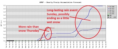
Models hinting at a half inch of rain Sunday and Monday, possibly ending as wet snow up north.
*
Dry much of next week - string of 50s possible
as we turn the corner into a more springlike pattern. Cue "Hallelujah Chorus".
*
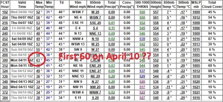
First 60 on or around April 10? The GFS says so - we'll see. The maps are
finally starting to look a bit more springlike.
Going Fast. Here is the Tuesday "
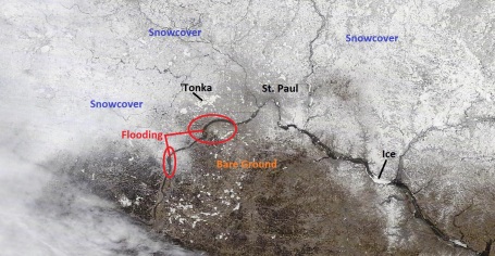
MODIS" satellite image from NASA's low-orbiting Terra craft, which passed a little more than 200 miles above the Twin Cities yesterday. It shows a fair amount of bare (snowless) ground over the south metro, still ample snow over the western, northern and eastern suburbs of the Twin Cities. Ice dams show up on the Mississippi - look carefully and you can see the Minnesota River spilling over its banks between Mankato and Jordan.
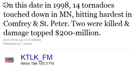
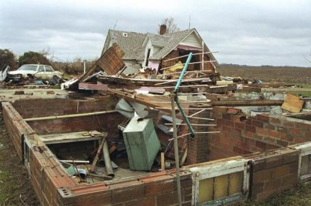
Dark Anniversary. On March 29, 1998 a swarm of large, violent, long-lasting tornadoes ripped across southern Minnesota; EF-4 strength tornadoes observed at Comfrey, EF-3 at St. Peter, with extensive damage reported to the Gustavus Adolphus campus. It was a vivid reminder that tornado season in Minnesota runs from mid March through mid October. More from
Wikipedia on the outbreak: "
The 1998 Comfrey – St. Peter tornado outbreak was an unseasonably-strong tornado outbreak which affected the Upper Midwest region of the United States on March 29, 1998. A strong area of low pressure combined with a warm front and favorable upper-leveldynamics to produce 16 tornadoes across the region—14 in Minnesota and two in Wisconsin. Thirteen of the tornadoes in Minnesota were spawned by a single supercell thunderstorm. This supercell remained intact for approximately 150 miles (240 km) as it moved across the southern part of the state during the late-afternoon hours. Over $235 million in damage (1998 USD) was recorded from the tornadoes, two people were killed, and 21 others were injured. Most of the damage was caused by three tornadoes—one rated F4 on the Fujita scale that hit the town of Comfrey, Minnesota, an F3 that hit St. Peter, Minnesota, and an F2 that hit Le Center, Minnesota. Gustavus Adolphus College in St. Peter was especially hard-hit, with several buildings damaged or destroyed, 2,000 trees lost, and nearly 80% of the windows on the campus shattered. In Comfrey, 75% of the structures in the town were damaged or destroyed, including the local K–12 school. Seven counties in southern Minnesota were later declared federal disaster areas. The outbreak broke many early-season tornado records for the state of Minnesota. The 14 total tornadoes in the state were the most to ever touch down on a single day in March. The F4 tornado was the strongest ever recorded in the state in March, and its 67-mile (108 km) path the longest tornado path ever recorded in Minnesota. In December 1998, the United States Department of Commerce awarded a bronze medal to the Twin Cities office of the National Weather Service (NWS) for providing excellent service to the public during the outbreak event."
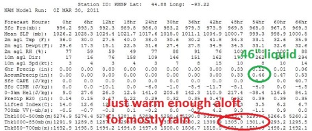
Probably Rain. The next surge of moisture arrives Thursday PM, a thin layer of warm air aloft in place for mostly rain in the Twin Cities area, although we may be close to the rain-snow line, with a sloppy mix possible northern suburbs, maybe 1-3" for parts of central Minnesota. If your travels take you north, to Mille Lacs, Taylors Falls or the Duluth area Thursday night you may drive through a period of heavy, wet, sloppy snow.
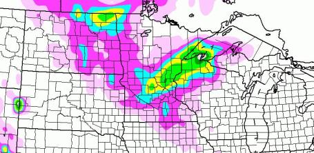
Slipping Into A Stormier Pattern. Models are still printing out anywhere from .40 to .60" liquid on Thursday, the lowest mile of the atmosphere probably (just) warm enough for mostly-rain, but it may be a close call. I could still see a period of slushy snow Thursday night - whatever falls would be gone by late morning Friday. A more significant, long-lasting storm arrives from the Gulf of Mexico late in the weekend, with as much as .50 to .75" liquid possible (again, possibly ending as a period of wet snow).
Thursday Slush? The best chance of a couple of inches of slushy, sloppy snow late Thursday will probably come up north, closer to Duluth and the North Shore of Lake Superior. But a quick coating of wet snow can't be ruled out closer to the metro area. Most roads will probably stay wet, with a little slushy accumulation possible on lawns/fields, especially north/west metro.
First 60 of Spring? No guarantees (there never are), but this is the first time I've seen the models spit out a 60. The GFS is fairly unreliable - we'll see if future runs are as mild, but there's little doubt that we'll see a string of 50s next week, possibly culminating with a 60-degree high on or around April 10. The implications for Minnesota's flood sitation? Still unknown.
Hail in New Orleans. Reports of dime to quarter size hail on Tuesday as severe storms ripped across the Gulf coast. When did we transition from fruit to cash, when describing hail? Seems wrong...
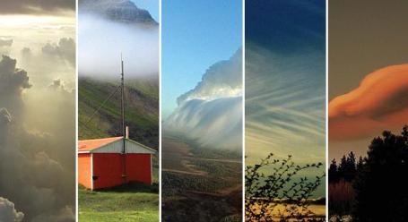
Cloud Field Guide. Farmers and pilots are some of the best weather forecasters - many individuals can literally "read the sky"; based on the type (and trend) of clouds, wind direction and barometric tendencies the average person can make a remarkably accurate 8-12 hour forecast. Now comes
news from the New York Times of a new field guide for cloud enthusiasts: "
Gavin Pretor-Pinney confronts his new book’s major problem right up front. “You might well think,” he writes, “that cloud collecting sounds like a ridiculous idea.” True, he acknowledges, clouds are ephemeral, “magicked into being” by the atmosphere and constantly changing. And, of course, they cannot actually be gathered up and stored away. But as Mr. Pretor-Pinney sees it, you don’t have to possess something to collect it: “You just have to notice it and record it.” Hence “The Cloud Collector’s Handbook,” published by Chronicle Books, a serious yet charming field guide to clouds. The book teaches readers how to identify clouds they have seen and gives them a place to record the sightings, just the way birders create life lists of the birds they have spotted. It even has a scoring system, in which cloudspotters receive 10 points for ordinary clouds like nimbostratus, the more or less featureless rain clouds people typically have in mind when they say clouds are depressing; 40 points for a cumulonimbus storm cloud, the anvil-shaped “king of clouds”; and more points for more exotic formations."
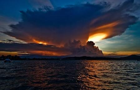
Cloud Appreciation Society. Hey, why not? Especially in Minnesota, where every day is a free show. No two days are identical, meteorologically speaking. And some of the cloud formations visible over Minnesota are nothing shorty of breath-taking. Even if you don't become a card-carrying member of the
Cloud Appreciation Society, take a moment out of every day to look up and take in the free Technicolor Movie playing out overhead: "At
The Cloud Appreciation Society we love clouds, we’re not ashamed to say it and we’ve had enough of people moaning about them.
Read our manifesto and see how we are fighting the banality of ‘blue-sky thinking’. If you agree with what we stand for, then
join the society for a minimal postage and administration fee and receive
your very own official membership certificate and badge."
 Inching Closer To Average
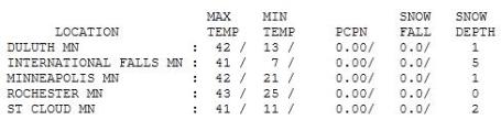
. Here in the Land of Low Weather Expectations 40s are a pretty big deal (after the winter we just endured). 42 to be precise. We're down to 1" of snow on the ground in the Twin Cities, 2" at St. Cloud and 5" left up at International Falls.
 Paul's Conservation Minnesota Outlook for the Twin Cities and all of Minnesota:
WEDNESDAY: Partly sunny, closer to average. Winds: SE 10. High: 44
WEDNESDAY NIGHT: Patchy clouds, not as chilly. Low: 30
THURSDAY: Rain develops - possibly mixed with a little wet snow Thursday night (especially north metro). High: 45
FRIDAY: Drier day, clouds linger. Low: 34. High: 47
SATURDAY: Sneak outside, nicer, sunnier day of the weekend - milder. Low: 34. High: 54
SATURDAY
NIGHT:
Cloudy with rain possible late. Low:
38
SUNDAY: Periods of rain, possible thunder? High: 48
MONDAY: Rain ends as wet snow up north. Low: 37. High: 44
TUESDAY: Peeks of sun, shrinking puddles. Low: 29. High: 45
* A string of 50s likely next week - it will finally start to feel like spring.

Dark Anniversary
Look at the bright side: at least we're not curled up in the fetal position in our basements, listening to storms rage overhead. I have yet to officially use the word "tornadic", on the air or off. On March 29, 1998 a swarm of violent tornadoes swept across southern Minnesota. 13 of 16 observed tornadoes were spawned by a single "supercell" thunderstorm, on the ground for 150 miles. The EF-4 tornado that hit Comfrey, Minnesota damaged 75% of the structures in town; in all 7 counties were declared disaster areas.
Tornado season in Minnesota runs from March 18 to November 16; peak months: May and June.
It's obviously been much too cool and dry for any severe weather, but a warming trend is now in full swing, a string of 40s giving way to mid 50s by Saturday.
A dry sky today gives way to a sloppy mix Thursday: mostly rain, but a coating of slush can't be ruled out Thursday night. A more substantive storm is brewing for early next week, this one brimming with moisture from the Gulf of Mexico. Half an inch or more of (liquid) precipitation may fall by Monday, possibly ending as a little slushy snow up north. Remember, I'm just the messenger.
This is all Al Roker's fault.
Global Warming: Melting Away. An
article from the U.K.'s Express Tribune: "
Inconvenient or not, it is true that the world gets hotter with every passing year. The North Pole is melting so fast that, according to environmentalists, it may no longer exist by 2050. The Antarctic Western Tip is releasing ice much faster than it can replenish it. In Greenland, Alaska and Siberia, permafrost is melting at an alarming rate, transforming once-frozen soil into wetlands. And vanishing glaciers are stripping snow caps on the mountain tops. These overhead water tanks of nature discharge water into the sea at such an alarming rate that some islands in the Maldives may be submerged 50 years from now, and in many countries once fertile lands are turning into deserts. Dr Viner from the Climatic Research Unit at the University of East Anglia points out that nine of the 10 warmest years on record occurred in the last decade and the 2003 July-August heat wave caused over 25,000 deaths in Europe alone, according to the World Health Organisation (WHO). In the same year the world was shocked to hear that a huge chunk of ‘eternal’ ice had broken off Switzerland’s iconic Mount Matterhorn. The cause: excessive heat surrounding the mountain’s external wall. Mountainous Switzerland has been experiencing phenomenally hot weather since 2003. The Alpine area as a whole receives 100 million visitors every year."
 Contrails Warm The World More Than Aviation Emissions
. The New Scientist has an
article about jet contrails - how they often spread out into cirrus clouds, which keep nighttime temperatures warmer: "
The innocuous white vapour trails that criss-cross the sky may not be as harmless as they look. In fact, they might have contributed to more global warming so far than all aircraft greenhouse gas emissions put together. High-altitude clouds like cirrus warm the planet by trapping heat. Contrail "cirrus" does the same thing, but the question is: how much? We know that contrails trap some extra energy in the atmosphere: their radiative forcing trapped 10 milliwatts per square metre (mW/m2) in 2005, according to an estimate by the Intergovernmental Panel on Climate Change. That compares with 28 mW/m2 trapped by all of the CO2 released by aircraft engines since the start of aviation. However, the IPCC estimate only took into account relatively fresh, visible vapour trails that exist for just a few hours. Afterwards they spread out and become indistinguishable from normal cirrus. In this form they may trap energy in the atmosphere for many more hours. "Only a small part of the problem has been studied," says Ulrike Burkhardt of the Institute for Atmospheric Physics in Oberpfaffenhofen, Germany. With her colleague Bernd Kärcher, she set out to discover how much heat contrail cirrus traps."
U.N.: Cities Ignore Climate Change At Their Peril. Here's a
story that ran in the BBC on Tuesday: "
The assessment by UN-Habitat said that the world's cities were responsible for about 70% of emissions, yet only occupied 2% of the planet's land cover. While cities were energy intensive, the study also said that effective urban planning could deliver huge savings. The authors warned of a "deadly collision between climate change and urbanisation" if no action was taken. The Global Report on Human Settlements 2011, Cities and Climate Change: Policy Directions, said its goal was to improve knowledge of how cities contribute to climate change, and what adaptation measures are available."
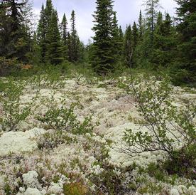
Shift In Northern Forests Could Increase Global Warming. AGW has gone from theory to reality in Alaska and other northern latitudes, as described in a recent article in Scientific American: "
Boreal forests across the Northern hemisphere are undergoing rapid, transformative shifts as a result of a warming climate that, in some cases, is triggering feedback loops producing even more regional warming, according to several new studies. Russia's boreal forest - the largest continuous expanse of forest in the world - has seen a transformation in recent years from larch to conifer trees, according to new research by University of Virginia researchers. In Alaska, where the larch were largely devastated by a disease outbreak in the late '90s, vast swathes of forest are becoming inhospitable to the dominant white and black spruce. "The climate has shifted. It's done, it's clear, and the climate has become unsuitable for the growth of the boreal forest across most of the area that it currently occupies," said Glenn Juday, a forestry professor at the University of Alaska, Fairbanks."
No comments:
Post a Comment