2/10" snow fell on Sunday.
8" on the ground as of Sunday evening.
1/2" snow possible today.
2-4" expected Wednesday (the brunt of the storm passes 75-200 miles south/east of the Twin Cities).
6"+ potential for heavy, wet snow the weekend of March 19-20 (GFS model).

Living On The Edge. Did I miss something? I thought ice houses had to be off the lake by February 28? Maybe that doesn't apply to "DreamShaks". Yep, that's the brand name of that baby. Satellite dish optional.
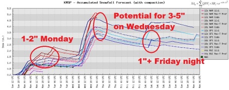
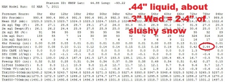
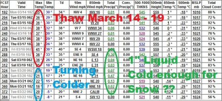
Running The Numbers. The 00z NAM/WRF run prints out about .3" liquid on Wednesday; at a 10/1 snow ratio (which seems reasonable at a 31-34 F. air temperature) that should equate to about 2-4" slushy snow (the best chance of 3 or 4" southern and eastern suburbs). Hardly a snowy catastrophe.
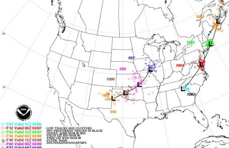
Projected Storm Track. Wednesday's storm is taking a track that is (often) favorable for significant snow across Minnesota. In this case the models (fairly consistently) take the storm about 75-100 miles too far south/east for the heavy snow shield to reach the immediate Twin Cities metro - but it may be a close call, with Iowa, far southern Minnesota and western Wisconsin seeing the heaviest (6-10") amounts.
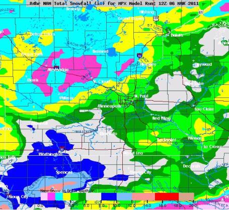
A Big Variation. The NAM already busted (3.2" had fallen on St. Cloud as of Sunday evening). Models are consistently printing out the greatest potential for significant snow south of the Minnesota River Valley, with some 6-8" amounts possible from Glencoe to Mankato and Albert Lea, another region of 6" snows possible east of St. Paul, near Menomonie and Eau Claire. In general, the farther south/east you travel, away from MSP, the heavier snowfall amounts should be. The vast majority of this snow is forecast to come on Wednesday.

Big Numbers. There's a reason why March had the dubious distinction as Minnesota's snowiest month of the year, up until just a few years ago. A higher sun angle is heating up North America, creating huge north-south temperature contrasts. Throw in a fetch of moisture direct from the Gulf of Mexico, and you have many of the ingredients necessary for sloppy southern storms to form, and push north toward the Midwest. I'm hoping these numbers are inflated - the big question mark (with no answer yet) is if the storm predicted for the weekend after next (March 19-20) is real. Too early to know.

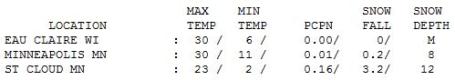

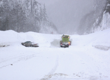
Sunny Start - Snowy Finish. A fast-moving system thickened up the clouds over Minnesota, but the mercury still managed to reach 30 in the Twin Cities, only 23 at St. Cloud and 20 at Alexandria. By 7 pm Sunday evening 3.2" of snow had already fallen on St. Cloud.
Could Be Worse. Yes, it's going to snow this week - but it won't get quite this bad anytime soon.
Paul's Conservation Minnesota Outlook for the Twin Cities and all of Minnesota:
MONDAY: Light snow and flurries, another coating to 1/2" possible - most roads will be wet and slushy. Winds: NE 8-13. High: 28
MONDAY NIGHT: Mostly flurries - little additional accumulation. Low: 22
TUESDAY: Light snow, just a coating during the daylight hours. Steadier snow arrives. Tuesday night. High: 32
WEDNESDAY: More snow, 2-4" slush may fall in the metro (heavier amounts over southeastern MN). High: 34
THURSDAY: Sun peeks out, better travel. Low: 21. High: 32
FRIDAY: Dry start, 1-2" possible Friday night? Low: 22. High: 35
SATURDAY: Leftover flurries, windy & colder. Where is March? Low: 16. High: 22
SUNDAY: Intervals of sun, nicer day of the weekend. Low: 12. High: 28
Parade of Storms
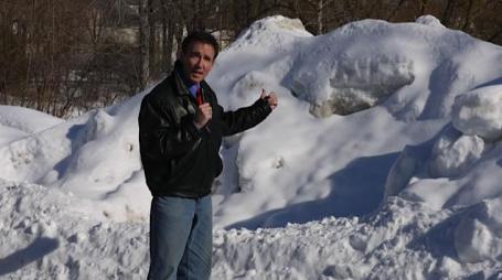
One thing I can predict with (rare) 100% accuracy: we will never EVER take spring for granted again. The miniature glacier outside my window shows no sign of retreating.
Welcome to the snowiest winter in 2 decades. Dave, up at Garceau's, in Vadnais Heights, was all smiles on Saturday. "We love early snows - gets the people out!" They've sold out of snow-blowers 3 times this winter. "We can't keep 'em in stock," he said.
Yes, the sun is as high in the sky as it was on October 2; daylight saving time kicks in next weekend. Then why are we going backwards? At least 3 separate snow "events" arrive this week; a potentially major storm the weekend of March 19-20.
There's good news: no more subzero smacks are in sight - and the brunt of the heaviest snows should pass south/east of MSP on Wednesday. We'll pick up a coating today, maybe another 2-4" slush Wednesday, possibly a couple more Friday night. No risk of "Snowmageddon" until (possibly) the weekend after next (March 19-20). Spring has been delayed (thanks La Nina), and I'm still worried about the implications of a delayed thaw (and a parade of March storms) on river levels come April. It could rival 1965 in some towns.
I hope I'm wrong.
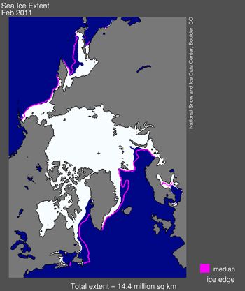
February Sea Ice Extent At Record Low. This is the first I've seen that remarkable warmth in the Arctic region in recent months has had a significant impact on ice levels (which makes sense, of course). February tied 2005 for the lowest levels of ice ever observed. More from NOAA and the Summit County Voice: "SUMMIT COUNTY — Arctic sea ice extent in February tied with 2005 for lowest on record since 1979, when satellite measurements began. Ice covered about 5.54 million square miles of the Arctic area, about half a million square miles below the average. The sea ice extent was below average in both the Atlantic and Pacific sectors, especially in the Labrador Sea and the Gulf of St. Lawrence, according to the monthly update from the National Snow and Ice Data Center. Here’s an excerpt: “While ice extent has declined less in winter months than in summer, the downward winter trend is clear. The 1979 to 2000 average is 15.64 million square kilometers (6.04 million square miles). From 1979 through 2003, the February extent averaged 15.60 million square kilometers (6.02 million square miles). Every year since 2004 has had a mean February extent below 15 million square kilometers (5.79 million square miles).”
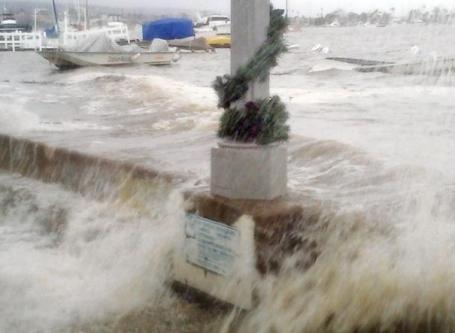
Even Conservative Newport Beach (California) Gets Serious About Rising Sea Levels. An article from the L.A. Times: "Communities up and down the coast have begun drafting plans to build up wetlands as a buffer against rising tides, to construct levees and seawalls to keep the waters at bay or to retreat from the shoreline by moving structures inland. Among them is Newport Beach, a politically conservative city where a councilmember once professed not to believe in global warming. Now, the wealthy beach city is considered to be at the forefront of preparing for climate change. Though some in Newport Beach remain skeptical that global warming caused by humans is elevating sea levels, city planners are looking at raising seawalls by a foot or more to hold back the ocean. New homes along the city's harbor are being built on foundations several feet higher than their predecessors as a precaution against flooding."

The Next Smart Thing. Nathan Myhrvold is the former Technology Officer of Microsoft, now a venture capitalist funding a number of projects. His "solution" for global warming? Geoengineering. Take a deep breath, and check out this article in the Wall Street Journal: " MR. MURRAY: Global warming. You've taken it on. You've gotten some criticism for your approach. MR. MYHRVOLD: The first thing that is not obvious to people is global warming is a less-than-1% effect. It's like being shortchanged at the bank by a penny every dollar. Over a long period of time with lots of transactions, that piles up. It's hard to predict with perfect accuracy, hard to predict what effect that will have on Earth. The speculation includes things that could be catastrophic, like, oh, Greenland falls into the water. Now there's some people that think that's absolutely going to happen. There's some people that think that's highly unlikely. We don't actually know enough about the physics of that, because we haven't watched it. MR. MURRAY: So the solution is? MR. MYHRVOLD:The most dramatic approach is to say, "Can we cool Earth off?" The answer to that, surprisingly, is yes. And the reason goes back to it being a 1% effect. All you have to do is reflect 1% roughly of the light that hits Earth before it comes down, and you've solved the entire problem. It was recognized in the 1960s that sulfur dioxide does this naturally in the atmosphere. For relatively modest amounts of sulfur dioxide injected into the atmosphere, you could easily cool Earth by 1% or more, if you want. Many of the people involved in the debate are anti-technology. Their argument is, "Guys like you got us in this problem; why the hell should we let you go do this again?" And the answer to that is, of course: As soon as we developed agriculture, as soon as our population increased from a couple million across the whole planet, all of those things were unsustainable in the sense that we would have growth rates that depended on us getting smart and figuring something else out. The whole question is, do we give the human race half a chance to figure out that next smart thing."
No comments:
Post a Comment