* As many as 4-6 separate "snow events" through the third week of March as we enter a much more active (ie. stormier) weather pattern.
* NWS may issue a Winter Storm Watch as early as this evening.
* GFS model hinting at 12-18" of snow for much of the metro by March 22. We'll see.
* Flood threat continues to rise with additional precipitation in the forecast, and no sign of an extended thaw over the next 1-2 weeks. I still suspect this spring's flood scenario may be worse than any year since 1997, possibly rivaling 1965 in some communities.

Latest Numbers. The 12z NAM prints out .58" by Wednesday evening. That should mean 1-2" by tomorrow, another 2-4" Wednesday as a significant storm tracks from Texas to St. Louis to near Rockford, Illinois, a little too far south/east for heavy snow in the immediate metro area.
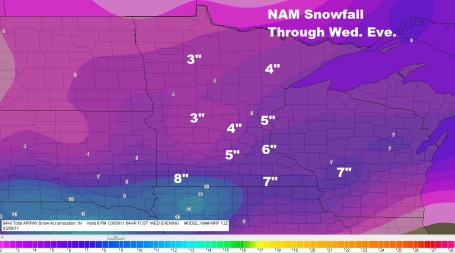
A Reasonable Solution. The 12z Sunday morning NAM run prints out about 4-6" (total) by Wednesday night, which doesn't seem unreasonable, based on the latest consensus of model runs. As much as 8-9" may brush far southern Minnesota. Map courtesy of F5data.com.
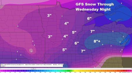
Continuity. Here is the GFS solution, for the samme period, showing a tota of 5-6" over much of the metro, more south and east - fairly close to the NAM/WRF solution. Confidence levels are growing that we'll see enough to shovel and plow on Wednesday, but probably not the Big One.
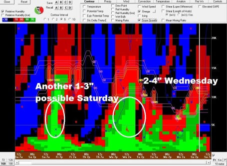
Parade Of Storms. The Bufkit solution (which reads from right to left - go figure) shows enough upward velocity and moisture for a quick inch or 2 from Sunday night into Monday, 2-4" Wednesday, another couple of inches Friday into Saturday morning, ahead of the next clipper, which will drop temperatures over the weekend.
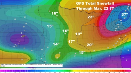
Out To Lunch? The GFS has been spitting out some eye-glazing numbers in recent days, but this may be tracking (a little) closer to reality, hinting at 4-6 snow events between now and March 22. The GFS prints out a total of 17-19" for much of the Twin Cities metro by March 22, closer to 16" in St. Cloud and Brainerd, well over 20" across Wisconsin. Hope the GFS has lost its digital mind...
No comments:
Post a Comment