* A dramatic warming trend is likely this week, which has obvious implications for Minnesota's flood risk. Details in the blog below.
* 50+ temperatures possible by Wednesday and Thursday across portions of central and southern Minnesota.
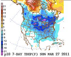
* GFS model hinting at temperatures close to 60 F. on Sunday, March 20, again Sunday, March 27. We'll see. I suspect there's still too much snow on the ground for readings that mild, but the more snow we lose the more of the sun's energy that can go into heating up the air, vs. melting snow cover.
* Light showers possible Tuesday, more significant rain late Saturday into Sunday, possibly ending as wet snow a week from today.
* Stormier pattern shaping up for the last week of March.
* More information on the Japan earthquake, tsunami, partial nuclear meltdown and volcanic eruption.
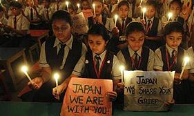
Consider A Donation. I realize there are a lot of worthy causes out there competing for our time and dollars. But the tragedy in Japan transcends anything we've seen in recent years, thought to be 700 times more powerful than the quake that rocked Haiti last year. The death toll will almost certainly rise into the tens of thousands, hundreds of thousands of people displaced from their homes. Click
here to make a donation to the Red Cross.
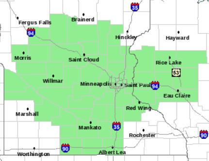
Hydrological Outlook. There are no flood warnings in effect (yet), but Sunday night the local NWS office issued the following hydrological outlook for our river basins. The risk of flooding is still extremely high, but most rivers probably won't reach or exceed flood stage for 2-3 weeks. The timing is very tricky, depending on whether nighttime temperatures stay above freezing the next 1-2 weeks - and the amount of rain (or snow) between now and the first week of April:
HYDROLOGIC OUTLOOK
NATIONAL WEATHER SERVICE TWIN CITIES/CHANHASSEN MN
549 PM CDT SUN MAR 13 2011

...WARM TEMPERATURES THIS WEEK ARE EXPECTED TO INCREASE MELTING
AND POTENTIALLY LEAD TO RIVER FLOODING AS EARLY AS NEXT WEEKEND...

A CHANGE IN THE WEATHER PATTERN WILL BRING WARMER TEMPERATURES TO
CENTRAL AND SOUTHERN MINNESOTA AS WELL AS WEST CENTRAL WISCONSIN
TUESDAY AND ESPECIALLY INTO WEDNESDAY AND THURSDAY. TEMPERATURES
WILL BE IN THE LOWER AND MID 40S ON TUESDAY AND IN THE UPPER 40S
AND LOWER 50S ON WEDNESDAY AND THURSDAY. HIGHS ON FRIDAY WILL BE
COOLER...BUT STILL IN THE MID 30S IN WEST CENTRAL MINNESOTA TO THE
LOWER AND MID 40S IN SOUTH CENTRAL MINNESOTA AND INTO WEST CENTRAL
WISCONSIN.

LOWS WEDNESDAY MORNING ARE EXPECTED TO BE IN THE MID TO UPPER 20S
WHICH WILL HELP SLOW THE MELTING PROCESS FROM TUESDAY. BUT FOR
OVERNIGHT WEDNESDAY NIGHT AND INTO THURSDAY MORNING...TEMPERATURES
ARE NOT EXPECTED TO DROP BELOW FREEZING ACROSS SOUTH CENTRAL AND
EAST CENTRAL MINNESOTA. PARTS OF WEST CENTRAL WISCONSIN WILL ONLY
DROP TO AROUND 40 DEGREES. LOWS FRIDAY MORNING WILL RANGE FROM THE
MID 20S IN CENTRAL MINNESOTA TO THE LOWER 30S IN SOUTH CENTRAL
MINNESOTA. LOWS IN WEST CENTRAL WISCONSIN WILL DROP INTO THE UPPER
20S. HENCE THE MELTING PROCESS WILL CONTINUE FROM WEDNESDAY
THROUGH THURSDAY NIGHT. SO A GOOD 36 HOURS OF STRAIGHT MELTING IS
LIKELY.

WE ARE ALSO LOOKING AT A COUPLE OF CHANCES OF LIGHT RAIN IN THE
NEXT 7 TO 10 DAYS. THE FIRST CHANCE WILL BE ON TUESDAY. AT THIS
TIME THE SYSTEM DOES NOT TAP INTO THE GULF OF MEXICO FOR A
MOISTURE SOURCE...SO PRECIPITATION AMOUNTS WILL BE LIGHT AND
AROUND A TENTH OF AN INCH OR LESS. ANOTHER SYSTEM WILL MOVE
ACROSS THE AREA ON THURSDAY. AS WITH THE TUESDAY SYSTEM
PRECIPITATION AMOUNTS ALSO LOOK LIGHT. WE ARE WATCHING ANOTHER
STRONGER STORM SYSTEM FOR LATE NEXT WEEKEND AND INTO PART OF NEXT
WEEK. THIS ONE MAY BE ABLE TO TAP INTO THE GULF OF MEXICO. THIS
SYSTEM IS STILL AT LEAST 7 DAYS OUT IN THE FORECAST SO PATTERNS
MAY CHANGE BUT IT IS WORTH WATCHING FOR A RAIN EVENT.

THE WARMING TEMPERATURES FOR THE MIDDLE PART OF THE WEEK ARE
EXPECTED TO BEGIN MELTING THE SNOW. AT THIS POINT...WE ARE
EXPECTING RISES IN THE MAIN STEM RIVERS BEGINNING...INTO THE
LATER PART OF THE WEEK. HOW WARM WE ACTUALLY GET DURING THE
DAY...AND HOW WARM WE REMAIN OVERNIGHT AS WELL AS OUR MOISTURE
LEVELS AND WINDS...WILL BE THE MAIN DRIVERS FOR THE MELT.

AT THIS POINT WE COULD SEE SIGNIFICANT RISES ESPECIALLY FOR THE
COTTONWOOD...REDWOOD...MINNESOTA...CROW AND MISSISSIPPI FOR ST
PAUL AND DOWNSTREAM...AND THE ST CROIX RIVER BASINS OVER THE NEXT
FIVE TO TEN DAYS. FOR THESE RIVER BASINS...WE COULD POSSIBLY SEE
FLOOD STAGE LEVELS AS EARLY AS NEXT WEEKEND.

FOR THE LONG PRAIRE...SAUK...THE MISSISSIPPI RIVER FOR MINNEAPOLIS
AND UPSTREAM...EAU CLAIRE AND CHIPPEWA RIVER IN WISCONSIN
BASINS...WE ARE LOOKING FOR RISES BUT AT THIS POINT INDICATIONS
ARE THAT THEY WILL REMAIN BELOW FLOOD STAGE FOR THE NEXT WEEK.

AS CONFIDENCE INCREASES ON THE MELT AND IMPACTS ON THE
RIVERS...RIVER FLOOD WATCHES AND...OR WARNINGS WILL LIKELY BE
ISSUED BY WEDNESDAY.
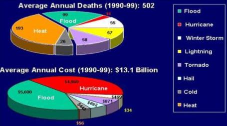
. This is Flood Safety Awareness Week nationwide; according to NOAA river flooding and flash flooding cost America an average of over $13 billion a year in the 1990s, the second greatest cause of deaths in the USA, second only to extreme heat. Click
here for a wealth of flood-related information. Highly relevant, considering we may be facing severe flooding within 2-4 weeks.
Milder & Stormier. The GFS is suggesting highs well up into the 50s to near 60 by Sunday, again the following Sunday (March 27). I'm not convinced it's going to get that mild, but a string of 50s appear likely later this week into the following week. Little rain is expected this week, but moisture from the Gulf of Mexico may reach Minnesota next week with a series of storms brushing Minnesota with potentially significant moisture. Any rain will accelerate snow melt. The ground is frozen (and saturated, the resulf of a record wet 2010), which means snow melt will almost immediately run off into area streams and rivers. No flooding is expected this week, but some streams and rivers may approach flood stage as early as next week. I still suspect the worst flooding will arrive the first 2 weeks of April, but that (as always) is subject to change - it all depends on the rate of warming (and whether we pick up substantial rain/snow).
 Sunday Thunder?
 The GFS brings a strong warm front northward into Minnesota over the weekend - I wouldn't be surprised to see heavy showers, even a few embedded thunderstorms close to home by Sunday. Hope I'm wrong - any downpours would present a worst-case scenario for flood potential.
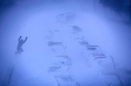
Troopers: 800 Motorists Rescued After North Dakota Blizzard. The vigorous Alberta Clipper that whipped up 40-55 mph. winds across Minnesota Friday night and Saturday morning was more than an inconvenience across North Dakota, where winds gusting over 70 mph. created white-out conditions. A
story from the Bismarck Tribune: "
Rescue workers used military trucks and other heavy vehicles to pluck motorists from more than 500 vehicles abandoned along ice-slicked roads and in drifting snow throughout North Dakota and take them to churches, schools, bars and gas stations that became makeshift shelters. About 800 people were rescued starting Friday afternoon, and most remained at shelters Saturday as highways remained closed. North Dakota National Guard spokesman Capt. Dan Murphy said the rescue mission ended Saturday morning but soldiers were still on duty, patrolling highway entrances. Only minor injuries had been reported following hundreds of pileups and crashes, Highway Patrol Lt. Jody Skogen said. A no travel advisory had been lifted, but snow and abandoned cars still blocked the roads, authorities said. Winds of more than 60 mph created whiteouts during Friday's blizzard. North Dakota State College freshman Katie Woodbury was driving from the school in Fargo to her family's farm in Stanley, in northwest North Dakota, when road conditions forced her take shelter at a church in Medina."
An Extreme February. Jeff Masters at Wunderblog has a thoroughly mind-blowing
recap of February's global weather extremes. Another amazing month: "
Extreme weather highlights for this past February include more extraordinary snowfalls in the U.S.A. (along with some record low temperatures) and more torrential rains and floods in Australia and South America.
NORTH AMERICA
The month opened with a humongous blizzard paralyzing the Midwest of the United States. Chicago reported its third greatest snowfall on record with 20.2” measured at O’Hare Airport on February 1-2. Tulsa, Oklahoma’s 14.0” accumulation was the greatest on record for that city."
Northern Plains To The Northeast: Don't Put Away The Snow Shovels Just Yet. Meteorologist Joe Bastardi (who was a ficture at Accu Weather for nearly 30 years) is now working for a private weather firm based in New York City called "Weather Bell". Here is his
long-range outlook. Caveat/warning: Joe likes snow. No, Joe REALLY likes snow. I, for one, hope he's wrong: "
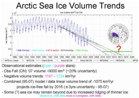
Like it or not, this is an ugly pattern and is probably “locked” for a while with troughs deepening in a major fashion in the east enough to warrant concern for significant winter events at least as far south as I-80 into April. In addition, for all you sea ice fans, the development of the positive over the top like that means that winds are light in sea ice land and chances are like last year the sea ice lags in its melting time and given what we are looking at for the northern hemisphere summer this year, there will not be the melt off we had last year. which is also part of this whole global pattern backdrop that is helping catch some things. Another story for another time."
Brief Winter Relapse? Nothing more invigorating than April snow and cold. According to NOAA (and Weather Bell) we may see a relatively brief return of cold (and possibly snow) the last few days of March. Great.
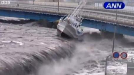
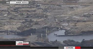
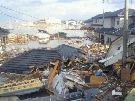
Footage Of Moment Tsunami Struck. I have never seen anything like this - the exact moment a 20-30 foot surge of water struck the coastline of Japan, in the little village of Miyako. Here's the
video from the BBC: "Newly emerged footage shows the force at which the tsunami struck Japan's coast. In the fishing port of Miyako, in Iwate prefecture, boats were overturned, while video from Kamaishi city shows cars being dragged down city streets by the water. The tsunami that followed the 8.9-magnitude earthquake wreaked havoc along a huge stretch of Japan's north-east coast, sweeping far inland and devastating a number of towns and villages. Powerful aftershocks are continuing to hit the region.
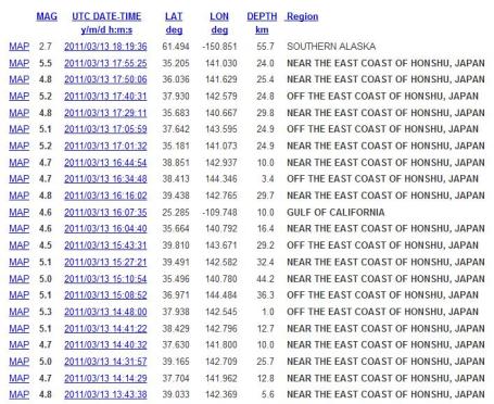
Latest Earthquakes In The World - Last 7 Days. Click
here to see the latest quakes and minor tremors (in chronological order) from USGS: "
This list contains all earthquakes with magnitude greater than 2.5 located by the USGS and contributing networks in the last week (168 hours). Magnitudes 4.5 and above are in bold font. Magnitudes 6 and above are in red. (Some early events may be obscured by later ones on the maps.) The most recent earthquakes are at the top of the list. Times are in Coordinated Universal Time (UTC). Click on the word "map" to see a ten-degree tall map displaying the earthquake. Click on an event's "DATE" to get a detailed report."
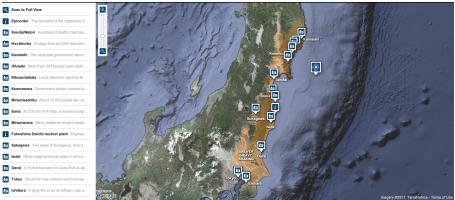
Map Of Damage From The Japanese Earthquake. Click
here to see an interactive map from the New York Times: "
An interactive map and photographs of places in Japan that were damaged by the March 11 earthquake and tsunami."
Quake Damages More Than 46,000 Buildings. NHK World in Japan
reports: "
The Japanese government estimates that more than 46,000 homes and buildings were damaged by the devastating earthquake and tsunami that hit northeastern Japan on Friday. The government says about 5,700 of the structures collapsed in the quake or were washed away by the tsunami. They include 3,056 structures in Iwate Prefecture, 2,413 in Fukushima, 86 in Miyagi, 80 in Ibaraki, 38 in Yamagata, 15 in Tochigi, 14 in Chiba, 3 in Tokyo, and one each in Kanagawa and Akita."
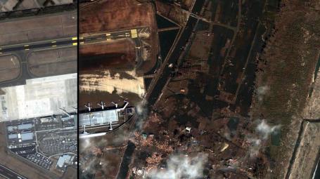
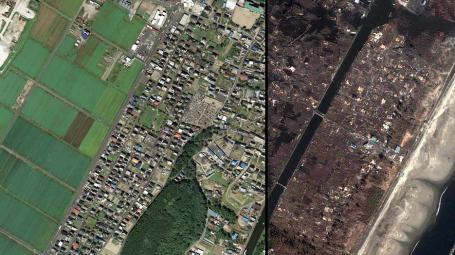
Japan Earthquake: Before And After. A remarkable
story from the ABC Network in Australia: "
Aerial photos taken over Japan have revealed the scale of devastation across dozens of suburbs and tens of thousands of homes and businesses. Click on the link and hover over each satellite photo to view the devastation caused by the earthquake and tsunami."
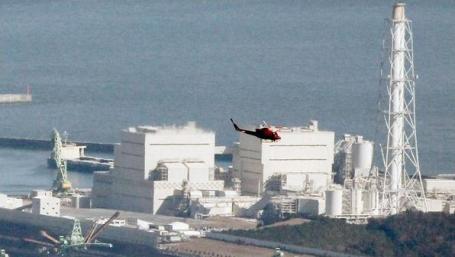
Danger Posed By Radioactivity In Japan Hard To Assess. An
update on a very complicated (and worrisome) scenario unfolding at least two nuclear reactors damaged by the 8.9 quake from the New York Times: "
The different radioactive materials being reported at the nuclear accidents in Japan range from relatively benign to extremely worrisome. The central problem in assessing the degree of danger is that the amounts of various radioactive releases into the environment are now unknown, as are the winds and other atmospheric factors that determine how radioactivity will disperse around the stricken plants. Still, the properties of the materials and their typical interactions with the human body give some indication of the threat. “The situation is pretty bad,” said Frank N. von Hippel, a nuclear physicist who advised the Clinton White House and now teaches international affairs at Princeton. “But it could get a lot worse.”
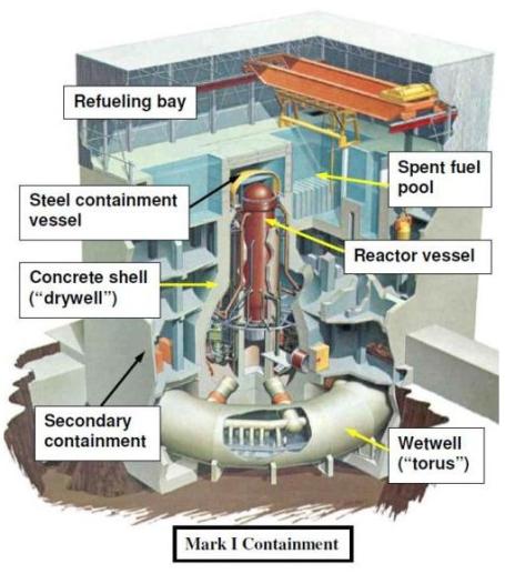
Update On Fukushima Reactor. Partial meltdown? Complete meltdown? There's a lot of conflicting information about what's happening with Japan's damaged nuclear reactors.
Here's an explanation from the Union of Concerned Scientists: "On Saturday March 12 at 3:36 pm local time (1:36 am EST) an explosion occurred in the Unit 1 reactor building at the Fukushima Dai-ichi nuclear plant. (Original reports suggested that the explosion took place in an adjacent turbine building, but we no longer believe this is the case.) The explosion was very likely a hydrogen explosion. Hydrogen apparently collected somewhere in the reactor building outside of the primary containment (see diagram below). The primary containment consists of the drywell and the wetwell. The top section of the reactor building, known as the refueling bay, has walls of sheet metal, in contrast to the concrete walls of the lower part of the building. The pressure caused by a large enough explosion anywhere in the reactor building would have caused the sides of the refueling bay to blow out since that is the weakest part of the structure and is not designed to withstand high pressures."
. The Richter scale is logarithmic - meaning an 8.0 is 10 times stronger than a 7.0, 100 times stronger than a 6.0. Here's a
story from the Huffington Post: "
The Japan earthquake had a depth of 15.2 miles. The January 2010 earthquake in Haiti, by comparison, had a magnitude of 7.0 and occurred at a depth of only about 8.1 miles. The February 2010 Chile earthquake, which registered a similar magnitude as the Japan quake, 8.8, took place 22 miles below the earth's surface, off the coast of the South American nation."
Japan Quake Will "Shift Earth's Mass" - NASA Expert. A remarkable
story from dailygalaxy.com that puts the Japan quake into global perspective: "
NASA Jet Propulsion Laboratory’s (JPL) specialist Richard Gross has stated that following the earthquake the Earth’s figure axis (the axis around which the Earth is balanced by mass) has shifted by about 15 centimeters - 2 times greater than after the Chilean earthquake of 2010. "According to my calculations, the length of the day should be reduced to 1.6 microseconds (millionths of a second). The earthquake in Chile gave, in my opinion, a reduction of approximately 1.2 microseconds,” he said. According to Gross, the Earth’s axis shifted to the 139th degree east longitude. After Chilean cataclysm in 2010 it shifted to 112th degree east longitude. The Earth has its own mass-shifting movements, according to Gross: for example, in February 2010, the Nazca tectonic plate in the eastern Pacific Ocean basin moved, causing a destructive 8.8 magnitude earthquake in Chile. But its type—a thrust earthquake—counted most for Earth’s rotation."
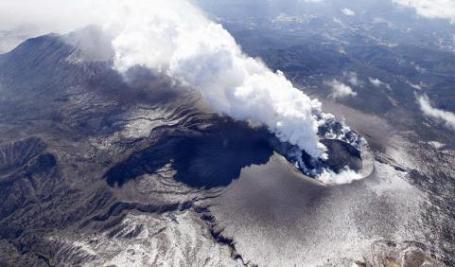
Japanese Volcano Erupts. As if an 8.9 earthquake, 20-30 foot high tsunami and nuclear meltdowns weren't enough. Residents of Japan must be wondering what's next? An
update from the U.K.'s Sunday Times: "
It was not immediately clear if the eruption was a direct result of the massive 8.9-magnitude earthquake that rocked northern areas Friday, unleashing a fierce tsunami and sparking fears that more than 10,000 may have been killed. The 1,421-metre (4,689-feet) Shinmoedake volcano in the Kirishima range saw its first major eruption for 52 years in January. There had not been any major activity at the site since March 1. Authorities have maintained a volcano warning at a level of three out of five, restricting access to the entire mountain."
* The New York Daily News
reports that hundreds of local residents have fled the volcanic eruption.
All The Aggregation That's Fit To Aggregate. That 'dang Huffington Post. A
story (plea?) from the publisher of the New York Times: "
According to the list makers at Forbes, I am the 50th most powerful person in the world — not as powerful as the Pope (No. 5) but more powerful than the president of the United Arab Emirates (56). Vanity Fair, another arbiter of what matters, ranked me the 26th most influential person in the country. The New York Observer, narrowing the universe to New York, put me 15th on its latest “Power 150,” a list that stretches from Michael Bloomberg to Lady Gaga. New York magazine asked Woody Allen to name the single most important person in our city; he named — aw, shucks — me...“Aggregation” can mean smart people sharing their reading lists, plugging one another into the bounty of the information universe. It kind of describes what I do as an editor. But too often it amounts to taking words written by other people, packaging them on your own Web site and harvesting revenue that might otherwise be directed to the originators of the material. In Somalia this would be called piracy. In the mediasphere, it is a respected business model. The queen of aggregation is, of course, Arianna Huffington, who has discovered that if you take celebrity gossip, adorable kitten videos, posts from unpaid bloggers and news reports from other publications, array them on your Web site and add a left-wing soundtrack, millions of people will come. How great is Huffington’s instinctive genius for aggregation? I once sat beside her on a panel in Los Angeles (on — what else? — The Future of Journalism). I had come prepared with a couple of memorized riffs on media topics, which I duly presented. Afterward we sat down for a joint interview with a local reporter. A moment later I heard one of my riffs issuing verbatim from the mouth of Ms. Huffington. I felt so . . . aggregated."
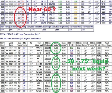
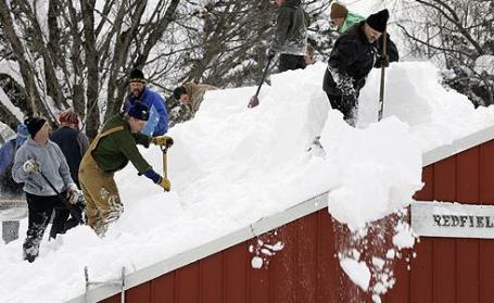
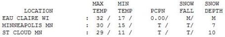
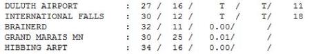
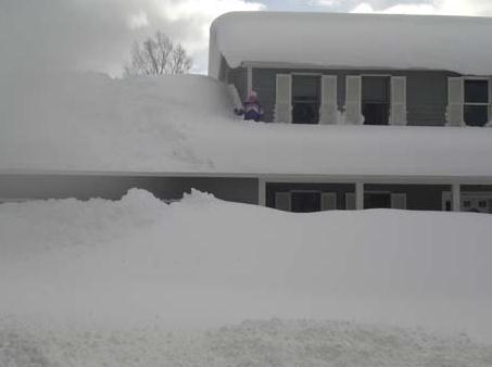
Chilly Sunday. The sun broke through, but it didn't help much, temperatures running 5-10 degrees cooler than average. Snwo on the ground ranges from 7" at MSP to 10" in St. Cloud, 11" at Duluth and 18" reported at International Falls.
Paul's Conservation Minnesota Outlook for the Twin Cities and all of Minnesota:
TODAY: Partly sunny, turning milder. Winds: S 10-15. High: 35
MONDAY NIGHT: Patchy clouds, not as cold. Low: 31
TUESDAY: More clouds, passing rain shower or two. High: 42
WEDNESDAY: Intervals of sun, feels like April! Low: 34. High: 51
THURSDAY: Springlike, slight shower chance. Low: 39. High: 52
FRIDAY: Sun returns, slightly cooler. Low: 33. High: 46
SATURDAY: Windy, still mild. PM shower? Low: 30. High: 48
SUNDAY: Heavier showers possible, risk of mud. Low: 33. High: 47
:
The Big Melt
My joy at an (instant) spring is muted by two factors: the horrific pictures & stories coming out of Japan, and the potential for severe flooding on Minnesota's rivers in about 2-4 weeks.
This is pretty typical for a Minnesota "spring"; blink, sneeze, check your Facebook account, and you may miss spring altogether. A surge of Pacific air tugs the mercury into the 40s by Tuesday; low 50s very possible midweek. No dimmer switch on the atmosphere. Warmth is either ON or OFF. After 80.2" snow (7th snowiest on record) we can be forgiven cheering on the 50s. Good news: only light (rain) showers Tuesday, models hinting at heavier showers this weekend, possibly ending as snow next Monday. Too early to speculate about amounts, but we are heading into a stormier pattern.
Much of our snow will be gone by the weekend; models hinting at 60 by Sunday, the 20th! More on the remarkable temperature boomerang, along with an analysis of Japan's crippled nuclear reactors on my blog.
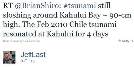
The 20-30 ft. tsunami claimed far more lives than the actual earthquake itself; many cities (including Tokyo) received a 10-30 second advance warning. Help victims by donating to the Red Cross; links on the blog.
Yes, Climate Change May Cause More Earthquakes - No, That's Not Alarmism. I was highly skeptical when I first saw this
story come across my desk. Stop trying to attribute EVERYTHING that goes wrong to climate change! It's true that rising sea levels would amplify the effects of tsunamis, just as they have hurricane storm surges. Here's the story from treehugger.com: "
I know headlines like that might just make most folks roll their eyes at this point -- I mean, what doesn't climate change cause these days, am I right? And I realize that people are skeptical of news-cycle tie-ins, like this very story appears to be. But just because it's sort of depressing to keep tabs on all of the myriad impacts of ol' climate change occurring the world over, doesn't mean we should be glossing over facts like this: Some geologists believe that global warming may already be causing more earthquakes, tsunamis, and volcanic eruptions. After all, screwing with the world's ornery climate system to the extent which we have is bound to have far-reaching effects -- effects like, it's been suggested, huge amounts of melting ice causing the earth's crust to "bounce" up, potentially triggering earthquakes.If you ask me, now is a perfectly reasonable time to be analyzing such possible causal relationships, like the one between climate change and earthquakes (which set off tsunamis). You are, after all, perhaps turning to a green site like TreeHugger to examine the environmental implications of various world events. But some insist this reeks of opportunism (especially those amongst the anti-climate crowd) -- and therefore should be immediately written off as sensationalism. "
"
In a little-heeded warning issued at a 2009 conference on the subject, experts outlined a range of mechanisms by which climate change could already be causing more earthquakes, tsunamis, and volcanic activity. "When the ice is lost, the earth's crust bounces back up again and that triggers earthquakes, which trigger submarine landslides, which cause tsunamis," Bill McGuire, professor at University College London, told Reuters.
Melting ice masses change the pressures on the underlying earth, which can lead to earthquakes and tsunamis, but that's just the beginning. Rising seas also change the balance of mass across earth's surface, putting new strain on old earthquake faults, and may have been partly to blame for the devastating 2004 tsunami that struck Southeast Asia, according to experts from the China Meteorological Administration."
 Global Warming May Severely Impact U.S. Naval Forces
. I
have a son at the Naval Academy, so this
article caught my eye more than others. Rising sea levels are on factor, but thinning Arctic ice has other implications for oil exploration; countries scrambling to find (and tap) new reserves for thirsty consumers. From sify.com: "The report brings to the attention of U.S. naval leadership areas that need attention in future planning and that will prepare the Navy for a warmer world." Kennicutt points out that if the polar icecaps in Greenland and Antarctica continue to melt, sea levels around the world will dramatically rise. Rising sea levels could have wide ranging detrimental impacts on naval facilities now and in the future, the report says. "Arctic sea ice is melting much faster than predicted just a few years ago, so much so that there could be a summer, ice-free Arctic Ocean in a matter of years," he explained. He adds that conflict over new national boundaries in the Arctic has already strained our relations with Canada, since much of Canada's territory is in the Arctic and their claims overlap with U.S. claims. The U.S. considers the Northwest Passage international waters, whereas Canada sees them as within its national boundaries. "How this will affect U.S. national and homeland security is open to debate, but it is clear that an ice-free summer Arctic will dramatically change the politics and military strategies of the north for the foreseeable future," Kennicutt said.

. "Do as I say, not as I do." This
story in the New York Times outlines some of the hypocrisy from avowed liberals crying out for "green options", so long as it isn't in their back yards: "
Park Slope, Brooklyn. Cape Cod, Mass. Berkeley, Calif. Three famously progressive places, right? The yin to the Tea Party yang. But just try putting a bike lane or some wind turbines in their lines of sight. And the karma can get very different. Last week, two groups of New Yorkers who live “on or near” Prospect Park West, a prestigious address in Park Slope, filed a suit against the administration of Mayor Michael R. Bloomberg to remove a nine-month-old bike lane that has commandeered a lane previously used by cars. In Massachusetts, the formidable opponents of Cape Wind, a proposed offshore wind farm in Nantucket Sound, include members of the Kennedy family, whose compound looks out over the body of water. In Berkeley last year, the objections of store owners and residents forced the city to shelve plans for a full bus rapid transit system (B.R.T.), a form of green mass transit in which lanes that formerly served cars are blocked off and usurped by high-capacity buses that resemble above-ground subways."
"
Sen. James Inhofe and some other politicians are claiming climate change is a hoax. In doing so they exhibit a striking disconnect with the vast majority of climate scientists who have devoted their lives to the subject.
For decades now those scientists have been warning us of damaging environmental consequences due to unrestrained emissions of greenhouse gases. Prestigious scientific bodies like the American Meteorological Society, the American Geophysical Union, the American Physical Society and the National Academy of Sciences have issued public statements to this effect. On the other hand, how many established scientific bodies have issued statements backing up Sen. Inhofe’s side of this “controversy?” Zero.
But the indefatigable Sen. Inhofe, who has no scientific background whatsoever, seems unfazed. Rather than deferring to the people who actually know something about the subject, he accuses them of perpetrating a vast hoax. Think of just how preposterous this is. Are we to believe that thousands of climate scientists have suddenly decided to abandon their professional integrity and throw their careers into jeopardy by engaging in an enormous conspiracy of lies designed to sabotage the American economy?
It is shameful to treat a scientific topic as a political football. Mother Nature neither knows nor cares about politics. The Arctic Sea ice will not stop shrinking, the glaciers will not stop receding, the ocean levels will not stop rising, and the atmospheric carbon dioxide levels will not stop increasing merely because it is inconvenient to someone’s political philosophy.
It would be the height of irresponsibility to gamble with the fate of the planet by disregarding the vast majority of climate scientists. If we allow this to happen, the future generations who are left to deal with the consequences of our folly will rightly hold us in contempt."
James J. Amato
Duluth
(reproduced from the Duluth News Tribune)


No comments:
Post a Comment