Slight risk of severe storms later today over the southern 1/3rd of MN (best chance tonight over southern Minnesota).
Moderate risk of severe T-storms Sunday over much of southeastern Minnesota, including the Twin Cities metro area.
Watches/Warnings: I do expect the local NWS office to issue severe storm bulletins Sunday, best chance after 3 or 4 pm.
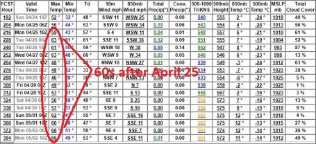
+3.8 F April temperatures in the Twin Cities are running nearly 4 degrees warmer than average.
64 F. high on Friday in the Twin Cities.
53 F. average high for April 8.
68 F. high predicted later in the day Saturday (assuming a few hours of sunshine).
76 F. high on tap for Sunday. A "dry tongue" (surge of dry, desert air wrapped up in the storm's circulation) should brighten skies around midday into the early afternoon hours, allowing the mercury to reach the 70s. Some low 80s are possible over southeastern Minnesota Sunday afternoon.
October 12, 2010. the last time the mercury topped 70 in the Twin Cities (72 F.)
Gulley-Gushing Rains. There are some big discrepencies between the models (nothing new there), but most are now predicting anywhere from 1-2" rain from the upcoming storm. Most of that rain should fall Sunday night, but scattered T-storms Saturday night through Sunday evening will produce huge variations in rainfall amounts.
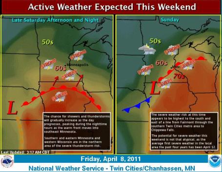 Cue The Sirens. And to think, just 2 1/2 weeks ago we were digging out from 4-8" of snow across the metro area. I guess we shouldn't be too surprised, according to the National Weather Service the average date of the first severe weather outbreak in Minnesota is April 12. A combination of muggy air (surface dew points rising into the 60s), strong wind shear aloft (changing wind speed/direction with altitude) and severe instability may set the stage for a few severe storms, most likely Saturday night into Sunday evening. More from the local NWS office: "The first severe thunderstorms of the season may impact a portion of the area over the weekend. Warmth and moisture will initially surge north into the area late Saturday and Saturday night, bringing scattered thunderstorms into the region as they do so. The surface warm front will move north into south central and east central Minnesota and west central Wisconsin Sunday afternoon into Sunday evening as a strong area of low pressure lifts northeast from the central Plains into south central Minnesota. Large hail will be the primary severe weather threat Saturday night into Sunday morning, with large hail, damaging winds, and a few tornadoes a possibility Sunday afternoon into Sunday evening. Be sure to keep abreast of the latest weather information this weekend as this potential severe weather situation becomes better defined."
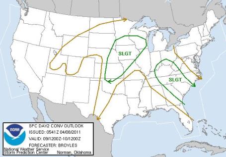 Saturday Severe Risk. The southern third of Minnesota is in a slight risk of isolated severe storms today - the greatest potential for hail and strong winds will come tonight, as T-storms flare up along an advancing warm frontal boundary.
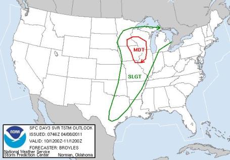 Moderate Severe Weather Risk for Sunday. There are 3 levels of severe forecasts issued by SPC days in advance of an outbreak: slight, moderate and high. A moderate risk means that NOAA meteorologists in Norman, Oklahoma have a high level of confidence that dynamics will be present for a fairly widespread outbreak of severe storms. The greatest risk of large hail, damaging straight-line winds and isolated tornadoes will come south/east of MSP, it all depends on 1). how intense the area of low pressure is, and 2). the precise track of the surface low, whether the warm, 70 (and 80) degree air surges into far southeastern MN ahead of the low, setting up extreme instability and wind shear for a few large, long-lasting tornadoes. On Sunday you'll want to go about your normal activities but stay alert, stay tuned to local media, and be ready to take cover if threatening weather approaches.
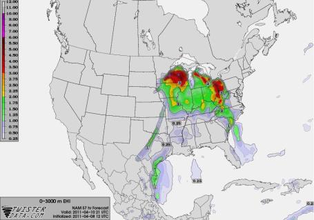 Ripe For Isolated Tornadoes Sunday? EHI (energy helicity index) is a measure of overall volatility and instability in the atmosphere. A combination of factors (dew points in the mid 60s, extreme instability and strong wind shear) may provide the catalyst for a widespread severe storm outbreak during the PM hours Sunday. Check out twisterdata.com for more severe weather tools - one of the best resources on the 'net.
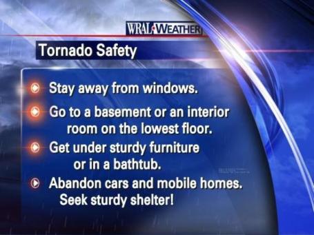
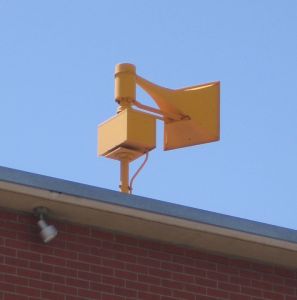
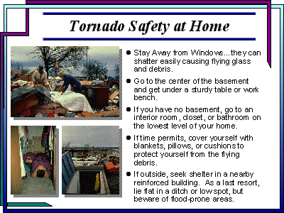 Gentle Reminders. I can't believe I'm already launching into tornado-mode. Good grief. No rest for the weather-weary. You've heard it before: under the stairs in your basement (under a table or work bench) offers the greatest protection, NOT the southwest corner. If you don't have a basement try to seek shelter near the center of your home. The smaller the room, the better. The more walls between you and the tornado, the better. People have survived by hiding in closets, bathrooms, even bathtubs. One woman recently told me she has her kids put on football helmets, which isn't a bad idea. Hopefully it won't come to this, but it might be good to (calmly) review tornado safety tips with your kids (and significant other). It always pays to be prepared.
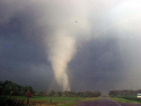
Good Timing. Next week is Severe Weather Awareness Week in Minnesota. Time to review tornado tips, which you can find here. From the local NWS office in Chanhassen: "Last year, Minnesota saw 113 tornadoes, leading the nation. This was the first year ever that Minnesota had the most tornadoes in the United States. The previous record for tornadoes in a year in Minnesota was 74, which occurred in 2001. Four of the 113 tornadoes were rated EF-4. By far, the worst day of the year was June 17, when 48 tornadoes touched down across Minnesota, eclipsing the daily record that had been 27 on June 16, 1992. Three people died in tornadoes last year, all on June 17th. 45 of the 46 tornado injuries in Minnesota last year happened on June 17th. Wisconsin had 46 tornadoes last year, for its second highest total ever. The record for tornadoes in a year in Wisconsin still stands at 62, which occurred in 2005. Five tornadoes were rated EF-2, and there were no stronger tornadoes in Wisconsin last year. There were no fatalities in the state last year, but 22 people were injured in tornadoes in 2010 across Wisconsin.
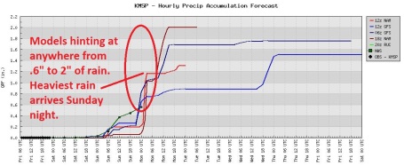
April Showers. Models are truly all over the map, the NWS going with about .6", but some of the GFS runs are suggesting as much as 1-2" rain, with the best chance of enormous puddles coming Sunday night into Monday morning. The impact on Minnesota's ongoing flood scenario is still unclear, but there's little doubt all this heavy rain (falling on saturated/frozen ground) will prolong crests on area rivers.
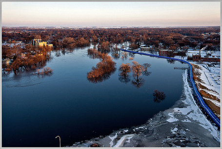
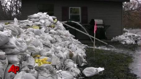 Midwest Flood Fight: Fargo Pushes Back Against The Red. The Red River is predicted to crest this weekend, within a foot or so of the all-time record set in 2009. Here's an update from AP and USA Today: "FARGO, N.D. (AP) — If any city is entitled to confidence that it can handle a major spring flood, it's this one With the Red River lapping at Fargo's doorstep for the third straight year, the local newspaper even wondered if overconfidence was becoming a problem when volunteer turnout was light this week as sandbagging began. "Urgency missing in fight," the Forum's top headline fretted. It was a fleeting moment of concern in Fargo, a city of 105,000 perched on the border of North Dakota and Minnesota that has used guile, gumption and innovation to put itself beyond the worst the Red can offer. Despite a National Weather Service outlook that calls for a crest range between 39 and 40 feet, potentially one of the top five flood levels on record, Fargo feels ready for the top that may arrive late Sunday. The city opened its sandbag warehouse on Valentine's Day, its earliest start ever, and 12,600 volunteers filled about 2.5 million bags in three weeks. And though sandbagging started slowly in neighboring Moorhead, Minn., Fargo itself started strong a day later and was on pace to finish on Thursday, ahead of schedule."
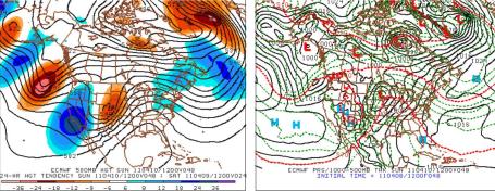
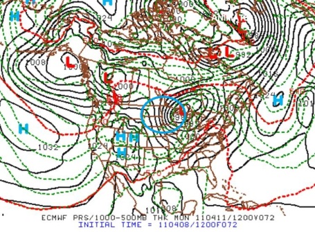
Sunday Scenario. Here is the ECMWF (European) model, valid Sunday morning around breakfasttime. I know this is hard to read, but it shows an intense area of low pressure over southwestern Minnesota, with a warm front draped over southern Minnesota. That front should become the focal point for strong to potentially severe storms from Saturday night into Sunday evening.
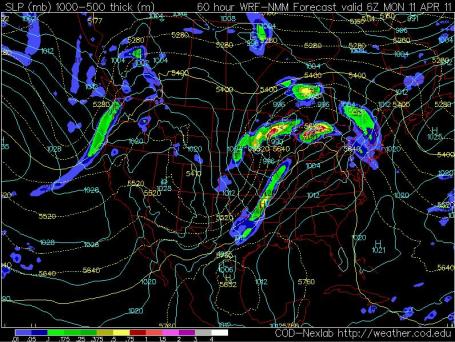
Sunday Night Soaker? The 18z NAM model depicts a shield of moderate rain over much of central/southern MInnesota and northern Wisconsin Sunday night as the center of low pressure tracks over southern MN into Wisconsin - strong winds whipping up on the backside of the storm. Plan on a slow (wet) Monday morning commute. The map above is valid midnight Sunday night.
Blustery Monday. The weather map valid Monday morning shows a very tight pressure gradient, implying sustained winds in the 20-40 mph. range with some higher gusts. I expect the local NWS to issue a wind advisory from late Sunday night into Monday.
End To The Snow Season? I sure hope so, otherwise my neighbors will pick up their pitchforks and it will all end badly (for me). I suspect we've seen the last of the accumulating snow for the winter season. I can't believe I even have to say this, but (in theory) it can snow into the 3rd week of May, at least flurries. Cooler weather returns the latter half of next week, but I don't see any slush falling from the sky looking out at least 2 weeks. During a typical April 3.1" snow falls at MSP. So far this month: a trace of snow. 84.7" for the winter season. That's quite enough, thank you very much.


TODAY: Mostly cloudy and mild. Much of the day should be dry. Winds: SE 10-20. High: 68
SATURDAY NIGHT: Humid with a growing chance of showers and T-storms, some heavy. Low: 57
SUNDAY: Some hazy sun possible, sticky with T-storms likely, some severe. High: 76
SUNDAY NIGHT: Storms give way to rain, heavy at times. Winds increase. Low: 49
MONDAY: Very windy, turning cooler. Heavy rain early tapers to showers. High: 59 (falling)
TUESDAY: Sun returns, still mild. Low; 42. High: 65
WEDNESDAY: Sun north, showers south. Low: 45. High: 56
THURSDAY: Patchy clouds, rain probably stays south. Low: 40. High: 53
FRIDAY: Partly sunny, close to "average" temperatures. Low: 38. High: 56
Cue The Sirens
No rest for the weary. From slush to tornado sirens in 2.5 weeks. That has to be a new record. Sneak outside today: the drier (nicer day) of the weekend to clean up the yard, hop on your dusty bike, reintroduce yourself to stunned neighbors emerging from hibernation.
"The Red Winged Black Birds are back! They came screeching in and are taking up their posts guarding the wetlands," says my most reliable weather spotter, Sharon Bertrand in Mendota Heights. Welcome to an instant spring: near 70 today, 76 Sunday, with a dew point rising above 60. Throw in instability, strong "wind shear", winds changing speed/direction with altitude, and you have a recipe for severe storms. Hail, strong winds, even a few isolated tornadoes can't be ruled out tomorrow (best chance south/east of the Twin Cities Sunday PM hours). I wouldn't change my Sunday plans, just stay alert & connected (one of the best ways to get the latest warnings is to sign up for free alerts on your cell phone). Don't rely on the sirens; they were never meant to be heard indoors.
Models print out over 1" rain by Monday, which may prolong crests on area rivers. Welcome to spring, with all the unpleasant side effects.
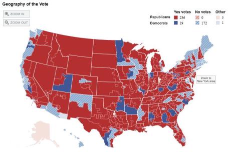 House Votes To Bar EPA From Regulating Industrial Emissions. An update from the New York Times: "WASHINGTON — The House voted 255 to 172 on Thursday to halt the Obama administration’s program to regulate industrial air emissions linked to climate change, delivering a rebuke to a central tenet of the president’s energy and environmental policy. Nineteen Democrats joined in approving a bill that, were it to become law, would bar the Environmental Protection Agency from acting to limit emissions of carbon dioxide and other greenhouse gases that the agency has declared a threat to human health and the environment. The measure would also nullify a 2007 Supreme Court ruling that gave the agency the authority to issue regulations to curb those emissions. The bill stands little chance of becoming law because a similar measure voted on in the Senate on Wednesday came up 10 votes short of the 60 votes needed to avert a filibuster. President Obamathis week threatened to veto any measure that would hinder the administration’s efforts to restrict emissions that scientists say are warming the atmosphere and leading to potentially devastating changes in the global climate."
No comments:
Post a Comment