TODAY: Some sun through increasing clouds. Winds: E 10-15. High: 68
TUESDAY NIGHT: Showers and T-showers expected over far southern MN. Low: 52
WEDNESDAY: Rain showers south (including metro area), bright sun northern MN. High: 66
THURSDAY: Damp start, then blue sky, refreshing breeze. Low: 48. High: 65
FRIDAY: Sun fades behind high clouds, still cooler than average. Low: 47. High: 64
SATURDAY: Gray start? Getting sunnier. Low: 50. High: near 70
SUNDAY: Mostly cloudy with showers, possible T-storms. Low: 58. High: 72
MONDAY: T-storms, some strong/severe? Low: 64. High: near 80
* 2011 is already the 11th worst season in USA history for tornadoes. May is typically the peak month for tornadoes nationwide.
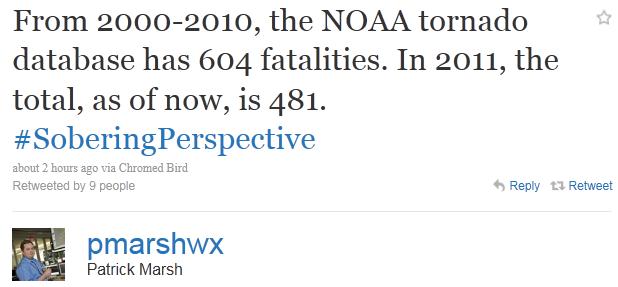
* 2011: most tornado deaths since 1953.
* Only 8 tornadoes have produced a larger loss of life than the Joplin, Missouri twister.
* EF-4: Joplin, Missouri tornado was a rare EF-4, according to NWS damage assessment teams on the scene.
* 116 deaths in Joplin, Missouri as of 10 pm Monday night.
* 1,000+ people have been injured or hospitalized from the tornado.
* Over 2,000 homes and businesses have been damaged or destroyed in Joplin.

* There was an estimated 20 minute warning, from when the first NWS Tornado Warning was issued to when the tornado entered the city of Joplin.
* 17 minutes from when Joplin emergency manager turned on the siren and the tornado struck.
_________________________________________________
Sunday Tornado in Minneapolis: "The tornado ripped a nearly five-mile path from suburban St. Louis Park, where it hit a condo complex and two businesses, through north Minneapolis, into Fridley. The National Weather Service said Monday that the tornado was either a strong EF1 or possibly an EF2, and was on the ground for 6.25 miles in Hennepin County plus an additional 8 miles across Anoka and Ramsey counties. An EF1 tornado has speeds of up to 109 mph. An EF2 has speeds of 110-137 mph." (courtesy: Fargo/Moorhead InForum - complete story below).
* Fox News has more on Sunday's Minneapolis tornado here.

Best mobile app to get tornado warnings (or any kind of warning, watch or advisory for the locations you care about or your current GPS location?) Details below.

Tornado Deaths in The USA. The Weather Channel's Dr. Greg Forbes (fellow Penn State grad) has an amazing post about how this year's deadly tornado count compares with previous years: "TWC Severe Weather Expert, Dr. Greg Forbes (Find him on Facebook)
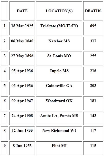
In fact, there have been only 8 tornadoes documented in U.S. history that have claimed more lives than the Joplin, Mo. tornado!
Top 10 deadliest tornadoes
- Mar. 18, 1925 (Tri-State Tornado): 695
- May 6, 1840 (Natchez, Miss.): 317
- May 27, 1896 (St. Louis, Mo.): 255
- Apr. 5, 1936 (Tupelo, Miss.): 216
- Apr. 6, 1936 (Gainesville, Ga.): 203
- Apr. 9, 1947 (Woodward, Okla.): 181
- Apr. 24, 1908 (Amite, La., Purvis, Miss.): 143
- Jun. 12, 1899 (New Richmond, Wisc.): 117
- May 22, 2011 (Joplin, Mo.): 116
- Jun. 8, 1953 (Flint, Mich.): 115
According to preliminary stats from NOAA's Storm Prediction Center, we're now pushing toward 500 U.S. tornado deaths in 2011. The last year we saw as many as 400 tornado fatalities was 1953 (519 fatalities)!
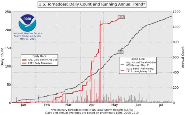
Off The Charts. According to SPC there have been 1,118 (preliminary) tornadoes, nearly twice as many as average (659), to date.
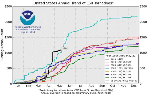
Tornado Trends. The 5-year average is the gray line, 2011 is the black line (1,118 and counting). Data from SPC.
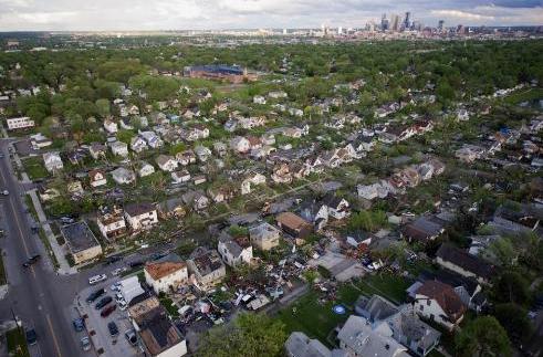
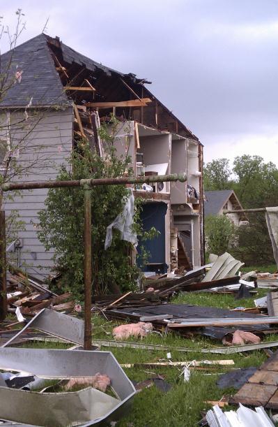
Minneapolis Tornado Update. The Star Tribune has the latest on Sunday's tornado, which I still suspect will wind up being classified as an EF-2, based on damage reports and the width of the tornado: "Sunday's tornado was the first to strike within the city of Minneapolis since a minor twister in south Minneapolis on Aug. 19, 2009. Sunday's damage appeared consistent with tornadoes rated EF2, which carry winds of 111 to 135 miles per hour. Only 10.7 percent of U.S. tornadoes are rated EF2, and only about 4 percent are stronger. On Monday, damage assessment teams from the National Weather Service will visit dozens of damage scenes and make a final pronouncement on the length, strength and number of tornadoes."
* Second Tornado-Related Death Reported In Minneapolis. Fargo/Moorhead's InForum has the latest: "A man using a chainsaw to help clear a tree from a blocked roadway collapsed and died, his family said Monday, a second confirmed death related to a tornado that tore through Minneapolis over the weekend, injuring dozens of people and destroying hundreds of homes. Family and friends of Rob MacIntyre said the 53-year-old collapsed about 6 p.m. Sunday, not long after helping clear the tree that was toppled by the tornado. Dave Soderstrom, who had been helping MacIntyre, said paramedics didn't arrive immediately because they had to travel on foot through impassable streets. "They worked on him for 45 minutes," Soderstrom said. "They tried everything multiple times. He just didn't revive. He didn't react to anything." MacIntyre was president of the Iowa-based Raptor Resource Project, the organization behind an "Eagle Cam" in Decorah that has attracted worldwide attention over the Internet. The group issued a statement mourning his death. Residents seemed to be in shock Monday as they emerged from their homes and saw toppled trees, missing garages, roofs on the ground and dangling power lines, all left behind after Sunday's tornado, which killed two people _ including MacIntyre _ and left 29 injured. The tornado ripped a nearly five-mile path from suburban St. Louis Park, where it hit a condo complex and two businesses, through north Minneapolis, into Fridley. The National Weather Service said Monday that the tornado was either a strong EF1 or possibly an EF2, and was on the ground for 6.25 miles in Hennepin County plus an additional 8 miles across Anoka and Ramsey counties. An EF1 tornado has speeds of up to 109 mph. An EF2 has speeds of 110-137 mph.
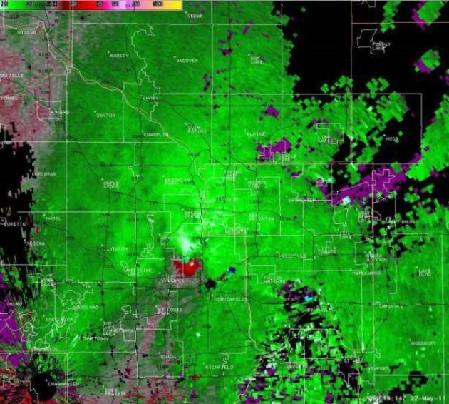
Minneapolis "Couplet". This is what the NWS Doppler radar (velocity field) was showing Sunday afternoon, evidence of violent rotation over St. Louis Park. A tornado warning was issued before confirmation of a tornado touchdown (at 100 and 394). Source: National Weather Service.

Hook Echo. Here is another NWS screen-shot from Sunday's Minneapolis tornado - showing a classic "hook echo" over western Hennepin County.
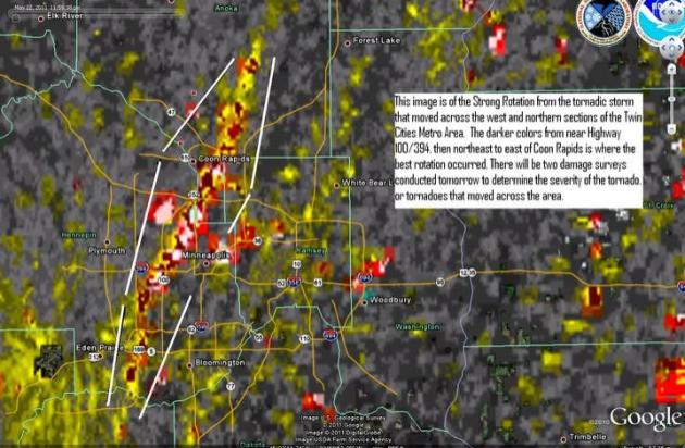
Tornadic Post Mortem. From the local National Weather Service's Facebook page: "An image of the strong rotation that moved across the Metro Area."
America's Deadliest Tornadoes. According to SPC this will probably be the 10th deadliest tornado in U.S. history, possibly the most fatalities from a single tornado since 117 people died in New Richmond, Wisconsin in 1899.
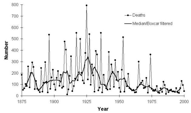
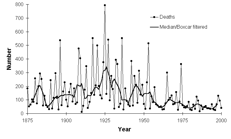
Tornado Deaths In The USA. 1925 was a horrific year, 800 tornado-related fatalities in the USA. Since then the trend has been downward, due to a streamlined National Weather Service warning system, well-trained severe storm spotters, radar (Doppler radar came online in the 1990s, allowing us to detect the rotating thunderstorms most likely to spawn tornadoes), and overall public knowledge and respect for these fearsome weather events. Graph courtesy of NSSL in Norman, Oklahoma.
* Less than 1% of all tornadoes will ever reach EF-4 or EF-5 strength, with sustained winds close to 200 mph. The Joplin, Missouri tornado was 1/2 to 1 mile wide, on the ground for 6-8 miles.
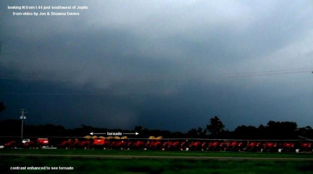
Unfathomable. The May 22, 2011 Joplin Tornado. Jon Davies is a PhD researcher and severe storm expert. He got a first-hand look at the tornado that tore through Joplin, a 1/2 to 1 mile wide "wedge" tornado. it was so wide (and wrapped in rain and hail) that many local residents may not have even realized that a super-torando was approaching. This is a real problem for these large wedges: they don't fit the typical stereotype of a "funnel". It appears that the entire thunderstorm has descended to the ground - strong rotation and large hail one of the few tip-offs that this was no ordinary storm. From Davies' blog: "Shawna and I drove through downtown Joplin minutes before the tornado hit. Sirens were going, but we could not see the tornado, and many people were out and about seemingly unaware or unconcerned. We had been following this storm complex for a couple hours without observing any tornadoes, and though we were a little nervous, we weren't anticipating anything of the magnitude that buried Joplin around 5:45 pm CDT. We blasted southwest on Interstate 44 to circumvent the approaching mesocyclone on radar that suddenly appeared very strong. As we looked to the north through the trees we caught a brief glimpse of the hard-to-see tornado (see images above, the second enhanced to make the tornado more visible). It was so large and the visibility so poor, that this may have had something to do with why so many people were killed."
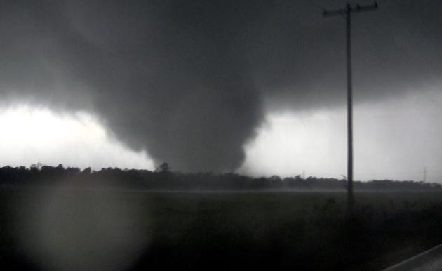
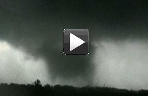
Joplin Tornado. From The Atlantic: "This frame grab from video shows a massive tornado on Sunday, May 22, 2011, outside Joplin, Missouri." (AP Photo/tornadovideo.net)
PUBLIC INFORMATION STATEMENT
NATIONAL WEATHER SERVICE SPRINGFIELD MO
938 PM CDT MON MAY 23 2011

..JOPLIN TORNADO GIVEN A PRELIMINARY HIGH END EF-4 RATING

* DATE...22 MAY 2011
* BEGIN LOCATION...APPROXIMATELY 3 MILES SOUTHWEST OF JOPLIN
* END LOCATION...1 MILE SOUTHEAST OF DUQUESNE
* ESTIMATED BEGIN TIME...541 PM
* ESTIMATED END TIME...550 PM
* MAXIMUM EF-SCALE RATING...EF-4
* ESTIMATED MAXIMUM WIND SPEED...190-198 MPH
* ESTIMATED PATH WIDTH...3/4 OF A MILE
* PATH LENGTH...7 MILES
* FATALITIES...116 REPORTED AS OF 3 PM MONDAY
* INJURIES...400 REPORTED AS OF 3 PM MONDAY
* BEGIN LAT/LON...37.06 N / 94.57 W
* END LAT/LON...37.06 N / 94.39 W

NATIONAL WEATHER SERVICE SURVEY TEAMS RATED THE TORNADO THAT KILLED
OVER 100 PEOPLE IN AND AROUND JOPLIN AS A HIGH END EF-4 TORNADO.
BASED UPON SURVEYS COMPLETED TODAY...MAXIMUM WINDS WERE ESTIMATED
BETWEEN 190 AND 198 MPH. THE TORNADO HAD A MAXIMUM WIDTH OF 3/4 TO
ONE MILE.
* More from the National Weather Service here.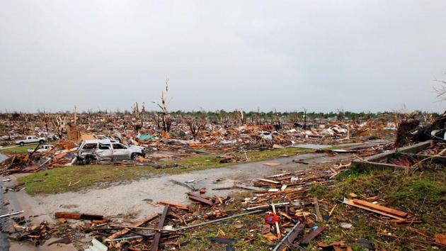
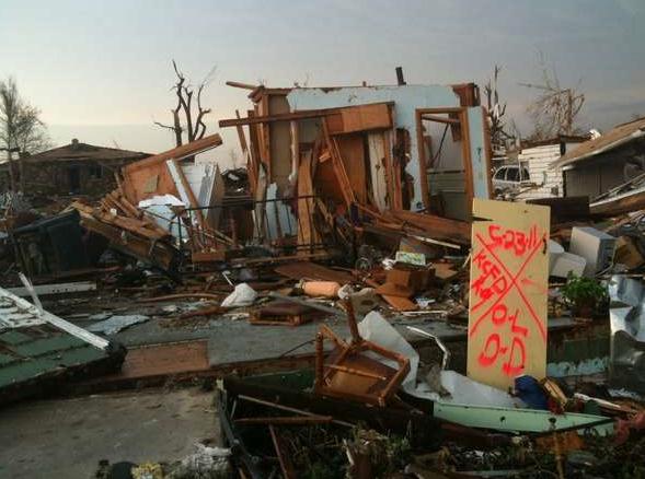
Atmospheric Bomb. Words can't adquately describe a scene like this. The Atlantic has an amazing collection of photos from Joplin. They capture the horror of this storm better than anything I've seen yet: "An entire neighborhood lay in ruin after a devastating tornado hit Joplin, Missouri, on May 23, 2011." (Reuters/Mike Stone)
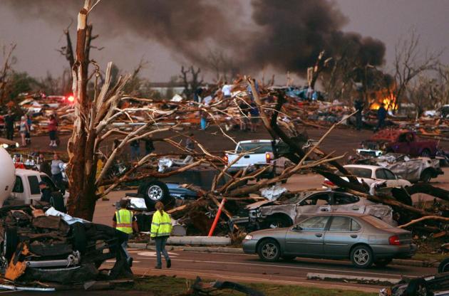
Armageddon. Much of Joplin looked like a war-zone on Monday, one day after the deadliest single tornado since 1899: "Emergency personnel walk through a neighborhood severely damaged by a tornado near the Joplin Regional Medical Center in Joplin, Missouri, on Sunday, May 22, 2011." (AP Photo/Mark Schiefelbein) Courtesy of The Atlantic.
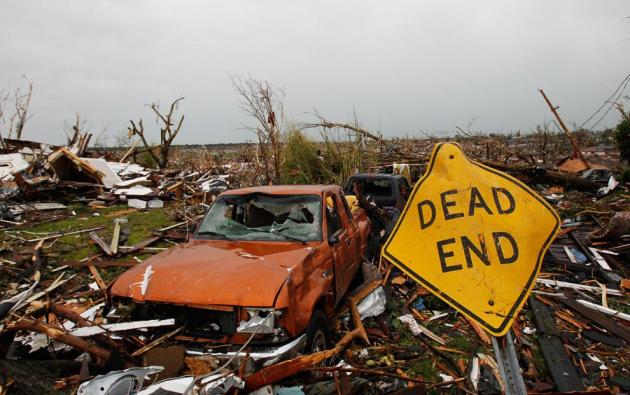
Dead End. From the same awe-inspiring series of photos and stories in The Atlantic: "A sign lays among the ruins after a devastating tornado hit Joplin, Missouri May 23, 2011."
"I'm Alive!" Text Message Saves Missouri Tornado Victim's Life. Here's an amazing story from the U.K.'s Daily Mail: "A Missouri man was pulled from the rubble of the deadly tornado after he sent a text message to his best friend calling for help. The man became buried under debris when the powerful tornado went straight through the centre of Joplin. He sent a text message to his best friend telling him that he was alive and giving his location. Cheers and applause rang out as the young man was pulled from the rubble by emergency workers. ‘Yeah he’s my friend, my best friend,’ said the man who received the text message after his friend emerged from the mound of debris."
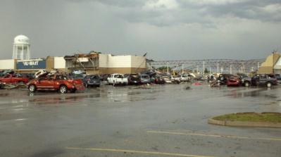
Joplin Walmart. There's virtually nothing left of the Walmart in downtown Joplin. Photo courtesy of Twitpic.
Home Depot In Joplin. From Twitpic: "What is left of Home Depot at 20th and Range Line in Joplin."
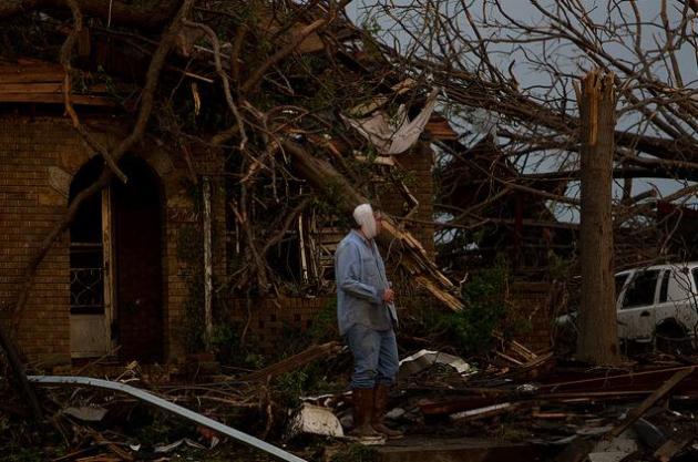
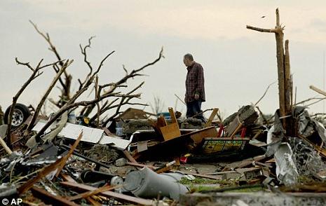
Dazed. A photo from Flickr: "Man with bandaged head surveys damage outside of his home, Joplin Missouri."
Flying J Truck Stop in Joplin, Missouri. Thanks to Severe Studios for passing along this photo.
Pepsi Bottling Plant. Thanks to WeatherNation meteorologist Bryan Karrick for passing this on. A friend of his, Betsy Larkin, once worked for a Pepsi operation here in the Twin Cities - these were sent to her. Unbelievable.
Alien Landscape. Trees stripped of branches, in many cases snapped in half. Homes scoured all the way down to foundation: this was, in all probability, an EF-4, possibly a rare EF-5 tornado. Photo courtesy of Gannett's News Leader.
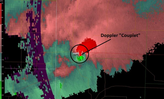
Joplin "Couplet". NWS Doppler showed evidence of extreme rotation in the vicinity of Joplin late Sunday - the tell-tale signs of a "supercell" thunderstorm capable of a large and violent tornado.
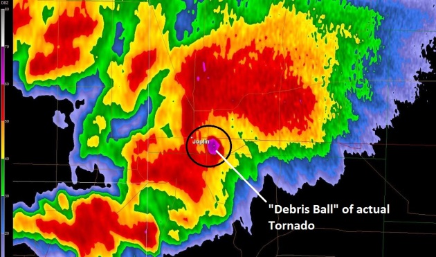
"Debris Ball." The Joplin tornado was so large (approximately 1 mile wide at times) that the Doppler energy beam showed actual debris being kicked up by the tornado (the bright purple spot). This was no ordinary, garden-variety tornado,

Panorama of Horrors. I think it's hard to look at a photo or even a video and get a true sense of scope of devastation from a violent (mile-wide) tornado. This is as close as I've come to finding a tool that shows the extent of the damage, as far as the eye can see in every direction.
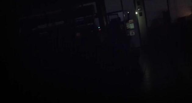
A Surreal Sight. Emergency responders had to use flashlights and the headlights of vehicles to search for survivors in the aftermath of the Joplin tornado. Image courtesy of the New York Times.
Super-Tornado. From Jeff Master's Wunderblog: The incredibly violent tornado season of 2011 struck another sickening blow last night, when a violent tornado carved a ½ – ¾ mile-wide path of devastation through Joplin, Missouri. At least 89 people died, hundreds were injured, and huge sections of the town virtually obliterated. Damage from the tornado is so severe that pavement was ripped from the ground, which is characteristic of a top-end EF-5 tornado with winds in excess of 200 mph. This was almost certainly a least an EF-4 tornado with winds over 166 mph, and the level of damage is so extreme that this is likely to surpass last month's Tuscaloosa-Birmingham tornado as the costliest tornado of all-time.
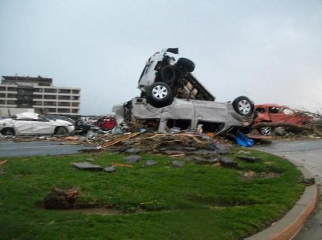
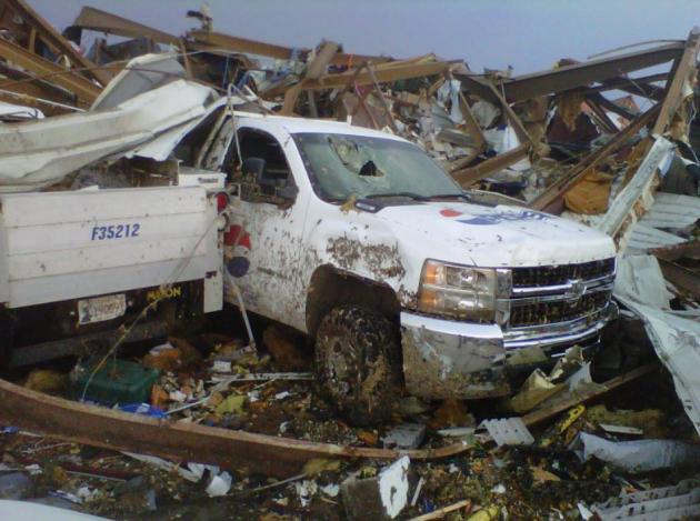
Photo Credit: Cars stacked on top of each other in front of the heavily damaged St. Johns Regional Medical Center after the May 22, 2011 tornado in Joplin, Missouri. Note the pavement ripped up from the road and piled in front of the cars. Tornadoes powerful enough to rip up pavement are frequently classified as EF-5 with winds in excess of 200 mph. Image credit: Chris McCrillis, posted to Twitter. Information courtesy of Jeff Masters and his Wunderblog.
GOES-13 Satellite Video Close-Up Of Deadly Joplin, Missouri Tornado. Here's an article from NASA: "The Geostationary Operational Environmental Satellite called GOES-13 provides forecasters with continuous visible and infrared imagery of weather systems across the U.S. and a new movie from the NASA GOES project gives a close up of the storm the created the monster tornado that devastated Joplin, Missouri yesterday. An animation of imagery from the GOES-13 satellite was created from images taken before, during and after the time the massive tornado touched down in Joplin, Missouri on Sunday, May 22. The nominal time of the tornado was 5:30 p.m. CDT, which is 2230 UTC. Meteorologist Dennis Chesters of the NASA GOES Project at NASA's Goddard Space Flight Center in Greenbelt Md. created the animation from GOES imagery to show the progression of the storm system. The animation of visible imagery begins on May 22 at 17:44 UTC (12:44 p.m. CDT). In the video, Chesters identified the location of Joplin so viewers can see the line of thunderstorms that generated the tornado as the animation continues. "The convection above a tornado normally penetrates to the cloud tops and makes visible ripples about 10 minutes after the tornado hits the ground," Chesters said. The animation ends on May 23 at 00:15 UTC (7:15 p.m. CDT, May 22, 2011). According to reports from the Joplin Globe on-line, the tornado was one half-mile wide when it struck Joplin and expanded to three-quarters of a mile wide before dissipating."

May 2011 Tornado Statistics From NOAA:
The May 22, Joplin, Missouri tornado, with an estimated 89 fatalities, is the highest death toll from a single tornado since the 1953 tornado that hit Worcester, Mass., which caused 90 fatalities on June 9, 1953.
- If the fatalities exceed 90, the Joplin tornado will become the deadliest since Flint, Michigan (116 fatalities - June 8, 1953).
* The record number of tornadoes during the month of May was 542 tornadoes set in May 2003.
- The average number of tornadoes for the month of May during the past decade is 298.
- May is historically the most active month for tornadoes.
- NWS’s preliminary estimate is that there have been approximately 1,000 tornadoes so far this year.
- The previous yearly record number of tornadoes was set in 2004 with 1,817.
- The overall yearly average number of tornadoes for the past decade is 1,274.
First Person Video Of Joplin Tornado. This guy did the right thing - he sought shelter in a refrigerated storage room or freezer (hard to tell) with scores of other terrified locals. He kept his (iPhone video) rolling for nearly 6 minutes. You can hear the roar of the tornado about 2:30 into the video. This YouTube clip, more than anything I've ever seen, captures the horror of a tornado - the hysteria, sobbing, pleading, the shear terror. Rated PG for mild profanity.
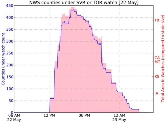
Widespread Severe Event. Here's an amazing statistic from the Iowa Environmental Mesonet: "The weather was severe on Sunday over a large portion of the country. The featured chart presents the combined number of counties under either a tornado or severe thunderstorm watch at a given time. The total combined area of those counties is presented as well. At 3:45 PM yesterday, 445 counties were in watches covering an area larger than Texas! According the IEM data, the largest number of counties under watch in the past 6 years was 785 during the recent outbreak over the south on 27 April."
Amateur vid collection of Joplin tor and aftermath from NYT
http://video.nytimes.com/video/2011/05/23/us/100000000831018/timescast--massive-twister-in-missouri.html?smid=tw-nytimes
Joplin pix/video
http://mashable.com/2011/05/23/joplin-missouri-tornado/
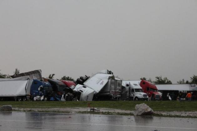
Flipped semis near Joplin
http://www.youtube.com/watch?v=-Fi-Uw8bgSA
Joplin damage
http://www.youtube.com/watch?v=CSryN8LlIks
http://www.youtube.com/watch?v=Sz3fU71ufCw
http://www.youtube.com/watch?v=5H8mhr4o4Tw
IA Tornado on Sunday
http://www.youtube.com/watch?v=bdJX7EPU4BQ
Brief Oklahoma Tornado on Sunday
http://www.youtube.com/watch?v=_7hUFce0ygc
http://www.youtube.com/watch?v=zjbd_Qnd7gY
LaCrosse, WI damage
http://www.youtube.com/watch?v=vD2s116f-mc
* Thanks to WeatherNation meteorologist Jason Parkin for the links above.http://video.nytimes.com/video/2011/05/23/us/100000000831018/timescast--massive-twister-in-missouri.html?smid=tw-nytimes
Joplin pix/video
http://mashable.com/2011/05/23/joplin-missouri-tornado/
Flipped semis near Joplin
http://www.youtube.com/watch?v=-Fi-Uw8bgSA
Joplin damage
http://www.youtube.com/watch?v=CSryN8LlIks
http://www.youtube.com/watch?v=Sz3fU71ufCw
http://www.youtube.com/watch?v=5H8mhr4o4Tw
IA Tornado on Sunday
http://www.youtube.com/watch?v=bdJX7EPU4BQ
Brief Oklahoma Tornado on Sunday
http://www.youtube.com/watch?v=_7hUFce0ygc
http://www.youtube.com/watch?v=zjbd_Qnd7gY
LaCrosse, WI damage
http://www.youtube.com/watch?v=vD2s116f-mc

Twisters Were Alabama's Costliest Disaster. USA Today has the story: "MONTGOMERY, Ala. — Alabama's cleanup after its April 27 tornadoes struck represents the state's greatest rebuilding effort since the end of the Civil War, disaster experts say. The twisters were part of a burst of 305 tornadoes that ripped the South over three days, killing at least 326 people. According to the National Weather Service, at least 24 killer tornadoes struck Arkansas, Mississippi, Alabama, Georgia, Tennessee and Virginia. Alabama suffered the most destruction — 238 deaths and insured losses estimated at $2.45 billion to $4.2 billion. The Federal Emergency Management Agency has taken 70,120 applications for assistance in Alabama as of last week, said Rita Egan, a FEMA spokeswoman. The agency has approved about $39 million, $28 million of it for temporary housing, she said. In the short-term, the recovery effort will boost Alabama's economy as people try to rebuild their lives, but in the long run the state will suffer, said Jeff Bates, student services coordinator at Auburn Montgomery's School of Business."
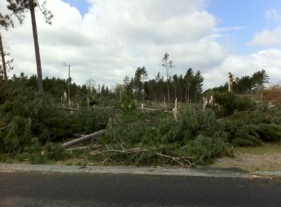
Wisconsin Tornadoes. Wisconsin got hit very hard on Sunday. Here's a post from Jeff Last and Twitpic: "Thousands of trees down along path of the Wood-Portage Co tornado."
Another Major Outbreak? SPC is predicting a "moderate threat" of severe storms later today across the central and southern Plains, from Dallas northward to Kansas City. I expect as many as 40-80 additional tornadoes by midnight tonight.
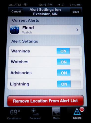
My-Cast Weather Radar App. People ask me what the best app is for getting storm advisories, watches and warnings. I've downloaded just about all of them and taken them for a test-drive, but the best (in my humble, subjective opinion) is "My-Cast Weather Radar." You can not only see radar and warning maps, but you get an automatic alert when a warning is issued for any locations you care about, including your CURRENT GPS LOCATION. Not only will you get the tornado warning you need within a fraction of a second of when it's issued by the local NWS office, you can get lightning alerts; be notified when lightning strikes within a 10 mile radius of the location you care about. Great for the lake or the ballpark. Full disclosure: I sold Digital Cyclone (maker of "My-Cast") to Garmin in 2007. For the record I don't get a commission or any kind of spiff - I'm just sharing what I think the best (mobile) solution is for iPhones and Android. Here's more information: "The award-winning My-Cast app delivers comprehensive yet intuitive weather information specifically for the iPhone and iPod Touch. Un-cluttered base maps display animated radar, clouds and StormWatch severe weather alerts allowing effortless interpretation of how the weather affects your day. As you check out the current weather, you may see drifting clouds or falling rain as My-Cast's distinctive weather themes come to life. Whether you are interested in weather for today, tomorrow or next week, My-Cast has you covered. When severe weather strikes, My-Cast transmits the latest alerts direct from the National Weather Service."
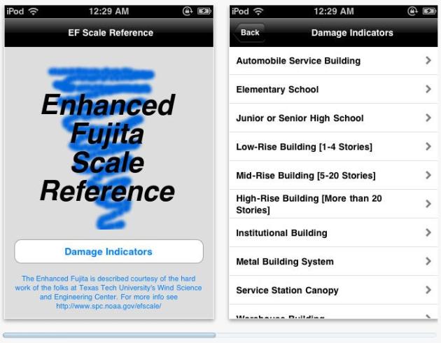
EF Scale. iTunes has an app that delves into the EF (enhanced Fujita) scale of tornado measurement. There is no way to tell whether a tornado was an EF-0, 1, 2, 3, 4 or 5 until National Weather Service teams get into the field to assess the extent of damage. This is an app for Apple devices - not sure if there's an Android or Blackberry version yet. "Interested in tornado and wind damage assessments? Wonder how they rate a tornado from EF0 to EF5 without guessing? This app is the answer!"
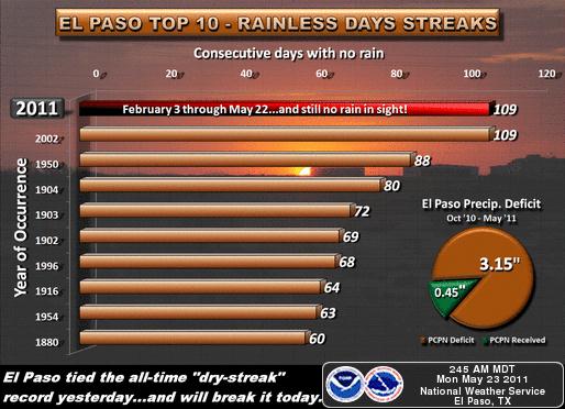
Growing Drought. While the Mississippi floods and much of America dodges monster-tornadoes, the "exceptional" drought continues to worsen across Texas and Louisiana. This graphic from the El Paso National Weather Service puts things into stark perspective: 109 days without a drop of rain.
Next Chance Of Rain. Clouds will increase across the southern half of Minnesota today, a few showers and T-storms may push into far southern MN by evening. The best chance of rain comes Wednesday - but the bulk of the rain (and any severe storms) should pass to our south.
Half-Decent Weekend? Skies should clear Saturday with enough sun for low to mid 70s - most of the day should be dry. Sunday may be a different story as a frontal boundary pushes north, a growing chance of showers and T-storms during the day on Sunday.

Are Our Kids Addicted To Technology? Slate poses the question (the answer, reasurringly, is not as much as you might think): "Last week's PopRx, "Our Overblown Paranoia About the Internet and Teens," received many thoughtful comments and emails from readers, including a few that I wanted to double back on and magnify. First, some readers wondered what, if anything, teen Internet use has to do with medicine. The most obvious way to answer that is to point to the recent report by the American Academy of Pediatrics recommending doctors address social media with their patients and families. But more than that, addressing "nontraditional medical risks" (child development, behaviors, emotional well-being) alongside "traditional" risk (infections or injuries) is a core value of modern pediatrics. Chronic illness could mean diabetes or asthma, but also things like school and conduct problems. We're now adding e-risks to our problem list. Second, readers wanted to know how hours upon hours of Internet exposure impacts a child's development. They're certainly not alone; it's one of the most vexing questions of modern parenthood. No less an authority than New York Times executive editor Bill Keller wrote about this topic recently in a much-blogged-about piece called "The Twitter Trap," which began: "Last week my wife and I told our 13-year-old daughter she could join Facebook. Within a few hours she had accumulated 171 friends, and I felt a little as if I had passed my child a pipe of crystal meth."

Fine Print Blurs Who's In Control of Online Photos. So you upload a photo onto the 'net - you still own it, right? Not so fast. The New York Times has the story: "The agreement between Twitpic and World Entertainment News, said Dan Bailey, a professional photographer from Alaska, provided a solid example of what people have been worried about. “The agreements always make people nervous, but nothing was done with them,” Mr. Bailey said. “But for a company like Twitpic to come along and say that they can sell your photos, that’s unreasonable.” Twitpic did not respond to multiple requests for comment, and neither company has made the details of the agreement public. Mr. Beiny said in an e-mail that the deal covered only the accounts of several hundred celebrities. He declined to comment further. World Entertainment News forged a similar deal this year with Plixi, a smaller online photo service. In an interview with the magazine Amateur Photographer, Mr. Beiny claimed a right to all photographs uploaded to the service. He told the magazine that though World Entertainment News might try to sell “extraordinary” photographs of any kind, its primary interest was celebrities. The deal was terminated when Plixi was acquired by Lockerz, which said it was uncomfortable with the concept."

When The Internet Thinks It Knows You. Google, Facebook, Amazon and other sites have sophisticated algorithms that narrow what you see (content, search results, advertisements, etc) based on "relevance". Some are concerned where that trend may be headed, as outlined in this Op-Ed in the New York Times: "Like the old gatekeepers, the engineers who write the new gatekeeping code have enormous power to determine what we know about the world. But unlike the best of the old gatekeepers, they don’t see themselves as keepers of the public trust. There is no algorithmic equivalent to journalistic ethics. Mark Zuckerberg, Facebook’s chief executive, once told colleagues that “a squirrel dying in your front yard may be more relevant to your interests right now than people dying in Africa.” At Facebook, “relevance” is virtually the sole criterion that determines what users see. Focusing on the most personally relevant news — the squirrel — is a great business strategy. But it leaves us staring at our front yard instead of reading about suffering, genocide and revolution. There’s no going back to the old system of gatekeepers, nor should there be. But if algorithms are taking over the editing function and determining what we see, we need to make sure they weigh variables beyond a narrow “relevance.” They need to show us Afghanistan and Libya as well as Apple and Kanye. Companies that make use of these algorithms must take this curative responsibility far more seriously than they have to date. They need to give us control over what we see — making it clear when they are personalizing, and allowing us to shape and adjust our own filters. We citizens need to uphold our end, too — developing the “filter literacy” needed to use these tools well and demanding content that broadens our horizons even when it’s uncomfortable."
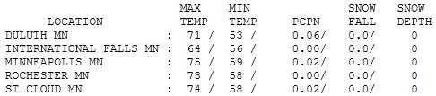

Lukewarm Monday. It was nice having the sun out (without the emergency sirens wailing). There were a few showers, .02" in the Twin Cities and St. Cloud, as much as .15" of rain fell up at Grand Marais. Highs rose into the 70s across much of Minnesota.
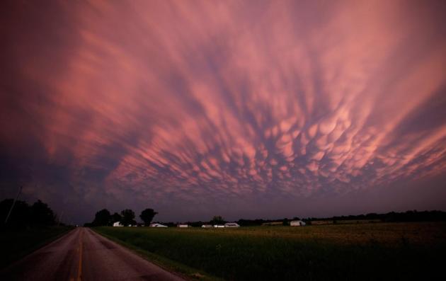
Beauty Amidst The Carnage. "Storm clouds dwarf a farm near Lamar, Missouri, as the sun sets Sunday, May 22, 2011. The storm earlier produced a large tornado moved through much of Joplin, Missouri, damaging a hospital and hundreds of homes and businesses.

A Therapeutic Sight. Thanks to Tricia Frostad for sending me a great photo of crabapple trees in full bloom at the Minnesota Landscape Arboretum.
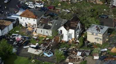
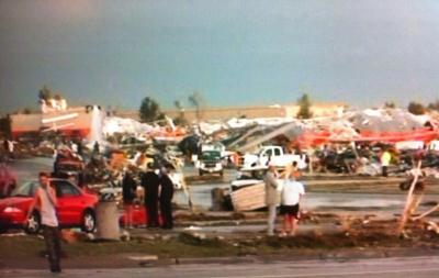
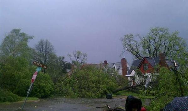
North Minneapolis damage photo courtesy of Fox News.
Local Tornado Alley?
"It sure seems like tornadoes are more likely in the western & northern suburbs Paul. What's up with that?" I hear this one a lot. Since 1960 data from SPC shows a SLIGHT bias toward more tornadoes north/west of MSP. But looking back farther, into the late 1800s, there is NO greater tornado risk in Fridley or Plymouth than in St. Paul or Lakeville. It's a meteorological myth.
Some people gripe when storm warnings interrupt "Oprah" (and it's not their county). "They issue warnings; I never see anything!" The dreaded "Cry Wolf Syndrome". Take watches & warnings seriously. Keep an alert eye on the sky and stay plugged into local media. I tracked down the best app for getting warnings (even lightning alerts) on a smartphone; more on my blog.
I said it weeks ago: this is going to be one of the most severe years for tornadoes in U.S. history. Something has energized the jet stream like never before - 125 mph winds raging 6 miles overhead can increase the potential for violent storms. Is your family ready?
A cool week is on tap, storms passing just south of Minnesota Wednesday, again Friday. A close call. Yes, we may even salvage some weekend sun, especially Saturday. Showers and storms may return by Sunday. 80s arrive the 1st week of June.
Question Swirl Around Climate Change After Rash Of Storms. From Fox in Tampa: "TAMPA - The twister that devastated the small town of Joplin, Missouri, is the nation's deadliest single tornado in almost 60 years, since 1953. A tirade of severe weather hit the Midwest over the weekend. Sixty-eight tornadoes were reported across seven states. Meanwhile, Alabama and other parts of the south are hanging on after April's deadly twisters. The violent weather raises the stormy debate over global warming. "Events of the century, storms of the century are now happening every year," said Phil Compton, field organizer for environmental group Sierra Club. Compton believes there's nothing left to question. "It is absolutely hotter," said Compton. "What happens to all that energy? The energy is stored in the atmosphere and it's expressed in stronger winds. It's expressed in stronger rainfall." But those on the other side of the global warming debate say what's happening is merely cyclical. The National Oceanic and Atmospheric Administration (NOAA) finds no link between the tornado outbreaks and climate change. "I always say it's normal to be abnormal," explains FOX 13 Chief Meteorologist Paul Dellegatto. "You're going to have years when there's going to be a lot of activity."

A City Plans For A Warm Long-Term Forecast. I was in Chicago in 1995 when over 800 people died from extreme heat and humidity in the span of 2 days. Local media referred to this spike in heat as a "heat storm" - it came on suddenly, the combination of 106 degree heat and 81 degree dew points making it feel like 125 F. Here's an article from the New York Times: "CHICAGO — The Windy City is preparing for a heat wave — a permanent one. Climate scientists have told city planners that based on current trends, Chicago will feel more like Baton Rouge than a Northern metropolis before the end of this century. So, Chicago is getting ready for a wetter, steamier future. Public alleyways are being repaved with materials that are permeable to water. The white oak, the state tree of Illinois, has been banned from city planting lists, and swamp oaks and sweet gum trees from the South have been given new priority. Thermal radar is being used to map the city’s hottest spots, which are then targets for pavement removal and the addition of vegetation to roofs. And air-conditioners are being considered for all 750 public schools, which until now have been heated but rarely cooled. “Cities adapt or they go away,” said Aaron N. Durnbaugh, deputy commissioner of Chicago’s Department of Environment. “Climate change is happening in both real and dramatic ways, but also in slow, pervasive ways. We can handle it, but we do need to acknowledge it. We are on a 50-year cycle, but we need to get going.” Across America and in Congress, the very existence of climate change continues to be challenged — especially by conservatives. The skeptics are supported by constituents wary of science and concerned about the economic impacts of stronger regulation. Yet even as the debate rages on, city and state planners are beginning to prepare."
It's Time To Put A Price On Carbon, NRC Says. Science News has the story: “Climate change is occurring, is very likely caused by human activities, and poses significant risks for a broad range of human and natural systems.” As such, “it is imprudent to delay actions that at least begin the process of substantially reducing emissions [of greenhouse gases].” So begins a May 12 report by the National Research Council. It didn’t get a lot of press play in the past week, perhaps because its 144 pages don’t say anything readers might not have expected this august body to have proclaimed years ago. But that shouldn’t diminish the significance of this report, its authors contend. A lot has happened since 2009, when Congress first requested advice from NRC on whether to take action on climate — and if so, on what type of action. First, there was the Climate-gate controversy (where some critics read hacked emails by climate scientists like tea leaves to glean the political intent of those researchers). Then there was the inability of world leaders to craft a new and binding treaty to control the release of climate-altering pollutants. Finally, there was that brouhaha — and embarrassing retraction by the IPCC — over the science organization’s acceptance of unvetted claims about the extent of glacier melting in the Himalayas. These events “left a lot of people confused over what to think about climate change,” notes Stephen Seidel, a vice president and climate-policy analyst at the Pew Center on Global Climate Change. The fact that the new NRC report now concludes that the imperative to act on climate is as strong as ever proves to be a powerful statement, he says, and one that legislators are likely to take seriously. Whether they’ll act on it: That’s another issue."
Natural Gas, Coal And Climate. There are no quick, easy fixes in our attempt to wean ourselves off of Saudi crude, as documented in this story in the Huffington Post: "Recent research has shown that over the next few decades an effective U.S. climate policy to significantly reduce greenhouse gas emissions would rely on extensive reductions in energy use and substitution of natural gas for coal in power generation. The second pathway -- gas-for-coal -- is premised on the fact that natural gas, when combusted, produces 50 percent lower CO2 emissions than coal. A recent paper by Cornell Professor Robert Howarth and others in Climatic Change Letters calls the gas-for-coal solution into serious question, suggesting that natural gas power generation is twice as greenhouse gas (GHG) intensive as coal. Howarth bases this conclusion in part on his assessment of methane leakage in the production stages of natural gas, with a specific focus on new methods to produce unconventional shale gas. Natural gas is primarily methane. There are methane leakages at different stages of the production process, as well as CO2 emissions when natural gas is burned to generate electricity. Methane is a powerful GHG but, unlike CO2, which resides in the atmosphere for over a century, methane lives in the atmosphere for around a decade. The Howarth study raises some legitimate questions about the uncertainties surrounding associated estimates of methane emissions -- but Howarth's conclusions depend on a couple of unsound assumptions."

Education Is Key To Fighting Climate Change. The Ithaca Journal had an editorial that struck a chord with me. Is our ignorance of science in the USA coming back to bite us with climate change denial? Psychologists tell us that people are more likely to ignore or refute problems for which there are no obvious answers. Climate change can trigger a sense of dread and powerlessness, but to ignore the large (and growing) body of evidence is not the answer: "NASA scientist James Hanson has said: "Climate change is likely to be the predominant scientific, economic, political and moral issue of the 21st century." Although that statement appears to be simplistic at first glance, the consequences of global climate change will prove to be utterly complicated. If humans continue to disregard the health of the Earth, then the economy, the quality of human health and our political systems could collapse in on themselves. We are only starting to experience the repercussions of human interference of global climate systems. We are watching as the polar ice caps recede and forests burn to clear space for agriculture. The Earth's most important functions are starting to falter and deteriorate as fossil fuels are burned to fuel our comfortable, consumption-driven lifestyles. Ironically, the rest of the world is not so comfortable. More than a billion people do not have adequate amounts of food or water, and as the climate continues to change and the population continues to grow, this number will only become higher. Arable land needed to feed the world's population is being farmed unsustainably and lost as a result of erosion and desertification. Sources of fresh water are degrading in quality and quantity as well. Even if we have the land to farm, how can the human population survive without fresh water? In order to alleviate human suffering, solutions must be found to replenish the quality of the land and water. This could be done easily with scientific advancements in sustainable agriculture."
No comments:
Post a Comment