95 F. high in the Twin CIties on May 24, 2010.
.07" of rain showers predicted for the Twin Cities today (NAM model). Heavier rain likely over far southern Minnesota.
NE 15-25. Predicted winds today, a cool northeast wind much of the day with temperatures in the 50s to low 60s.
Sunshine returns Thursday, lingering into a portion of Friday.
.17" rain predicted for Friday night, the next chance of widespread showers across Minnesota.
_________________________________________
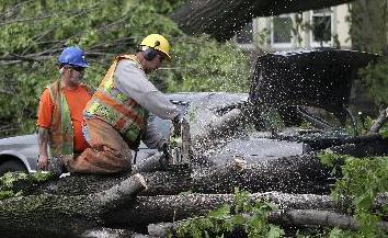
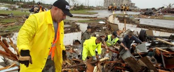
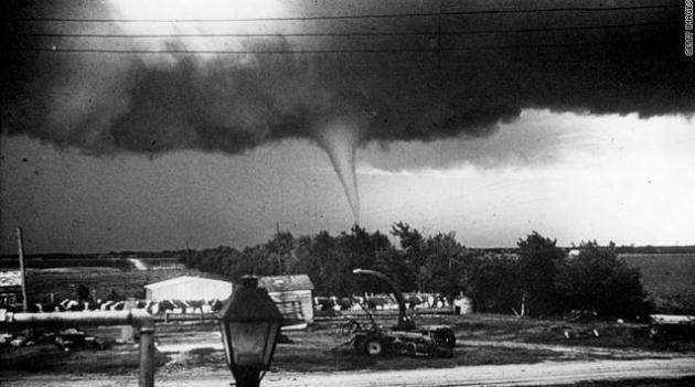
EF-5: Joplin tornado upgraded to a very rare EF-5 tornado, sustained winds estimated over 200 mph.
25,000 buildings in Joplin - half have been damaged or destroyed (CNN).
$3 billion: initial damage estimate from the Joplin tornado.
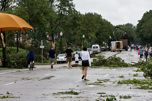
Update On Sunday's Tornado In Minneapolis. Here is the latest from the local Chanhassen office of the National Weather Service:
PUBLIC INFORMATION STATEMENT
NATIONAL WEATHER SERVICE TWIN CITIES/CHANHASSEN MN
505 PM CDT TUE MAY 24 2011

...STRONG EF-1 RATING ASSIGNED TO THE TORNADO THAT HIT NORTH
MINNEAPOLIS AND OTHER AREAS...

WINDS OF 100 TO 110 MPH WERE PRODUCED BY THE TORNADO THAT HIT NORTH
MINNEAPOLIS...ST. LOUIS PARK...GOLDEN VALLEY...FRIDLEY...MOUNDS VIEW
AND BLAINE. IT WAS ON THE GROUND FOR SIX AND ONE QUARTER MILES IN
HENNEPIN COUNTY...PLUS AN ADDITIONAL EIGHT MILES ACROSS ANOKA AND
RAMSEY COUNTIES AS THE TORNADO WENT THROUGH PARTS OF FRIDLEY...
MOUNDS VIEW...AND BLAINE.

THE TOTAL PATH LENGTH WAS 14 AND 1/4 MILES.  THE TORNADO WAS ABOUT
1/2 MILE WIDE AT ITS WIDEST POINT.  THE TIME OF TOUCHDOWN WAS
APPROXIMATELY 215 PM...BUT THIS WILL BE FINE TUNED IN THE DAYS TO
COME AS MORE EVIDENCE IS GATHERED.  ACCORDING TO VARIOUS SECURITY
CAMERAS...THE TORNADO MOVED INTO FRIDLEY AT 222 PM.

THE INITIAL TOUCHDOWN IN ST. LOUIS PARK WAS 3/4 OF A MILE
SOUTH-SOUTHWEST OF THE INTERSECTION OF INTERSTATE 394 AND HIGHWAY
100 WHERE TWO BUSINESSES SUSTAINED ROOF DAMAGE.  THE TORNADO MOVED
NORTHEAST...CROSSING HIGHWAY 100 WHERE IT HIT THE FIRST RESIDENCES
ALONG CEDAR LAKE ROAD. IT THEN ENTERED THE SOUTHEAST PORTION OF
GOLDEN VALLEY...CROSSED INTERSTATE 394 AND HEADED FOR THEODORE WIRTH
PARK.  DURING THIS TIME IT TOOK A BIT OF A NORTHWARD TURN AND BEGAN
MOVING TO THE NORTH-NORTHEAST.

THE TORNADO MOVED ACROSS WIRTH LAKE AND ENTERED THE CITY OF
MINNEAPOLIS BETWEEN GLENWOOD AVENUE AND 16TH AVENUE.  UP TO THIS
POINT...DAMAGE WAS EF-0 WITH THE VAST MAJORITY OF THE DAMAGE BEING
DOWNED TREES ATOP BUILDINGS AND VEHICLES.  AS THE TORNADO ENTERED
MINNEAPOLIS, IT STRENGTHENED TO EF-1...AND BEGAN DEMOLISHING
GARAGES...SHEDS...AND PARTIALLY REMOVING ROOFS. THERE WAS A HOUSE
HERE OR THERE THAT HAD THEIR ROOFS COMPLETELY REMOVED...BUT ADJACENT
HOUSES AND OTHER NEARBY STRUCTURES AND TREES DID NOT SUPPORT RAISING
THE LEVEL TO EF-2.

THE TORNADO HEADED FOR THE AREA AROUND PENN AVENUE AND BROADWAY
AVENUE...THEN LOWRY AVENUE AND LOGAN AVENUE...THEN TO 42ND AVENUE
AND LYNDALE AVENUE.  IT CROSSED THE MISSISSIPPI RIVER JUST NORTH OF
THE CAMDEN BRIDGE...AND BEGAN CAUSING DAMAGE IN ANOKA COUNTY.

IT MOVED ACROSS THE MINNEAPOLIS WATER INTAKE FACILITY. AT THE WATER
TREATMENT FACILITY...A FREE STANDING STORAGE GARAGE WAS COMPLETELY
DESTROYED...WITH NUMEROUS COTTONWOOD TREES ON THE GROUNDS UPROOTED
OR HAVING LARGE LIMBS SNAPPED OFF.

FROM THE WATER FACILITY...THE TORNADO TRACKED NORTHEAST TO A RAIL
YARD AND A LARGE INDUSTRIAL FACILITY...WHERE A LARGE METAL BUILDING
ON THE GROUNDS HAD PARTS OF TWO WALLS RIPPED OFF AND A LARGE SECTION
OF THE ROOF BLOWN OFF.

AT THE RAIL YARD...EIGHT TRAIN CARS WERE TIPPED OVER. THIS CAN BE
DONE BY WINDS LESS THAN 110 MPH. ON THE OTHER SIDE OF THE RAIL
YARD...MORE INDUSTRIAL FACILITIES AND WAREHOUSES SUSTAINED DAMAGE
ALONG MIAMI STREET...THE WORST BEING A WAREHOUSE THAT LOST PART OF
ITS ROOFING.

THE STRONGER EF-1 DAMAGE OCCURRED IN THE AREA BETWEEN PENN AND
BROADWAY AND THE CAMDEN BRIDGE.

THE TORNADO THEN MOVED ACROSS RESIDENTIAL SECTIONS OF FRIDLEY...
WHERE EXTENSIVE TREE DAMAGE WAS DONE NORTHEAST OF THE MIDDLE SCHOOL.
THE TORNADO THEN WEAKENED AS IT CONTINUED NORTHEAST ACROSS THE EAST
SIDE OF OF FRIDLEY TO SPRING LAKE...WHERE IT MOVED INTO THE
NORTHWEST SIDE OF MOUNDS VIEW. SPORADIC TREE DAMAGE OCCURRED DURING
THIS TIME FRAME.

THE LAST SIGNS OF DAMAGE WERE SEEN ON THE SOUTH SIDE OF THE
BLAINE-ANOKA COUNTY AIRPORT...WHERE A FEW HANGARS RECEIVED SOME
MINOR EXTERIOR DAMAGE.  THE TORNADO WAS ON THE GROUND FOR ABOUT 8
MILES FROM FRIDLEY TO BLAINE.
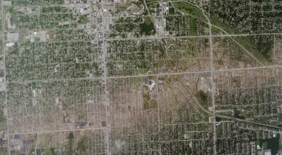
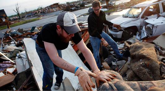
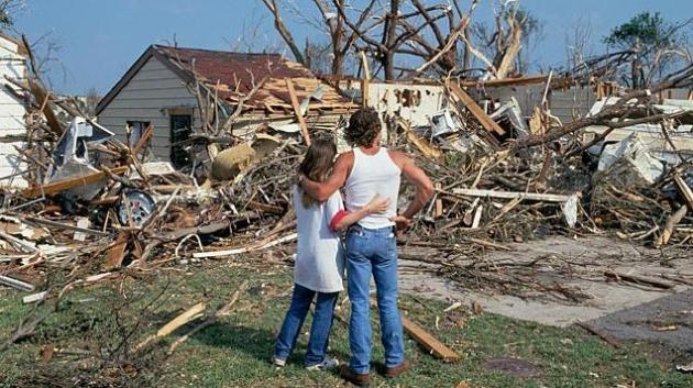
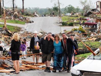
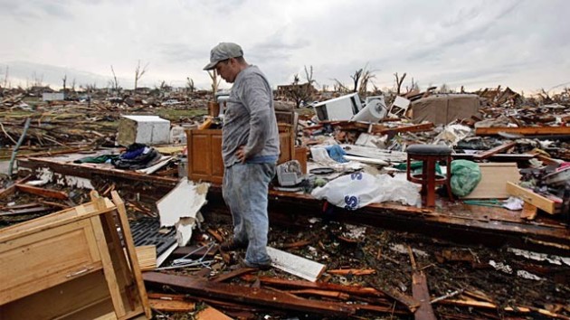
Joplin Damage Path. Aerial photographs show the extent of damage from Sunday's tornado, which ripped right through the heart of town. Full-resolution photo courtesy of Twitpic.
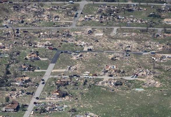
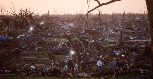
Multi-Vortex Tornado. NOAA meteorologists confirm that Sunday's tornado in Joplin was a multi-vortex tornado, as many as 3-5 tornadoes all rotating around a common center. Where those (small/fierce) mini-tornadoes struck damage was total. This accounts for the photo above, with pockets of nearly complete devastation next to homes still left partially standing. Photo courtesy of the news-leader.com.
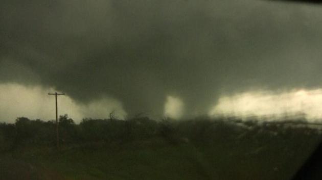
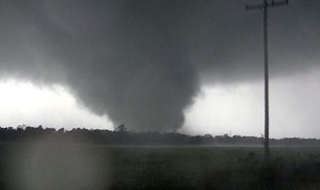
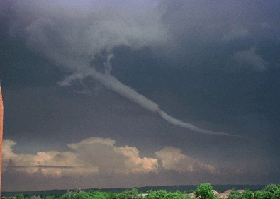
Weather Monster. The tornado that hit Joplin was similar to the multi-vortex tornado near Tushka, Oklahoma on April 14, 2011. Image courtesy of Wikipedia, which has more details on these rare (and often deadly) multi-vortex tornadoes: "A multiple-vortex tornado is a tornado that contains several vortices rotating around, inside of, and as part of the main vortex. These multiple vortices are somewhat similar to eyewall mesovortices found in intense tropical cyclones. The only times multiple vortices may be visible are when the tornado is first forming or when condensation and debris is balanced enough so that subvortices are apparent without being obscured. They are responsible for most (if not all) cases where narrow arcs of extreme destruction lie right next to weak damage within tornado paths. Suction vortices (or suction spots) are really substructures of many, perhaps all, tornadoes but are not always easily visible. These occur, usually, at the base of the tornado vortex where the tornado makes contact with the surface. Subvortices tend to form after vortex breakdown reaches the surface and are resultant from the ratio of cyclonically incoming and rising air motions. Multivortex structure is not unique to tornadoes, occurring in other circulations such as dust devils, but is a natural result of the physics of vortex dynamics.
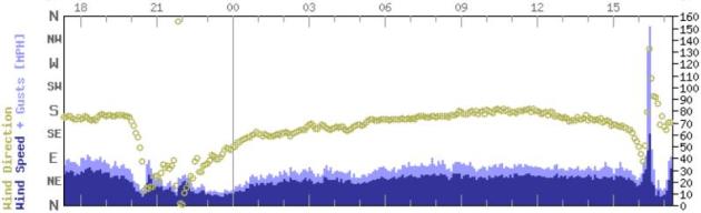
Signature Of A Tornado. I have never seen this before - an apparent tornado (or straight-line wind gust) hit El Reno, Oklahoma around 4:30 (the blue spike at the right end of the graph). Winds gusted to 150 mph, and (somehow) the anemometer continued to work after the storm passes. Remarkable. Thanks to the Oklahoma Mesonet - which you can access here.
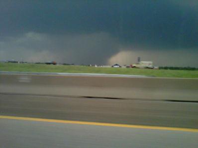
Fort Worth Wedge. That appears to be a 1/2 to 1 mile wide tornado in the Fort Worth area Tuesday evening, courtesy of Twitpic.

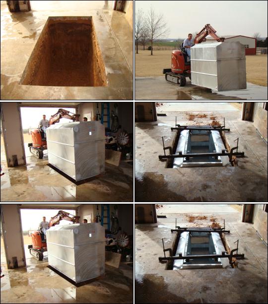
Tornado Shelter Options. This is just one of many tornado shelter designs I've come across - something called the "Flatsafe" shelter. It can be installed in a garage; it's ventilated - large enough to hold an entire family. it's designed to be able to withstand an EF-5 strength tornado. If you don't have a basement this could be a very good option.
Tornado-Proof Home? "Safe-Room" Is A Better Option For Purse And Family. ABC News has a very timely article about steps you can take to make your home more tornado-resistent. Concrete-reinforced homes are best able to withstand tornadic winds (which can bring down even steel structures). There is no way to build a cost-effective tornado-proof home, but we can make our homes more tornado-resistant: "People thinking about fortifying their homes against the wind's wrath after seeing the damage caused by this year's rash of powerful, deadly tornadoes should think twice, architects and engineers say. Though it is possible to build a tornado-proof home, experts say it is probably not worth the expense, which is likely to be at least 20 percent more in construction costs than a normal home, or worth the trouble. "You're talking about very well designed connections all the way down, very well engineered and very well tied together," said Stan Peterson, a member of the American Institute of Architecture disaster assistance task force. "You have to build to such high standards that when you try to make the entire house safe, that's not sensible," said Ernst Kiesling, a professor of civil engineering at Texas Tech University and executive director for the National Storm Shelter Association. "It greatly increases the cost [to build] the house."
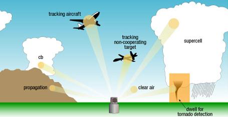
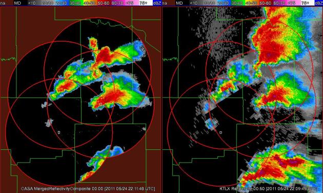
"Phased-Array" Doppler Radar. NSSL (National Severe Storms Lab) is making their (live) phased array experimental Doppler available online. Phased array is superior to conventional Doppler, which takes 4 minutes to scan all levels of a 3-D volume surrounding the radar site. There is no such thing as "live" NWS Doppler, the ground-level (.5 degree elevation) is sampled roughly once every 4 minutes. 99% of the time that's not an issue - but when a tornado is on the ground, moving at 50 mph, that 4 minute "gap" can be very problematic for meteorologists. More on phased array radar from NSSL: "Phased Array radar has a unique antenna that collects the same information as a conventional radar in about one-sixth the time. Researchers believe phased array could extend warning lead times from 10 minutes to 18-22 minutes. The radar's electronic beams can be directed independently at particular elements of a storm to give forecasters more accurate and complete data than the current NEXRAD radars. The new technology will also gather storm information not currently available, such as rapid changes in wind fields, to provide more thorough understanding of storm evolution. Researchers will be able to refine conceptual storm models and use that knowledge to evaluate and improve stormscale computer models. The phased array radar is expected to eventually replace the current network of WSR-88D radars. NSSL's National Weather Radar Testbed (NWRT) is the official facility where phased array technology will be tested and evaluated. PAR has the potential to provide revolutionary improvements in NWS tornado, severe storm, and flash flood warnings."
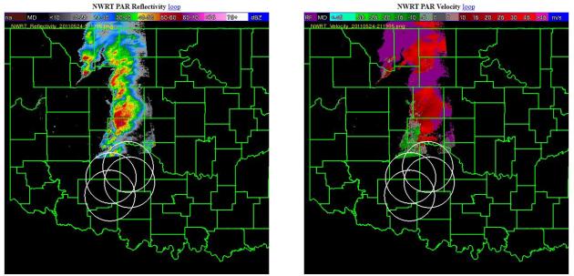
Swarms Of Hook Echoes. This is another example of phased array Doppler radar from NSSL in Norman, Oklahoma - images from Tuesday evening.
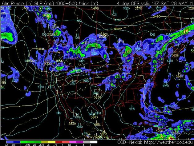
Noon Saturday. The GFS model is hinting at some morning and midday sun on Saturday, but an approaching trough of low pressure (unusually cold wrinkle of air aloft) may spark a few PM showers, even a T-shower. My hunch: the earlier in the day you plan your outdoor events, the better on Saturday.
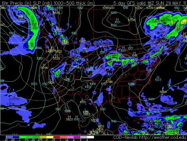
Noon Sunday. A stationary front draped across southern Minnesota may become a magnet for showers and a few strong T-storms Sunday. Expect more humidity, highs closer to 70, a few hours of (hard?) rain. A few isolated severe storms can't be ruled out from Sunday through Tuesday of next week as a vigorous warm frontal boundary remains just south of MSP.
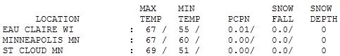

Gray Tuesday. The sun was out in St. Cloud, where the mercury SOARED to 69! Highs held in the mid 60s across most of the state, a meager 55 at Duluth, 44 at Grand Marais (with a raw wind blowing right off Lake Superior).
Paul's Conservation Minnesota Outlook for the Twin Cities and all of Minnesota:
TODAY: Unseasonably cool and windy. A few light showers in the metro, heavier rain over far southern MN. Winds: NE 10-20 (higher gusts). High: 62
WEDNESDAY NIGHT: Partial clearing. Low: 47
THURSDAY: Grab your camera. Risk of sunshine! High: 66
FRIDAY: Some cool sun early, clouds increase - PM hours with nighttime showers expected. Low: 46. High: 64
SATURDAY: Some sun, few PM showers, possible thunder. Low: 50. High: 65
SUNDAY: More humid, a few scattered showers and T-storms, some strong. Low: 50. High: 68
MONDAY: Muggy, few severe storms? Low: 56. High: 71
TUESDAY: Damp start, partial clearing. Low: 61. High: 79

Weather 2.0
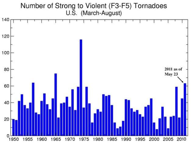
America's weather is rarely "average". We see more severe storms than any nation on Earth. Lately it seems like extreme weather has been on overdrive: epic floods, "exceptional" droughts, the worst tornado death toll in 60 years. Why? It may be a case of bad luck. There have been twice as many tornadoes than usual, to date. When you have that many tornadoes the law of averages will catch up to you. At some point large urban areas (like Joplin and Tuscaloosa) will get hit.
Dr. Jeff Masters from the Weather Underground believes "there is more energy in the system." 2010 tied for the warmest year on record - last winter was the coldest in 25 years for the USA, while Canada saw the warmest, driest winter on record. A warmer atmosphere means more potential energy for storms of all sizes, he explains. "The climate may be transitioning to a new state - a new normal." Time will tell if all these super-sized storms is just a fluke, or harbingers of a new, stormier (deadlier) pattern.
Rain is likely today (nothing severe) - temperatures on the cool side. We get a sunny break Thursday before more showers Friday night. T-storms are possible again Sunday, maybe a severe outbreak by Monday.
- When discussing extreme weather and climate, tornadoes should not be conflated with the other extreme weather events for which the connection is considerably more straightforward and better documented, including deluges, droughts, and heat waves.
- Just because the tornado-warming link is more tenuous doesn’t mean that the subject of global warming should be avoided entirely when talking about tornadoes.
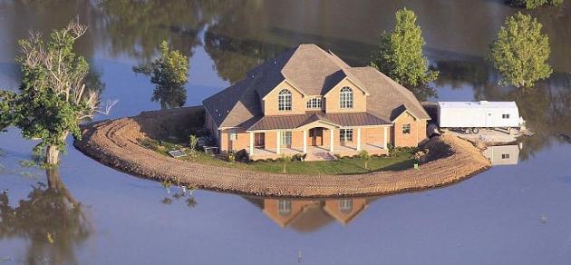
Joplin Tornado Damage Could Total $3 Billion. CNN Money and KCCI-TV in Des Moines have the latest information: "The tornado that devastated Joplin, Mo., killing at least 117 people, may have caused up to $3 billion in insured losses, according to an estimate from a catastrophe risk modeling firm released Tuesday.Eqecat Inc. estimated that the tornado that flattened the city of about 50,000 people on Sunday caused from $1 billion to $3 billion worth of damage to insured buildings - including homes, businesses and factories - and automobiles, according to Jose Miranda, director of client advocacy.Miranda said the firm based its estimate on reports that up to 2,500 buildings in the city were destroyed and up to 10,000 were damaged, in a city with an estimated 25,000 buildings.He said the true cost of the damage is unclear, since Eqecat does not have data for uninsured losses.The Joplin tornado is the single deadliest tornado in U.S. history, in what has been a particularly catastrophic year. So far this year, tornadoes have killed 482 people in the United States.This year was relatively calm, as far as natural disasters are concerned, until April, when a series of three severe storms ripped through the Southern states, causing up to $5 billion worth of damage. The most serious storm featured 178 tornadoes and killed at least 300 people, many of them in Alabama."
Property/Casualty Insurers Facing Record Losses From Weather. Here is the Reuters story at claimsjournal.com: "Devastating tornadoes, floods, earthquakes overseas and a busier-than-usual hurricane season have U.S. insurance companies bracing for record losses in 2011. Insurers could suffer as much as $10 billion from weather-related losses in the United States in 2011, which is up from the average of $2 billion to $4 billion, according to EQECAT Inc, which provides disaster and risk models to insurance companies. On top of the potential U.S. losses, insurers are also reeling from disasters overseas, including large earthquakes across the Pacific Rim. And as if that was not enough, analysts now expect an above-average Atlantic hurricane season. “This is not a black swan year that is an absolute worst case, but it is significant and it is close to that,” said Jose Miranda, director of client advocacy at EQECAT Inc, which provides disaster and risk models to insurance companies. Globally — including the major earthquakes in New Zealand and Japan — U.S. and overseas insurers could post up to $55 billion in losses, EQECAT projects. Some insurers have already posted large losses due to the Japan and New Zealand quakes. Berkshire Hathaway Inc. lost $1.07 billion from the Japan earthquake and $412 million from the quake in New Zealand."

Thanks for posting! keep it up! Water damage minneapolis
ReplyDeleteNice blog..Thanks for sahring it..
ReplyDeletemoving & storage services georgia