TODAY: Blue sky, refreshing breeze. Winds: NE 10-15. High: 64
MONDAY NIGHT: Clear and cool (probably frost-free). Low: 42
TUESDAY: Sunny and beautiful with light winds, low humidity. High: 67
WEDNESDAY: Lukewarm sun, still dry. Low: 45. High: near 70
THURSDAY: Less sun, isolated PM shower. Low: 52. High: 73
FRIDAY: Humid, PM T-storms possible. Low: 58. High: 74
SATURDAY: Showers, T-storms. Some heavy. Low: 59. High: 75
SUNDAY: Sticky, pop-up PM T-storms. Low: 57. High: 78

Late Frost. Some daffodils and tulips may freeze their buds off this morning. Odd, with the summer solstice roughly 5 weeks away. On average the Twin Cities International Airport sees its last 32 F. reading on April 29, but outside the metro area May frosts are not unusual. The last 32 F. reading in Maple Plain is May 6, on average - May 9 up at Cambridge. Click here to see the average last 32 for your town, courtesy of the MN State Climatology Office. This morning, under clear skies, light winds and a sprawling Canadian high pressure bubble frost is possible in the outlying suburbs, outside the 494/694 freeway. The "urban heat island" (buildings, homes, concrete and asphalt re-radiating the sun's energy during the nighttime hours) keeps the downtowns and close-in suburbs as much as 5-15 degrees warmer than outlying suburbs. For the record, the growing season in downtown Minneapolis is nearly 2 weeks longer than it is in Medina, Lakeville or Stillwater. Great news for farmers in Minneapolis.
URGENT - WEATHER MESSAGE
NATIONAL WEATHER SERVICE TWIN CITIES/CHANHASSEN MN
228 PM CDT SUN MAY 15 2011
FROST POTENTIAL (EARLY MONDAY)...
A FROST ADVISORY HAS BEEN ISSUED FOR PORTIONS OF CENTRAL AND SOUTHERN MINNESOTA...AS WELL AS PORTIONS OF WEST CENTRAL WISCONSIN FROM 3 AM TO 7 AM MONDAY MORNING. WINDS WILL BEGIN TO DECREASE THIS EVENING...AND WITH CLEAR SKIES...TEMPERATURES WILL BEGIN TO DROP INTO THE 30S AFTER MIDNIGHT. SOME OF THE MORE SHELTERED AREAS IN MINNESOTA AND WISCONSIN MAY DROP TO NEAR OR BELOW FREEZING BEFORE SUNRISE.
ALTHOUGH A WIDESPREAD FROST IS NOT LIKELY IN THE INNER CITY OF MINNEAPOLIS AND ST PAUL...MAINLY DUE TO THE HEAT ISLAND EFFECT...PEOPLE SHOULD BE ON THE CAUTION SIDE AND COVER UP ANY VEGETATION.
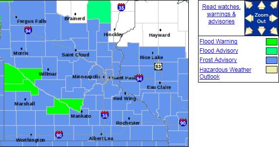
Frost Advisory. The local National Weather Service office has issued a frost advisory for all of central and southern Minnesota through the early morning hours. This is why you normally wait until Labor Day to plant those tender annuals. If you missed out on frost this morning you're probably OK from here on out - a definite warming trend kicks in this week. With any luck that's the last frost risk until sometime in September. In theory.
* Last year the last 32 F. low temperature in the Twin Cities was May 9.
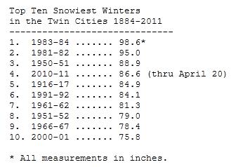
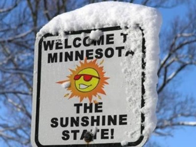
Winter Is Over - I think. If we get any more (accumulating) snow I will personally wash and wax Belinda Jensen's vehicle (SUV?) During a typical May MSP picks up a "trace" of snow flurries. We already had our May flurries (on the 2nd), and I suspect snow season is finally behind us now. The jet stream is lifting north - we're FINALLY seeing signs of a significant shift in the pattern. Warmer weather is imminent - 70s are likely by the end of this week. More details from the Minnesota State Climate Office: "The Winter of 2010-2011 is the fourth snowiest so far in the Twin Cities. Through (May 16) the Twin Cities International Airport has measured 86.6 inches of snow for the 2010-2011 winter season. This is enough to be in 4th place for the snowiest winter over the past 127 years. The snowiest season on record is the winter of 1983-84 with 98.6 inches."
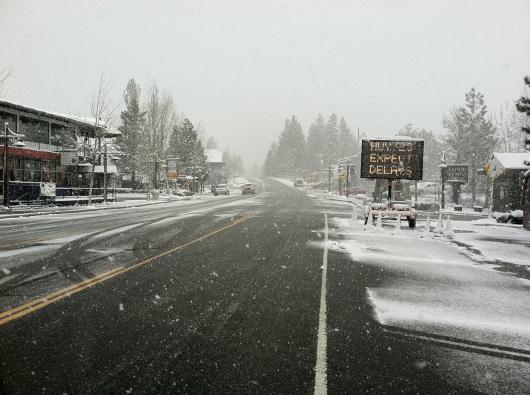
Are You SURE The Summer Solstice Is 5 Weeks Away? This was the scene in the Lake Tahoe, California area on Sunday, as a freak late-season snowstorm sparked heavy snow. Photo courtesy of Twitpic.
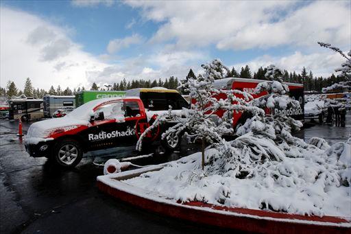
Snowstorm Wipes Out Tour Of California Stage. A major bike race cancelled due to....snow? What month is this again? Details from the Sacramento Bee: "TRUCKEE, CA: Harried officials of Amgen Tour of Cahoped for improved weather to kick off America's biggest cycling race Monday after scuttling Stage 1 because of a severe spring snowstorm that slammed the High Sierra. Race officials canceled a 118.7-mile stage beginning in South Lake Tahoe 15 minutes before the start Sunday because of deteriorating conditions. For the first time in anyone's memory a day of competitive cycling in the United States was canceled-a particularly ignominious moment for the 6-year-old tour that was moved from February to May in 2010 to take advantage of the state's usually sunny spring days. Officials made the decision to protect the riders from any mishaps. They said six race marshals on motorcycles crashed along the course Sunday, though none suffered injury. "There was definitely a concern with the safety of the course and the really fast descent," veteran U.S.pro cyclist George Hincapie said in a statement. "If it's icy, you don't have control of your bike."
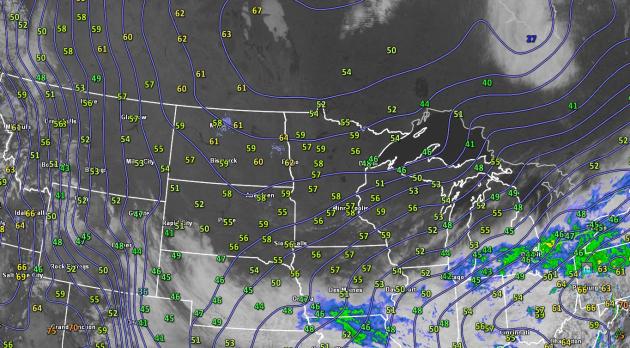
Steady Improvement. A sprawling bubble of high pressure centered over the prairies of central Canada will dominate Minnesota's weather pattern through midweek, winds gradually easing as the center of this fair weather "high" settles directly overhead Tuesday and Wednesday - arguably two of the nicest days of spring.
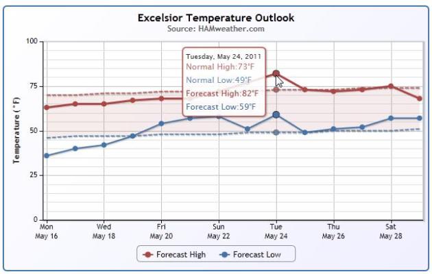
Nice To Be "Average" Again. The red-dashed line shows average highs, the blue-dashed line displays average low temperatures. As you can see our temperatures will be trending a few degrees above average - maybe some 80s by Tuesday of next week? Graphic courtesy of NOAA and Ham Weather, a division of WeatherNation. Plug your zip code in here to see a temperature outlook for your town.
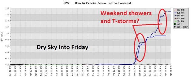
Breaking News: Best Week of Spring? A stalled bubble of high pressure should keep us dry into Thursday morning, possibly Friday. But the next southern storm rotates bands of showers and T-storms into Minnesota by the weekend. At least it'll be a lukewarm (spotty) rain, with highs in the 70s. You know, more like "spring"?
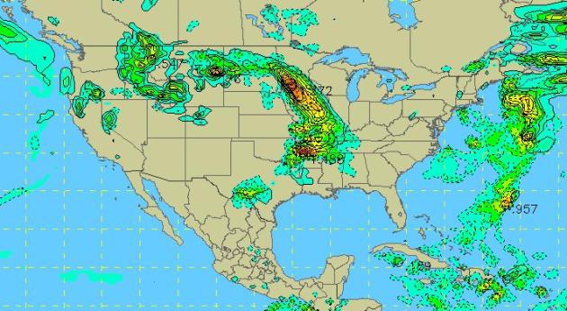
Looks Like A Saturday. What is it about Saturdays that attract puddles to Minnesota? April showers bring...May showers. The GFS outlook valid 7 am Saturday morning hints at a band of heavy showers and T-storms entering southwestern Minnesota. I don't expect a steady rain (like last Saturday), but a few hours of heavy showers and T-storms are possible Saturday, again Sunday, as highs reach into the 70s.
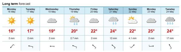
Another Perspective. The European model is hinting that Saturday may be the wetter day of the weekend, with 10 mm. of rain (about .4"). Highs should be in the mid 70s. That's right, next weekend may actually feel like spring.
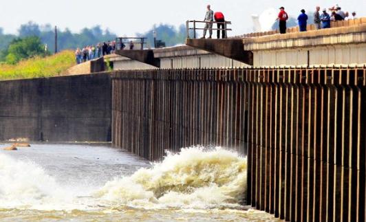
Facing The Prospect Of Losing A Home. Thousands of homes in Louisiana are threatened by the rapidly rising waters from the Mississippi. In order to save New Orleans the Army Corp of Engineers had to make an impossibly complex decision, opening up spillways upstream that should ultimately lower the risk of catastrophic flooding in New Orleans, but shift the flooding woes westward, literally opening up a new path for the excess Mississippi River water to reach the Gulf of Mexico. The New York Times has the story: "BUTTE LA ROSE, La. — You do not really want to ask a Cajun why he lives in a swamp, especially when he is packing everything he owns because the very swamp he loves is about to swallow up his house. The Army Corps of Engineers opened a portion of the Morganza Spillway on Saturday afternoon to relieve pressure on the levees from a bulging Mississippi River, and millions of cubic feet of water began rushing into the Atchafalaya Basin. The corps expects to open more of the spillway in the coming days, allowing the water to rise steadily throughout the basin. In a day, maybe two, it will start to engulf this little river community in Cajun country."
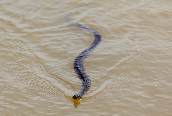
Officials: Flooding To Force Louisiana Wildlife To Higher Ground. Can you imagine what's actually in that swirling, muddy water? Snakes (some poisonous), alligators - all heading to what little high ground is left, as reported by USA Today: "MONROE, La. -- Southwestern Louisiana wildlife, including a segment of the state's black bear population, will begin seeking dry ground as the Atchafalaya Basin slowly floods from Saturday's opening of the Morganza Spillway, the state's top wildlife officer said. "A tremendous volume of water is going to be flushed into the basin," Louisiana Department of Wildlife and Fisheries Secretary Robert Barham said. "But we have a commitment from the (Army Corps of Engineers) that it will be done in a gradual manner. "This is a critical time for the black bears. They're coming out of their dens with cubs. You can't send a tsunami into the Atchafalaya Basin and expect those cubs to survive." Barham said northeastern Louisiana, especially the Tensas National Wildlife Refuge, is home to the state's largest population of black bears, but he estimated there is "a concentration of 200 or so bears from the Morganza Spillway to (Interstate 10)." "Northeastern Louisiana isn't so critical because any bears living on the unprotected side of the levee travel over it and know where to go; they're used to this," he said. "That's not the case in the Atchafalaya Basin. This hasn't happened in almost 40 years. These bears don't know where to go."
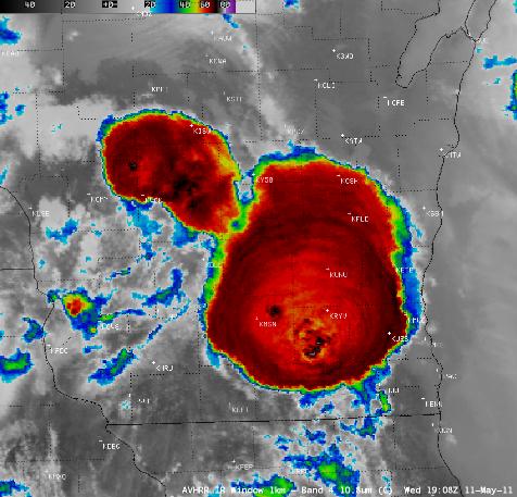
Convective Outflow Boundary And Softball-Size Hail In Southern Wisconsin. Last week's severe weather outbreak produced softball size hail (over 4" in diameter). Meteorologists are discovering the importance of "gravity waves" as precursors to (especially) severe weather. The University of Wisconsin CIMSS blog has more details: "AWIPS images of 1-km resolution GOES-13 0.63 µm visible channel data (above; click image to play animation) showed a convective outflow boundary (originating from strong thunderstorms earlier in the day over northeastern Wisconsin) propagating southward across the eastern portion of the state on 11 May 2011. The leading edge of the outflow boundary moved farther to the south over the nearshore waters of Lake Michigan, where surface friction was less than that over land. Later in the day, clusters of severe thunderstorms were seen to develop over southcentral and southeastern Wisconsin, along an advancing warm frontal boundary. A 1-km resolution POES AVHRR 10.8 µm “IR window” image at 19:08 UTC (2:08 pm local time) revealed a number of overshooting tops, which exhibited IR brightness temperature values as cold as -70 to -78º C (black to white color enhancement). Overlaid are the numerous SPC reports of hail that had occurred up through 22:06 UTC — hail was as large as 1.75 inches in diameter in Dane County (where observation station Madison KMSN is located), and as large as 4.25 inches (softball-size) just to the east in Jefferson county (where observation station Watertown KRYV is located). A subtle signature of outward-propagating concentric gravity waves could also seen on the IR image of this hail-producing storm, which was especially evident over the northern portion of the cold cloud shield."
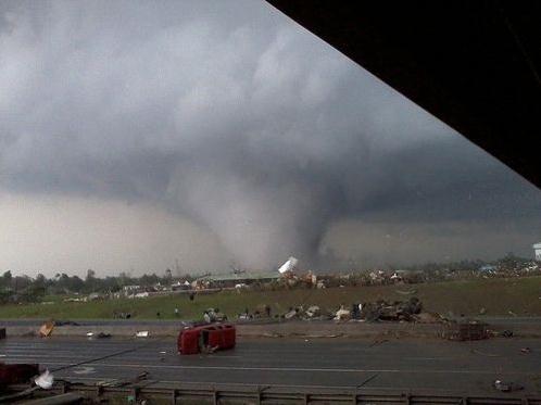
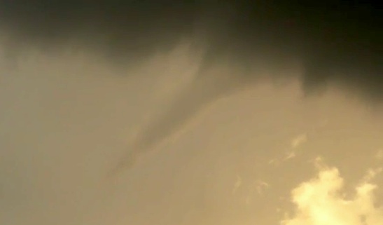
Terrifying Sight. For nearly 15 years I've been telling people NOT to seek shelter under concrete bridge overpasses, and yet the Tuscaloosa tornado survivor who managed to snap this photo of the retreating "wedge" tornado did just that, and lived to tell about it. If I was on a local freeway, and the only option was 1). ditch, or 2). concrete overpass I admit that I too would be tempted to crawl up under the bridge (inside the girders, if possible, to protect myself from flying debris). This photo, more than any other picture I've seen, sums up the power of the storm, and the resulting horror of the aftermath. Photo courtesy of Ow.ly.
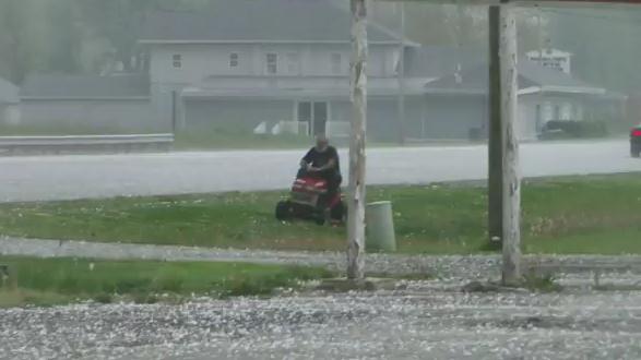
What Not To Do During A Hailstorm. This guy was determined to get the grass cut. "A little hail? No problem." But when the hail is ping-pong size, 1.5" in diameter, (and you're not wearing a helmet) you might want to reconsider your options. This guy deserves a raise - and a big dash of common sense would be nice, too. YouTuve video is here (not for broadcast).
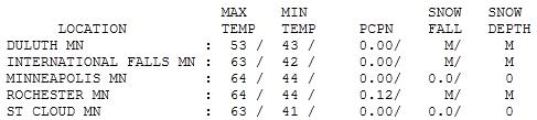

On The Right Track. In spite of a cool breeze it felt pretty good out there Sunday. A perfect blue sky, low humidity, unlimited visibility, no bugs (yet). It almost felt like late September or early October. Progress. Highs ranged from 47 at Grand Marais (raw breeze off Lake Superior) to 63 in St. Cloud, 64 in the Twin Cities - 6 degrees cooler than average.
Turning The Corner?
"Everything in moderation," my dear father is fond of saying. My question: what happened to weather moderation? The last 5 months has been the meteorological equivalent of drinking from a fire hose!
The snowiest winter since 1984, 86.6" snow, 4th snowiest since 1884. Record floods. Late ice-out. Flurries in early May. Frost & coats in mid May. 88 last Tuesday with a tornado in St. Micheal (photo above). Record high dew points for the first half of May. As soon as I find time I'm going to schedule a nervous breakdown.
Now, finally (!) the jet stream, the high-speed river of air snaking around the Northern Hemisphere, is showing grudging signs of lifting north. That will mean a string of 70s late in the week, T-storms, with a fairly stormy weather pattern into late May.
Why the old-fashioned winter & stunted spring? Proving cause and effect with the atmosphere is tenuous, but La Nina, the cooling of Pacific Ocean water, is probably a key factor. My strong hunch: a stormier, cooler pattern will linger into much of the summer. We won't see 113 tornadoes, like 2010, but I sense another above-average season for severe storms. Mild sun lingers into Thursday AM; the next southern storm pushes showers and T-storms our way by late week.
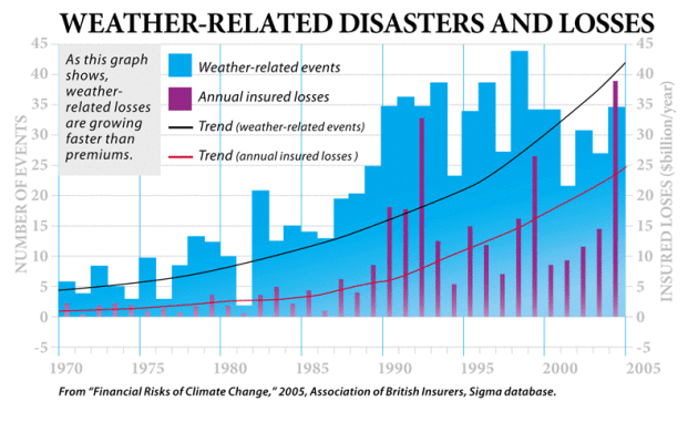
Will Climate-Related Disasters Convince Americans Global Warming is Real? Treehugger.com poses the question. Sadly, I believe it will take a series of major weather disasters, more floods, extreme hurricanes, pervasive drought and deadly heat - to convince a significant percentage of Americans that climate change is, in fact, making our weather more extreme. That's just my personal opinion, I hope I'm wrong on this one: "What if a hurricane even nastier than Katrina -- made stronger by the warmer climate -- were to barrel through Florida and leave a trail of destruction in its path? What if the American Southwest were to transform into an arid, drought-laden scorching-hot Dust Bowl and give rise to major water crises and suffering for millions? What if floods of biblical proportions were to devastate a major metropolis? Well, the way some in the green community see it, such disasters would be truly terrible -- truly, truly terrible, they stress -- but they might be necessary to wake the public up to the threats posed by climate change. As you're likely aware, there's a growing trend toward skepticism in America (I just explored this at length over at Slate). Does this idea -- that it will take a massive, climate change-related disaster to get Americans to believe in global warming -- have any merit? Grist's David Roberts doesn't think so. Yesterday, he focused his column on the subject: "Americans won't wake up and get serious about climate change until there's a disaster." I've been hearing people say that for years, but more and more lately ... I think that's a dangerous temptation that should be strenuously avoided. First and foremost, disasters suck: They impose a great deal of suffering on innocent people. It is never a good thing when that happens. But even if the moral reason is set aside, there are still two practical reasons to doubt that disasters will prompt the kind of change climate hawks would want.
a) Our economy is too big to be seriously impacted by such a disaster; they simply wouldn't be costly enough to force legislators to take action. And,
b) There's no reason to think that the public and elected officials would react rationally to such an event -- "People don't tend to respond to trauma with good will and foresight. They become more susceptible to demagoguery ... not less. I'm not sure a battered and fearful American public is one we can expect to embrace progressive change."
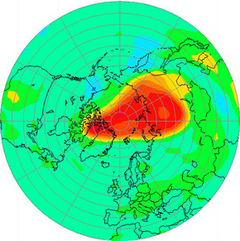
The Other Threat Above. The Business Standard and sify.com have a story focusing on another environmental threat that is causing concern in scientific circles: ozone depletion in the stratosphere, the "ozone hole" that created worldwide panic in the 1970s. Banning aerosols with CFC's helped the situation to some degree, but there is still a potentially dangerous lack of stratospheric ozone over the poles during the winter months. Ozone acts as a shield against harmful UV radiation from the sun - manmade chemicals can eventually drift into the stratosphere, and under specific conditions (extremely cold temperatures and a stagnant "polar vortex") can break down into chlorine and water - thinning this protective ozone shield: "Even as the world grapples with the threat of global warming and climate change, attention must be paid equally to another atmospheric phenomenon — the damage to the Earth’s ozone layer that shields Earth-dwellers from the Sun’s harmful ultraviolet radiation. Depletion of the ozone layer has reached an unprecedented level over the Arctic this spring, reports the World Meteorological Organisation (WMO). Ominously, it also warns that if the ozone-depleted area moves away from the pole and towards lower latitudes, one can expect ultraviolet radiation levels to rise abnormally. These rays can cause dreaded maladies like skin cancer, cataracts and, worse still, degradation of the human immune system. Its ill-effects may be felt in some crops and forms of marine life as well. Though the occurrence of the ozone hole over Antarctica is an annually recurring phenomenon due to a drop in temperature in the stratosphere, the second topmost layer of the atmosphere, what is worrisome is that the ozone column loss this year had reached 40 per cent until March. This is a good 10 per cent higher than the maximum depletion ever recorded before in the entire winter season. The Antarctic winter is not yet over."
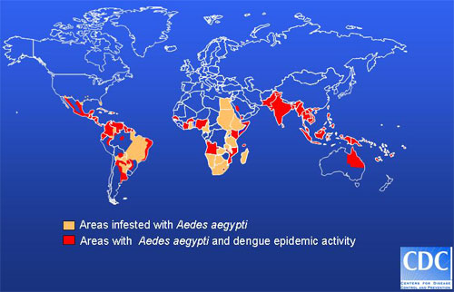
Climate Change Bringing Hunger, Infection, Illness. Reuters Health as the story: "Climate change threatens far more than our environment. It's already led to the spread of infectious diseases and respiratory ailments across the globe and contributed to thousands of deaths through heat waves and other extreme weather events. It's even fueled recent revolts in the Middle East and North Africa. That's according to Dan Ferber and Dr. Paul Epstein, the authors of a new book, Changing Planet, Changing Health: How the Climate Crisis Threatens Our Health and What We Can Do about It (University of California Press, April 2011). The health of all humans is directly tied to how we, as communities, nations, and a global population, respond to the growing climate threat, says Ferber, a science journalist and Epstein, Associate Director of the Center for Health and the Global Environment at Harvard Medical School.Ferber and Epstein spoke with Reuters Health Thursday about how malaria, Lyme disease, and cholera, as well as food shortages and malnutrition, are all becoming increased risks with steadily rising temperatures. (See the live blog from the discussion here: bit.ly/lJnshE) "
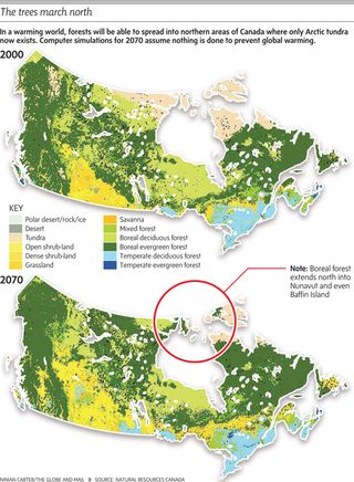
As Treeline Shifts North, Wildlife Will Change. The Vancouver Sun documents some of the transformations taking place just to our north: "The Arctic treeline -the point where boreal forest gives way to tundra as one heads north -may shift 500 km further north by 2100 as climate change greens the barren tundra and causes sweeping change to wildlife, a leading expert said. A quickening melt of snow, ice and permafrost will enable more southerly species such as pine trees or animals such as foxes to move north, but eliminate habitat for more northerly species. "Changes seem to be happening even more rapidly than we had anticipated just 10 years ago," Aevar Petersen, chair of the Conservation of Arctic Flora and Fauna (CAFF), said. "Scientists estimate the treeline could move 500 km north by 2100 from now," he said, based on CAFF projections. If that happened, as much as half the Arctic tundra from Siberia to Canada could vanish. In some places, southerly evergreen shrubs were taking over from grasses, mosses and lichens typical of tundra. "The tree line is moving north quite rapidly," he said. Warming in the Arctic is happening about twice as fast as in the rest of the world. As reflective snow and ice recede, they expose soil or water which are a darker colour and so soak up more of the sun's heat."
No comments:
Post a Comment