Drier weather likely Thursday into Friday morning.
Slight Severe Storm risk late Friday.
Saturday appears to be the sunnier, drier day of the weekend, highs: upper 70s to low 80s.
Sunday: more numerous (heavy) thunderstorms in the area, 70s north, mid to upper 80s possible south.
Major storm/severe storm outbreak by Monday of next week? Details below.

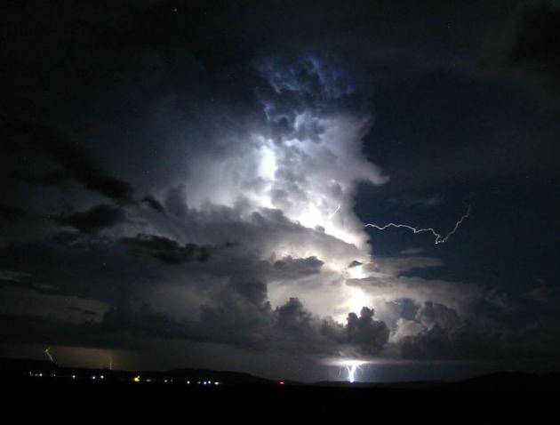
"A Noisy Pattern". A stalled frontal boundary coupled with a nearly stationary storm in the upper atmosphere will keep showers and T-storms in the forecast through the weekend. No continuous rains, but this is going to be a stormy pattern for Minnesota straight through Tuesday of next week.
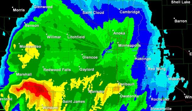
Tuesday PM Rainfall. NWS Doppler estimates show .50 to 1" rain in the immediate metro area, over 1.5" soaked most counties south of the Minnesota River, with 3"+ amounts between Windom and Marshall.
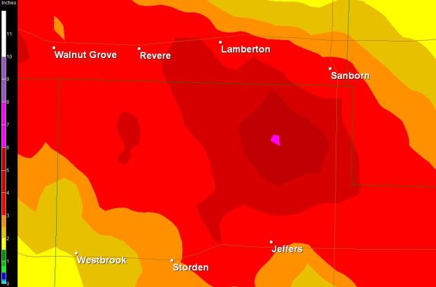
Soggy Bullseye. Doppler radar estimates show some 4-5" rainfall amounts between Jeffers and Lamberton, as much as 6" possible - that's why Flash Flood Warnings were issued for far southwestern Minnesota.
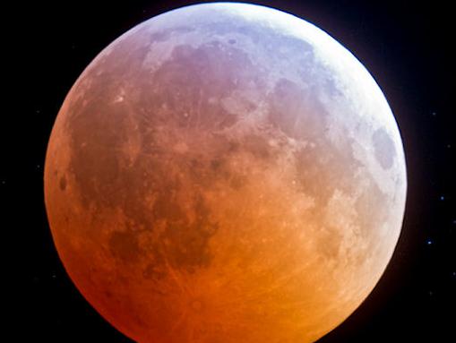
"Volcanic Lunar Eclipse". This may be visible tonight across Minnesota - with scattered T-storms in the area no guarantees (there never are). More from spaceweather.com: "On Wednesday night, June 15th, there's going to be a total lunar eclipse visible from every continent except North America. The Moon will spend 100 minutes fully engulfed in Earth's shadow, making this the longest lunar eclipse in nearly 11 years. Maximum coverage occurs on Wednesday night at 20:12 UT. [details] [animated map] [webcasts: #1, #2] Exhaust from the erupting volcano in Chile could affect the appearance of the eclipse."

Back To The 50s. 11,000 amazing vehicles, nearly 100,000 car-loving fans at the Minnesota State Fairgrounds this weekend. The forecast calls for scattered T-storms over the weekend - probably no steady, all-day washouts. Highs should top 80 Saturday, possibly climbing well into the 80s on Sunday (with muggy humidity levels). More details from the Minnesota Street Rod Association here.
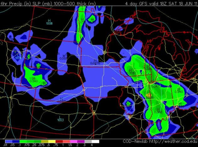
Saturday: Brighter/Drier Day? It's early, a lot can happen between now and the weekend. The GFS model is hinting at intervals of sun Saturday, especially over the southeastern half of Minnesota and northern Wisconsin - best chance of PM storms over the Red River Valley. Highs should be in the upper 70s to near 80. (GFS model map above valid at 1 pm Saturday, showing predicted rainfall for the previous 6 hours).
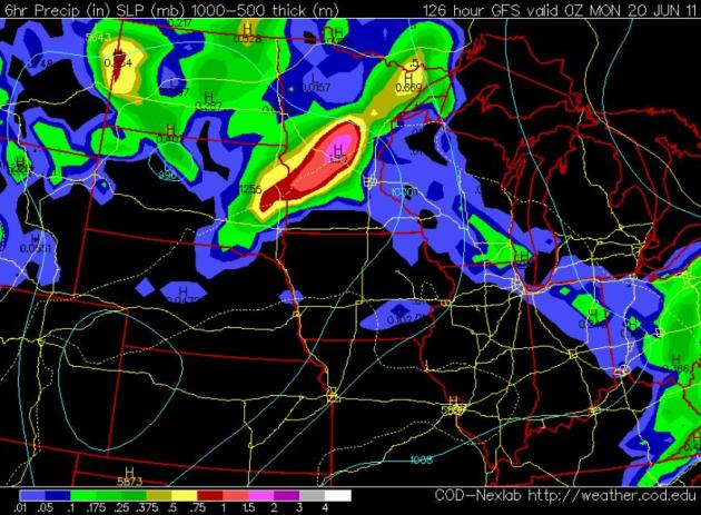
Sunday: Potentially Stormier. The latest GFS run prints out more widespread (and heavy) T-storms across Minnesota. The map above is valid at 7pm, showing predicted rainfall Sunday afternoon. The bright red/purple areas are show areas of Minnesota where 1"+ of rain is expected during that 6 hour period.
Potential For a Major Storm - Severe Weather Outbreak Early Next Week? Most precipitation in June is "convective", showers and thunderstorms. It's rare to get a broad area of heavy/steady rain a few days before the summer solstice. Then again, this has been anything but a typical spring, nationwide. The GFS model shows a full latitude trough of low pressure, with a "closed-low" circulation over the Red River Valley by next Monday. A major storm may develop over the central Plains and track northeast toward Minnesota or Wisconsin - producing heavy rain, even a potential for a widespread severe storm outbreak close to home early next week. Way too early for specifics - my point: storms should be widely scattered and fairly infrequent through Saturday, but more widespread/heavy/severe storms can't be ruled out from late Sunday into a portion of Tuesday of next week.
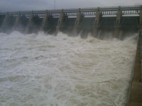
An Onslaught Of Water. Photo of Gavins Point Dam at 150,000 cubic feet per second from @mattbreenKTIV http://yfrog.com/hsl70bjj #MORiver. Pic courtesy of Terry Branstad and yfrog.
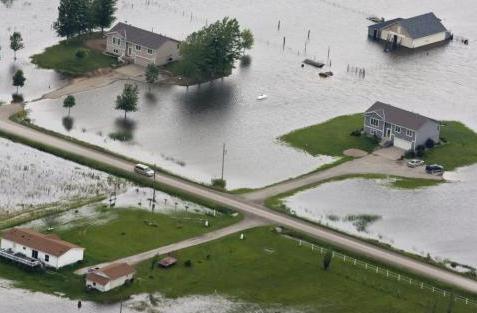
Iowa Town To "Make Our Stand" Against Flooding. A 20 mile stretch of Interstate 29 is shut down because of the swollen Missouri River. The levee upstream of Hamburg, Iowa was breached Monday; the Army Corp of Engineers is frantically trying to bolster the levee by adding 2-3 feet of soil - in a worst case scenario (if the reinforced levee doesn't hold) the town could be under as much as 10 feet of water. USA Today has the latest details: "The southwestern Iowa town of Hamburg is bracing for flooding after a Missouri River levee collapsed Monday, threatening the farming community of about 1,200. Army Corps of Engineers contractors are racing to add earth to a secondary levee system ringing Hamburg after the main levee, partially breached last week, punched open a 300-foot hole by Monday evening. "We're just making preparations to make our stand. We're still dry and hoping it'll stay that way," Hamburg Fire Chief Dan Sturm said. The National Weather Service issued a flash flood warning for the area. About 600 residents were evacuated last week, when the levee, 5½ miles west of town, began leaking. Col. Bob Ruch, head of the corps' Omaha district, said crews are adding several feet of earth to the secondary levees to protect Hamburg. "For right now, we believe we'll be able to get that elevation raised in the time available as that water flows across in the next 48 hours," Ruch said.

The state planned to close a 23-mile stretch of Interstate 29 east of town."
Too much moisture over the Northern Plains, while a devastating drought grips much of the southern USA:
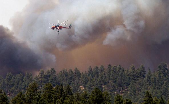
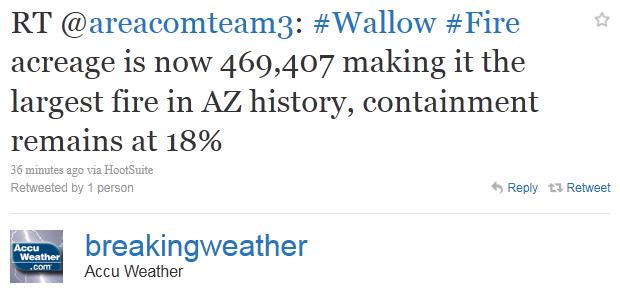
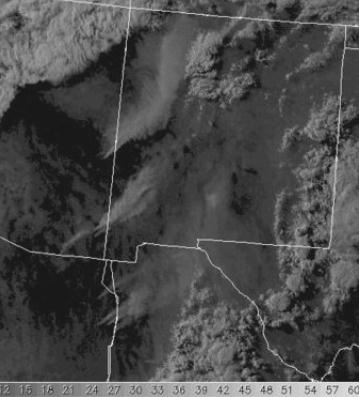
"Monument Fire." The "Wallow Blaze" has already scorched an area roughly the size of metro New York City and Los Angeles COMBINED. New blazes are igniting across Arizona, and now, New Mexico, fanned by 3% relative humidity levels and winds gusting over 40 mph. An update from "MadWeather": "A new wildfire started up in Coronado National Monument yesterday afternoon. It grew quickly and was threatening folks who live along the foothills south of Sierra Vista - including Art Douglas and his new home in Ash Canyon. Art reports that he has valuables packed in two vehicles and is ready to evacuate if he has to. Top image shows visible satellite image from yesterday afternoon around 6 pm. The smoke plumes and fires in Arizona are: Wallow fire along middle portions of Arziona/New Mexico border; the Horseshoe 2 fire along the southeast Arizona border; and now the Monument fire to the southwest of the Horseshoe 2 fire, along the Arizona/Mexico border. Note also that there are several large fires burning in northeastern Sonora, south of the border. Bottom photo shows the Monument fire last evening burning south of Sierra Vista."
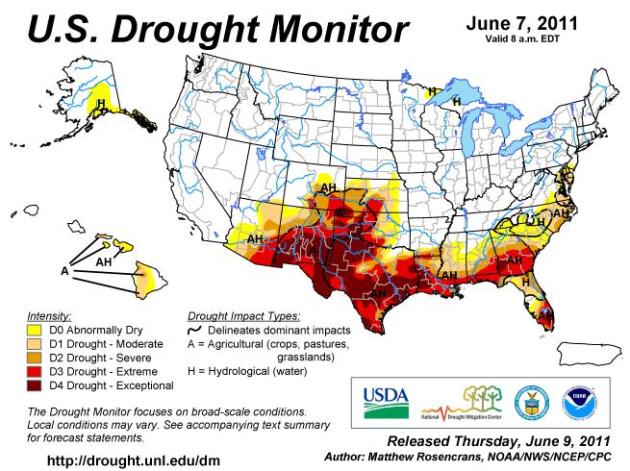
"Exceptional Drought". According to NOAA's Drought Monitor 8 states from New Mexico to Florida are experiencing an exceptional drought - the most severe drought possible. Portions of Texas are running 20"+ below normal in the rainfall department since last autumn.

Summer Skiing Anyone? Snowbird Resort, in the Wasatch range outside Salt Lake City, is still open on weekends through the 4th of July. Many slopes still have 50-100" or more of snow on the ground. This is only the 3rd time in Snowbird history that the resort is staying open through Independence Day.
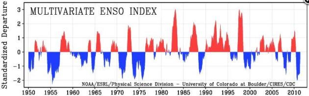
ENSO Update. A majority of climatologists and oceanographers believe that La Nina is weakening into an "ENSO-neutral" state, meaning ocean water temperatures close to average. But that opinion is not unanimous - a few experts believe that this may just be a temporary state; that La Nina may return later this year and linger into 2012. It may be too early to tell. Here's an overview of ENSO from NOAA: "El Niño/Southern Oscillation (ENSO) is the most important coupled ocean-atmosphere phenomenon to cause global climate variability on interannual time scales. Here we attempt to monitor ENSO by basing the Multivariate ENSO Index (MEI) on the six main observed variables over the tropical Pacific. These six variables are: sea-level pressure (P), zonal (U) and meridional (V) components of the surface wind, sea surface temperature (S), surface air temperature (A), and total cloudiness fraction of the sky (C). These observations have been collected and published in ICOADS for many years. The MEI is computed separately for each of twelve sliding bi-monthly seasons (Dec/Jan, Jan/Feb,..., Nov/Dec). After spatially filtering the individual fields into clusters (Wolter, 1987), the MEI is calculated as the first unrotated Principal Component (PC) of all six observed fields combined. This is accomplished by normalizing the total variance of each field first, and then performing the extraction of the first PC on the co-variance matrix of the combined fields (Wolter and Timlin, 1993). In order to keep the MEI comparable, all seasonal values are standardized with respect to each season and to the 1950-93 reference period."
La Nina To Vanish By June, Returning Pacific To Normal. Here's another update from Bloomberg: "The cooling in the Pacific Ocean known as La Nina, which can influence Atlantic hurricanes and U.S. drought, is expected to keep fading and vanish by June, according to U.S. forecasters. Observations and computer models agree on the weakening of the phenomenon, which also has been blamed for flooding in Australia, the U.S. Climate Prediction Center said today in a report on its website. Forecasters can’t predict whether it will remain weak or pick up strength after July, the agency said. Neutral temperatures in the Pacific won’t do anything to diminish the number of Atlantic hurricanes this year, said William Gray, who makes seasonal hurricane forecasts at Colorado State University in Fort Collins. “We’re forecasting a pretty active season for this year and we probably won’t change that much,” Gray said. “We can have very active seasons when it is neutral.” The phenomenon peaked in early January and has diminished since, according to the Australian Bureau of Meteorology, which also tracks La Nina."
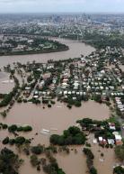
Photo Credit Above: "Rain linked to La Nina halted coal shipments and swamped cotton crops in Queensland earlier this year, after wet weather last year cut sugar output and downgraded east Australian wheat quality. Photographer: Torsten Blackwood/AFP/Getty Images."
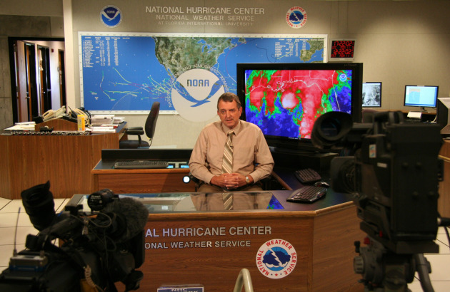
When A Hurricane Approaches South Florida, Will Technology Stand Up To The Storm? The Miami Herald poses the question: "Next time a hurricane hits, families will turn to their smartphones to stay in touch, track the storm and find the shortest gasoline lines. To handle the load, wireless carriers are turning to time-tested disaster plans – but on an exponential scale. The gates will be released on a barnyard-dubbed herd of backup support: cells on wheels (COWS), cells on light trucks (COLTS) and generators on trailers (GOaTS). But will it be enough to handle some 600,000 South Florida households without land lines, plus the seemingly endless hunger to Tweet, Facebook and upload videos of broken trees, gasoline lines and blocked roadways? No one will know for sure until a storm hits. But the violent storms that tore through the country earlier this year provided a look at the demands of a data-dependent age, and the challenges required to meet them. In tornado-ravaged Joplin, Mo., Facebook became a critical channel to finding lost family and asking for help, said Joplin resident Don Lawellin, 54, who used mobile technology to keep in touch. With cable Internet connections down for several days, about two-thirds of the town counted on wireless phones for news. Organizations took to Twitter to spread the word of where to find supplies and emergency stations -- even for re-charging phones. And a cellphone network is the only reason Lawellin’s mother, Edith, is alive today. A service from Alarm.com used wireless networks to send a tornado alert warning to her home security system, waking her up. About a minute later, the only thing left in the duplex was the closet Edith hid in. The heavy use put a toll on wireless services, which were spotty -- but generally worked, though not necessarily on the first few tries."

The Internet Is Killing Local News, FCC Says. An overview of the dilemma facing news outlets from digitaltrends.com: "Despite an overabundance of new media news outlets, the amount of quality local reporting has diminished to dangerous levels, a recently published FCC report shows. A newly released study by the Federal Communications Commission shows that the plethora of online news outlets has led to a serious degradation of local news reporting, reports Cnet. While it’s now easier than ever for citizens to learn about everything from what President Obama ate for lunch to public uprisings in the Middle East, information about local schools, courts, governments and events has become increasingly scarce, according to the 460-page FCC report (PDF) entitled “The Information Needs of Communities: The Changing Media Landscape in a Broadband Age.” Carried out by former US News and World Report national editor Steve Waldman and a team of researchers, the report shows that the number of reporters needed to cover important local events has dropped well below the necessary levels, “The digital tools that have helped topple governments abroad are providing Americans powerful new ways to consume, share and even report the news,” says the report. “Yet, in part because of the digital revolution, serious problems have arisen, as well. Most significant among them: in many communities, we now face a shortage of local, professional, accountability reporting. This is likely to lead to the kinds of problems that are, not surprisingly, associated with a lack of accountability—more government waste, more local corruption, less effective schools, and other serious community problems.” While much of the report’s info isn’t particularly ground breaking — i.e. “[a]n abundance of media outlets does not translate into an abundance of reporting” — it does provide a useful blueprint for rebuilding the crumbling structures of local journalism. According to the report’s estimates, it would take about $1.6 billion to employ the number of reporters needed to cover the “accountability” beats, or $265 million to bring these levels back to what they were in 2000, which was already inadequate for the task, the report says."
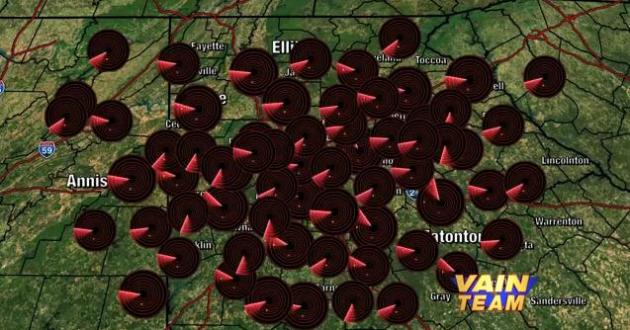
"VAIN Team" Super Duper Weather Promo. This is pretty good, a take-off on local TV broadcast weather promos. Yes, things have gotten a little out of hand. Check out a very well-done weather "promo" for CBSAtlanta here.
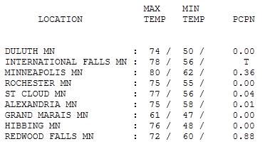
Sunny Start - Thundery Finish. The sun was out long enough for a high of 77 in St. Cloud Friday, 80 in the Twin Cities. By 7pm Tuesday .88" rain had soaked Redwood Falls, .36" in the Twin Cities (and counting).
Paul's Conservation Minnesota Outlook for the Twin Cities and all of Minnesota:
TODAY: Very wet start. Cool with a few spotty showers, T-storms tapering off. Winds: SE 3-8. High: near 70
WEDNESDAY NIGHT: Mostly cloudy and damp, another shower or two. Low: 58
THURSDAY: Partly sunny, probably dry - the only dry day all week? High: 79
FRIDAY: Humid with more T-storms, a few may turn severe late? Low: 59. High: near 80
SATURDAY: Nicer day of the weekend? Partly sunny, stray T-storm far west. Low: 62. High: 82
SUNDAY: Better chance of T-storms, some strong - muggy and warm. Low: 64. High: 86
MONDAY: Sticky, more T-storms, some potentially severe. Low: 67. High: 89
TUESDAY: Still stormy, rain tapers, windy, turning cooler. Low: 65. High: 76 (falling).
In Search of "Normal"
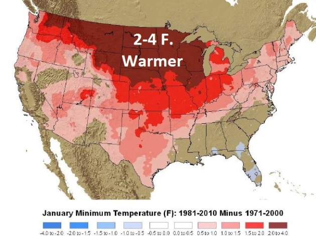
On July 1 NOAA releases the new 30 year running averages for the USA. Over 5,000 weather stations are in the database, same as the old 1971-2000 data, for continuity. So? The 1981-2010 data shows a warming trend since 2000. January "lows" in the new 30-year data set are running 2-4 F. warmer than the 1971-2000 data set for the northern third of the USA. Last winter brought 86.6" snow, but the reality: we're not seeing the volume of arctic air; the number of subzero days & nights we did more than a generation ago.
Then why the reluctant spring? A fading La Nina? An X-Factor we're not even aware of yet? That's the thing about weather and climate: we're still learning, testing new theories, trying to separate out real trends from the noise. More on my blog.
Speaking of noise, the NAM model prints out more than 1" from T-storms, as an "upper air disturbance", a cold swirl aloft, drifts overhead. Clouds & showers keep us cool today, but a warming trend is on the way; 80s will return for the big "Back To The 50s" vintage Auto Show at the State Fairgrounds. Right now Saturday looks like the drier, nicer day; more numerous storms Sunday. 90 isn't out of the question early next week.
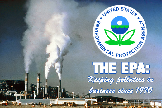
EPA Plans Delay Of Rule On Emissions. The politics of pollution. Is regulating air quality (including greenhouse gas emissions) a job-killer? Industries are rightfully concerned about heavy-handed regulation. Already the EPA is showing signs of pulling back, as reported by the New York Times: "WASHINGTON — Facing intense opposition from Congressional Republicans and industry over a broad range of new air-quality regulations, the Environmental Protection Agency said Monday that it was delaying by two months the release of a proposed rule on greenhouse gas emissions from power plants and other major pollution sources. The rule would have a major impact on the nation’s efforts to reduce emissions of gases blamed for climate change, and its postponement is the latest step by the E.P.A. to slow the issuing of regulations that critics say will slow economic growth, drive up energy costs and reduce employment. Its delay is a tacit admission that the regulations pose political, economic and technical challenges that cannot be addressed on the aggressive timetable that the agency set for itself early in the Obama administration. The agency said it was pushing back the new greenhouse gas proposal to the end of September to allow more time to consider comments from generators of electricity, environmental advocates and others during public-comment sessions. Officials said they still expected to have a final rule in place by May 2012. Scott Segal, a utility industry lobbyist in Washington, said the agency’s caution signaled an understanding that the new rule would have a profound effect on the price, supply and reliability of electricity by forcing modifications to, or the shutdown of, dozens of older power plants. He said the agency had several other major rules pending that would affect power plant operators."

World Needs To Manage Weather Disasters By Preventing Climate Change: Environmentalist. Renowned environmentalist Lester Brown recently gave an interview to the Vancouver Sun: "TORONTO — The world needs to get serious about fighting climate change if it wants to stop an increasing number of natural disasters seen in recent years, because just changing the type of light bulbs we use and recycling our newspapers is not nearly enough to save the environment, cautions a world-renowned author and environmentalist. “The basic point is that, it’s the old adage, an ounce of prevention is worth a pound of cure,” said Lester Brown in an interview last week from the Earth Policy Institute in Washington, D.C. “We know the best way to manage disasters is to prevent them in the first place.” Brown, who has authored more than 50 books on environmental issues, will deliver this ominous message in Toronto at the upcoming 21st World Conference on Disaster Management. According to Brown, the world is ill-prepared and may not survive an impending colossal natural disaster such as flooding, hurricanes, tornadoes, droughts or record-breaking heat waves that are triggered by climate change. “At some point, these disasters will be unmanageable at the societal level,” said Brown, who recently wrote a book on the topic, “World on the Edge: How to Prevent Environmental and Economic Collapse.”

The New Religion Of Global Warming. An Op-Ed from Tom Junod at Esquire: "I have written in this space that American democracy now comes with a guarantee of the right to pick your own apocalypse. But that doesn't mean that everybody's choice is equally valid, as our most recent go-around with the May 21 doomsday deadline demonstrates. If you have to pick your poison, climate change seems the poison to pick. Hell, one may even be forgiven the temptation to ask the question of Republicans — Hey, how's that whole global-warming-is-a-hoax thing working out for ya? — as unprecedented storms and floods give way to unprecedented droughts and heat waves, and the most dire predictions of climate scientists appear, without exception, to be coming to pass. But for most self-identified "conservatives," it will never matter how high the water rises or how convincingly the evidence mounts, because from the start the debate about global warming has never been a debate in which rules of evidence apply. Rather, it has been a tectonic collision of belief systems, the vision of America as a uniquely secular nation and the vision of America as a uniquely Christian one smash together and create earthquakes before they create mountain ranges, and in which secular Americans expressing concern for their children's future and Christian Americans expressing concern for their children's future turn out to be talking about two different things entirely. Last week, for example, was not just the week of Weinergate. It was also the week in which Americans seemed finally to feel the heat — to look around at the storms, and the floods, and the fires, and the droughts, and the rising food prices, and to ask, What's going on? It began with the Times reporting on global crop yields withering even as the global population expands; it continued with Tom Friedman's declaration that the earth (once Flat™) is now Full™; and then ended with a report on the record temperatures recorded in cities from New York to Chicago. At the same time, Mitt Romney announced his presidential candidacy with the heretical acknowledgment that global warming might be a reality, and all in all the country seemed to be slipping back to the place of relative sanity it occupied ten years ago, when even candidate George W. Bush had a climate-change plank in his platform."
Climate Change May Worsen Plague. Here's a real day-brightener of a story. Live Science has the details: "When the climate gets wetter, plagues can get worse, according to a new study that reveals why the plague was much worse in China's north than in the south. The results also suggest that climate change could mean more virulent plagues in northern China and North America, as parts of the globe get wetter. A bacterium called Yersinia pestis, which is carried by rodents, is responsible for three types of plague: bubonic (also called Black Death), septicemic and pneumonic plague. Together, these illnesses have been responsible for the deaths of millions of people the world over, including an estimated third of Europe's population during the Middle Ages. While modern antibiotics can effectively treat plague, thousands of cases are still reported each year to the World Health Organization, and the bacterium has been identified as a possible biological warfare agent."
No comments:
Post a Comment