TODAY: Sticky sun, isolated late-day thunder? Winds: SW 7-12. High: 86
THURSDAY NIGHT: Humid with a better chance of T-storms. Low: 67
FRIDAY: Drier, getting sunnier, still warm. High: 85
SATURDAY: Hot sun, steamy. T-storms north/west, drifting into the metro later in the day. Winds: S 10-20. Low: 70. High: 88
SUNDAY: Damp, showery start, getting sunnier as the day goes on. Still hot. Low: 73. High: near 90
MONDAY: Bright sun, storms stay over Iowa. Low: 70. High: 86
TUESDAY: Sunny, late storms far south. Low: 68. High: 85
WEDNESDAY: Showers, T-storms likely. Low: 69. High: 86
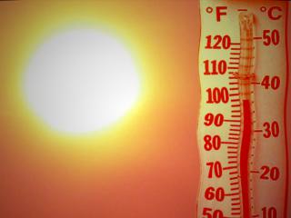
87 F. high in the Twin Cities Wednesday (normal high for July 6 is 83).
254 cooling degree days since June 1, according to the National Weather Service. Average cooling degree days as of July 6 is 191. That means we've used roughly 33% more electricity to cool our homes/businesses than normal since June 1.
.03" rain predicted for this evening (showers/storms forecast to weaken before reaching MSP).
Saturday: next risk of severe storms across the state of Minnesota.
"...University of Iowa engineering professor Witold Krajewski, director of the Iowa Flood Center, compared the situation to a “traffic jam” of water." - article on Missouri River flooding below
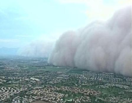
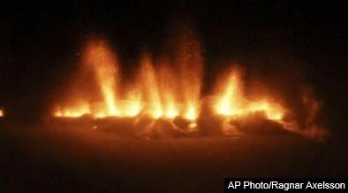
"...KSAZ-TV in Phoenix reported the storm appeared to be roughly 50 miles wide in some spots, and it briefly blanketed the city's downtown at around nightfall. "This was pretty significant," Iniguez said. "We heard from a lot of people who lived here for a number of storms and this was the worst they'd seen." - article below on Tuesday's massive "haboob" in the Phoenix area.

"...What frightens me is that a majority of people in Oklahoma believe Inhofe knows more than 2,000 climate change scientists (IPCC), OU professors, DARPA researchers, the DOD, FEMA, the USDA, and insurance company risk professionals." - article on Senator James Inhofe, vocal climate skeptic, below.

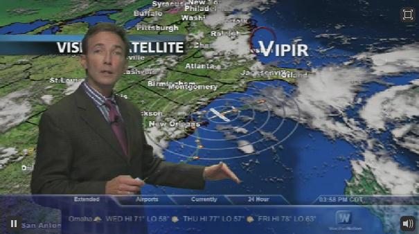
WeatherNation, The Channel. We've launched a new 24/7 national HD weather channel from our studios in Excelsior (corporate office in Denver), focusing on all-weather, all the time. A few details below.
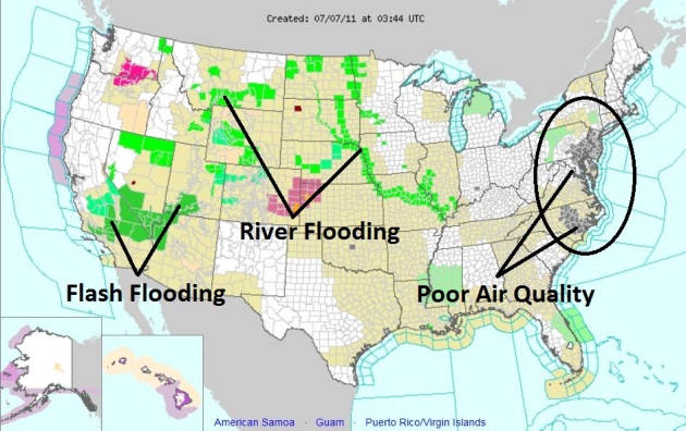
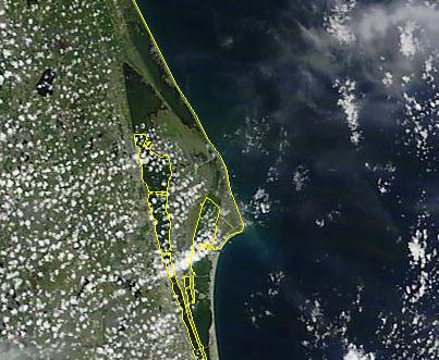
Flooding & Poor Air. NOAA's watch/warning map late Wednesday showed air quality alerts from New York City southward to Raleigh. River flooding was a problem on the Missouri River and its tributaries, flash flooding from monsoon rains a threat in California, Nevada (Las Vegas area) and parts of southern Utah.
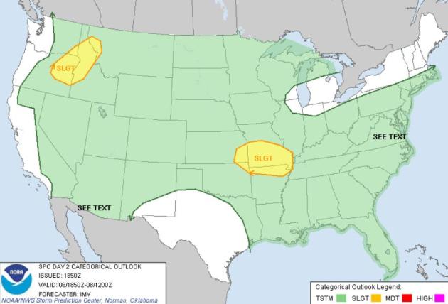
Thursday Severe Risk. SPC has a slight risk of isolated severe storms over Missouri and northern Arkansas, another threat area over Idaho and eastern Oregon, which is odd for early July.
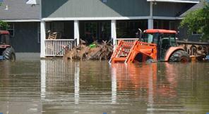
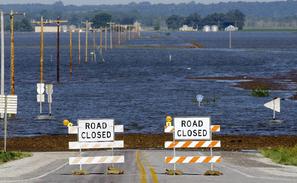
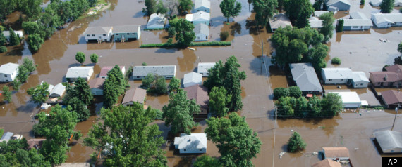
Smaller Midwest Rivers A Threat. Flooding on the Missouri is also impacting smaller tributaries running into the Missouri, a web of flooded fields and roads that continues to expand. The Times Leader has a comprehensive story: "LINCOLN, Neb. — In a season of flooding by some of the nation’s biggest rivers, it’s streams most Americans have never heard of that could cause some of the worst problems in the Midwest. Hundreds of tributaries that feed the congested Missouri River face a greater-than-normal flood risk this summer because of water levels that have kept them from draining. The Missouri is expected to remain near historic highs for months, which means the threat will remain through summer— a season when the Midwest often is beset with thunderstorms that can quickly dump heavy rain. University of Iowa engineering professor Witold Krajewski, director of the Iowa Flood Center, compared the situation to a “traffic jam” of water. It started with the sustained release of massive amounts of water from dams on the upper Missouri, caused by spring rain and a heavy Rocky Mountain snowpack that filled reservoirs. “It’s like a football game and baseball game getting out at the same time,” Krajewski said. “There are all these cars trying to move. It doesn’t take long before drivers can’t get out of the side streets.”
Wednesday High Temperature Records:
- Waco, TX: 103 (tie) Old record: 103 in 1998
- El Cajon, CA: 92 (tie) Old record: 92 in 1988
- Camarillo, CA: 87 Old record: 85 in 1981
Sizzling Factoids:
- Wichita Falls, TX has had 40 days above 100 degrees so far this year
- 28 of those were in June alone.
- San Angelo, TX has had 40 days above 100 degrees so far this year
- 26 of those were in June alone.
- Oklahoma City, OK has had 16 days above 100 degrees so far this year.
- Amarillo, TX has had 16 days above 100 degrees so far this year.
- The Atlantis Space Shuttle launch may not happen on the planned time of 11:26 a.m. ET July 8 due to the weather.
- A tropical wave from the Caribbean is expected to hit Florida with a lot of tropical moisture.
- The shuttle launch, therefore, has 70 percent chance of canceling on July 8. It has a 60 percent chance of canceling on July 9 and a 40 percent chance of canceling on July 10.
- In all, there is a 17 percent chance that it won't launch at all by July 10.
- A 2007 Associated Press analysis found that only 40 percent of space shuttles launched on time. Of the failures to launch on time, more than 50 percent of them were caused by technical failures and about one-third were caused by unsuitable weather.
- A NASA spokesperson said each canceled launch after the external fuel tank has been loaded costs $1.3 million.
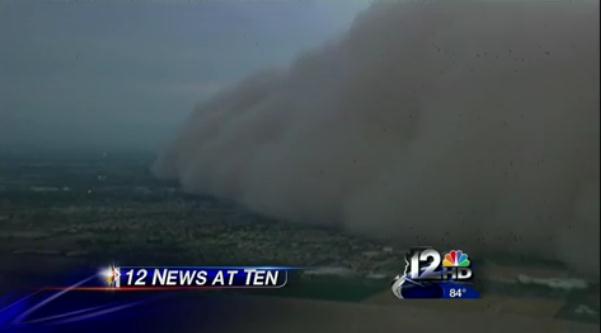
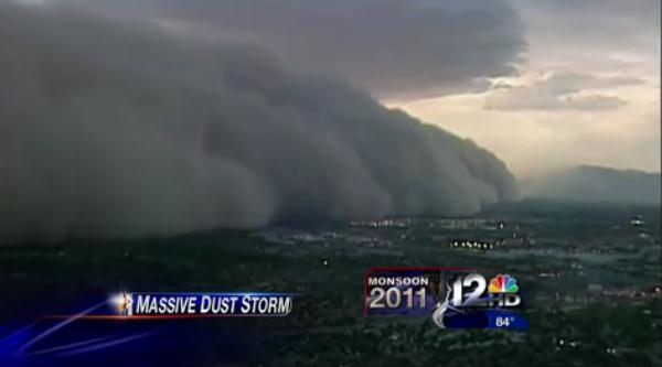
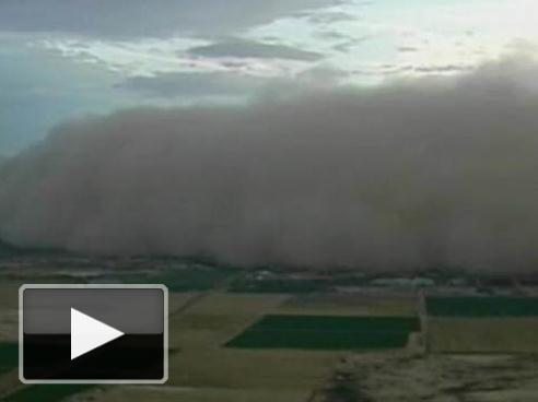
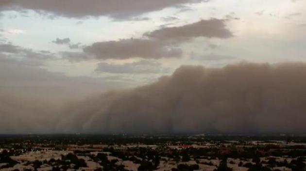
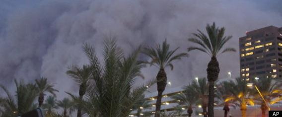
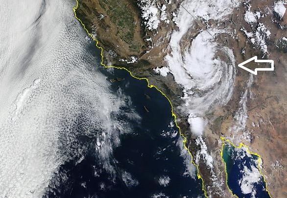
Monsoon. NASA's MODIS high-resolution low-orbiting satellite showed a cyclonic swirl of thunderstorms over southern California. From space it almost looked like a mini-hurricane (!) Extreme heat over the desert creates strong thermals of warm, rising air. Pacific moisture streams inland to replace the rapidly rising air, creating towering thunderheads capable of flash flooding. Collapsing downdrafts can go on to produce haboobs, like the sandstorm that invaded Phoenix late Tuesday.
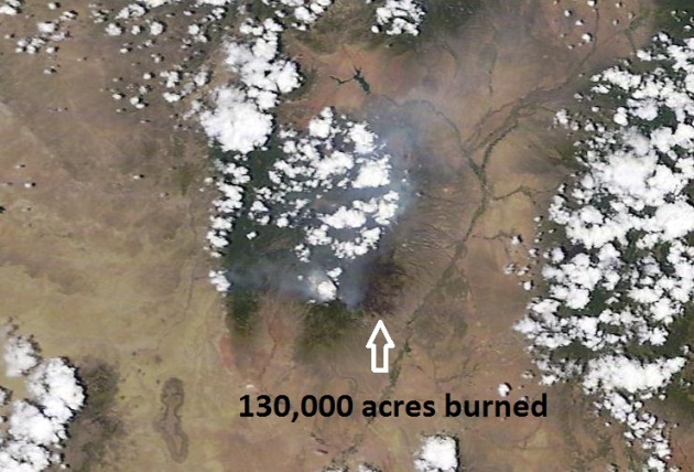
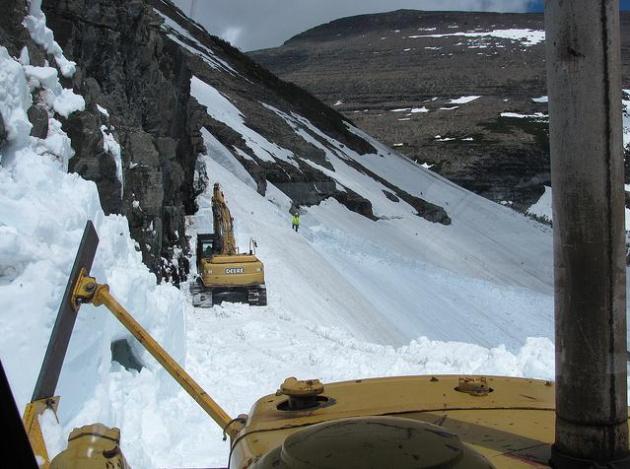
Las Conchas Fire Update. The blaze burning near the Los Alamos Nuclear Facility is only partially contained. Here is an update:
- It’s still smoky in northern New Mexico, but life is returning to normal as thousands of employees are back at work after a wildfire had threatened the nation’s premier nuclear weapons laboratory.
- The Las Conchas fire had charred more than 204 square miles Wednesday. Firefighters have contained 30 percent of the blaze and the danger to Los Alamos National Laboratory and the town that surrounds it has waned.
- Scientists and technicians will spend the next few days assessing the status of key research projects.
- According to the latest infrared mapping, the Las Conchas fire had burned 130,691 acres and was still 30 percent contained.
- So far 63 residences have been destroyed since the fire began with a downed tree falling into a power line on June 26, and another 410 residence remain threatened.
- A total of 32 outbuildings have been destroyed, and 45 are threatened, and five injuries have been reported to date.
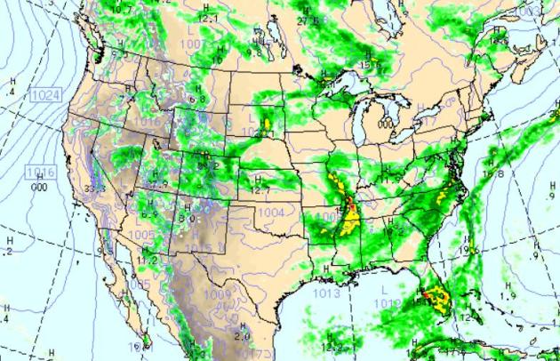
Thursday Rainfall. Strong/severe storms are forecast to flare up over the Middle Mississippi Valley, more heavy T-storms from D.C. and Baltimore southward to the Carolinas as a tropical wave pushes westward from the Atlantic. South Florida will see heavy rain and embedded T-storms capable of some 2-4" rains. More storms will pop from the Twin Cities southwestward to Denver, a growing monsoon effect sparking scattered storms over Arizona and Utah. Rain showers over the Rockies will accelerate snowmelt and aggravate the ongoing flood situation across much of the west.
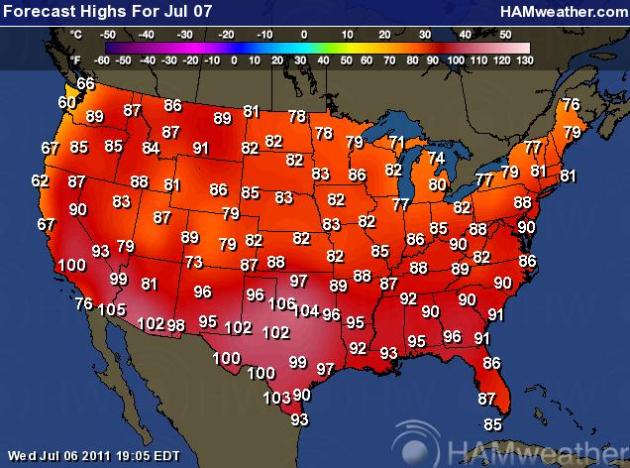
Thursday Highs. I feel like Bill Murray in the movie "Groundhog Day". Every day is the same. Comfortable 70s over the northern tier states, while the south and southwest sizzles above 100 degrees. Seattle has gone 304 days without seeing 80 degrees. Not today.
REYKJAVIK, Iceland – One of Iceland's most feared volcanoes, Hekla, looks ready to erupt, with measurement instruments showing likely magma movement, an Icelandic geophysicist said Wednesday. The volcano is close to the ash-spewing Eyjafjoell, which last year caused the world's biggest airspace shut down since World War II, affecting more than 100,000 flights and eight million passengers. The Iceland Civil Protection Authority said it was closely monitoring the situation. "The movements around Hekla have been unusual in the last two to three days," University of Iceland expert Pall Einarsson said. While this might not necessarily mean an immediate blast, "the volcano is ready to erupt," he stressed. "The mountain has been slowly expanding in the last few years because of magma buildup," he explained. The volcano, dubbed by Icelanders in the Middle Ages as the "Gateway to Hell," is one of Iceland's most active, having erupted some 20 times over the past millennium, most recently on Feb. 26, 2000."
- Scientists are monitoring unusual underground activity that could signal an eruption at the Hekla volcano in southern Iceland.
- University of Iceland geophysicist Pall Einarsson said Wednesday that magma appears to be moving deep beneath the volcano. He says that does not necessarily mean an eruption is imminent. But scientists expect Hekla, one of Iceland's most active volcanoes, to erupt soon.
- In the past few decades, Hekla has erupted about every 10 years, most recently in February 2000.
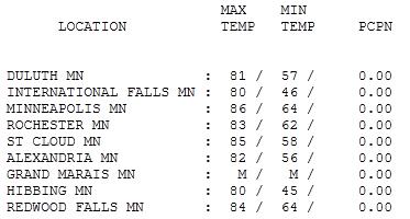
Another Photo-Finish. What a Wednesday, blue sky, gentle breezes, reasonable humidity levels, all thanks to a fresh transfusion of Canadian air. Highs ranged from 80 at International Falls & Hibbing to 85 in St. Cloud, 87 in the Twin Cities, a degree warmer than the official climate report, which came out around 7 pm yesterday.
Forecast: More Weather
No, I don't pretend to have the answer key, but over the years I've told aspiring entrepreneurs that the most important attribute may just be flexibility, being open to new opportunities; cultivating a team of smart people that can turn on a dime. When I left WCCO-TV over 3 years ago I started a company that outsources weather to TV stations and media outlets like KARE-11 and Conservation Minnesota. Under the heading "man plans, God laughs" we just recently launched a new, 24/7 HD weather service, called "WeatherNation". The national channel & website are up now. Hopefully with continued support, available via your local cable system in the very near future. No, I didn't see this coming 3 years ago. The timing is good. With increasingly extreme weather around the USA we're excited to be offering a true alternative.
Expect sticky sun today, a few PM T-storms north & west of MSP. We dry out a little Friday before the next swarm of T-storms rumbles into the state over the weekend. The best chance of Saturday storms will come up north; a damp, showery start Sunday may give rise to gradual clearing. Not quite as spectacular as last weekend, but highs surge through the 80s to near 90 - should be warm enough for the lake. After a slow start, summer is (finally) here!

Climate Stories...
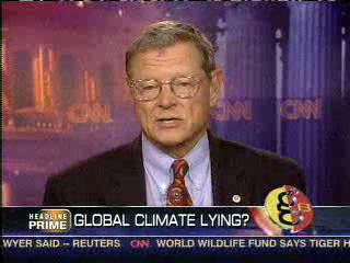
Evans: Oklahoma Governor Should Check On His State's Weather. Here's an interesting Op-Ed at the times-leader.com: "Oklahoma Sen. James "climate change is a hoax" Inhofe, the most outspoken climate change skeptic in Congress, was scheduled to be the kickoff speaker at the nation's most prominent gathering of climate change skeptics (funded by the oil industry) in Washington. Inhofe sent a note expressing regret that he could not attend, saying he was "under the weather." Just before last month's meeting, the USDA released the Drought Monitor Report stating that the western third of Oklahoma is in an "exceptional drought," the worst category. Oklahoma City had temperatures of 90 degrees or above every day in June. The average daily temperature statewide was the second-warmest on record. Oklahoma's economy is dependent on federal funds from the Department of Defense which operates a large Army base, two Air Force bases, and a munitions factory in a state of just over three million people. While Inhofe was calling climate change a hoax, the DOD released a study declaring climate change a very real national security issue. The report stated, "The nature and pace of climate changes being observed today and the consequences projected by the consensus scientific opinion are grave and pose equally grave implications for our national security....It is ironic that the guy who calls climate change a hoax is contradicted by his state's weather, the Department of Defense, insurance company contributors to his campaigns, the USDA, FEMA, and even his state's premier university. What frightens me is that a majority of people in Oklahoma believe Inhofe knows more than 2,000 climate change scientists (IPCC), OU professors, DARPA researchers, the DOD, FEMA, the USDA, and insurance company risk professionals."
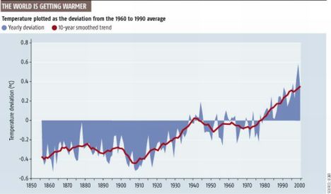
Lukewarmers, Denialists And Other Climate Change Skeptics. Here's a timely post from Ronald Bailey at reason.com: "Climate change politics is very nasty. So nasty, in fact, that the mud started flying even before the start of last week's Sixth International Climate Change Conference (ICCC6) in Washington, D.C. Hosted by the free market Heartland Institute, the conference gathers the world's climate change skeptics and their heterodox friends—and controversy reliably ensues. The day before the conference started, the left-wing Center for American Progress (CAP) arranged to have a media teleconference [MP3] as a kind of pre-emptive strike. The CAP teleconferencers included Joseph Romm who runs CAP’s climate blog, Pacific Institute hydroclimatologist Peter Gleick, and former House Science Committee chair Sherwood Boehlert (R-NY). Romm characterized the ICCC6 as part of “a dwindling number of increasingly vocal people who spread disinformation on climate science and who attack and harass climate scientists.” Romm then cited a June 28 statement of concern issued by the American Association for the Advancement of Science (AAAS) which deplored the “harassment, death threats, and legal challenges” being faced by some climate scientists. The AAAS specifically mentioned recent Freedom of Information Act (FOIA) inquiries about the work done by climatologist Michael Mann, the principle scientist behind the “hockey stick” paleoclimate data suggesting a dramatic recent rise in average global temperatures. The AAAS letter concludes, “We are concerned that establishing a practice of aggressive inquiry into the professional histories of scientists whose findings may bear on policy in ways that some find unpalatable could well have a chilling effect on the willingness of scientists to conduct research that intersects with policy-relevant scientific questions.” I agree."

No comments:
Post a Comment