Paul's Conservation Minnesota Outlook for the Twin Cities and all of Minnesota:
TODAY: Plenty of sun, no pulsating blobs on Doppler. Winds: SE 7-12. High: 86
FRIDAY NIGHT: Warm and muggy, storms far northern/western MN. Low: 70
SATURDAY: Sticky sun much of the day, T-storms late. Winds: S 10-20. High: 88
SATURDAY NIGHT: Showers and T-storms likely, some heavy/severe. Low: 73
SUNDAY: Storms linger, still very sticky, some strong/severe? Winds: SW 10-15. High: 85
MONDAY: Sunny, less humidity. Low: 71 High: 87
TUESDAY: Partly sunny, probably dry. Low: 67. High: 83
WEDNESDAY: Storms return, especially PM hours. Low: 66. High: 81
THURSDAY: Humid, scattered storms likely. Low: 67. High: 85
87 F. high in the Twin Cities Thursday.
.01" rain fell on St. Paul yesterday.
Isolated storm possible today.
Severe storm risk Saturday PM, again late Sunday.
 "...Steve Scolnik at Capital Climate analyzed the data from NOAA’s National Climatic Data Center and found U.S. heat records in June outnumbered cold records by 2706 to 251 — nearly 11 to 1." -
 article on June heat below.
"...
Forecasters say this season could rival the Great Flood of 1993, when the upper Midwest endured persistent, record-breaking floods from April through August, impacting nine states and causing more than $25 billion in damages (adjusted for inflation)." - NOAA article below on the severity of summer flooding.
"Car-Mageddon". Uh oh. The (always-jammed) 405 will shut down the weekend of July 17-17, and Los Angeles is going into an almost
war-like mode, preparing for some of the worst traffic jams in the city's history. Details below.
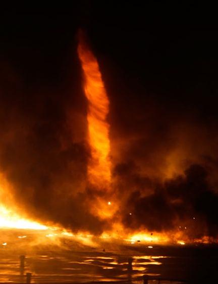
Photo Of The Day: "Firenado". As if a tornado wasn't bad enough, let's add fire to the mix!
National Geographic has the details: "
A fire tornado whirled above a burning plastic-processing plant during a huge conflagration outside Budapest, Hungary, on March 3, 2011 (pictured). (Related: "Fire-Tornado Pictures: Why They Form, How to Fight Them.") The cause of the fire remains unknown, and no casualties were reported, according to the Reuters news service. Also known as fire whirls, fire devils, or even firenados, fire tornadoes form when high heat and turbulent winds together spur whirling eddies of air, mechanical engineer Jason Forthofer told National Geographic News in September. These eddies can tighten into a tornado-like structure that sucks in burning debris and flammable gases, said Forthofer, of the U.S. Forest Service's Missoula Fire Sciences Laboratory in Montana. The fiery core inside the swirling "tube" of winds is usually about 1 to 3 feet (0.3 to 0.9 meter) wide and five to ten stories tall. At the extreme, though, fire tornadoes can stretch dozens of feet wide and more than a hundred stories tall, Forthofer said. (Related: "Giant 'Tornadoes' Seen Erupting From the Sun.") The firenadoes, he added, aren't so much rare as rarely reported—perhaps because they tend to occur during wildfires, rather than in urban centers."
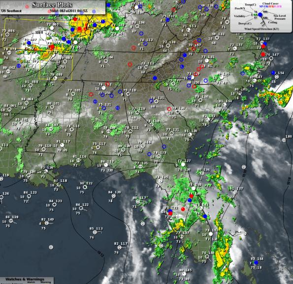
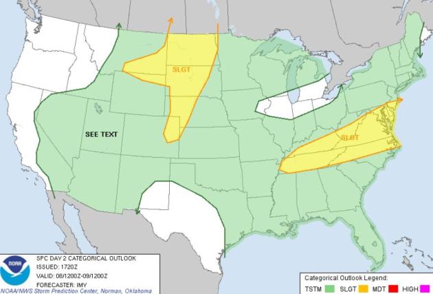 Friday Severe Risk
. A few isolated severe storms may fire later today from the Mid Atlantic states westward to Memphis, a second risk area from northeastern Colorado into the Dakotas.
 Saturday Severe Threat
. By Saturday the risk of hail/damaging winds shifts from the central Plains iinto southern and central Minnesota and western Iowa.
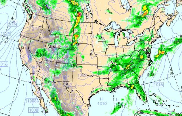 Friday Rainfall
. The latest WRF/NAM model shows potentially severe storms rumbling across the Dakotas later today, a broad region of heavy showers and storms from Florida up the east coast into upstate New York, puddles predicted westward to Memphis and Little Rock. Most of the west stays dry - more 100-degree sunshine across Texas.
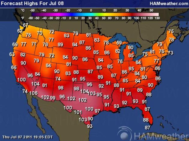 Another Free Sauna For The South
. It's deja vu all over again. More 100s from California to Texas, comfortable 70s for New England. cool 60s from the Bay Area north to Portland and Seattle.
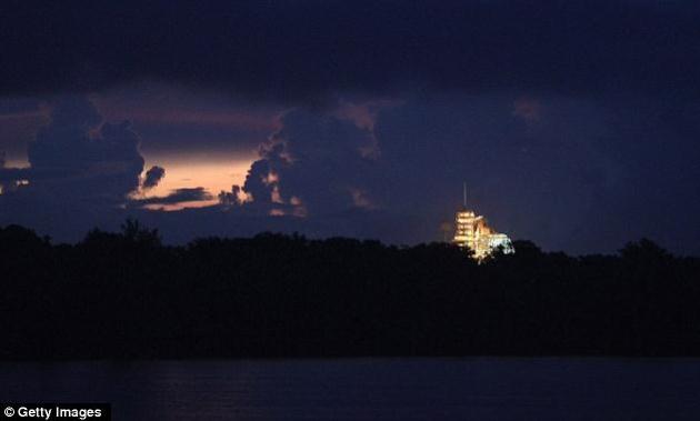
Atlantis Space Shuttle Launch: 70% Probability of Rain-Delay Today. It doesn't look good for today's (final) launch of the Space Shuttle, a tropical wave over Florida producing widespread T-storms with locally heavy rain, gusty winds and cloud to ground lightning - not exactly favorable conditions for a rocket launch. The U.K.
Daily Mail has more details: "
The weather isn't cutting NASA any breaks, not even for tomorrow's scheduled last space shuttle launch. Bad weather is expected, and forecasters said there's a 70 per cent chance that rain or thunderstorms will prevent Atlantis from flying. No hail or other severe conditions are anticipated, just 'a lot of nuisance weather', said shuttle weather officer Kathy Winters. While the weather is set to improve slightly over the weekend, Friday's forecast would have to get worse before he'd call off the launch, mission management team leader Mike Moses said. A rain-free, storm-free zone is needed 23 miles around, among other things, in order for Atlantis to take off."
- By mid-afternoon, Kennedy Space Center was hit by a series of rain squalls – and at least one lightning strike roughly a third of a mile from the shuttle's launch pad. NASA officials immediately dispatched technicians to check for damage, though there were no immediate indications of any.
- Nonetheless, preparations for the launch remained underway.
- The Rotating Service Structure protecting Shuttle Atlantis was pulled away Thursday around 30 minutes later than planned due to the weather.
- Friday's launch of the space shuttle Atlantis remains iffy, with NASA saying Thursday morning there is a 70-percent chance that the launch may be delayed. And chances for bad weather scrubbing a Saturday lift-off are 60 percent.
- A tropical wave has moved into the Space Coast area from the south, threatening rain, lightning and overcast conditions Thursday and continuing into Friday, when Atlantis is scheduled to lift off at 11:26 a.m. ET.
- If late-morning weather forces NASA to scrub the launch, Saturday may be nearly as problematic for an 11:02 a.m. launch. If NASA reschedules for Sunday, launch time would be 10:38 a.m.
Tropical Wave: Florida Soaking. Here's more information on the tropical system generating heavy thunderstorms and flooding rains over the southeast. Parts of Florida have gone from drought to flood in the the span of 72 hours.
- An elongated low pressure system located about 300 miles southwest of Tampa, Florida has become a little better defined during the past few hours.
- In addition, surface pressures have decreased over the eastern Gulf of Mexico during the last 24 hours.
- Environmental conditions are expected to become marginally conducive for some additional development of this disturbance.
- There is a 40% chance of this system becoming a tropical or subtropical cyclone during the next 48 hours as it moves slowly northward or north-northeastward.
- Regardless of development, this weather system will produce periods of locally heavy rainfall across most of the Florida Peninsula and the eastern Florida Panhandle during the next couple of days.
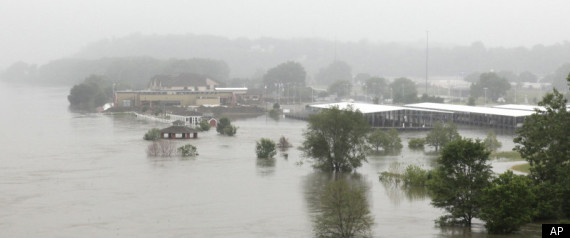
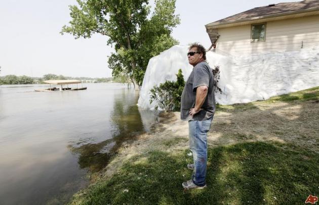
Widespread Flood Threat Could Linger Through Summer - Rival 1993? NOAA has a good summary of the scope and severity of ongoing flooding along the Missouri River and its tributaries: "
Many rivers in the upper Midwest and northern Plains remain above flood stage, and the threat for more flooding will continue through the summer, forecasters at NOAA’s National Weather Service said today. With rivers running high and soils completely saturated, just a small amount of rain could trigger more flooding, including areas that have already seen major to record flooding. NOAA’s Climate Prediction Center is forecasting above-normal rain in most of these vulnerable areas in the next two weeks, and above-normal rainfall in much of the region in the one- and three-month outlooks. Adding to the flood threat will be the rising temperatures over the Rockies, which will release the water from the remaining snowpack. “The sponge is fully saturated – there is nowhere for any additional water to go,” said Jack Hayes, Ph.D., director of NOAA’s National Weather Service. “While unusual for this time of year, all signs point to the flood threat continuing through summer.” Forecasters say this season could rival the Great Flood of 1993, when the upper Midwest endured persistent, record-breaking floods from April through August, impacting nine states and causing more than $25 billion in damages (adjusted for inflation). As flood threats continue in these areas, NOAA’s partners at the Federal Emergency Management Agency are continuing to support the response efforts in all of the impacted states. And they continue to urge all residents to take steps now to get ready for severe flooding and other hazards."
Photo credit above: (Credit: With permission from Rick Murray.)
Summer Floods Threaten Record Levels As Rain Predicted.
Reuters has more on the ongoing flood threat: "
With rivers still running above flood stage and soils saturated, forecasters predicted on Wednesday this summer flooding season could rival the worst in United States history. In the "Great Flood of 1993," record-breaking floods from April to August cost more than $25 billion in damages in at least nine states. But due to current high water levels and soaked soil, just a small amount of rain could trigger more flooding in areas that have already seen record flooding this 2011 season, the National Weather Service reported Wednesday. These factors indicate the flooding threat will continue through the summer, and potentially rival the flood of nearly two decades ago. "There is nowhere for any additional water to go," Director of the National Oceanic and Atmospheric Administration's NWS Jack Hayes said in the NOAA statement. "While unusual for this time of year, all signs point to the flood threat continuing." NOAA's Climate Prediction Service has forecasted above-average rain in already-vulnerable areas of the upper Midwest and Northern Plans in the next two weeks, and for much of the region in monthly outlooks. Rising temperatures over the Rockies will add to the flood threat, releasing water from the remaining snowpack."
Throughout the rest of the summer, the highest flood risk areas include:
- North Central U.S. including Souris River (North Dakota) and Red River of the North (border of North Dakota and Minnesota), Minnesota River (Minnesota), Upper Mississippi River (Minnesota and Iowa), and Des Moines River (Iowa)
- Lower Missouri River from Gavin’s Point (Nebraska and South Dakota border) downstream along the border of Nebraska and Iowa, continuing through the borders of Kansas and Missouri then through Missouri to the Mississippi River
- Tributaries to the Lower Missouri including the James and Big Sioux Rivers in North Dakota
- Lower Ohio River Valley including the White, Wabash and lower Ohio River
- East of Rockies: North Platte River in Colorado, Wyoming and Nebraska and Yellowstone River in Wyoming and Montana
- West of Rockies: Utah and Colorado
* information above courtesy of
NOAA.
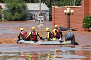
 Heavy Rains Pound Denver Area, Street Flooding Traps Cars.
 The Denver Post has the latest on severe storms that roared through the Denver area late Thursday: "
A severe thunderstorm is dropping heavy rain, flooding streets, swamping cars, sweeping away manhole covers and causing power outages as it moves through the metro area. Denver Fire Department crews has made scores of water rescues as more than 10 cars at a time found themselves trapped in rising, fast water, said Lt. Phil Champagne. "It's widespread through the city, but the northeast quadrant has been hard hit," he said. "But it's been all over the board, and it's been fast and furious all afternoon long." Xcel Energy reported that, as of 8 p.m., 18,000 customers were still without power. Xcel spokesman Mark Stutz said Xcel called in extra crews to help restore the power. The National Weather Service reported numerous gauges indicated 2 inches of rain fell on parts of Denver in less than an hour between 4:15 p.m. and 5:15 p.m. Denver and Aurora are under a flash flood warning until 10:15 p.m. for parts of Denver, Arapahoe and Adams counties. A severe thunderstorm warning expired at 6 p.m. The National Weather Service also issued a flash flood warning for central Boulder County until 9:15 p.m. "This is a life-threatening situation," the National Weather Service in Boulder stated. "Heavy rainfall will cause extensive and severe flash flooding of creeks, streams and ditches the Fourmile burn area."
 Thursday Records:
- Oklahoma City, OK: 108 Old record: 106 in 1996
- Fort Smith, AR: 107 Old record: 106 in 1964
- Tulsa, OK: 104 Old record: 103 in 1917
- Record coldest highs
- Naples, FL: 81 Old record: 85 in 1968
- Miami, FL: 81 Old record: 83 in 1933
- West Palm Beach, FL: 82 (tie) Old record: 82 in 1988
* Showers and heavy T-storms kept temperatures 10-15 degrees cooler than they would have been across south Florida, had the sun been out for a few hours.
 Number of Record Highs In June:
Houston - 7
Number of Record Highs In June:
Houston - 7
Birmingham - 6
Amarillo - 6
Mobile - 5
Savannah - 4
Memphis - 4
St. Louis - 4
Washington D.C. - 3
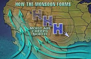
Southwest Monsoon Kicks Off: More Rain In 9 Minutes Than Last 9 Months.
AccuWeather has the latest on the monsoon effect - from drought to flood in the blink of an eye: "
The monsoon is now in full swing across the Southwest, as evidenced by Tuesday's thunderstorm activity that brought flash flooding and a monster dust storm to Arizona. Thunderstorms will continue to be more widespread across the Southwest through the end of the week with a continuing risk of flash flooding, wind damage, hail and dust storms. In Douglas, Ariz., more rain fell in just nine minutes Wednesday afternoon than over the past nine months, according to the National Weather Service Forecast Office in Tucson, Ariz. Douglas picked up 0.30 of an inch Wednesday. From Oct. 1, 2010 to Tuesday July 5, 2011, only 0.29 of an inch fell. Douglas is suffering exceptional drought conditions."
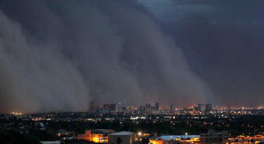
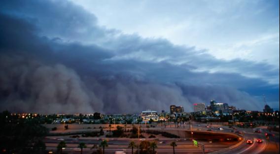
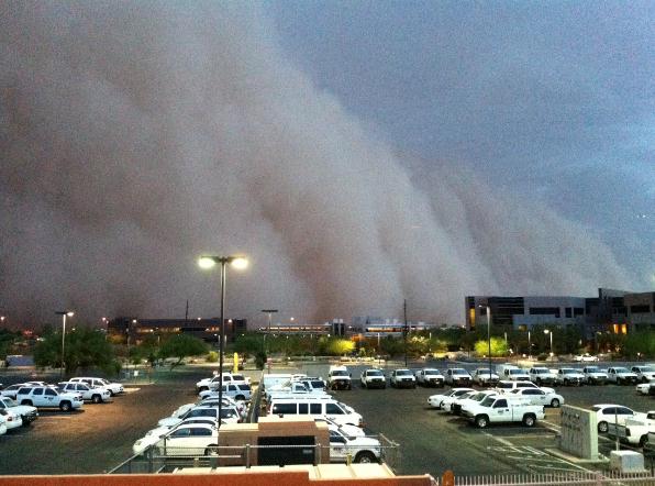
Phoenix Dusts Off After Giant Sandstorm Whips Through. For a few brief minutes late Tuesday it must have looked like the end of the world in the Phoenix area, the entire metro area enveloped in a black, churning cloud of dust and sand. The
New York Times has more information "
Phoenix residents awoke on Wednesday to a thick layer of dust on their cars, their streets and just about everything else outside after a giant sandstorm more than a mile high roared through the city. The storm on Tuesday evening grounded airplanes, led to traffic tie-ups and set off a wave of coughing across the Valley of the Sun. At the height of the storm, visibility was reduced to zero. While sandstorms, or haboobs, are not uncommon in Arizona and other desert areas, the size of this one and the sheer amount of dust it raised were highly unusual. “The magnitude of this event was really exceptional,” said Ken Waters, a warning coordination meteorologist with the National Weather Service in Phoenix. “People who have lived in Arizona for 30, 35 years say this is the biggest one they’ve seen.” The storm was driven by 60-mile-an-hour winds that collected the sand into a rolling brown cloud and sent it moving across the city, briefly shrouding the lights of downtown Phoenix as it passed through. The sandstorm ran for about 150 miles before dissipating, and at its peak might have grown to as large as 100 miles wide and more than one mile high."
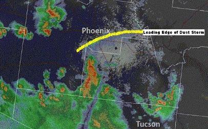
How A Tucson T-storm Started The Phoenix Haboob. Here's a meteorological explanation for Tuesday evening's (historic) sandstorm in the Phoenix area, from
KOLD-TV meteorologist Erin Jordan: "
TUCSON, AZ (KOLD) - The massive dust storm that struck Phoenix on Tuesday began in Tucson. A severe storm that moved across Tucson Tuesday afternoon produced wind gusts estimated at 70 MPH. These winds moved to the northwest at around 30 to 40 MPH, picking up dust and dirt from the desert and farm fields of Pinal County. The combination of abandoned or retired farmland in Pinal County, along with on-going drought, meant the land was very dry and lacked vegetation that would keep the soil in place. The dust storm turned into a 'haboob' - the informal name for a massive dust storm. Haboob is an Arabic word. Massive dust storms are fairly common in the Middle East and Sahara. The Phoenix National Weather Service office released this detailed report on the storm. Radar actually picked up the dust storm as it moved through Pinal County towards Phoenix. Below is a radar image taken at 7:45 PM showing the original severe storm now east of Tucson and the wall of dust approaching Phoenix. "
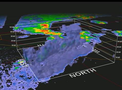
3-D Radar, Wind Graphs From 80 mph Phoenix Wind Storm. Jesse Ferrell from
WeatherMatrix (a division of AccuWeather) has a great explanation of Tuesday's haboob in the Phoenix area, including a 3-D visualization of the advancing wall of sand and dust: "The dust was tossed into the atmosphere over 20,000 feet into the air, as shown by the 3-D radar I pulled from
GRAnalyst - in fact this is a rare case where what you see on the radar (
hi-res |
static |
cross-section) looks exactly like what you see in reality, because it is picking up the dust as it overtakes the city. The dust storm was caused by a thunderstorm "outflow boundary" (see more below)."
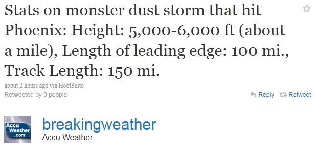
Major Dust Storm Moves Through Arizona. The Phoenix office of the
National Weather Service has a good overview of Tuesday evening's "haboob": "
A very large and historic dust storm moved through a large swatch of Arizona during the late afternoon and evening hours of July 5, 2011. Widespread reports of near zero visibility and winds gusting over 50 MPH (80 kph) were received by the NWS Phoenix office. Based on radar data, it is estimated that this dust storm reached a peak height of at least 5000 to 6000 ft (1500 to 1800 m). The aerial coverage was very expansive, with the leading edge stretching for almost 100 mi (160 km). The distance traveled was at least 150 mi (240 km)."


No comments:
Post a Comment