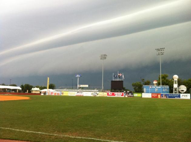
Saturday: next chance of showers and T-storms in the Twin Cities metro.
114 in Little Rock Wednesday afternoon, the hottest temperature ever recorded.
107 in Kansas City, Missouri Tuesday, the hottest temperature since 1984.
90-degree "lows"? Wednesday morning, under an Excessive Heat Warnings, much of metro Phoenix saw minimum temperatures stay above the 90 degree mark across much of the metro area. Ouch.
Electric Emergency declared in Texas, due to the extended heat wave.
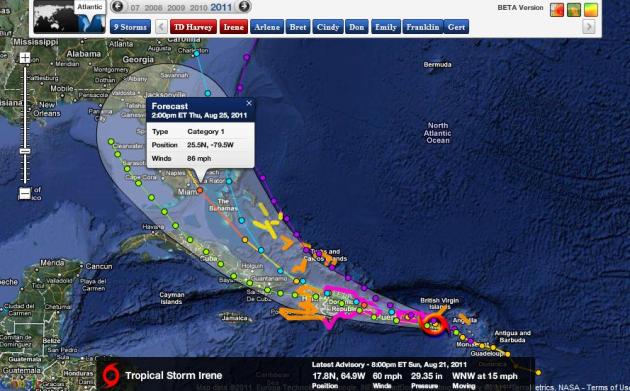
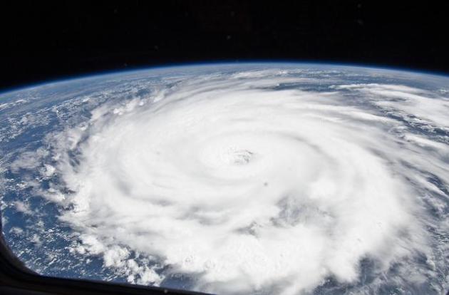
A (Very) Close Encounter With The Sunshine State? Tropical Storm Emily weakened overnight, sustained winds in the 40-50 mph range, but strengthening is likely as the core of the storm passes over warm water near the Turks, Caicos and Bahamas. At least one model (GFDL) brings Emily into the Miami area late Friday night as a hurricane with 91 mph winds. Other models keep the core of the storm 100-200 miles east of Florida, but it may be a very close call. Hurricane Watches may be issued for Florida as early as midday today. Map courtesy of NHC and Ham Weather.

"...But perhaps one of the most unexpected factors that influences people's opinions on climate change is what the weather looks like outside. Columbia's Li surveyed Americans and Australians and found that when it's hotter outside, people are more likely to be worried about global warming. When it's cooler, that worry dissipates." - something I've observed the last 20 years, highlighted in an MSNBC article below.
"...Arguing about the facts of climate change, and who's right and wrong, and assigning loaded labels like 'believer' (good) and 'denier' (bad), won't get us anywhere, because the argument is about something more important, something deep underneath. Trying to get somebody to change their mind on climate change, or any of the polarized issues of the day, is in effect asking them to change their underlying self-identities....We have stop making climate change a zero sum if-you-win-I-lose battle. We have to frame the issue in ways that work within everybody's underlying cultural/tribal perspectives. We have to realize that answers are more likely to be found, and solutions are more likely to be reached, if the goal is finding common ground, to one of the most serious threats humans - all of us - have ever faced."
- article on climate change and ideological beliefs and self-identity in an article below.
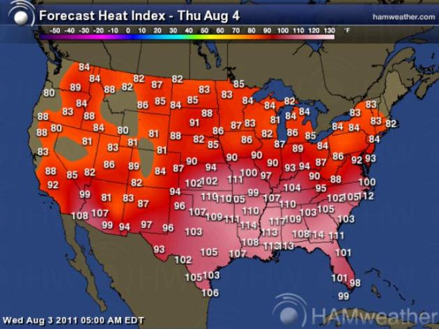
A (Slowly) Shrinking Heat Bubble. The southeastern third of America will continue to broil today, the combination of air temperature and dew points creating a heat index in the 105-115 range from the Southern Plains eastward to the Carolinas and Florida. Map courtesy of Ham Weather.
- There are 18 states with temps at or above 100 today. That is 3 more states than what we saw yesterday.
- Ft. Smith, AR broke their all-time record high reaching 115 degrees.
- The previous all time record was set just yesterday at 113.
- Before that, the all time record was 111 set on Monday, as well as in 1954.
- Power outages reported in the 2 PM hour in Ft. Smith, possibly related to the heat.
- UPDATED: At 2:40 PM, Little Rock hit 114, making a new all time record temperature for the city. Temperatures are still expected to rise through the afternoon Records date back to 1877 for Little Rock. This is only their 3rd day of 110+ heat on record!
- At 1:24 PM, Memphis, TN, hit 106, breaking the previous record of 103 set last year.
- Wichita Falls has seen a high over 100 for 43 straight days. That's a new record.
- Even more surprising, that 43 day streak of 100+ at Wichita Falls would actually be 63 days if not for June 2, when they reached a high of *only* 98.
- Oklahoma City hit 107, a new record.
- Brings 100 degree total for the year to 41, the record is 50
- This is the first time since the Dust Bowl Tulsa has had 3 straight days of 110s.
- Record is 5 straight days (Aug. 9-13, 1936).
- The city of Houston has activated its heat emergency plan today -- it is activated when the the heat index, a computation of air temperature and humidity, reaches 108 on two consecutive days.
- High-risk groups such as adults age 55 and older, children under the age of five and people with chronic illness are urged to stay inside air-conditioned buildings between 1pm and 5pm, the hottest part of the day.
- Anyone without access to air-conditioning can seek shelter during business hours at city multi-service centers, libraries or recreation centers. Houstonians may call 311 and ask for the nearest open city facility.
- High-risk groups such as adults age 55 and older, children under the age of five and people with chronic illness are urged to stay inside air-conditioned buildings between 1pm and 5pm, the hottest part of the day.
- 17th St. Louis area heat death comes as temperatures will start to moderate:
- The summer heat has claimed another victim, this time an Alton man who was found dead in his home Wednesday morning.
- The death is the 17th in the metro area.
- Today is the 38th day since June 1st with a 90°+ high temp. in Evansville, IN (1897-2010 avg. 90°+ days/year in June-August: 36).
- A streak of 90 degree days in Denver came to an end Tuesday when the high only reached 83. Before yesterday, they had seen 18 straight days of 90 degree days, making a three-way tie for the second longest streak in Denver history.
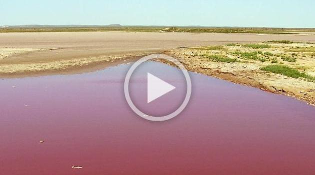
Heat Wave Causes Exploding Sidewalks And A Blood-Red Reservoir In Texas. Some of the stranger symptoms of America's record heat in an eye-opening story from ABC News: "Doomsayers are always on the lookout for signs of the Apocalypse, and few have been more captivating than record-setting temperatures scorching the nation these days. Oklahoma City and Washington D.C., had the warmest July on record. This week, temperatures felt as high as 115 in 18 states, including Georgia, Iowa and Florida. Today, after 33 straight days of triple-digit temperatures, Dallas blisters at 108. With the elevated temperatures has come even more compelling fodder for the students of prophesy, including a reservoir stained blood-red in Texas, exploding sidewalks in Iowa, snail-slow railroad trains in the Midwest and ant infestations in Florida."
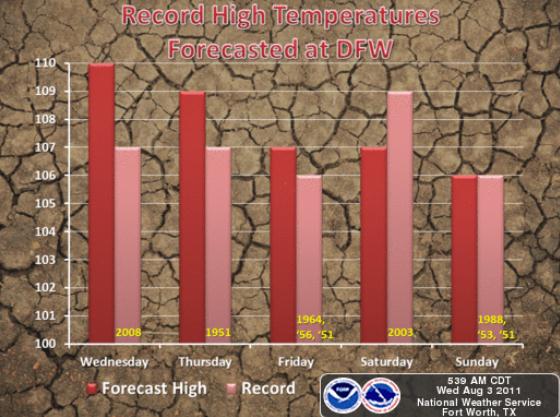
"Record breaking temperatures over 105 degrees are forecast at DFW International Airport this week and weekend. This will be some of the hottest temperatures we have seen in over a decade. An excessive heat warning remains in effect for much of North Texas."
Texas Agency Declares Electric Emergency Amidst Heat. Reuters has an update on possible brown-outs, triggered by nearly 5 straight weeks of 100+ heat across Texas: "HOUSTON, Aug 3 (Reuters) - The Texas power grid agency initiated an electric emergency on Wednesday for the second day in a row as all available power supplies were being used to meet soaring demand during an unrelenting heatwave across the state. No rolling outages were reported but the grid operator warned that power to some industrial customers might be curtailed if demand continues to climb. Power demand in the hour ending at 2 p.m. (1900 GMT) was 64,559 megawatts, 85 megawatts above the same hour a day earlier when the state set an all-time power consumption record of 67,929 MW at 5 p.m. "We expect to hit another all-time peak demand record today, so we are asking consumers and businesses to reduce their electricity use during peak electricity hours from 3 to 7 p.m.," said Kent Saathoff, vice president of system planning and operations for the Electric Reliability Council of Texas (ERCOT)."
NATIONAL WEATHER SERVICE LITTLE ROCK AR
325 PM CDT WED AUG 3 2011
...ALL-TIME HOTTEST TEMPERATURE EVER RECORDED IN LITTLE ROCK...
AT 240 PM CDT...THE TEMPERATURE AT ADAMS FIELD IN LITTLE ROCK REACHED 114 DEGREES...SETTING A NEW RECORD FOR THE ALL-TIME HOTTEST TEMPERATURE EVER RECORDED IN THE CITY. THE PREVIOUS RECORD WAS 112 DEGREES ON JULY 31ST 1986.
THE READING OF 114 EASILY BROKE THE RECORD FOR AUGUST 3RD. THE PREVIOUS RECORD WAS 107 IN 2010.

Helping Your Pets Keep Their Cool. Pets feel the heat as much as we do. If you're uncomfortable, chances are your pet is too. During the hottest time of the day keep your dog or pet indoors, make sure their dish is full of cool water, and be on the lookout for symptoms of heat stress. The Nebraska Humane Society has some great reminders in this YouTube clip: "Keep your pet safe in the summer heat by following a few simple warm weather pet tips."

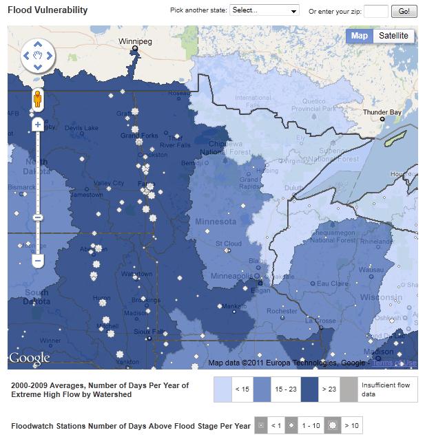
- July 2011 precipitation totals were highly variable. Some areas, especially in central Minnesota, reported eight to ten inches of rain for the month. In those areas, July precipitation totals more than doubled the historical normal. There were multiple days in July with torrential downpours that led to localized flooding. By contrast, July rainfall totals in northeast Minnesota were less than three inches, falling short of normal by one to two inches.
- When compared with April through July rainfall totals of the past, 2011 seasonal rainfall ranks above the 90th percentile in many southwestern, central, and northwestern Minnesota communities.
- Stream discharge values remain very high in nearly every major Minnesota watershed.
- The U. S. Drought Monitor depicts Houston County as "Abnormally Dry". No other drought areas were identified in Minnesota at the end of July. Northern St. Louis and Lake counties will be designated as "Abnormally Dry" in the next release of the product.
- Monthly mean temperatures for July 2011 were well above average across Minnesota. Preliminary data indicate that July 2011 will rank among the ten warmest Julys in Minnesota's modern record. The month of July was notable for the intensity, geographic extent, and duration of high dew point temperatures.
- The Colorado State University hurricane forecast team today maintained its earlier seasonal hurricane forecasts for the Atlantic basin in the 2011 season.
- 16 named storms.
- 9 of those named storms to be hurricanes.
- 5 of those hurricanes to be major hurricanes (Category 3 or higher).
- For the remainder of the season, they have also calculated probabilities for a major hurricane making landfall on the U.S. coast:
- A 70 percent chance that a major hurricane will make landfall on the U.S. coastline (full-season average for the last century is 52 percent)
- A 46 percent chance for the East Coast, including the Florida Peninsula (full-season average for the last century is 31 percent).
- A 45 percent chance for the Gulf Coast from the Florida Panhandle west to Brownsville (full-season average for the last century is 30 percent).
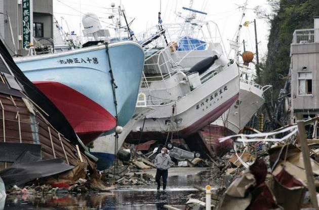
Photo credit above: Kimimasa Mayama/Bloomberg

A New Political Approach? Tired of the political extremes in Washington D.C.? Upset with the increasingly polarized Democrat vs. Republican agenda? You might want to check out the No Labels web site; they claim 100,000 members and growing rapidly. Their goal: to find bipartisan solutions somewhere in the common-sense middle, where most Americans probably see themselves right now. What is it going to take to reduce gridlock in Washington D.C. and make politics an honorable profession again? I don't pretend to know - but what I saw at nolabels.org seemed like a fresh, middle of the road, common-sense approach to me. We have to stop shouting at each other and find common ground, reinventing our country in the process. America 2.0: "Hyper-partisanship is one of the greatest domestic challenges our nation faces. It divides America and derails our ability to solve our shared challenges. Rather than focusing on solving problems, hyper-partisans use labels to demonize their opponents, enforce orthodoxy within their own ranks, and marginalize sensible compromises."
No Labels does not believe we need to search for better values or principles. The solution is even simpler: we must return to the essence of our beliefs. Most Americans in the vital center of our still great country believe that:
- Americans are entitled to a government and a political system that works – driven by shared purpose and common sense.
- Americans deserve a government that makes the necessary choices to rein in runaway deficits, secure Social Security and Medicare, and put our country on a viable, sound path going forward.Americans support a government that works to spur employment and economic opportunity by encouraging free and open markets, tempered by sensible regulation.
- Americans want a government that empowers people with the tools for success – from a world-class education to affordable healthcare – provided that it does so in a fiscally prudent way.
- America should be free from discrimination and should embrace the principle of equal opportunity.
- America must be strong and safe, ready and able to protect itself in a world of multiple dangers and uncertainties.

Television News: Are We Amusing Ourselves To Death? An Op-Ed at Huffington Post: "We've got the bubble-headed bleach-blonde who comes on at five. She can tell you about the plane crash with a gleam in her eye. It's interesting when people die. Give us dirty laundry." -- Don Henley, "Dirty Laundry." Anyone who relies exclusively on television/cable news hosts and political commentators for actual knowledge of the world today is making a serious mistake. Unfortunately, as Americans have devolved into non-readers with woefully short attention spans, newspapers providing even semi-analytical content have found themselves struggling to stay afloat while television, which delivers little more than news sound bites sandwiched between superficial chitchat and entertainment buzz, has become the prime source of so-called "news." In this way, real news of national significance is either underreported or unreported altogether, while contrived media spectacles such as the Casey Anthony trial are allowed to dominate the news headlines for days and weeks on end. As media theorist Neil Postman, author of Amusing Ourselves to Death: Public Discourse in the Age of Show Business, rightly observed, "The news of the day is a figment of our technological imagination. It is, quite precisely, a media event... Without a medium to create its form, the news of the day does not exist." (photo above courtesy of uselesshumor.com).

Bulletins From The Future. The Economist, possibly the best weekly news magazine on the planet, has a thorough report on how the Internet is reinventing (and personalizing) the news & information business, for better and worse: "The internet has turned the news industry upside down, making it more participatory, social, diverse and partisan—as it used to be before the arrival of the mass media, says Tom Standage. Even if you are not a news junkie, you will have noticed that your daily news has undergone a transformation. Television newscasts now include amateur videos, taken from video-sharing websites such as YouTube, covering events like the Arab spring or the Japanese tsunami. Such videos, with their shaky cameras and people’s unguarded reactions, have much greater immediacy than professional footage. Messages posted on Twitter, the microblogging service, have been woven into coverage of these events and many others. “You have these really intimate man-in-the-street accounts, and you can craft a narrative around them,” says Jack Dorsey, co-founder of Twitter. A computer consultant in Pakistan unwittingly described the raid on Osama bin Laden’s compound in a series of tweets. The terrorist attacks in Mumbai in 2008, too, were reported on Twitter in real time by people who were there."


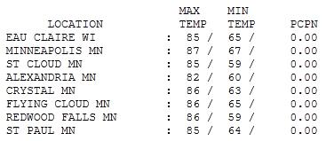
Nearly Perfect. I can't imagine a better stretch of weather in early August: dew points in the 50s, a light breeze, enough bright sun for highs ranging from 82 at Alexandria to 85 up in St. Cloud, 87 in the Twin Cities.

Paul's Conservation Minnesota Outlook for the Twin Cities and all of Minnesota:
TODAY: Plenty of sun, still quite comfortable. Dew point: 64. Winds: South 8-13. High: 84
THURSDAY NIGHT: Clear to partly cloudy (slight chance of seeing the Northern Lights?) Low: 65
FRIDAY: Partly sunny, sticky. Dew point: 70. Winds: S 10+ High: 86
SATURDAY: Muggy and unsettled, few T-storms likely. Dew point: 72. Winds: S 15-20. Low: 69. High: 87
SUNDAY: Sunnier, less humid, the nicer day of the weekend. Dew point: 61. Winds: NW 10-15. Low: 64. High: 82
MONDAY: Intervals of sun, still comfortable. Low: 63. HIgh: 81
TUESDAY: Chance of showers, thunder. Low: 66. High: 83
WEDNESDAY: Clearing, cooler breeze. Dew point: 57. Low: 64. High: 79

Weather Therapy
Maybe I should become an Atmospheric Therapist. I've spent as much time encouraging/reassuring people as I have handcuffed to the Doppler. "This too shall pass..we're 'gonna get through this!" No wonder so many of us suffer from perpetual weather angst; storm survivors enduring the meteorological equivalent of post traumatic stress disorder.
Jumbo droughts, searing heat, a 5 month flood on the Missouri River. Now comes word from SPC that 753 tornadoes touched down on America in April, nearly 3 TIMES the previous record! Dallas has gone 33 days/row above 100; it never cooled below 90 in Phoenix Tuesday night. Remarkable.
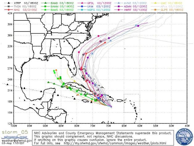
Tropical Storm Emily may brush the east coast of Florida with 60-80 mph winds by Saturday morning, an outside chance it could strengthen into a hurricane. Yes, our winters are cold, but at least our storms don't have names.
Dry weather hangs on into Friday as dew points creep up again - reaching 70 by Friday & Saturday. A few T-storms are likely Saturday, but skies clear Sunday with a welcome drop in humidity. Yep, Sunday should be a 5-star weather-day statewide.
No more 90s in sight; blast-furnace heat should remain well south of Minnesota. The worst is over.
Weather versus climate
No one weather event, including this heat wave, can be attributed directly to climate change, since climate is the sum of weather over time. Rather, climate change loads the dice, making it more likely that with any roll, you'll come up with extreme weather, including heat waves and heavy precipitation."
In Your Backard: New NRDC Web Tool Details How Climate Change Will Worsen Flood Rates And Other Problems Affecting Midwestern States. The story from PRNewswire.com: "Flooding can cause a range of health problems and risks, including: death and injury, contaminated drinking water, hazardous material spills, increased populations of disease-carrying insects and rodents, moldy houses, and community disruption and displacement. Many communities do not have plans in place to address these problems.
Among the other key findings throughout the United States:
- Another 41 percent of states (21: AL, AR, DC, GA, IL, IO, KS, KY, LA, MD, MI, MN, MS, MO, RI, TN, TX, VA, WA, WV, WI) had most of their watersheds with 15 or more days' extreme high flow - more than two weeks per year. Watersheds in every state experienced days of extreme high flows and/or multiple days above floodstage during the last decade.
- Of the 16 states most vulnerable to flooding, 81 percent do not have climate change adaptation plans that specifically address its health impacts (13 of 16: AK, CT, DE, IN, ME, MA, NE, NH, NJ, ND, OH, SD, VT), highlighting the low state of national climate-health preparedness in many location.
- On the positive side, 19 percent of states (3 of 16: FL, NY, PA) in the highest vulnerability group have flooding climate-preparedness plans to help protect their residents' health. Five other states have flood climate-health preparedness plans already in place (5 of 51, or 10 percent of states: CA, MD, OR, WA, WI)."
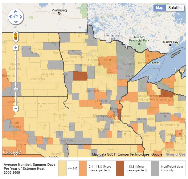
Minnesota's Changing Climate
- Average temperatures, rainfall, record floods, and extreme heat are all on the rise.1
- In the future, with climate change, average summer temperatures could rise by 12°F (7°C).2
- Residents will experience greater health risks from increasing dangerous heat waves, storms and flooding, waterborne illnesses, infectious diseases, declining air quality, and drought.
- Minnesota has a state climate change action plan, but it does not include a plan to prepare for the health impacts of climate change.

MINNESOTANS SHARE TESTIMONY ON SENSE OF PLACE
IN A CHANGING CLIMATE
Prominent Minnesotans, including former WCCO-TV anchor Don Shelby, polar explorer Will Steger and Science Policy Director for Fresh Energy, J. Drake Hamilton, will share their connection to Minnesota, how climate change is impacting their sense of place and daily lives, and what people can do about the issue at a free public forum moderated by MPR’s Kerri Miller, sponsored by the Will Steger Foundation.
Environmental stewardship and action begins with a local connection and sense of appreciation towards the natural environment. The event discusses the impacts of climate change on Minnesota’s natural resources and what citizens can do through the personal stories of prominent Minnesotans.
Minnesota is at risk from climate change. From the Boundary Waters Canoe Area Wilderness, to Lake Superior and the Mississippi River, water is a critical element of Minnesota’s rich ecological character. Minnesotans benefit from the many recreational, inspirational, and economic opportunities provided by this diversity of natural resources. It is precisely these ecological and natural resources that are at risk from climate change. With a focus on Minnesota’s natural resources, the forum takes place near the Mississippi River at the Town and Country Club in St. Paul.
Event is open to the general public and is part of the Will Steger Foundation's Summer Institute on Climate Change Education, which focuses specifically on Minnesota's changing climate.
Funding provided by Minnesota’s Environment and Natural Resources Trust Fund, as recommended by the Legislative-Citizen Commission on Minnesota Resources, National Park Foundation, National Park Service and Mississippi River Fund.
About the Will Steger Foundation:
Established by Polar Explorer Will Steger in 2006, the Will Steger Foundation is educating, inspiring and empowering people of all ages to engage in climate change solutions. www.willstegerfoundation.org.
Quick Facts
Event: Sense of Place in a Changing Climate (free public forum)
Date: August 11, 2011
Time: 7:30 PM
Place: Town and Country Club, 300 Mississippi River Boulevard North, St. Paul, MN
Call for more information: 612-278-7147
Web site: http://www.willstegerfoundation.org/component/k2/item/1260-free-public-forum

Here are a few of the findings (based on analysis of Gallup surveys of public opinion between 2000 and 2010);
- 14% of the general public doesn't worry about climate change at all, but among CWMs the percentage jumps to 39%.
- 32% of adults deny there is a scientific consensus on climate change, but 59% of CWMs deny what the overwhelming majority of the world's scientists have said.
- Three adults in 10 don't believe recent global temperature increases are primarily caused by human activity. Twice that many -- six CWMs out of every 10 -- feel that way."

Fox's Latest Assault On Climate Science: Attack SpongeBob. Yes, one of the stranger headlines I've come across lately. Here's an excerpt of the story at Huffington Post: "Today's (August 3) edition of Fox News' Fox & Friends included a remarkable exchange on the issue of SpongeBob Squarepants, climate change science, and the state of science education in the U.S. Apparently, using cartoons to teach children about important science issues of the day raises hackles at Fox, especially when those issues are at odds with their political perspectives. In particular, Fox & Friends attacked SpongeBob for an episode in which the role of human emissions (or at least SpongeBob and Mr. Krab's emissions) of carbon dioxide in global warming is made clear -- a scientific fact well understood for over a century. Fox's Steve Doocy acknowledges that the planet is warming; but doesn't understand why. He says "the big question is, 'is it manmade, or is it just one of those gigantic climatic phases that we're going through.'" A colleague says "It's unproven science." But for Gretchen Carlson, it isn't enough that the show tackled an issue of public concern, she just doesn't understand SpongeBob at all. She said "it's hard to even follow sometimes," while another commentator is heard saying "I don't get it."

No comments:
Post a Comment