MONDAY: Fading sun, late day shower or storm possible (some could be strong) - still a bit warm and sticky. High: 82
TUESDAY: A few clouds to start, otherwise a brighter, better day. Dew points falling into the 50s, feeling very comfy! Low: 61. High: 76
WEDNESDAY: Few clouds, low humidity, another beauty! Low: 58. High: 76
THURSDAY: Slight increase in humidity, but not bad - T-storms develop late afternoon across western MN and rumble across the rest of the state by evening/overnight. Low: 62. High: 80
FRIDAY: A little more humid with lingering showers and spotty thunder chances. Dew point: Low to mid 60s. Clearing overnight. Low: 65. High: 81
SATURDAY: Sunnier start, a few more clouds by the afternoon and a couple of spotty showers across the northern half of MN. Low: 65. High: 79
SUNDAY: Some sun to start with a few stray showers or storms developing by afternoon through central MN. Low: 62. High. 79.
Photo Courtesy Below: Lance Taylor and Spaceweather.com - you can see the full update HERE:
An intense storm on the sun has been hurling charged particles towards Earth over the past several days and folks at lower latitudes (as far south as Nebraska) have been treated to some crazy magnetic light shows.
The 2011 Aurora Gallery from www.spaceweather.com has some amazing shots from Minnesota too!

Video Time Lapse of the Aurora From South Dakota
Thanks to YouTube User - TheScoof for this video

The Storm on the Sun Strong Enough to Cause a Rare Radio Burst
This was the story from www.spaceweather.com:
NIGHT-TIME SOLAR RADIO BURST: The M9-class solar flare of August 4th produced a burst of shortwave static so powerful that receivers on Earth picked it up after sunset. "A RadioJove observer in Florida recorded the burst when the sun was 38 degrees below the horizon," reports amateur radio astronomer Thomas Ashcraft. Ashcraft's own radio telescope in New Mexico recorded the event 1 hour and 54 minutes after sunset:
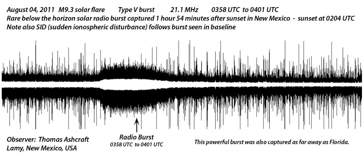
"To my knowledge, receptions like this are very rare," says Ashcraft.
Indeed they are. This event brings to mind the iconic night-time solar radio burst of March 8, 1958. Five radio telescopes at the University of Florida picked up emissions from the sun while observing the planet Jupiter in tthe middle of the night. On the other side of the world, radio astronomers in daylit Australia confirmed that a powerful solar radio burst had taken place at that exact time. The event is described in a 1959 Nature paper by pioneering radio astronomers Alex Smith and Tom Carr. They considered the possibility that solar radio waves might have been reflected by the Moon or carried to the night side of Earth by ionospheric ducting. In tthe end, they could not conclusively explain what happened and to this day night-time solar radio bursts remain a puzzle.
Indeed they are. This event brings to mind the iconic night-time solar radio burst of March 8, 1958. Five radio telescopes at the University of Florida picked up emissions from the sun while observing the planet Jupiter in tthe middle of the night. On the other side of the world, radio astronomers in daylit Australia confirmed that a powerful solar radio burst had taken place at that exact time. The event is described in a 1959 Nature paper by pioneering radio astronomers Alex Smith and Tom Carr. They considered the possibility that solar radio waves might have been reflected by the Moon or carried to the night side of Earth by ionospheric ducting. In tthe end, they could not conclusively explain what happened and to this day night-time solar radio bursts remain a puzzle.
There's Still A Chance to Catch Some of the Action
The Geophysical Institute from the University of Alaska Fairbanks still has an ACTIVE forecast for Monday.
Here is the Forecast: Auroral activity will be active. Weather permitting, active auroral displays will be visible overhead from Inuvik, Yellowknife, Rankin and Igaluit to Juneau, Edmonton, Winnipeg and Sept-Iles, and visible low on the horizon from Vancouver, Great Falls, Pierre, Madison, Lansing, Ottawa, Portland and St. Johns.

Still A Slightly Muggy Monday
A fast approaching cold front will move into the eastern Dakotas western Minnesota by late this afternoon/evening. Ahead of the front, somewhat soupy air (dew point values in the mid 60s) will help to trigger a late day storm potential (some could be strong/severe). The fast moving nature of the system will also help to limit the amount of time we will be plagued by inclement weather.. by Tuesday, a nice refreshing breeze from the northwest will draw in the much needed, cooler Canadian air mass that many have been waiting for this summer.
Simulated Radar Reflectivity for Monday Afternoon/Evening
The image below is a simulated radar reflectivity at 7pm - Keep in mind this is SIMULATED, but it depicts a line of storms trying to fire up along the fast moving cold front as it slides east. Note the northwesterly wind barbs showing up behind the front - that's when the cooler and less muggy air mass will start to move in!

Slight Risk of Severe Weather Monday
There is a SLIGHT chance that some of the storms that bubble up late this afternoon/evening along the cold front could be strong to severe. The Storm Prediction Center out of Norman, OK has parts of MN in a SLIGHT RISK area today.

Glancing Blows of The Real Hot and Humid Stuff
The real hot and humid weather will continue down south and at times, it will bubble north, but no where near the intensity that we had through July. The overall trend through the next week and a half is towards cooler and less muggy air. Any storm system that meanders our way from the west or northwest, will pull in that slightly more humid weather like we'll experience today. As the systems blow through, we'll get a taste of that cooler, Canadian, air that will feel just right at this point in the summer season (our last month of Meteorological Summer)
Temperatures A Few Thousand Feet Off The Ground Monday (Slightly Muggy Today)

Temperatures A Few Thousand Feet Off the Ground Next Week (Much Cooler & Less Humid)
By next week, the heat and humidity continues down south, while a puddle of much cooler air grows just north of the Great Lakes Region. We will likely be in the tug of war phase between these two air masses, at times cool and less muggy and at times warm and slightly muggy.

That's all for now. Thanks for checking in and have a good work week ahead.
- Todd Nelson
No comments:
Post a Comment