Slight severe threat today - watches and warnings are possible.
70-74 F. dew points possible by afternoon.
Half as much water in the air Wednesday as dew points drop into the 50s.
Paul's Conservation Minnesota Outlook for the Twin Cities and all of Minnesota:
TODAY: Heavy T-storms (AM hours). Some sticky midday sun, another round of strong/severe storms possible by afternoon. Dew point: 72 Winds: S/SW 10-20 (higher in T-storms). High: near 90
TUESDAY NIGHT: Evening T-storms, some strong, then clearing late. Low: 70
WEDNESDAY: Sunny, less humid: Dew point: 56. High: 83
THURSDAY: Sunny, beautiful start for the Minnesota State Fair! Dew point: 55. Low: 61. High: 82
FRIDAY: Few scattered T-storms. Sticky. Dew point: 63. Low: 66. High: 81
SATURDAY: Blue sky, low humidity, a bit cooler; probably the nicer day of the weekend. Dew point: 55. Low: 63. High: 78
SUNDAY: Fading sun, T-storms late? Dew point: 61. Low: 61. High: 76
MONDAY: Clearing, turning drier & cooler. Low: 60. High: 75

 135 mph winds: NHC's latest forecast for sustained winds in the eye-wall of Hurricane Irene before it comes ashore late this week (most likely landfall somewhere along the Carolinas coast). Map above courtesy of Ham Weather.
* Irene is moving slightly slower - it may still be just off the Carolina coast (packing 135 mph winds) by Day 5 (Saturday).
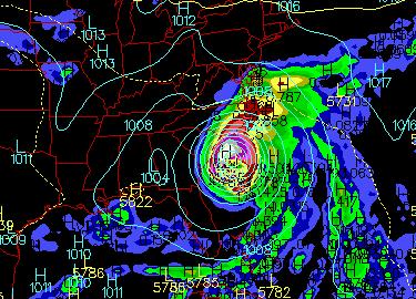
Landfall: Saturday? The exact timing (and intensity) is still very much up in the air, but "Irene" may slam into the coastal Carolinas as a major category 3 or 4 storm, fueled by unusually warm Gulf Stream water. GFS map above valid 1 pm Saturday.
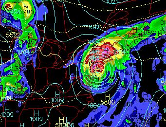
A (Weakened) Hurricane For New York City? The GFS model, valid Monday morning at 7 am, shows Irene very close to New York City, and it may still be a minimal hurricane. The reason? Much of the storm's circulation will remain over warm Gulf Stream waters, preventing the storm from weakening rapidly. This could be a worst-case scenario: a single hurricane capable of impacting 75-100 million Americans from the Carolinas, up the heavily populated eastern seaboard into New England. If this forecast pans out (not even close to a certainty at this point) Irene may be America's next billion dollar disaster.
51 days above 100 at Oklahoma City as of Monday afternoon. The old record for the most days/row above 100 was 50, set in 1980 (courtesy of Mark Vogan).
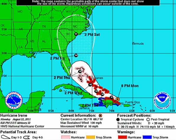
135 MPH Winds? Hurricane Watches are already posted for the Bahamas - I expect a Hurricane Watch to be issued for the east coast of Florida later today, possibly coastal Georgia and the Carolinas by tonight or first thing Wednesday. Here's Monday night's 11 pm discussion from NHC, which is now predicting Hurricane Irene to become a major category 3 storm with sustained winds close to 135 mph Thursday evening before weakening slight and coming ashore sometime Saturday - most likely between Savannah, Charleston and Wilmington, North Carolina.
HURRICANE IRENE DISCUSSION NUMBER  11
NWS NATIONAL HURRICANE CENTER MIAMI FL       AL092011
1100 PM AST MON AUG 22 2011

AFTER DEEPENING QUICKLY EARLIER THIS EVENING...THE INTENSITY OF
IRENE APPEARS TO HAVE LEVELED OFF A BIT OVER THE PAST HOUR OR TWO.
THE CENTRAL PRESSURE HAS DECREASED TO 980 MB ...AND MAXIMUM WINDS
HAVE NOT INCREASED SINCE THE EARLIER MAXIMUM OF 106 KT AT 850 MB.
THEREFORE...THE INTENSITY WILL REMAIN 85 KT FOR THIS ADVISORY.
OVERALL THE STRUCTURE OF THE CYCLONE HAS CONTINUED TO IMPROVE...
WITH A LARGE CDO FORMING NEAR AND NORTH OF THE CENTER AND THE
AIRCRAFT REPORTING A CLOSED EYEWALL.  SOUTHERLY SHEAR OF ABOUT 10
KT IS PRESENT OVER IRENE ACCORDING TO SATELLITE ANALYSIS FROM
UW-CIMSS AND THE SHIPS MODEL...BUT OTHERWISE THE ENVIRONMENT
APPEARS CONDUCIVE FOR CONTINUED STRENGTHENING.  THE NHC INTENSITY
FORECAST IS UNCHANGED FROM THE PREVIOUS SPECIAL ADVISORY AND SHOWS
IRENE BECOMING A MAJOR HURRICANE WITHIN 24 HOURS AND REACHING A
PEAK OF 115 KT IN 72 HOURS...FOLLOWED BY SLOW WEAKENING LATE IN THE
PERIOD.  THE NHC FORECAST IS HIGHER THAN MOST OF THE GUIDANCE
THROUGH 48 HOURS AND IS CLOSE TO A BLEND OF THE GFDL AND HWRF
MODELS AFTER THAT TIME.

AIRCRAFT FIXES INDICATE THAT THE CENTER WAS LOCATED A LITTLE TO THE
RIGHT OF THE PREVIOUS TRACK AND THAT THE FORWARD MOTION HAS SLOWED
A BIT...WITH AN INITIAL MOTION ESTIMATE OF 295/10. OVERALL THE
TRACK FORECAST SCENARIO HAS NOT CHANGED...AS IRENE WILL CONTINUE
MOVING WEST-NORTHWESTWARD FOR THE NEXT DAY OR SO ON THE SOUTHWEST
PERIPHERY OF A WEAKENING MID-LEVEL RIDGE. A MID- TO UPPER-LEVEL
TROUGH LOCATED EAST OF NORTH AMERICA WILL LIFT OUT WITHIN 24
HOURS...LEAVING A PRONOUNCED WEAKNESS IN THE RIDGE OVER THE
BAHAMAS.  THIS SHOULD ALLOW IRENE TO GRADUALLY TURN NORTHWESTWARD
AND NORTH-NORTHWESTWARD BY DAYS 2 AND 3.  AFTER THAT TIME...THE
TRACK OF IRENE APPEARS TO BE SENSITIVE TO THE TIMING AND AMPLITUDE
OF SEVERAL SHORTWAVE TROUGHS MOVING EASTWARD ACROSS THE UNITED
STATES/CANADIAN BORDER. THE MODELS ARE SHOWING SOME RUN-TO-RUN
VARIABILITY IN HOW MUCH THESE SHORTWAVES WILL AMPLIFY AND DEEPEN
THE MEAN TROUGH OVER THE NORTHEASTERN UNITED STATES...WHICH WILL BE
CRITICAL TO HOW SOON IRENE TURNS NORTHWARD OR EVEN EAST OF DUE
NORTH AT DAYS 4 AND 5. OVERALL...THE SPREAD OF THE GUIDANCE SUITE
HAS DECREASED THIS CYCLE...AND THE COMBINATION OF THE SLIGHT
RIGHTWARD ADJUSTMENT OF THE INITIAL POSITION AND A SLIGHT WESTWARD
SHIFT IN THE MODEL CONSENSUS RESULTS IN ONLY MINOR ADJUSTMENTS TO
THE NEW NHC TRACK FORECAST. THE BIGGEST CHANGE IS A SLOWER FORWARD
SPEED AT THE END OF THE PERIOD FOLLOWING THE BULK OF THE GUIDANCE
THAT KEEPS THE CYCLONE OFFSHORE AT DAY 5.

IT IS IMPORTANT TO REMIND USERS NOT TO FOCUS ON THE EXACT FORECAST
TRACK...ESPECIALLY AT DAYS 4 AND 5...SINCE THE MOST RECENT 5-YEAR
AVERAGE ERRORS AT THOSE FORECAST TIMES ARE 200 AND 250 MILES...
RESPECTIVELY.

OF NOTE...SYNOPTIC SURVEILLANCE FLIGHTS FROM THE NOAA G-IV AND AN
AIR FORCE RESERVE C-130 AIRCRAFT PROVIDED NUMEROUS DROPSONDES FOR
ASSIMILATION INTO THE 0000 UTC MODEL CYCLE.  THIS SHOULD IMPROVE
THE ANALYSIS OF THE ENVIRONMENT AROUND AND UPSTREAM OF IRENE.


FORECAST POSITIONS AND MAX WINDS

INIT  23/0300Z 19.9N  69.2W   85 KT 100 MPH
 12H  23/1200Z 20.4N  70.6W   95 KT 110 MPH
 24H  24/0000Z 21.1N  72.4W  105 KT 120 MPH
 36H  24/1200Z 22.2N  74.2W  110 KT 125 MPH
 48H  25/0000Z 23.5N  75.6W  110 KT 125 MPH
 72H  26/0000Z 26.5N  78.0W  115 KT 135 MPH
 96H  27/0000Z 30.0N  79.0W  105 KT 120 MPH
120H  28/0000Z 33.5N  78.5W  100 KT 115 MPH
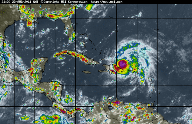
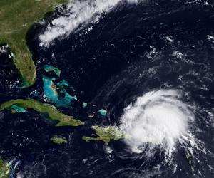
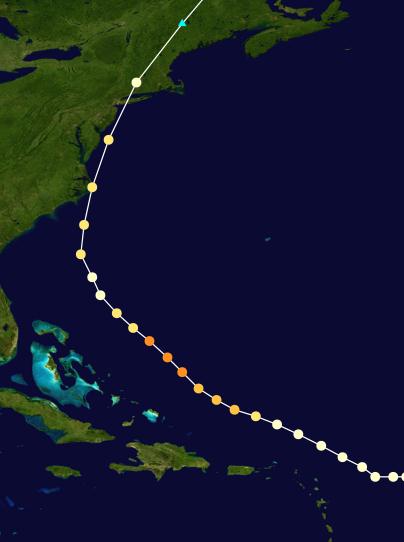
Hurricane Irene. As of late Tuesday night Irene had strengthened into a category 2 hurricane, with sustained winds of 100 mph, the core of the storm staying over water, passing just north of Hispaniola. Enhanced IR satellite loop courtesy of WSI's intellicast.com.
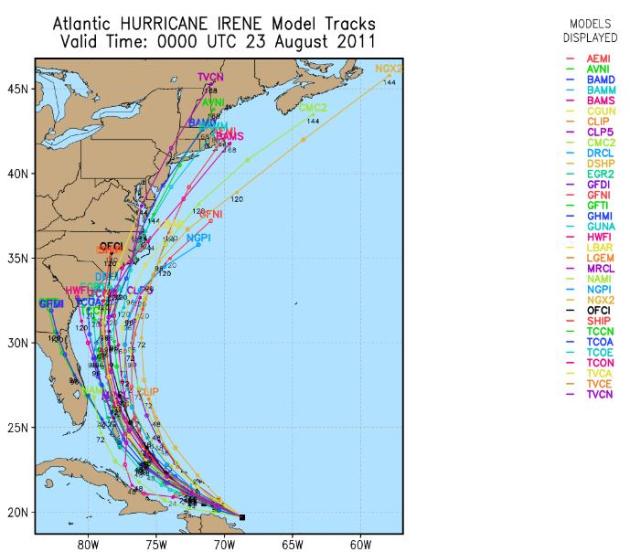
Hurricane Irene: Projected Track. There is fairly good agreement among the dozens of weather models out thru 72 hours - a direct strike is most likely along the Carolina coast, but eastern Florida is hardly out of the woods just yet. Models do a better job with the track than with intensity. According to NHC the accuracy for predicting landfall 4 days away is plus or minus 200 miles.
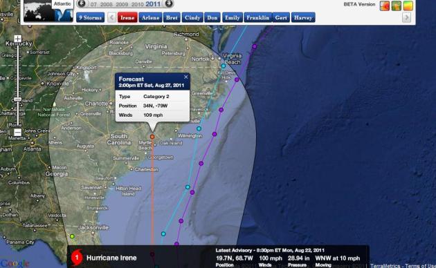
Landfall: More Likely Scenario. Althought the projected path has shifted slightly left (west) landfall is most likely along the Carolina coast, possibly Charleston or Myrtle Beach, possibly Hilton Head, with landfall now pushed back until sometime Saturday. The model above shows sustained winds close to 109 mph before landfall Saturday afternoon at 2 pm. Map courtesy of NHC and Ham Weather.
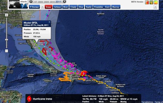
Landfall: Less Likely Scenario. The GFDL track has been consistently farther west (and more intense). The model is predicting 150 mph winds near Miami by 2 am Friday morning. As unlikely as this scenario is - we can't rule it out altogether. Why?
1). Unusually warm Gulf Stream water: temperatures ranging from 85-88. The warmer the water, the greater the potential for rapid intensification.
2). Little or no wind shear: A ridge of high pressure above the Bahamas should ensure favorable conditions for rapid strengthening - any winds aloft can shred a hurricane's circulation and prevent it from becoming a major storm.
Hurricane Irene Puts Puerto Rick Into State Of Emergency. More details from CBC News in Canada: "Hurricane Irene cut power to more than a million people in Puerto Rico, downing trees and flooding streets, before heading out over warm ocean water Monday on a path that could take it to the U.S. mainland by the end of the week. There were no reports of deaths or major injuries, but Gov. Luis Fortuno declared a state of emergency and urged people to stay indoors to avoid downed power lines, flooded streets and other hazards. "This isn't the time to go out to find out what happened ... This is the time stay in your homes," Fortuno said at a news conference. Schools and many businesses in the U.S. island territory are closed as crews began assessing the damage. The governor said people should avoid going out because of the danger posed by fallen live power lines and other hazards. He says he doesn't yet know when power will be restored." (satellite image courtesy of NOAA).
Rainfall Amounts For Puerto Rico (courtesy of NOAA):
- (Sunday morning through Monday morning)
- 10.51” Naguabo
- 8.34” Luquillo
- 7.77” Las Piedras
- 7.41” Ceiba
- 5.78” Canovanas
More On Hurricane Irene. We use cutting-edge weather graphics from Baron Services in Huntsville (OMNI and Vipir). Here is a late Monday discussion about Irene from meteorologist Kevin Nugent at Baron Services - where he talks about the growing probability that Irene will grow into a major (category 3 plus) hurricane in the coming days.
Baron Tropical Weather Discussion
Issued: August 22nd, 2011
Time: 8:00pm (CDT)
Storm: Hurricane Irene
Storm Discussion:
"Hurricane Irene has rapidly strengthened this evening. Maximum sustained winds are now at 100 mph, a Category 2, as the storm slowly moves to the NW at 10mph away from Puerto Rico and Hispaniola. Radar data from Puerto Rico also show that the storm has become better organized. An eye feature, though on the edge of the radar, has become more distinct the past few hours . IR satellite continues to show a small central dense overcast with strong convection. The heaviest of the weather associated with Irene has remained just off the north coast of Hispaniola as surface obs have shown winds below tropical storm force the past few hours and the CDO has remained just north of the island. Hurricane Irene will to continue to strengthen for several reasons. As the storm continues moving away from Hispaniola less land interaction will occur. Sea surface temperatures ahead of Irene are very warm, generally in the mid to upper 80’s and in time the storm will pass over the very warm Gulf Stream. Irene will is in an area with almost no wind shear as evident by the good upper level outflow seen on satellite and will encounter very little wind shear for the next 5-7 days. Per water vapor imagery, there is no dry air anywhere near the storm or along the future path of the storm. All these factors, will lead to Irene being a dangerous major hurricane as it moves NW thru the Bahamas. Hurricane Irene will move to the NW for next few days then move to the North and eventually NNE. Tropical ridging to the northeast of Irene and a mid level trough expected to move across the Northeastern US late this week will be the main steering forces for Irene this week and weekend.
The new 18z BAMS track moves Irene NW thru the Bahamas tomorrow and Wednesday then northward just off the east coast of Florida on Thursday and Friday. This is almost exactly in line with the 12z BAMS solution. The BAMS track is slightly to the left of NHC’s official forecast, and is close to the European model and the 18z run of the HWRF model. BAMS model is also slightly to the left of the current spaghetti plots which keep the storm off the east coast of Florida, Georgia and the Carolinas. With the current track and position/influence of the anticipated approaching trough, it is more probable that the greatest threat will be landfall somewhere from the South Carolina to southern North Carolina coastal areas which could occur sometime late Saturday There is still much uncertainty (a wide margin of error) with Irene’s track past 72 hours with respect to the ridge weakening and the strength of the approaching trough. Even if Irene does stay east of Florida there will still be at least the effects of tropical storm force winds but more importantly, tidal surge(s)."

Hurricane Irene To Slam Into The Carolinas. Here's an update from meteorologist Alex Sosnowski at AccuWeather: "It appears Irene will take a more typical path into the Carolinas, perhaps as a major hurricane, by the first part of the weekend rather than plow into Florida as a minimal system late this week. Given the setup in the atmosphere as well as where hurricanes have traveled from similar starting points, negotiating the Antilles, Irene may take a path similar to Hurricane Bertha in 1996. People in the eastern part of the Carolinas, especially the coastal areas and barrier islands should begin making preparations for a possible hurricane landfall that brings 100-mph winds or greater, storm surge flooding, torrential rainfall and possible tornadoes."
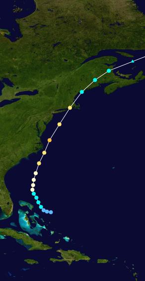
Hurricane Bob (1991) Hurricane Gloria (1985)
Comparing Irene With Similar Tracks. Wikipedia provides some perspective on what may happen with Hurricane Irene, on a potentially similar track with Bob (1991) and Gloria (1985):
Quick notes regarding Bob (Cat 3):
*Hurricane Bob was one the costliest hurricanes in New England history (approximately $2.42 billion in 2011 USD).
*17 fatalities.
*Coastal communities bore the brunt of the storm, with sustained winds between 83 to 107 mph.
*Peak wind gusts to 125 mph (201 km/h) were recorded on Cape Cod.
*Storm surge of 6 to 10 feet (Providence, RI was inundated).
*Rain totals: 3" - 7".
Quick notes for Gloria (Cat 4):
*East Coast damage: $1.84 billion in 2011 USD
*8 fatalities.
*Long Island experienced sustained winds of 90 to 100 mph with gusts up to 115 mph.
*Gloria Left 683,000 people in New York without power.
Severe Hail Storm In The Poconos. Check out this (2 hour!) YouTube video of a wild hail storm that hit Tobyhana, in the Poconos of Pennsylvania: "The hail continued for almost 2 hours. Up to golf ball size at times. Hail covering the ground was up to 2 inches in spots. Occurred on August 19, 2011."

Sony To Release 3-D, HD, Digital Binoculars. Good news for gadget freaks everywhere, although the price tag is pretty steep on this Christmas stocking stuffer. More details from gizmag.com: "Over the years Sony has shown its ability as a genuine innovator in the digital imaging space - in the early days of Gizmag the (then) bleeding-edge, 5-megapixel Sony F707 digital camera was a treasured part of our kit - and its latest venture looks like it could be holding that line. That venture is the company's move into digital binoculars with two models - the DEV-5 and DEV-3 - which boast full HD video recording, 7.1 megapixel still capture, optical image stabilization, 3D recording, HDMI output and (on the more expensive DEV-5) geotagging via an in-built GPS receiver."

Do You Remember Print Stories Better Than Those You Read Online? The short answer seems to be yes. Now what was the question again? Mashable.com has more details: "If a new research report is correct, you’re better off printing this story out and reading it if you want to remember it. A study by three doctoral candidates at the University of Oregon School of Journalism and Communication found that print news readers remember “significantly more” than those who read news stories online. Print readers also remember “significantly more” topics than online readers, the report found. Print readers and online readers recall headlines equally well. The three authors — Arthur Santana, Randall Livingstone and Yoon Cho — took a sample of 45 students. Of those, 25 read the paper edition of The New York Times and 20 read the newspaper exclusively online. The participants were asked to read each version of the paper for 20 minutes. Then they were quizzed on what they read."
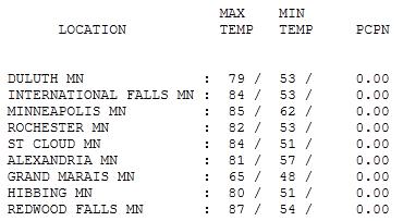
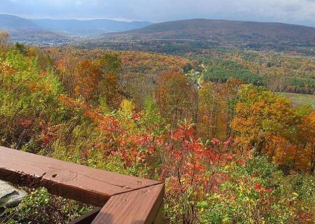
Wondrous Monday. What a day - low humidity, brilliant sunshine, a pleasant breeze, with highs mostly in the 80s. Poor Grand Marais - a breeze off chilly Lake Superior kept the "high" to only 65. Elsewhere highs ranged from 79 at Duluth to 84 in St. Cloud, 85 in the Twin Cities and 87 at Redwood Falls.

Best Time of the Year?
A subjective headline? Absolutely. Every season has its merits, but there's something extraordinary about late August. Severe storms are dwindling (at least in theory), fewer tropical downpours, less humidity, and a splash of fog some mornings as Mother Nature takes her foot off the gas. The kids are still home, the State Fair beckons, water temperatures peak, and the Twins AND Vikings are on the tube. Not bad.
A brief relapse of steamy, thundery weather returns today: near 90, sticky dew points (low 70s) with a slight severe risk, bringing back sweaty memories of mid July. Any discomfort will be fleeting, a cooler front returns Wednesday with a sunny, dry, lukewarm start for the State Fair Wednesday.
Meanwhile Florida is bracing for the first direct hurricane strike in nearly 2 years. "Irene" may strengthen into a major hurricane before coming ashore Thursday or Friday, anywhere from the Keys north to Jacksonville or Savannah. Water temperatures are warm (85-88 F), high-octane fuel capable of strengthening Irene into a major storm.
We get a lot of grief for living in Minnesota, but I can't imagine a Texas-size weather monster pinwheeling toward my house. It puts things into perspective.
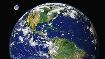
If Climate Change Isn't Happening, Why The Fight For The Arctic? Fast Company takes a look at the dramatic changes taking place in the Arctic - rapidly melting ice making it easier for the world's energy companies to drill for more oil and gas - a race to the top. Talk about a new "cold war" unfolding: "If you don't believe that the Arctic ice cap is melting, ask the Russians about it. In 2007, while many of us were busy arguing about whether or not climate change is real, a Russian mini-sub planted a titanium flag on the sea floor far beneath the floating ice lid, claiming the North Pole for the Motherland. Not surprisingly, that claim didn't go over well with the representatives of the United States, Canada, Norway, Sweden, Denmark, Finland, and Iceland, all of whom also have strong territorial interests--and military presences--in the Arctic. Until recently, nobody seemed to care much about who owned what up there among the polar bears, but things have changed. This summer saw the second largest meltback of sea ice on record. What was once considered a useless, frozen wasteland is now a booming frontier, and national tempers are heating up along with the local climate. One of the first signs of trouble was a spat between Canada and Denmark over Hans Island, a tiny bump of barren rock in the icy channel between Greenland and Ellesmere Island. Early surveys had left the rock's ownership quietly unresolved for years, but with all signs pointing to the opening of lucrative sea lanes between Europe and Asia, new deposits of fossil fuels and minerals, and future open-water fishing grounds, Hans Island suddenly mattered."
GOP Presidential Hopefuls Rush To Deny Climate Change. An excerpt from an article at The Australian: "In the past week, the Environmental Protection Agency has become the new target for Republican hopefuls, with conservative candidates scrambling to outdo each other over how quickly they would abolish it. The attacks have exposed a sharp split in the field between those who accept the scientific basis of climate change and those who do not. Michele Bachmann, the Tea Party insurgent, said that on the first day of her presidency, "the EPA will have the doors locked and lights turned off". Rick Perry, the Texas Governor and newest entrant in the field, slammed the agency for "job-killing over-regulation". In his book, Fed Up!, Mr Perry denounces the concept of man-made global warming as "one contrived phony mess that is falling apart under its own weight".

Climate Science Shouldn't Be "Religion" For Left Or Right. Climate science has been turned into a political football, on the left and right. Here is an article from The Atlantic that resonated with me: "I wish to associate myself with these remarks of Jonathan Adler's, so I hope he will forgive me for the extended excerpt: "Although Christie adopted the desired policy -- withdrawing from RGGI -- someconservativesareaghast that he would acknowledge a human contribution to global warming. According to one, this makes Christie "Part RINO. Part man. Only more RINO than man." ["RINO" as in "Republican in Name Only."] Those attacking Christie are suggesting there is only one politically acceptable position on climate science -- that one's ideological bona fides are to be determined by one's scientific beliefs, and not simply one's policy preferences. This is a problem on multiple levels. Among other things, it leads conservatives to embrace an anti-scientific know-nothingism whereby scientific claims are to be evaluated not by scientific evidence but their political implications. Thus climate science must be attacked because it provides a too ready justification for government regulation. This is the same reason some conservatives attack evolution -- they fear it undermines religious belief -- and it is just as wrong. Writing at MichelleMalkin.com, Doug Powers warns that "if some politicians think they can swim in the waters of AGW without getting wet or soaking taxpayers, they should think again." In other words, once you accept that human activity may be contributing to global warming, embracing costly and ill-advised regulatory measures is inevitable. Yet it is actually Powers, not Christie, who is embracing a dangerous premise. As Christie's veto shows, he understands that the threat of climate change doe snot justify any and all proposed policy responses. One can believe the threat is real, and still think cap-and-trade is a bad idea. Christie's critics, on the other hand, seem to accept that once it can be shown that human activity may be having potentially negative environmental effects, this alone justifies government intervention. Yet the environmental effects of human behavior are ubiquitous. Human civilization necessarily entails remaking the world around it. So if recognizing negative environmental effects leads inevitably to governmental intervention, there is virtually no end to what government needs to do, global warming or no."

No comments:
Post a Comment