63 mph wind gust early Tuesday in Buffalo from the severe storms that rumbled across the state around 5 am.
52-57 F. dew points predicted for today, nearly half as much water in the air than yesterday, when dew points topped 70.
30 mph wind gusts expected today, less wind on Thursday under a bright blue sky - a perfect start to the Minnesota State Fair.
Saturday: probably the sunnier, drier, nicer day of the weekend.
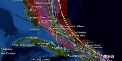
Hurricane Warnings posted for the Bahamas, a Hurricane Watch may be needed for the Carolinas by tonight.
"...This type of path brings with it dangers not often seen in the urban areas of the Mid-Atlantic and New England states. Cases of up to 10 inches of rain; winds steady at 55 mph and higher than 75 mph in gusts; and wave/surge/coastal flooding issues in the Delmarva, New Jersey, NYC/Long Island and Connecticut shorelines are increasingly likely." - analysis from meteorologist Larry Cosgrove.
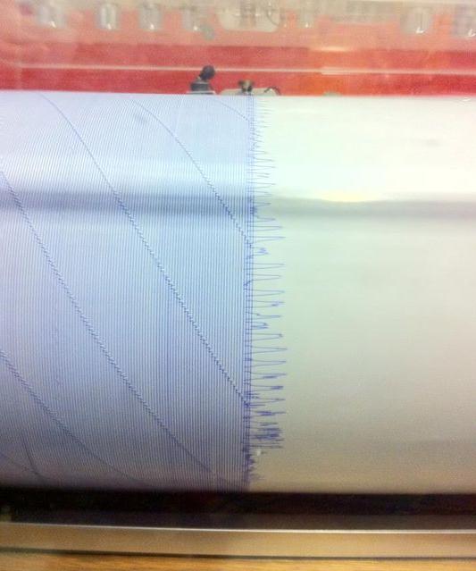
Worst East Coast Quake in 100 Years. Here is a seismograph print-out of the 5.9 quake that rattled windows from Toronto and Cape Cod southward to the Carolinas, centered near Richmond, Virginia. More from Facebook: "The recent 5.8 earthquake centered near Richmond registered on the seismometer here on campus at Cape Henry!"
* From a friend (meteorologist Keith Eichner) who lives in Rochester, New York! "...All my friends felt it in northeastern PA and DC and Richmon area. Here...no ground motion that I could detect. But at the time...I heard banging in my south wall of the house...sounded like a raccoon was in the wall thrashing around. It must have been the pipes...lasted 15 seconds, and I yelled downstairs to Barb..."are you pounding chicken or something?" She said, no! I realized what it was after we got a frantic phone call from Maryland..."turn on CNN, there was an earthquake here!" My friend in Poolesville MD said dishes were falling off of her kitchen shelves there. Again...no ground motion that I could detect outside of Rochester...Pittsford...but clanging noises in south wall of house."

Earthquake Damage In Baltimore. 4 words I never thought I'd see in a headline. This photo is from WBAL-TV's Chuck Cochran.
* 5.3 intensity earthquake in Colorado Tuesday, strongest tremor in 40 years.
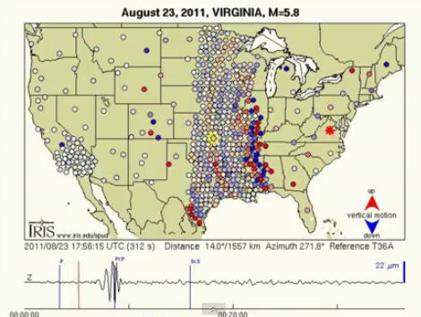
Virginia Quake Seismic Waves March Across The USA. Check out this amazing YouTube clip, explaining how earthquake waves radiate out across the nation, much like waves in an ocean: "Seismometers from the EarthScope project Transportable Array measured the up-and-down motion of the ground from the magnitude 5.9 earthquake that occurred in Virginia on August 23, 2011. You can see the waves move across the country! Red is upward motion; blue down. The height of the wave was only 22 microns!"
Original data: http://www.iris.edu/spud/gmv/109962
Credit: Data from the TA network were made freely available as part of the EarthScope USArray facility supported by the National Science Foundation, Major Research Facility program under Cooperative Agreement EAR-0350030
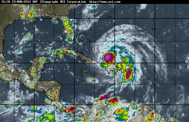
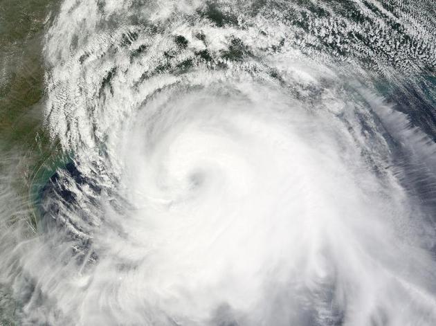
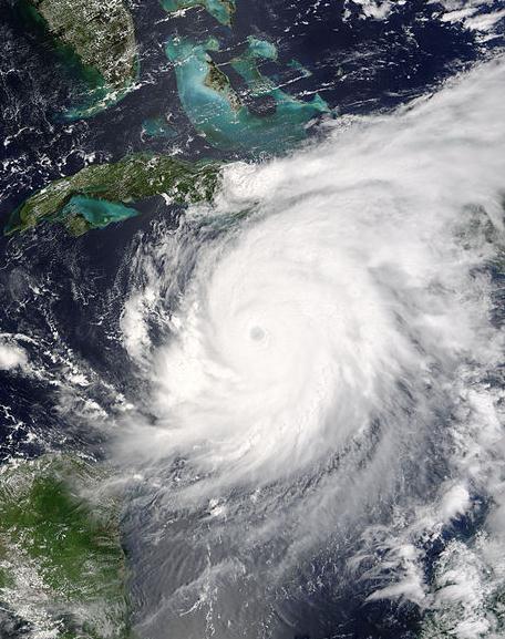
Irene: Developing An "Eye". The late Tuesday enhanced IR satellite loop shows Irene becoming more concentric/circular, gaining steam, now that it's pulling away from the Dominican Republic and Haiti, passing over warm, 86 degree water temperatures near the Turks and Caicos. Further strengthening is likely over the next 48 hours - Irene forecast to become a category 3 hurricane with sustained winds of 125+ by Friday. Loop courtesy of WSI's intellicast.com.
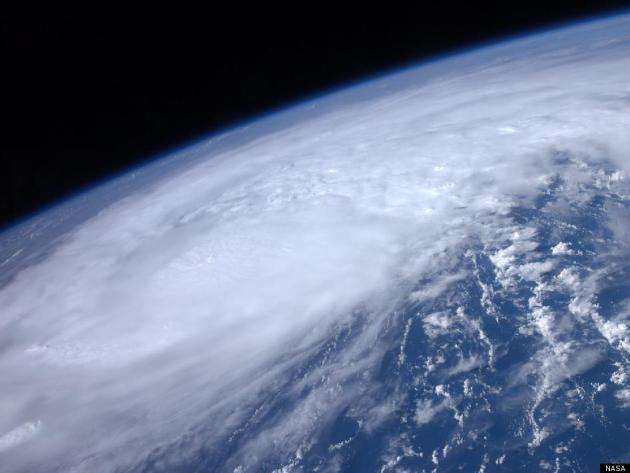
Irene From Space. Most satellite images are taken from the GOES, geostationary weather satellite, 22,300 miles above the equator. This image was snapped by the ISS, the International Space Station, on Tuesday - courtesy of NASA.
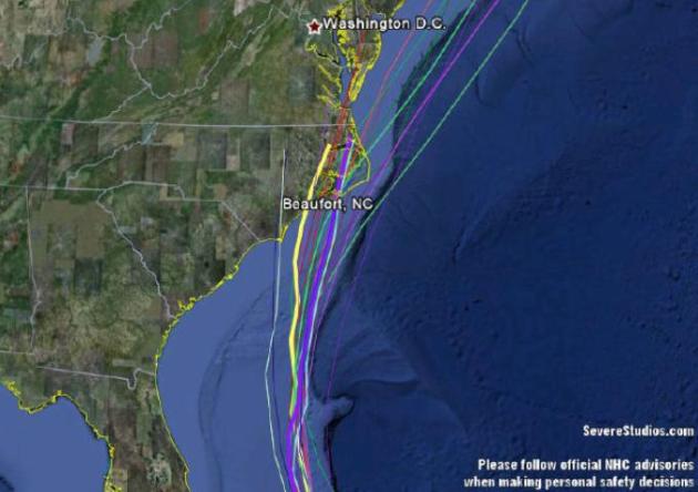
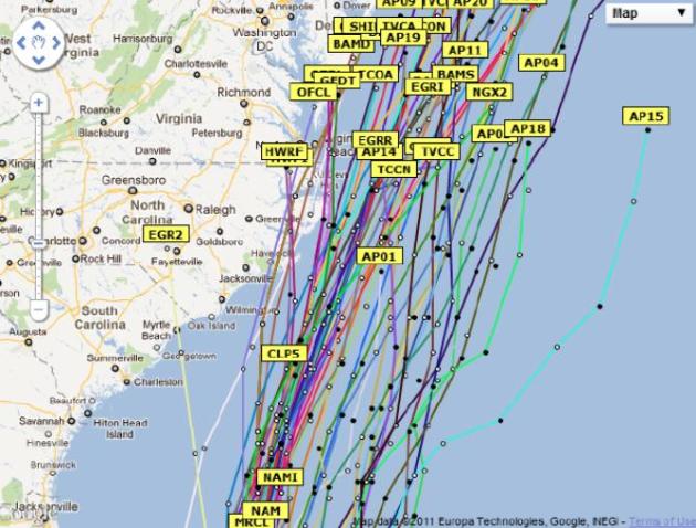
Narrowing The Solutions. From Severe Studios: "model forecasts for Irene, dumping the major outliers and highlighting those that have been most accurate."

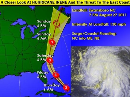
Will "Irene" Spare The Outer Banks Of North Carolina? It's still too early to say, but recent models seem to be nudging the track about 50-100 miles farther east, meaning the strongest winds and most extreme storm surge may pass just east of North Carolina Saturday. Details below.
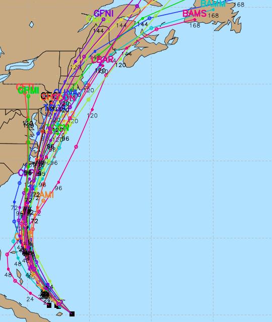
Latest Discussion From NHC (as of 11 pm Tuesday night):
IT IS FORTUNATE THAT WE HAVE A NOAA HIGH ALTITUDE JET SAMPLING THE
ENVIRONMENT OF IRENE AND TWO HURRICANE HUNTER AIRCRAFT...ONE FROM
NOAA AND THE OTHER FROM THE AIR FORCE...IN THE EYE OF THE HURRICANE
TONIGHT. THE SATELLITE PRESENTATION HAS IMPROVED WITH A RAGGED EYE
EMBEDDED IN DEEP CONVECTION AND A WELL ESTABLISHED OUTFLOW.  THIS
HAS RESULTED IN THE INCREASE OF BOTH OBJECTIVE AND SUBJECTIVE
T-NUMBERS. THE CENTRAL PRESSURE REPORTED FROM BOTH PLANES HAS COME
DOWN TO 969 MB AND THE MAX FLIGHT-LEVEL WIND MEASURED WAS 101
KNOTS. HOWEVER...DATA FROM THE SFMR INDICATE THAT THE SURFACE WINDS
HAVE NOT INCREASED YET AND THE INITIAL INTENSITY REMAINS AT 80
KNOTS.  IRENE WILL BE TRAVERSING VERY WARM WATERS AND ALTHOUGH THE
UPPER-LEVEL WINDS ARE NOT IDEAL FOR RAPID INTENSIFICATION...THE
OVERALL CONDITIONS FAVOR STRENGTHENING DURING THE NEXT DAY OR TWO
AS INDICATED IN THE PREVIOUS FORECAST...AND IRENE IS EXPECTED TO BE
A MAJOR HURRICANE AS IT MOVES OVER THE CENTRAL BAHAMAS IN ABOUT A
DAY.

SATELLITE AND RECONNAISSANCE FIXES INDICATE THAT IRENE IS STILL
MOVING TOWARD THE WEST-NORTHWEST AT A SLOW PACE OF 8 KNOTS. SINCE
THERE HAS BEEN NO CHANGE IN THE EXPECTED EVOLUTION OF THE STEERING
PATTERN...THERE IS NO REASON TO MODIFY THE PREVIOUS OFFICIAL
FORECAST WHICH BRINGS THE HURRICANE NORTHWESTWARD ACROSS THE
BAHAMAS...AND THEN NORTHWARD PARALLELING THE UNITED STATES
SOUTHEAST COAST AND VERY CLOSE TO OR OVER THE OUTER BANKS. IRENE
SHOULD CONTINUE NORTHWARD OR NORTH-NORTHEASTWARD ALONG THE MID
ATLANTIC COAST. THE TRACK GUIDANCE IS IN BETTER AGREEMENT TONIGHT
AND EVEN THE STUBBORN GFDL WHICH PREVIOUSLY INSISTED ON BRINGING
IRENE TOWARD FLORIDA HAS NOW SHIFTED EASTWARD AND HAS JOINED THE
OTHER DYNAMICAL MODELS. THIS INCREASES THE CONFIDENCE IN THE TRACK
FORECAST EVEN MORE.

USERS ARE REMINDED THAT LARGE FORECAST ERRORS ARE POSSIBLE AT THE
LONGER LEAD TIMES.


FORECAST POSITIONS AND MAX WINDS

INIT  24/0300Z 21.3N  72.4W   80 KT  90 MPH
 12H  24/1200Z 22.0N  73.5W   85 KT 100 MPH
 24H  25/0000Z 23.5N  75.0W   95 KT 110 MPH
 36H  25/1200Z 25.5N  76.5W  105 KT 120 MPH
 48H  26/0000Z 27.5N  77.0W  110 KT 125 MPH
 72H  27/0000Z 31.0N  77.0W  110 KT 125 MPH
 96H  28/0000Z 36.0N  76.0W  100 KT 115 MPH
120H  29/0000Z 40.5N  73.5W   75 KT  85 MPH
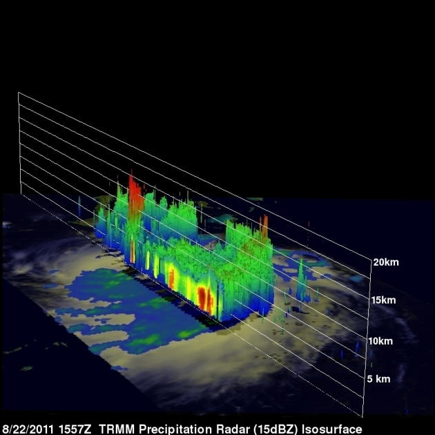
3-D Analysis Of "Irene". More details from NASA: "This 3-D perspective of Irene was created from TRMM satellite data taken at 15:57 UTC (11:57 a.m. EDT) on August 22, 2011. It revealed an area of deep convection (shown in red) near the storm's center where precipitation-sized particles are being carried aloft."
Credit: NASA/SSAI, Hal Pierce
NASA Satellites Measure A Large Hurricane Irene. From a NASA press release yesterday: "NASA satellites have been gathering data on Hurricane Irene as she heads the Bahamas today and tomorrow and observed that she is a large hurricane. Irene's hurricane force winds extend outward up to 50 miles (85 km) from the center and tropical storm force winds extend outward up to 205 miles (335 km). That means that Irene is about 410 miles in diameter. That's just shy of the distance from Washington, D.C. to Boston, Mass. NASA's Terra satellite captured an image of Hurricane Irene when the storm's center had passed Puerto Rico at 15:20 UTC (11:20 a.m. EDT) on August 22, 2011. The southern quadrant of Irene's clouds were still over the island bringing heavy rainfall. There is no eye visible in the image. The next day, the Geostationary Operational Environmental Satellite called GOES-13 saw Hurricane Irene approaching the Bahamas on August 23, 2011 at 1932 UTC (3:32 p.m. EDT). No eye was visible in the image, but the extent of Irene's large cloud cover is seen from eastern Cuba over Hispaniola. NOAA operates the GOES satellites, and the NASA GOES Project at NASA Goddard Space Flight Center, Greenbelt, Md. creates images and animations using that satellite data."
Potential For Two Landfalls From Irene? Landfall #1 possible Saturday, as Irene comes VERY close to the Outer Banks of North Carolina, probably close enough for a 5-10 foot storm surge, which may cut off some of the barrier islands from Duck, Corolla and Pine Island southward to Kitty Hawk. A second landfall can't be ruled out over southern New England late Sunday or Sunday night, with near-hurricane-force wind gusts lingering into Monday for the Boston area.
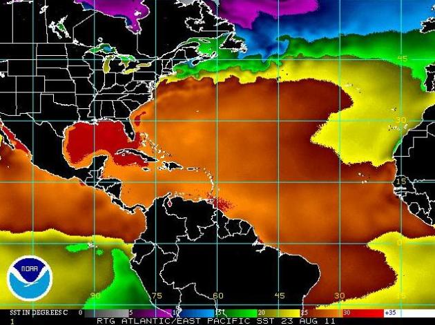
Sea Surface Temperatures. Warm ocean water fuels hurricanes - the warmer the water, the greater the potential for intensification. The latest SST map (courtesy of NOAA) shows water temperatures in the 80s as far north as the Mid Atlantic region - off the coast of Delaware and New Jersey, evidence of the Gulf Stream. The upshot? Hurricane Irene may retain its hurricane status as far north as New Jersey, possibly Long Island by Sunday.
Hurricane Ike: last major U.S. hurricane landfall (Texas, September 13, 2008). Ike hit Texas as a Category 2 storm, triggering nearly $30 billion in damage, claiming 112 lives in the U.S. More details on Ike here. (satellite image above courtesy of NASA).
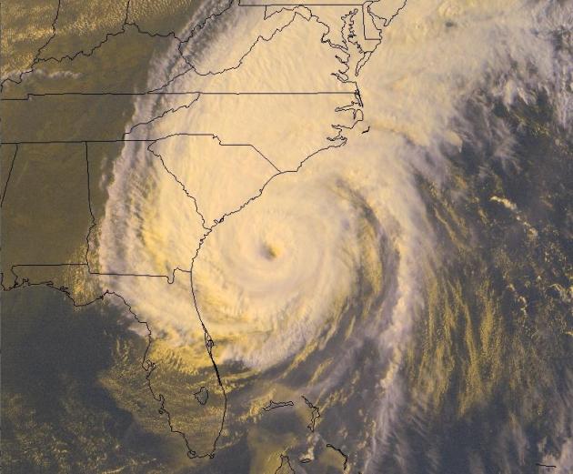
Hurricane Irene: On Track To Take Path Similar To Category 4 "Floyd" (1999)? Here are a few highlights from Hurricane Floyd, which hit the Carolinas very hard in 1999:
*Third largest evacuation in US history.
*Among the largest Atlantic hurricanes of its strength ever recorded.
*57 fatalities and $4.5 billion (1999 USD; $5.93 billion 2011 USD) in damage.
*At that time, the deadliest hurricane since Hurricane Agnes in 1972.
*Among the largest Atlantic hurricanes of its strength ever recorded.
*57 fatalities and $4.5 billion (1999 USD; $5.93 billion 2011 USD) in damage.
*At that time, the deadliest hurricane since Hurricane Agnes in 1972.
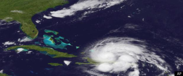
Hurricane Irene Marks First Big Hurricane To Hit U.S. In Years. Here's a good summary of Hurricane Irene, from the Huffington Post: "MIAMI -- The rapidly intensifying Irene that's already cut a destructive path through the Caribbean is the first hurricane to seriously threaten the U.S. in almost three years, a worry for some emergency management officials who hope people haven't become complacent about the dangers. The U.S. National Hurricane Center in Miami said Irene was likely to become a major Category 3 hurricane on Tuesday. By Thursday as it roars toward the U.S. coast over warm open waters, it could become a Category 4 with winds of 131 mph (210 kph) or more, NHC hurricane specialist John Cangialosi said late Monday. The last hurricane to make landfall in the U.S. was Ike, which pounded Texas in 2008."
A Significant Threat To the Northeast Corridor? Here is an excerpt from Houston Examiner meteorologist Larry Cosgrove, who knows his tropical meteorology: "There is now excellent consensus among the numerical models (both tropical and baroclinic) on the evolution, track, and intensity of Hurricane Irene. Irene as of this writing is approaching the Turks/Caicos chain, and has begun to acquire an eye while moving out of the disruption caused by the island of Hispaniola. Irene looks to move through the eastern third of the Bahamas before recurving northward, making a landfall along the NC coastline on Saturday evening. Since the circulation will have no real infringement from shear, dry air or cold water, it seems possible that Category 3 or 4 status will be attained by the time the hurricane approaches the U.S. But the big questions arise for the weekend, and how Irene may be characterized in terms of track and intensity. I blended the track scenarios and came up with the scenario of the hurricane moving fairly close to the coast, about 50 miles left of the shoreline. This type of path brings with it dangers not often seen in the urban areas of the Mid-Atlantic and New England states. Cases of up to 10 inches of rain; winds steady at 55 mph and higher than 75 mph in gusts; and wave/surge/coastal flooding issues in the Delmarva, New Jersey, NYC/Long Island and Connecticut shorelines are increasingly likely. We should have a more solid handle on the potential trajectory and strength of Irene by the afternoon hours of Wednesday August 24. But as of now, look for a very rough go of it east of the Appalachian Mountains all the way to the Atlantic coast above Wilmington NC.
Category 4 Storm Could Pass East Of Palm Beach County, Treasure Coast. Here's an update from the Palm Beach Post: "Irene's forecast path, while shifting away from South Florida, has grown in strength, and some forecasters are warning of a possible Category 4 storm as it passes to the east of Palm Beach County and the Treasure Coast. Irene could reach winds of up to 135 mph and bring tropical storm force winds to this area later this week, meteorologist Barry Baxter of the National Weather Service in Miami said Monday night. Irene intensified into a Category 2 hurricane Monday, the National Hurricane Center said. In its 11 p.m. Monday advisory, Irene had maximum sustained winds of 100 mph. The forecast track appeared to show the storm taking aim at the Bahamas and South Carolina, but Baxter cautioned that South Florida was still in the error cone."
Will North Carolina Be Spared? The latest trend from the models is to nudge the track of Irene farther east, out to sea. I suspect the Outer Banks will still see hurricane force winds and a significant storm surge by Saturday, but Irene's strongest winds (and most problematic storm surge) may pass just east of the Outer Banks. Data from NHC and yfrog.com.
Hurricane Irene Sends Reminder To Prepare For Possible Tornadoes. Here's a timely reminder of one of the other (potentially deadly) factors to consider in a hurricane: tornadoes spun up in the storm's outer, spiral bands. Captivasanibel.com has more details: "All eyes are on Hurricane Irene, and concerns about where that storm makes landfall may divert attention from other winds that blow as hurricanes approach. Hurricanes spawn tornadoes, and data seems to show that the tendency toward tornadoes has increased. According to the Insurance Information Institute (I.I.I.), tornadoes could form thousands of miles away from where a tropical storm hits. Hurricanes and tropical storms produce tornadoes because thunderstorms are embedded in rain bands that are far from the center of the hurricane, although tornadoes can also occur near the eyewall. Usually, tornadoes produced by a hurricane are relatively weak and short-lived, but they can still pose a threat. Almost all tropical cyclones making landfall in the U.S. spawn at least one tornado, according to the National Weather Service, and some spawn dozens of them. The largest known outbreak of tropical cyclone tornadoes was caused by Hurricane Ivan in 2004, with 127 tornadoes forming over a three-day period, according to data collected by The Tornado Project of the Universities Space Research Association. Eighteen of those tornadoes impacted Florida, and Ivan-caused tornadoes struck areas as far north as Virginia, Maryland and Pennsylvania." (satellite image of Hurricane Ivan above courtesy of NASA).
Army Corps Mississippi Flood Failures Demand New Vision. Here's an Op-Ed from James S. Russell at Bloomberg.com: "I stood at the edge of the Mississippi in New Orleans last May, the river so high that a fat wake would have sent swirling waters over the levee’s edge. That day the U.S. Army Corps of Engineers began opening the Morganza Spillway above Baton Rouge, Louisiana, routing water from the swollen Mississippi down the Atchafalaya River. To keep the Mississippi from overtopping levees in Baton Rouge and New Orleans, the diversion inundated farms and prime oyster-rich inlets. In Missouri, just two weeks earlier, the Corps had blown out more than two miles of levee at Birds Point to vent floodwaters that threatened Cairo, Illinois. A fifth of the river’s flow quickly covered 130,000 acres of farmland. The record-breaking spring floods “tested the limits of the system,” said Paul Harrison, senior director for Mississippi River and East Coast at the Environmental Defense Fund. He said the Army Corps, which has managed the river’s flow since 1824, “wants to continue to invest in the old system rather than look at these events as an opportunity to create a 21st-century system.”
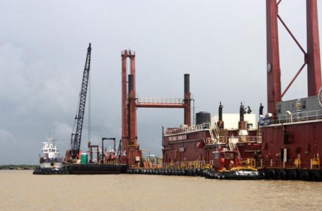
Photo credit above: "Dredging equipment near the mouth of the Mississippi River near Head of Passes, LA. The equipment must work constantly to maintain a navigation passage in the Lower Mississippi. Advocates of rebuilding receding coastal marshes would like to divert some of the flow to nurture expanding wetlands." (credit: James S. Russell/Bloomberg).

"Little House" Author Right On 1880's Winter. Yes, Laura Ingalls Wilder was an early climatologist of sorts, as described in this USA Today article: "Amid our summer's long heat wave, some cool comfort might come from Little House on the Prairie author Laura Ingalls Wilder's classic, The Long Winter. Blizzards and chills, after all, serve as the beloved childrens tale's backdrop, set against woeful winter weather that stretched from October to April, 1880-81. Best known from the series of books that inspired the Little House on the Prairietelevision shows which ran from 1974 to 1983, The Long Wintertells how Laura, her family, and the pioneer town of DeSmet, S.D., survived the winter, still a record-setter in many places across the Midwest — a story of tribulation and redemption. Now, one climate scientist reports that Wilder appears to have pretty much nailed the details of the blizzards even though she composed the story from memory with her daughter's help decades later."
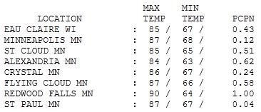
Tropical Tuesday. We got off to a noisy, windblown, thundery start - an early morning MCS system (meso-convective system) blew across central and southern Minnesota, whipping up 60 mph wind gusts and heavy rain. Amounts ranged from .12" in the Twin Cities to .51" at St. Cloud, an inch of rain at Redwood Falls. Highs ranged from 84 at Alexandria to 85 in St. Cloud, 87 in the Twin Cities and 90 at Redwood Falls.
Paul's Conservation Minnesota Outlook for the Twin Cities and all of Minnesota:
TODAY: Partly to mostly sunny, windy, less humid. Dew point: 54 Winds: NW 15-30. High: 81
WEDNESDAY NIGHT: Clear and very comfortable. Low: 55
THURSDAY: Nice fair weather! Less wind. Dew point: 55. High: 82
FRIDAY: Less sun, few T-storms possible. Dew point: 62. Low: 65. High: 81
SATURDAY: Nicer day of the weekend, plenty of sun, low humidity. Dew point: 57. Low: 66. High: 78
SUNDAY: Unsettled with a few T-storms, sticky. Dew point: 64. Low: 65. High: 79
MONDAY: Clearing trend, more comfortable. Low: 64. High: 79
TUESDAY: Plenty of sun, low humidity - feels like September. Low: 60. High: 75
Hurricane Irene
We get our fair share of storms in Minnesota, but nothing can compare with a hurricane. Imagine the most severe thunderstorm you've ever experienced. Multiply it by two, and have it last for 12-18 hours, accompanied by rapidly rising tides & swarms of tornadoes spun up by the hurricane's spiral bands.
Hurricane Irene may take a track similar to "Floyd" in 1999, which resulted in 57 deaths & $6 billion in damage. Because it's forecast to hug warm warm waters off the east coast, Irene may retain hurricane strength as far north as Cape Cod; a second landfall is possible over southern New England by Sunday PM. This hurricane may impact 75 million Americans, potentially the 10th "billion dollar" weather disaster of 2011, which would be a new record.
One advantage of Minnesota's lakes: they're much too cool (and small) to generate Texas-size storms like Irene.
Welcome to a gorgeous stretch of weather, which lingers into Day 1 of the Minnesota State Fair. Dew points drop into the 50s, more shades of mid-September. A few pop-up T-storms return Friday, again Sunday.
Saturday looks like the nicer day to wander the Minnesota State Fair in search of sweet (heart-healthy) treats!
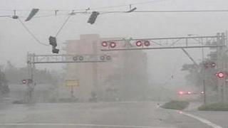
* photo above courtesy of WSVN-TV in Miami.
Climate Stories...

Huntsman, Romney Believe In Global Warming, But Not Action. Here's a story at the Washington Post: "Republican presidential candidate Jon Huntsman has been in the headlines lately for his outspoken belief in manmade global warming. All of a sudden, for at least one candidate, vocal environmentalism appears to be a strategic maneuver aimed at distinguishing himself from his rival Republicans. Huntsman isn’t alone among 2012 contenders or other prominent Republicans in affirming man’s involvement in climate change. Former Massachusetts governor Mitt Romney and New Jersey Gov. Chris Christie (R), and former House Speaker Newt Gingrich(Ga.) are right there with him. “They’re trying to appeal to moderates without angering the base. But it leaves you really exposed to the followup question — ‘What would you do?’” said Mike McKenna, a Republican strategist who works on energy issues. “I’m curious to see what Romney and Huntsman will do when that question comes up.”

Xcel CEO: Climate Change Science Is "Pretty Solid". Retiring CEO Dick Kelly is featured in a story at realaspen.com (taken largely from a recent Don Shelby interview at minnpost.com): “I’d be OK if there were never any more coal,” retiring Xcel Energy CEO Dick Kelly recently told the non-profit news site MinnPost.com. Kelly, who’s apparently moving from Minnesota (where Xcel is based) to Colorado (where Xcel is the state’s largest electric utility), went on to question those in Congress denying the science behind global climate change and the need to move away from fossil fuels. Counters MinnPost interviewer Don Shelby: “But, there are a lot of people in Congress who wouldn't agree.” That pretty much describes the four Republicans who make up Colorado’s GOP majority in the House. Kelly responds: “I know it. All they are worried about is the next two or six years when they run for reelection. They just keep kicking the can down the road.” Critics in Colorado, however, say Kelly has engaged in some pretty solid can-kicking of his own, investing heavily in coal and not proceeding as quickly on alternative fuels as he could have. “I think the science is pretty solid. Maybe we haven't communicated it well enough,” Kelly said. “But I think people do believe we need a change in the way we generate and use electricity. We've got to get off fossil fuels. The quicker the better.”

Climate Change Scientist Cleared In Closing Of U.S. Data-Altering Inquiry. Bloomberg has the details: "Michael Mann, a Pennsylvania researcher who’s been a target of climate-change skeptics, was cleared of wrongdoing by U.S. investigators in the flap surrounding e-mails hacked from a U.K. university. Finding no “evidence of research misconduct,” the Arlington, Virginia-based National Science Foundation closed its inquiry into Mann, according to an Aug. 15 report from the inspector general for the U.S. agency. Pennsylvania State University, where Mann is a professor of meteorology, exonerated him in February of suppressing or falsifying data, deleting e- mails and misusing privileged information. Climate-change doubters pointed to the stolen U.K. e-mails, which surfaced in blogs in 2009, as proof that researchers conspired to quash studies questioning the link between human activity and warming. Last week, Texas Governor Rick Perry, who is seeking the Republican nomination for president, renewed the assertion that scientists have “manipulated” data on climate change."
No comments:
Post a Comment