TODAY: Partly sunny. Slight chance of a stray shower or T-shower by evening. Dew point: 61 Winds: S 10-15. High: 80
TUESDAY NIGHT: Humid, a risk of a T-shower. Low: 62
WEDNESDAY: Turning drier & sunnier. Dew point: 60. High: 82
THURSDAY: Hot front, steamy. Dew point: 71. Low: 68. High: 96
FRIDAY: Storms likely, some heavy. Low: 72. High: 84
SATURDAY: Sunnier, less humid. Better day of the weekend? Low: 62. High: 76
SUNDAY: AM sun, PM instability showers possible. Low: 58. High: 73
MONDAY: Unsettled, PM shower or sprinkle. Low: 56. High: 71
Irene is now among the 30 deadliest hurricanes in U.S. history; damage cold top $12 billion. Source: Wall Street Journal.
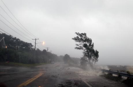
East Lake Road in Woodstown, New Jersey. Image source.
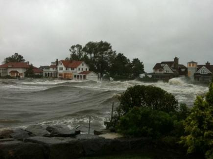
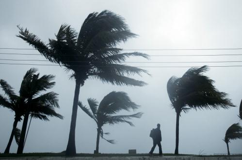
Greenwich, Connecticut. Image source.
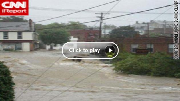
25 Frightening Photos Of Hurricane Irene's Destruction. Buzzfeed.com has a series of photos that tell the story better than any words ever could.
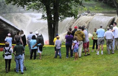
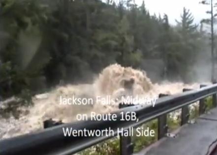
273 roads and bridges damaged in Vermont.
1927. Last year flooding in Vermont was this extensive.
Outer Banks of North Carolina: over 200 roads closed, 21 bridges impacted by Irene; 2,500 local residents cut off by storm surge. (CNN).
38 deaths in 11 states.
Billions of dollars in damage anticipated from Hurricane Irene.
65 major disasters so far this year across the USA where FEMA was activated to help with clean-up efforts (and funds).
Donate. Want to help survivors? Click here for a list of resources, courtesy of spotify.com.
"...The coverage became more a form of entertainment and less of a public resource, said Lise King, a fellow at Harvard University. "The two agendas cannot co-exist, as one serves to lead citizens into calm action and the other is meant, by nature, to drum up emotional responses in order to keep the viewer tuning in," she said." - AP article on Irene. Was coverage overblown? Experts speculate and pontificate below.
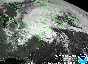
"...Usually, says Jeff Masters of Weather Underground, it’s difficult for hurricanes to keep their strength much past North Carolina because ocean temperatures plunge below the 79°F level that can generate those strong winds. Not this year: “Sea surface temperatures 1° to 3°F warmer than average extend along the East Coast from North Carolina to New York.” In fact, in all the years of record keeping, only one summer has had warmer water—last year."
"...We’ve just never had so much crazy weather all at once. Even before Irene, the U.S. had already set a record in 2011 for the most billion-dollar weather disasters. Recently, JFK airport marked its all-time rainfall record, on the same day that many Southwest cities set new records for most days above 100°. As carbon traps more heat in the atmosphere, it expresses itself in ever more violent weather. If you don’t believe the scientists, then ask the insurance industry. Munich Re, one of the world’s largest insurers, summed up its record payouts from the record-hot year of 2010: “This rise cannot be explained without global warming.” - from a Daily Beast article on Irene below.
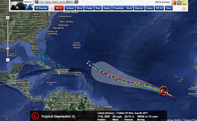
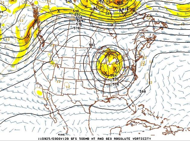
Soon-To-Be-Hurricane Katia? "Invest 12" is on the verge of becoming a tropical storm, closer to Africa than the Lesser Antilles, but forecast to become a Category 2 hurricane within 5 days. With any luck steering currents around a Bermuda High will steer the storm away from the east coast. The truth: it's way too early to know - but it wouldn't be a factor for the USA until next week. Map courtesy of NHC and Ham Weather.
"Some Hurricane", New Yorkers Grumble As Danger Passes. Was the storm over-hyped? That's open to debate, and the debate is ongoing. The fact that this hurricane was taking aim at the world's media center, New York City, may have been a big factor in the level of coverage (and the tone of that coverage). The New York Times reports: "On Saturday, when the word was that Hurricane Irene had New York City in its sights, Mike Fenton was proud of himself: “I bought the last loaf of bread on the West Side.” On Sunday, after the storm had delivered something less than a knockout punch to the city, his mood had changed. The two hours he had spent going to three grocery stores to find the bread? He really did not want to talk about it. “With all the preparations and all the hoopla on TV, it was all for naught,” he said. “I feel embarrassed that we made such a to-do.” The city government spent days turning complacent New Yorkers (if complacent is what they are) into worrywarts (if worrywarts are what they became). And then, reverting to type once the danger had blown by and left them alone, they said it was much ado about — maybe not nothing, but surprisingly little. A hurricane? It had been downgraded to a tropical storm by the time it hit Coney Island, they said with a certain Seinfeldian glee, for they knew they really had nothing to complain about." (photo credit here).

Irene's Impact (courtesy of Planalytics):
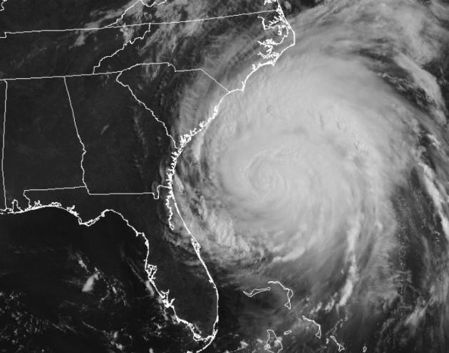
* Irene peaked as a Category 3 major hurricane and made its first U.S. landfall on Saturday as a Category 1 hurricane. In total, Irene impacted 17 states as well as several Canadian cities including Montreal and Halifax.
An estimated 80 million consumers were within 200 miles of the eye of the storm at some point over the past week.
* Irene made a second landfall at Little Egg Inlet, NJ on Sunday. It was the first hurricane to make landfall in the state since 1903.
* Irene caused over 4 million power outages, with many in the heavily populated northeast expected to be without power for up to two weeks.
* On the heels of a very wet August in the East (Philadelphia had its wettest month in history before Irene hit), the heavy, record-breaking rain up and down the East coast caused significant and widespread flooding and uprooted trees.
* An estimated 11,000 flights were cancelled, causing severe travel and commerce disruptions. Mass transit in all major cities was either slowed or stopped.
* Social media and smartphones played a significant communication role. This was not only true for individuals, but for businesses alike who provided valuable information and services to their communities, family, friends, and co-workers.
Vignettes From Irene's March Up The East Coast. The AP has a good overview of the impacts of Hurricane Irene, state by state: "VIRGINIA BEACH, Va. (AP) — In a hurricane that didn't fully deliver on its fearsome forecast for most areas, Casey and Denise Robinson's battered beach house is a terrible testament to the fickle nature of extreme weather. The Robinsons and a crew of friends arrived early Sunday to begin picking up the pieces of the storm-ravaged family getaway snuggled in the dunes of the Sandbridge section of Virginia Beach. A tornado spawned by Irene ripped the roof off their house and clawed through its contents, tossing insulation, shards of glass and splintered wood into trees, dunes and low-slung cactus. "This one's totaled," Casey Robinson said as he hastily gathered up boogie boards and other familiar remnants of the family beach house. "This is the only one on the beach that got hit this hard." The Robinsons went about their salvage work with unexpected cheer, reminiscing about the good times they had with their two children over the six or seven years they had owned the house. "This foosball table's ruined," Denise Robinson said. "We played a lot of tournaments on that." Casey Robinson, who said he and his wife and two teenage children were at their primary residence in Virginia Beach when the beach house was destroyed, summed up their sentiments with a shrug."
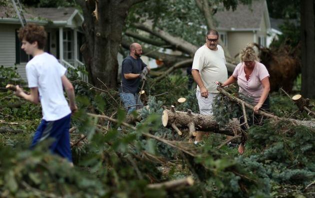
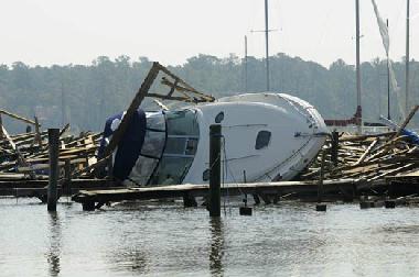
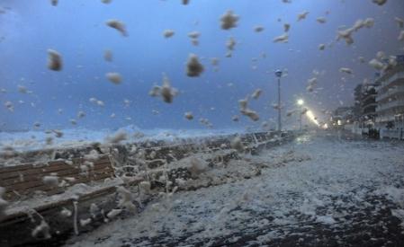
Photo credit: "A wave crashed over the tidal wall along the boardwalk Saturday as Hurricane Irene approached Ocean City, Md. (Ricky Carioti - Washington Post)"
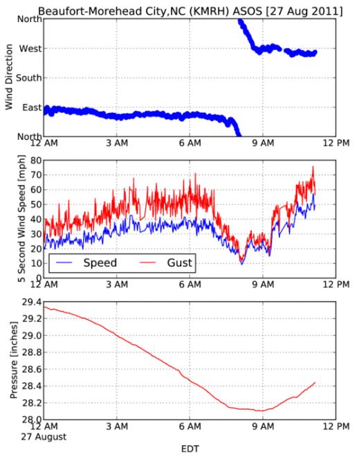
Anatomy Of A Hurricane. The Iowa Environmental Mesonet has raw data from Morehead City, North Carolina, showing wind direction, speed and barometric pressure. Details: "Hurricane Irene hit the east coast of the US this weekend bringing flooding rains and significant storm surge. The eye of the hurricane came ashore Saturday morning close to Morehead City, North Carolina. The featured chart is of one minute interval ASOS data from airport sensor in town. The one minute interval data was not available after about 11 AM local time. The traces nicely show the change of wind direction as the eye passes overhead along with the decrease in wind speed. This station was chosen for this plot as it had the lowest pressure reported among the automated sensors the IEM collects data from in the area."
Irene's Impact On Nuclear Reactors Out East: (thanks to James Aman from Earth Networks for passing this along).
- Most affected was Constellation Energy’s Calvert Cliffs Nuclear plant in Lusby MD - -
- 1 of 2 reactors automatically shut down, after flying debris shorted out a transformer in the electrical yard:
- Exelon Corp. (EXC)’s Oyster Creek plant near Toms River, New Jersey, was shut down as a precaution.
- Dominion’s two units at Millstone in southeast Connecticut were both reduced to 50% power.
* Photo credit: theresilientearth.com.
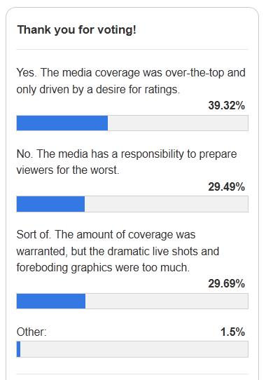
Poll: Was Hurricane Irene Over-Hyped? TV Newser has a poll, and here are the results (as of Monday afternoon). What do you think? "We kept you apprised of the many, many hours of extra news coverage that were added this weekend in preparation for Hurricane Irene — from the cable networks, to the broadcast networks, to the business networks, everyone was in overdrive. Now that the dust has settled — and Irene, by all accounts, was much less severe than expected — we want to know: was Hurricane Irene overhyped?"
Did Media Go Overboard Hyping Hurricane Irene? I still believe the fact that Irene was heading directly toward New York City (America's undisputed media capital) made a huge difference in the level and tone of coverage, but some of the storm surge predictions (up to a foot?) were wildly inflated - and probably resulted in a much larger evacuation than was ultimately necessary. In contrast the media probably underestimated the extent of inland flooding from tropical rains falling on saturated soil, from North Carolina to Vermont. THAT was the big story, not the 3-4 foot storm surge in New York Harbor. More from the AP: "NEW YORK (AP) — The clouds from Hurricane Irene had barely dissipated before a chorus of critics began suggesting that television networks had gone overboard hyping the storm before and during its march up the East Coast. For days, The Weather Channel and cable news networks reported on little else. Ultimately, they were affected by the unpredictability that is the nature of tropical storms. Irene largely spared New York City, where much of the media attention had been focused, while causing significant damage in places where it was unanticipated: Who planned for torrents of water in Brattleboro, Vt.? One media critic, Howard Kurtz, of The Daily Beast, called the coverage "a hurricane of hype." Manhattan resident Josh Hull, who left his downtown home to ride out the storm with friends on the Upper East Side, said broadcasters blew the storm way out of proportion. "I get that news is a business, but drumming up ratings at the expense of 28 million people is beyond the pale," Hull said. "My family, who all live in another part of the country, were worried sick all weekend while I slept right through the worst of it." The coverage became more a form of entertainment and less of a public resource, said Lise King, a fellow at Harvard University. "The two agendas cannot co-exist, as one serves to lead citizens into calm action and the other is meant, by nature, to drum up emotional responses in order to keep the viewer tuning in," she said. Media organizations defended their coverage, in some cases angrily. NBC News anchor Brian Williams recalled talking to a meteorologist from The Weather Channel on Wednesday night and said he had "never heard him so dire." Networks took cues from public officials, like when New York Mayor Michael Bloomberg ordered unprecedented evacuations and a full-scale public transportation shutdown in the nation's largest city."

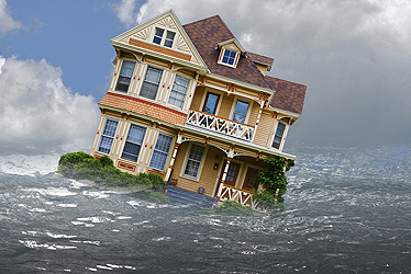
Don't Blame The Flood Insurance You Didn't Buy. The story from thestreet.com: "In places like southern Florida, where many areas are right at sea level or face special hazards from proximity to the shoreline or canals, the name of the game for homeowners is to avoid taking out flood insurance policies if possible. Those with mortgage loans fight a losing battle against loan servicers if they are in a FEMA-determined special flood hazard area. Those not facing pressure from loan servicers are obviously more concerned about the immediate cost than the potential consequences. All flood insurance policies are subsidized by the National Flood Insurance Program, or NFIP, since flood damage tends to be highly concentrated geographically, making it a challenge for an insurer to turn a profit. The NFIP also isn't cheap. The Government Accountability Office estimated in June that the NFIP still owed the U.S. Treasury $17.8 billion "to cover losses from the 2005 hurricanes." For a $200,000 home (estimated replacement cost) located in a special flood hazard area and "a foot below sea level," the annual premium is "somewhere around $700," according to premium estimates provided by Wayne Cox, of Cox Insurance in Fort Pierce, Fla." (photo credit).
Should The National Weather Service Be Scaled Back? Some thoughts on the proposed 30% cut to NOAA's budget from meteorologicalmusings.com: "During my 40 years as a meteorologist, I have a lot of experience with hurricanes and other major storms. I have observed that hurricanes tend to bring odd ideas to the surface. When you combine an earthquake, the odd ideas – if my email is any indication – really start flowing. Beyond the theories about airplane vapor trails and remote control of earthquakes, perhaps the oddest idea floating around now is that that the U.S. National Weather Service should be shut down or deeply scaled back. Saturday evening, a friend forwarded a Fox News op-ed calling for the NWS to be abolished. That op-ed, if you wish to read it, is here. It is easy to say, “abolish the National Weather Service.” Explaining why that is a bad idea is a bit more complicated, so I hope you will bear with me. The National Weather Service of the United States (NWS) plays a vital role that would be impossible for the private sector to fill. That is due to the unique nature of weather. Because weather does not respect national borders and because the weather moves around the world, all nations must cooperate in order for effective forecasts to be made. Private companies cannot legally conduct foreign policy; that is a role of the federal government. The federal government must create the essential international meteorological infrastructure and data sharing agreements."

Weather Channel Streaker. No, you can't make this stuff up. Huffington Post has the details: "Weather Channel reporter Eric Fisher was giving a live report about Hurricane Irene on Saturday when a streaker disrupted his coverage. Fisher said he was "pretty much speechless" about the swarms of people he saw reveling in the streets of Virginia Beach, even as Hurricane Irene whipped about all around him. Fisher clearly thought people were being foolish and reckless, but said he would "bite his tongue" to avoid being too frank about the situation. As if to prove his point, a group of young men in bathing suits ran past him during the live report he was giving, and one of them even flashed the camera--from behind and in front."

Don't Mock The Weatherguy - Or Else! Yes, forecasting weather, predicting storms, is a thankless task. People assume we know (or SHOULD know) more than we really do. We do the best we can with what we have. Here's an appropriate response from comedian Dean Obeidallah, as reported by CNN. The cries came from mainstream media, social media and even the unsocial streets of New York, where I live: "How can these guys call this a friggin' hurricane?!" Whenever the weathermen/women are the slightest bit off in their forecasts, they instantly became punching bags for the rest of us. People ask: How can the weathermen be wrong so often? Here is the simple answer: They are trying to predict the future! It's a forecast, meaning a prediction about an event yet to happen. And to make it more challenging, they are dealing with the weather, which to me, is a mystical, awe-inspiring creature. How can anyone know for certain what this supernatural beast will do? Yet these climate prognosticators, these weather gurus, these meteorologist psychics, if you will, are continually attacked for not predicting with pinpoint precision that, for example, 3 inches of snow, not 6, will fall from the mass of water droplets, known as clouds, positioned thousands of feet above us.

Steve Jobs Reigned In A Kingdom Of Altered Landscapes. How do you capture the genius of Steve Jobs? Dave Carr from the New York Times does a good job putting the magic into perspective, highlighting Jobs' ability to reinvent whole new business models: "Earlier this year, I wrote a column about the publishing industry’s resistance to the terms Apple was imposing for subscriptions on the iPad. Soon after, an e-mail was followed by a phone call and Steve Jobs was on the line to straighten me out. At the time, publishers were profoundly unhappy. Apple was not only proposing to take a third of the revenues, but it was also requiring that the transaction go through Apple, meaning publishers would get none of the consumer data that had such high value to advertisers. Mr. Jobs was friendly enough — I can recall a less pleasant conversation about the criminal case involving a stolen iPhone prototype — but he thought it was silly for publishers to whine about sales without data. After all, he said, they already did a tremendous business on the physical newsstand that did not provide a lick of data about their buyers."
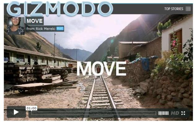
Traveling Around The World (in One Minute). Gizmodo has a pretty cool video on their site - a lifetime worth of global travel compressed into 60 seconds? "Rick, Tim and Andrew, three ordinary guys, decided to take a trip of a lifetime: 11 countries in 44 days. 18 flights and 38,000 miles later they have three 1-minute videos showing what life is like around the world. They recorded everything off two cameras and ended up with over a terabyte of footage which they cut, mixed and matched into an awesomely seamless blend of every notable place they've been. They broke down their trip into three parts: Move, which shows them walking around, Eat, which shows the delectable food they ate, and Learn, which shows all the amazing things they did. Three movies. One minute a pop. Watch them all. I dare you not to smile (and also dare you not to quit your job and blow all your savings on this type of trip)."
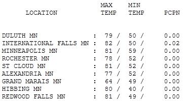
Good-Looking Monday. This is why I love late August and September: it's still warm, but humidity levels are lower, fewer wild T-storms, not nearly as much hideous heat. Days like yesterday. Highs ranged from 64 at Grand Marais to 81 at St. Cloud and the Twin Cities, 82 up at International Falls (yes, that's a bit odd).
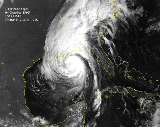
Sum Of All Fears
What's a meteorologist's worst nightmare? An EF-4 tornado heading toward a stadium or crowded shopping mall? Maybe a rerun of Hurricane Opal, with an even more terrifying outcome?
October, 1995: Opal is a Category 2 hurricane in the Gulf of Mexico. Floridians go to bed expecting a moderate hurricane; many fail to evacuate their coastal homes. Overnight, Opal mutates into a 150-mph monster, nearly Category 5 strength. Opal speeds up, veering toward Florida - NOT what the computers were predicting. Urgent warnings go out. Over 10,000 frantic motorists became stranded on the interstates, unable to move - sitting ducks. Many abandon their cars and set off, on foot, to higher ground. At the last moment Opal weakens & a catastrophe is narrowly avoided. But the storm's a huge wake-up call. Bottom line: Irene showed what a minimal Category 1 hurricane can do - inland flooding far worse than the coastal "storm surge". I sense a long hurricane season ahead.
A few T-showers are expected later today, conditions not ripe for anything severe. Models are hinting at a sudden "heat spike" on Thursday (90s - dew point near 70).
Friday storms give way to a cooler, drier front by Saturday.
Ignore Global Warming At Our Risk. Here's a timely Op-Ed from amarillo.com: "Last week, Hurricane Irene focused attention once again on climate change. Irene was only a Category 1 on the Saffir-Simpson Hurricane Scale, which rates storms by wind speed, but it carried a lot of water and dumped it on places that didn’t need it. Scientists in the field of atmospheric research tell us that storms are getting stronger, especially in the Atlantic, and that there is a direct correlation between the temperature of the ocean’s surface and the wind speed of the most powerful storms. For all Category 5 hurricanes the average increase in wind speed is 4.5 miles per hour per degree (Celsius) of increased ocean temperature. For the top ten percent of storms the increase in wind speed is 14.5 miles per hour per degree. Over the past 30 years the oceans’ tropical waters have warmed by half a degree Celsius. On one hand this doesn’t look like much. On the other hand, sustained warming means sustained increase in the power of the largest storms."

Shooting The Messenger. Here's an Op-Ed from the Miami Herald: "Texas Gov. Rick Perry stirred up controversy on the campaign trail recently when he dismissed the problem of climate change and accused scientists of basically making up the problem. As a born-and-bred Texan, it's especially disturbing to hear this now, when our state is getting absolutely hammered by heat and drought. I've got to wonder how any resident of Texas - and particularly the governor who not so long ago was asking us to pray for rain - can be so cavalier about climate change. As a climate scientist at Texas A&M University, I can also tell you from the data that the current heat wave and drought in Texas is so bad that calling it "extreme weather" does not do it justice. July was the single hottest month in the observational record, and the 12 months that ended in July were drier than any corresponding period in the record. I know that climate change does not cause any specific weather event. But I also know that humans have warmed the climate over the last century, and that this warming has almost certainly made the heat wave and drought more extreme than it would have otherwise been. I am not alone in these views. There are dozens of atmospheric scientists at Texas institutions like Rice, the University of Texas, and Texas A&M, and none of them dispute the mainstream scientific view of climate change. This is not surprising, since there are only a handful of atmospheric scientists in the entire world who dispute the essential facts - and their ranks are not increasing, as Gov. Perry claimed."


The Deniers of Global Warming Are Winning. Here's a blog post at seattlepi.com: "The House of Representatives voted 240-184 this spring to defeat a resolution that said that “climate change is occurring, is caused largely by human activities, and poses significant risks for public health and welfare.” The U.S. Chamber of Commerce informed the Environmental Protection Agency that “populations can acclimatize to warmer climates via a range of behavioral, physiological, and technological adaptations.” Secretary of State Hillary Clinton announced recently that melting of sea ice “will result in more shipping, fishing and tourism, and the possibility to develop newly accessible oil and gas reserves.”
Apparently these politicians know something that the scientists don’t?
The data of the past few years has shifted the paradigm for GW. What was forecast six years ago to happen in 2050 now is projected for 2020 (some of it is here in 2011).
Freak weather has become the norm: Deadly tornados in Joplin, Mo., and Tuscaloosa, Ala.; wildfires have engulfed large tracts in California, Oklahoma, New Mexico and Texas; severe droughts in the Southwest, parts of China and the Amazon; increased moisture in the air leading to huge snowpacks in some areas — which melt quickly in the summer; massive flooding along the Mississippi as well as in Australia, New Zealand, China and Pakistan; unprecedented heat waves in Russia, Eastern US, Europe and Asia; the fish stocks in the oceans are dying; the glaciers & polar ice caps are disappearing; etc. Not to mention the endless effects of steadily rising sea levels.
All of this is happening with only one degree of global warming. All numerical models that evaluate the effect of increased CO2 predict another degree warming is already in the pipeline, and several more degrees if CO2 continues to increase as it has the past decades. The fingerprints of fossil fuel burning are on the measured CO2.
No comments:
Post a Comment