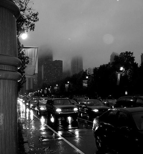
71 F. high in the Twin Cities Monday; Thursday may be 25 degrees warmer.
95 F high predicted for Thursday, dew point near 70.
Severe storms possible close to home Thursday night as a cooler front approaches.
49-54 F. dew points on tap for Saturday - half as much water in the air than Thursday.
64 days above 100 so far this summer season in Dallas/Fort Worth (record is 69 days, set in 1980)
23 consecutive days above 100 at Houston, Texas.
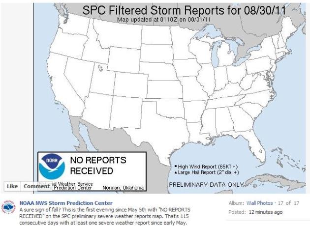
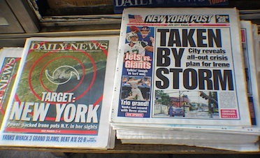
Signs of autumn....
Monday's Record Highs:
Austin Camp Mabry, TX 105
Midland, TX 105
Wichita Falls, OK 109
Tyler, TX 103
 Philadelphia's Record Summer:
July 2011 was Philadelphia’s hottest month on record. August 2011 is the rainiest month the city has ever had. Philadelphia on average receives 42.05 inches of rain throughout an entire year. Philadelphia broke a record for most rainfall at 13.61 inches and that was before Hurricane Irene. After the storm, new record breaking amount was 18.41 inches of rain in a single month.
Philadelphia's Record Summer:
July 2011 was Philadelphia’s hottest month on record. August 2011 is the rainiest month the city has ever had. Philadelphia on average receives 42.05 inches of rain throughout an entire year. Philadelphia broke a record for most rainfall at 13.61 inches and that was before Hurricane Irene. After the storm, new record breaking amount was 18.41 inches of rain in a single month.
* photo credit above: David Reilly,
flickr.
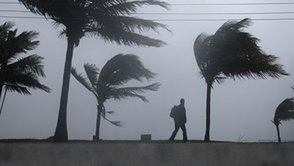
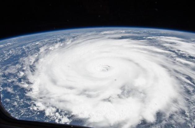
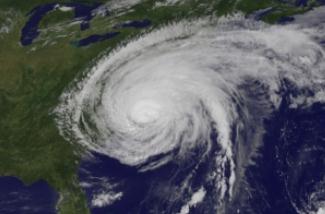
Tropical Storm Katia Strengthens, Expected To Become Hurricane. Americans are already hurricane-weary (and we've only had one direct strike, the first in roughly 3 years). With any luck steering currents will push Katia away from the east coast of the USA, but it may be a close call early next week. More from
Bloomberg News: "
Tropical Storm Katia may grow into a hurricane in the next two days as it moves west-northwest through the mid-Atlantic Ocean, according to the National Hurricane Center in Miami. The storm’s winds increased to 45 miles (72 kilometers) per hour from 40 mph earlier today as it churned across the Atlantic about 630 miles west-southwest of Cape Verde, according to a center advisory issued at about 11 a.m. New York time. “Continued gradual strengthening is forecast and Katia is expected to become a hurricane by late Wednesday or early Thursday,” the center said. Its current track and intensity forecasts have the storm growing into a Category 3 hurricane on the Saffir-Simpson five-step scale. Computer forecast models suggest Katia will turn into the Northern Atlantic, a maneuver meteorologists refer to as recurving. The move would mean Katia would miss the U.S., which was struck last weekend by Hurricane Irene, a storm that killed at least 40, cut power to 8 million homes and businesses and caused an estimated $2.6 billion in damage."
* It's early, but right now it appears that Hurricane Katia will make a turn to the north/northeast, avoiding the east coast of the USA early next week.
 Tropical Storm "Lee"?
 This is pure speculation - but an area of disturbed weather entering the Gulf of Mexico may strengthen to tropical storm status, even a hurricane, as early as Sunday. Right now the GFS brings this storm into coastal Alabama or the panhandle of Florida - but it's way to early to get specific.
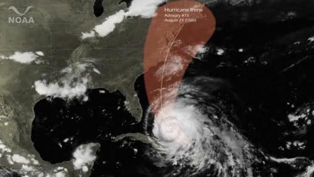
NOAA Accurately Predicted Irene's Path 4 Days In Advance. There's no question in my mind: NOAA's NHC branch nailed the track of Hurricane Irene. Here's a press release from
NOAA: "
Four days before Hurricane Irene struck eastern North Carolina and tracked northward, NOAA's National Hurricane Center accurately projected the storm's path. Even before then, forecasts showed that Irene would threaten the East Coast. This satellite animation shows Irene's progress across the western Atlantic and how it followed the National Hurricane Center's track issued at 11pm ET on Tuesday, August 23 (Advisory # 15)."
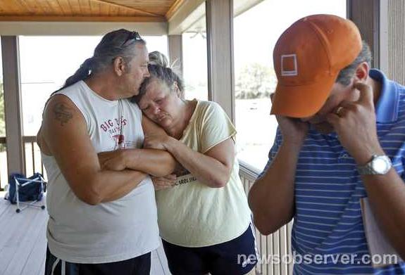
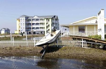
Irene Destroys 1,100 Homes In North Carolina. The grim details from the
newsobserver.com: "
Hurricane Irene destroyed more than 1,100 homes in North Carolina, causing damages that are estimated above $70 million and will rise higher as crop losses, clean-up costs and other expenses are added, Gov. Bev Perdue said today. But most beaches will be open for the Labor Day weekend, Perdue said at a news conference in Manteo. “Three-hundred-plus miles of our coastline is now open for business,” Perdue said. “Many of our beaches are open and will continue to open for the holiday week and weekend, and we urge folks to come to North Carolina.” Irene caused at least six storm-related deaths in the state and cut power to hundreds of thousands of North Carolina customers. Much of that power has been restored now. The latest county-by-county update from NCDOT shows that most roads closed by Hurricane Irene have reopened, but N.C. 12 and other roads in Dare County still face major problems."
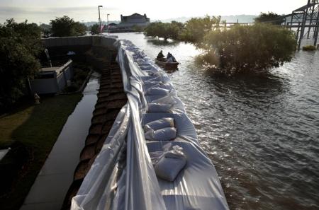
Vermont Towns Battle Historic Floods From Irene As Death Toll Tops 40. Here's a good overview on the flooding in Vermont (worst since 1927) from AP and
The Huffington Post: "
MONTPELIER, Vt. — The full measure of Hurricane Irene's fury came into focus Monday as the death toll jumped to 40, New England towns battled epic floods and millions faced the dispiriting prospect of several days without electricity. From North Carolina to Maine, communities cleaned up and took stock of the uneven and hard-to-predict costs of a storm that spared the nation's biggest city a nightmare scenario, only to deliver a historic wallop to towns well inland. In New York City, where people had braced for a disaster-movie scene of water swirling around skyscrapers, the subways and buses were up and running again in time for the Monday morning commute. And to the surprise of many New Yorkers, things went pretty smoothly. But in New England, landlocked Vermont contended with what its governor called the worst flooding in a century. Streams also raged out of control in upstate New York. In many cases, the moment of maximum danger arrived well after the storm had passed, as rainwater made its way into rivers and streams and turned them into torrents. Irene dumped up to 11 inches of rain on Vermont and more than 13 in parts of New York."
 Irene: "1 In 500 Year Flood":
Hurricane Irene
caused many rivers and creeks in upstate New York to crest at near record levels, leading to severe flooding in several communities.
The Mohawk River near Schenectady was expected to crest at a record 12 feet above flood level, promising what officials called a "500-year flood."
State officials were keeping a close eye on dams, and encouraged residents near the overflowing Pepacton Reservoir in Delaware County to leave the area.
* information courtesy of the New York Daily News. (photo courtesy of NASA).
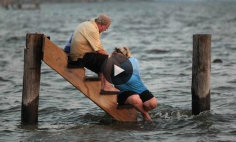
 Hurricane Irene Aftermath:
- At least 41 deaths across 11 states blamed on Irene so far. (updated 8/30 2:55pm)
- A total of 2.85 million customers still are without power (updated 8/30 2:55pm)
- In New Jersey, search and rescue teams have plucked nearly 600 people from
homes in recent days with the most intense efforts on Tuesday
when the Passaic River measured 13 feet (4 metres) above flood
stage (we have youtube video of this)
- More than a dozen towns in New York and Upstate New York are cut off because roads and bridges are washed out
- 400 hundred people are stranded at Killington Ski Resort in Vermont
- Vermont began mobilizing National Guard helicopters to airlift food, water and supplies Tuesday to these small towns - (We have video of bridge repair in vermont)
- It was the worst flooding to strike Vermont in 83 years.
- Most of the state's major rivers crested Monday and the water began to recede, but the damage was already widespread, state officials said.
- Mercer and Middlesex Counties in the central part of New Jersey also hard hit with some streets under several feet of water.
- The nation’s planes, trains and buses had their first full day of near-normal service since Thursday, as most passengers stranded by Hurricane Irene slowly made their way home.
- Amtrak resumed service between New York and Boston Tuesday. Trains are still cancelled between Philadelphia and New York because of flooding. Amtrak also cancelled trains from the Northeast to cities like Miami and New Orleans.
* photo credit above: AARP.
Storm's Push North Leaves Punishing Flooding Inland. The
New York Times has a comprehensive overview of how a tropical storm resulted in as much as 11" of rain for Vermonth, nearly 13" for parts of upstate New York. To put that into perspective, that's 3-4 months worth of rain, falling in 12-18 hours: "
Here in southern Vermont, normally picturesque towns and villages were digging out from thick mud and piles of debris that Sunday’s floodwaters left behind. With roughly 250 roads and several bridges closed off, many residents remained stranded in their neighborhoods; others could not get to grocery stores, hospitals or work. It was unclear how many people had been displaced, though the Red Cross said more than 300 had stayed in its shelters on Sunday, and it expected the number to grow. In upstate New York, houses were swept from their foundations, and a woman drowned on Sunday when an overflowing creek submerged the cottage where she was vacationing. Flash floods continued to be a concern into Monday afternoon. In the Catskills, where Gov. Andrew M. Cuomo led a helicopter tour of suffering towns, cars were submerged, crops ruined and roads washed out. In tiny, hard-hit Prattsville, what looked like a jumble of homes lay across a roadway, as if they had been tossed like Lego pieces."
*
map above courtesy of the New York Times.
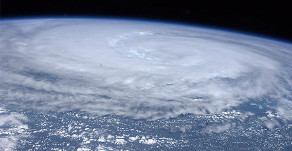
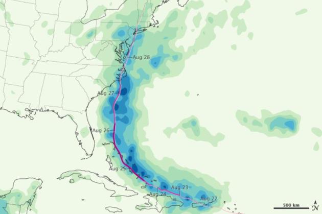
Hurricane Irene - Satellite Rainfall Estimates. Here's a post from NASA's
Earth Observatory, focused on satellite-derived rainfall measurements for Irene: "
Although hurricanes often call to mind raging winds and toppling trees, some of the worst destruction caused by these storms comes in the form of rain. Hurricane Irene, which roared up the U.S. East Coast in late August 2011, was no exception. Flooding was reported from North Carolina’s Outer Banks to New England. This color-coded image shows rainfall totals from August 22 to August 28, 2011. The heaviest rainfall—more than 240 millimeters or over 9 inches—appears in dark blue. The lightest rainfall—less than 40 millimeters or 1.5 inches—appears in light green. Superimposed on the rainfall totals is a storm track, with maroon indicating the strongest storm intensity, and pink indicating the weakest. Heavy rain occurs all along the storm track, and much of the heaviest rain falls over the ocean. On land, however, Hurricane Irene brought rain heavy enough to cause destructive floods."
Intensity Of Hurricane Still Bedevils Scientists. This has been a consistent challenge ever since the advent of supercomputer weather modeling in the 1960s - models do a fairly good job predicting the track of hurricanes (margin of error is 200 miles for a 4 day forecast), but intensity is far more problematic. Small eddies of warm water below the storm can spark rapid intensification - while wind shear aloft can shred a hurricane and weaken it considerably. In addition, hurricanes go thru cycles. "Eyewalls", the raging donut of T-storms ringing the calm eye, go thru "regeneration cycles", a new eyewall replaces a previous eyewall, and this can cause a hurricane to sputter and temporarily lose strength. The
New York Times has more: "
For scientists who specialize in hurricanes, Irene, which roared up the Eastern Seaboard over the weekend, has shone an uncomfortable light on their profession. They acknowledge that while they have become adept at gauging the track a hurricane will take, their predictions of a storm’s intensity leave much to be desired. Officials with NOAA’s National Hurricane Center had accurately forecast that Irene would hit North Carolina, and then churn up the mid-Atlantic coast into New York. But they thought the storm would be more powerful, its winds increasing in intensity after it passed through the Bahamas on Thursday. Instead, the storm lost strength. By the time it made landfall in North Carolina two days later, its winds were about 10 percent lighter than predicted. It’s not a new problem. “With intensity, we just haven’t moved off square zero,” Dr. Marks said. Forecasting a storm’s strength requires knowing the fine details of its structure — the internal organization and movement that can affect whether it gains energy or loses it — and then plugging those details into an accurate computer model."
Hurricane Irene's Price Tag May Exceed $7 Billion. More details from Gwen Ifill at
PBS.org:
"GWEN IFILL: It was a day for clearing away the mess and calculating the cost along the path of Hurricane Irene. The scope of the wreckage was less than feared, but the storm did kill at least 35 people in 10 states and triggered ongoing floods.
Irene was long gone today, but a weekend of storm-driven downpours left behind a trail of damage, sometimes to lethal effect.
CRAIG FUGATE, Federal Emergency Management Agency: We have seen record flooding in Vermont, record flooding in New York. We still have rivers that have yet to crest. The river forecast center for the Northeast was reporting that some of these rivers may not crest for two to three days. So, the extent of impacts, we still don't know.
GWEN IFILL: Officials said the flooding in Vermont was the worst in at least 80 years. It swept away historic bridges more than 100 years old.
WOMAN: Oh, my God.
GWEN IFILL: In Upstate New York, streams turned into swollen torrents, leaving roads impassable and entire communities cut off. And in Pompton Lakes, N.J., a house exploded into flames and burned amid the floodwaters, possibly from a gas leak. The storm also knocked out power to nearly 7.5 million homes and businesses along the East Coast.
Governors in Connecticut and Maryland warned today it could take some time to turn the lights back on."
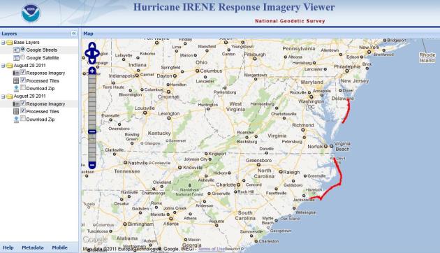
Hurricane Irene Response Imagery Viewer. Here's a
powerful (interactive) tool from NOAA, showing damage and clean-up efforts related to Hurricane Irene.
After Hurricane New Yorkers Hardly Miss A Beat. Yes, the storm surge was over-estimated (by some in the media), while the scope of inland flooding was probably underestimated, especially across northern New England. Irene was a blunt reminder that tropical storms can be just as deadly (in terms of flooding rains) as hurricanes. More on the "aftermath" in New York City from
businessweek.com: "
When the clouds parted, Wall Street wasn't swamped. Coney Island's world-famous Cyclone roller coaster was still standing. The Empire State Building hadn't lost a single window. And New Yorkers hardly missed a beat after Irene -- a hurricane demoted to a tropical storm just before it made it to the big city -- swept through Sunday morning. Just hours after an all-night, window-rattling drenching from the storm, people were back on the streets, jogging, milling around Times Square, walking dogs and surveying the damage, which consisted mostly of downed trees, power outages and neighborhood flooding. The subway system, shut down Saturday because of the risk of flooding, was still out of service, and trains probably won't be running in time for the Monday morning commute, meaning it could be a hellish start of the work week for millions of New Yorkers. But for a while at least, "it was a fun little adventure," said Zander Lassen, who spent the night at a boathouse in lower Manhattan babysitting beached sailboats." (photo courtesy of Porfolio.com).
Hurricane Irene: Are You Set To Fight Your Insurer? Here's a timely article from
Reuters: "
The morning after Hurricane Irene blew through their Takoma Park, Maryland, neighborhood, homeowners Michael Desautels and Susan Hearn awoke to find a giant holly-leafed cherry tree nestled precariously in some broken tiles on their roof. Hearn called State Farm, the company that holds their homeowners policy and boasts on its web site, "we're here to help... Ready to respond to Hurricane Irene." After the usual press-one-press-two roundabout, she heard a recorded message: "We are experiencing extremely high call volumes, please call back later." Click. And Hearn was disconnected. She finally got through to her insurance company the following day. Sigh. With more than a million homeowner claims and billions of dollars of damages expected to result from the storm's violent trip up the U.S. East Coast, it's not surprising that the path to an insurance settlement might not be smooth. "
Should Taxpayers Subsidize Flood-Prone Homes. An excellent question. Many people that live along major streams and rivers experience flooding every couple of years, relying on (federal) flood insurance to rebuild. Is this rational, or at some point should we (as tax payers) say "enough"? Here's a story at the
Washington Post: "
Rep. Michele Bachmann (R) called Hurricane Irene a wake-up call from God to rein in federal spending. Perhaps, but if God hates federal spending, he has a funny way of showing it: There’s no question that the disaster will rack up governments costs in the short run, particularly when it comes to flooding from the hurricane’s rain and coastal surges. Private insurers rarely cover offer flood protection, believing that the risk is far too high in most cases. Instead, the National Flood Insurance Program — created in 1968 and currently run by FEMA — covers about 5.5 million homes across the country, insuring flood-prone communities that take steps to manage their floodplains. Even when private insurers are contracted, “the profits from such flood insurance are private, but the losses are socialized as private insurance companies bear none of the underwriting risk associated with this insurance,” as economist Don Taylor explains. Either way, taxpayers are ultimately on the hook when these flood-prone homes go under water. The program was originally intended to pay for itself, but since Hurricane Katrina, it’s been heavily in debt. As of March 2011, the NFIP owes $17.8 billion, and Irene will only add to the costs, particularly as New York and New Jersey have heavy concentrations of federal flood protection. The NFIP’s fiscal troubles have prompted the Government Accountability Office to put the program on its “high risk” list, urging reforms to help balance its budget and “limit taxpayers exposure.”
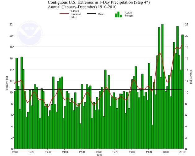
Climate Extremes Index. Is our weather becoming more extreme, or is this merely perception vs. reality? It's true that more people are living in harm's way (on the coast, next to rivers prone to flooding - more subdivisions in what was farmland making tornado strikes far more deadly). But beyond these factors, there appears to be an uptick in extreme weather since 1990. Here's is more on NCDC's "
Climate Extremes Index", or CEI. NCDC is a division of NOAA: "
How has the climate changed over the past 50 or more years? In what ways and by how much? Many people, including climatologists, have been struggling with these questions for some time now, not only for scientific interest, but also to aid in policy decisions (IPCC 2001) and to inform the general public. In order to answer these questions, it is important to obtain comprehensive and intuitive information which allows interested parties to understand the scientific basis for confidence, or lack thereof, in the present understanding of the climate system. One tool, first developed as a framework for quantifying observed changes in climate within the contiguous Unites States, is the U.S. Climate Extremes Index (CEI)."
Parts Of Britain Suffer Coolest Summer In 2 Decades. What a strange weather pattern - while much of the southern USA cooks, residents of the U.K. are wandering around in sweatshirts and light jackets. The U.K.
Telegraph reports: "
As Britons return to work today after a soggy Bank Holiday weekend, official weather data reveals that average temperatures were significantly down on recent years. The UK’s average temperature from June 1 to August 15 was only 57F (13.9C) – the lowest for 13 years. For central England the average was 59F (15C), making it the coolest summer since 1993."
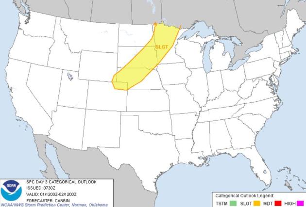 Thursday Severe Threat.
 An approaching cool front may spark strong to severe T-storms Thursday, most likely from northern and central Minnesota southwestward to Colorado. Source: SPC.
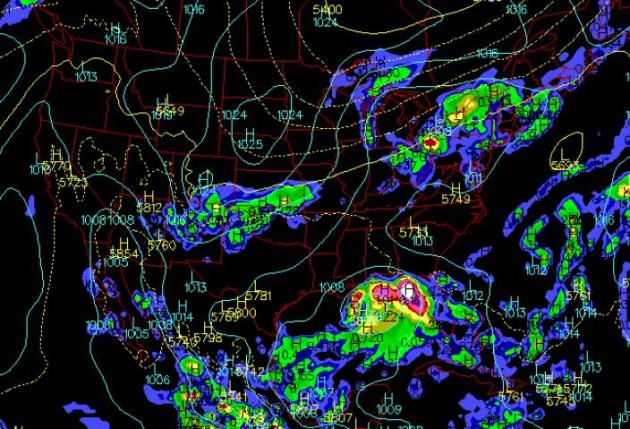
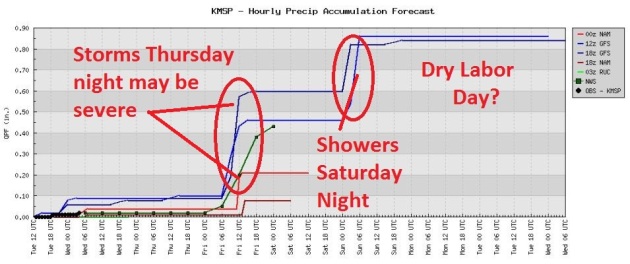 Rainfall Trends
. The best chance of showers and T-storms: Thursday night, as a cooler front approaches from the Dakotas. A few instability showers are possible with a reinforcing (second) cool front Saturday night. Right now Labor Day appears dry, with more sun, less wind, and low humidity. Early next week should feel like September.
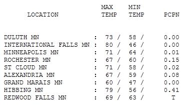
Soggy Tuesday. Showers were in the forecast, but in truth, it turned out cloudier and wetter than predicted. Those clouds kept temperatures cooler, only 71 at St. Cloud and the Twin Cities. Where the sun was out, the mercury shot up to 80 at International Falls. Rainfall amounts were light - the most rain: .41" at Hibbing.
 Paul's Conservation Minnesota Outlook for the Twin Cities and all of Minnesota:
WEDNESDAY: Damp, gray start, becoming partly sunny and humid PM hours. Dew point: 65. Winds: S 10. High: 81
WEDNESDAY NIGHT: Patchy clouds, warm and humid. Low: 73
THURSDAY: "Heat spike". Dew point: 70. Hot sun. T-storms late Thursday & Thursday night may be strong to severe. High: 95
FRIDAY: Windy, few showers, then gradual clearing, turning less humid. Low: 57. High: 75
SATURDAY: Sunny start, rain at night. Dew point: 58. Low: 57. High: 75
SUNDAY: Cool breeze, some sun early, clouds increase, PM showers (especially north). Low: 56. High: 69
LABOR DAY: Blue sky returns, best day of the holiday weekend with less wind. Low: 53. High: 74
TUESDAY: Plenty of sun, milder breeze. Low: 57. High: 77
No Mocking Please
A CNN post from comedian Dean Obeidallah caught my eye. "People ask: How can the weathermen be wrong so often? Here is the simple answer: They are trying to predict the future! It's a forecast, meaning a prediction about an event yet to happen. And to make it more challenging, they are dealing with the weather, which to me, is a mystical, awe-inspiring creature. How can anyone know for certain what this supernatural beast will do?"
"My point is simply this: We must recognize that these weather people are doing the best they can to predict the future. And for that, we should praise, not mock them, because if we continue to do so, there may come a day when they stop sharing their prognosticating gifts and instead leave us like cavemen to predict weather based on the sounds of insects and our swollen feet."
Thanks Dan. I needed that.
Today may be the best fair day this week; enough sun for 80. Mid 90s return tomorrow, but any discomfort will be brief. Windblown showers on Friday mark the leading edge of Canadian air. A sunny start Saturday gives way to rain Saturday night; by Sunday there will be no doubt in your mind that September has arrived. Dust off the jacket eh?
"Media Overhyped Irene To Boost Obama, Boost Global Warming Theory: Limbaugh. Oh my. Rush is off his meds again. Here's the story from the
International Business Times: "
Radio host and arch-conservative Rush Limbaugh said that President Barack Obama was ‘hoping’ that Hurricane Irene would become a major catastrophe and that most of the mainstream media over-hyped the magnitude of the storm in order to boost Obama and "push the leftist agenda.” “The hysterical reporting on Irene? They couldn’t wait for this storm. I'll guarantee you Obama was hoping this was going to be a disaster as another excuse for his failing economy," Limbaugh said on his show Monday (the nation’s number one radio program). "If he's out there blaming tsunamis, blaming earthquakes, this one [was] made to order, but it just didn't measure up." Limbaugh also fired some volleys at the mainstream media for their coverage of the storm. "You know how the media lies, how politicized everything is to push the leftist agenda," he said. "You know how the media distorts."
Obama: The Catastrophe President. Here's a post from msnbc and
salon.com: "
By the end of August 2011, President Barack Obama had already made 181 FEMA disaster declarations, solidly smashing the record 157 declarations made by Bill Clinton in 1996. For some on the right, it's all about the relentless expansion of Big Government -- the "federalization of fairly routine disasters," as Matt Mayer, the president of the conservative think tank Buckeye Institute for Public Policy Solutions, wrote in a blog post for the Heritage Foundation website. We can leave it to residents of Vermont to decide whether the flooding in the aftermath of Hurricane Irene qualifies as "routine" or not, but there's also another explanation: 2011 has been a banner year for disasters, period. By mid-year, according to the National Oceanic and Atmospheric Administration, 2011 was already one of the most extreme -- and costly -- years on record. And that was before Hurricane Irene.
From Scientific American:
"Just shy of the halfway mark, 2011 has seen eight $1-billion-plus disasters, with total damages from wild weather at more than $32 billion, according to the National Oceanic and Atmospheric Administration. Agency officials said that total could grow significantly, since they expect this year's North Atlantic hurricane season, which began June 1, will be an active one."
* Irene is now the 10th billion dollar weather disaster so far this year in the USA, a new record (old record was 9 separate billion dollar disasters in 2008).
Betting The Farm Against Climate Change. Here's a story from
kansascity.com: "Leon Trotsky is reputed to have quipped, "
You may not be interested in war, but war is interested in you." Substitute the words "climate change" for "war" and the quote is perfectly suited for the governors of Texas, Oklahoma and New Mexico, all of whom have ridiculed or dismissed the threat of climate change even as their states suffer record-breaking heat and drought. In his book, "Fed Up!" Texas governor and presidential aspirant Rick Perry derided global warming as a "phony mess," a sentiment he has expanded on in recent campaign appearances. Susana Martinez, the governor of New Mexico, has gone on record as doubting that humans influence climate, and Mary Fallin of Oklahoma dismissed research on climate change as a waste of time. Her solution to the extraordinary drought: pray for rain (an approach also endorsed by Perry). Although they may dismiss climate change, a changing climate imposes costs on their states and the rest of us as well. In Texas, the unremitting heat has been straining the capacity of the electric grid, killing crops and livestock, and threatening water supplies. As reported in The Wall Street Journal, the grid's governing body, the Electric Reliability Council of Texas, bases its forecasts on the average demand over the previous 10 years. In a world without the threat of global warming, this is an entirely reasonable approach. But what if climate change makes the past an unreliable guide to the future? Then Texas is left with the present situation, in which the grid operator is forced to procure power in a tight market where wholesale prices have skyrocketed to 60 times normal."


No comments:
Post a Comment