TODAY: Mostly cloudy, cool wind. winds: NW 10-15 High: 55
THURSDAY NIGHT: Partly cloudy. Low: 43
FRIDAY: Intervals of sun, light winds - a nicer day. High: 63
SATURDAY: Mix of clouds and sun. Winds: SE 10 Low: 46. High: 66
SUNDAY: Partly sunny and milder. Low: 48. High: 69
MONDAY: More sun, hard to concentrate. Low: 51. High: 71
TUESDAY: Indian Summer, take the day off! Low: 53. High: 74
WEDNESDAY: Spectacular weather holding pattern. Sunny and pleasant. Low: 55. High: 73
No rain in the forecast from Friday through the end of next week.
70s likely from next Tuesday through the first week of October.
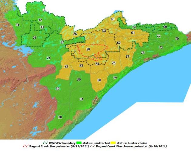
* The Pagami Creek Fire (BWCA of Minnesota) is now 30% contained. The size decreased to 93,669 acres because of more accurate GPS mapping on the northwest side. Of the total acreage, 9,274 acres are outside the wilderness. Between two tenths to one half of an inch of rain fell on the fire yesterday. Eleven canoes were airlifted into Insula Lake on the eastern side of the fire for incoming crews. Photo courtesy of Tim Gellenbeck.
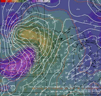
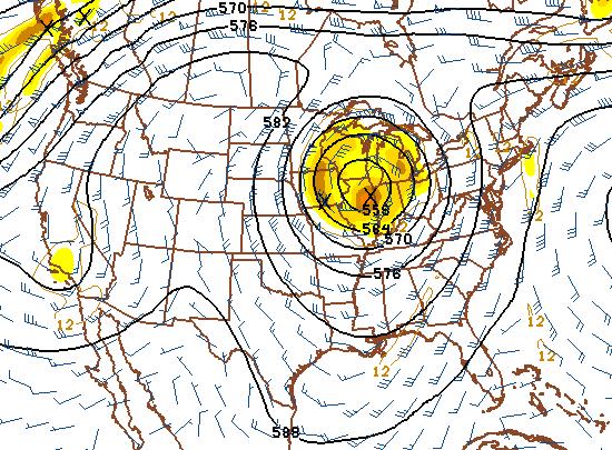
"Vertically-Stacked Low Pressure System". Say what? "Cut-off low" is easier to say, but it's the same thing. As storms mature they slow down, even stall out - instead of lagging the surface low, cold air swirling directly above the area of low pressure. Once these spinning puddles of unusually cold air break off from the main jet stream they can be very persistent, lingering for 3-6 days at times. More from the local NWS office: "This system is referred to vertically stacked because the center of the low pressure system at the surface coincides with the center of the low pressure system at various pressure levels through the depth of the troposphere. Typically, a vertically stacked low is either a mature system, or has already begun decaying. Strengthening low pressure systems are often tilted vertically, so the low at the surface will not coincide with the low in the upper troposphere in that case."
Weekend "Cut-Off Low". A nagging storm in the upper atmosphere will keep patchy clouds, even a few PM instability showers close to home Saturday and Sunday, the best chance of showers over Wisconsin and southeastern MN. The sun should be out from the Red River Valley into the Dakotas. In general the weather gets sunnier/milder the farther north/west you travel across Minnesota this upcoming weekend.
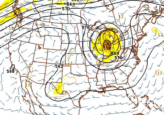
Next Wednesday: Retreating Low, Increasingly Mild. Next week the holding pattern finally breaks down, the storm in the upper atmosphere pushes east, leaving us increasingly sunny and increasingly warm. Odds favor 70-degree sunshine from the middle of next week through much of the first week of October, even a few days with highs near 80.
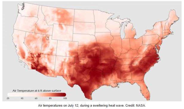
(NWS) According to climate records, State College, PA has already doubled the amount of rain it got last year.
Precipitation:
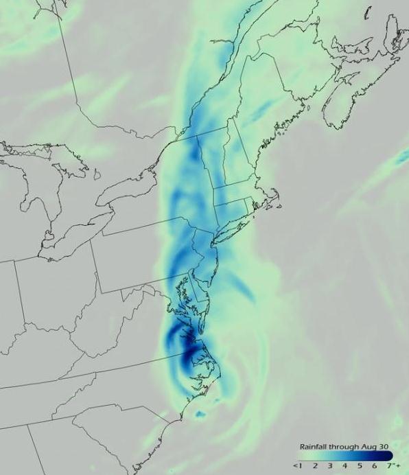
Precip last year total: 28.09 in
This year since Jan 1: 57.22 in
In the month of September:13.83 in
Precipitation:
Precip last year total: 28.09 in
This year since Jan 1: 57.22 in
In the month of September:13.83 in
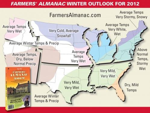
Florida. A very active storm track will bring much heavier-than-normal precipitation from the Southern Plains through Tennessee into Ohio, the Great Lakes, and the Northeast. Because of above normal temperatures, much of the precipitation will likely be rain or mixed precipitation, although, during February, some potent East Coast storms could leave heavy snow, albeit of a wet and slushy consistency. An active Pacific Storm track will guide storm systems into the Pacific Northwest, giving it a wetter-than-normal winter. Drier-than-normal weather will occur in the Southwest and Southeast corners of the nation."
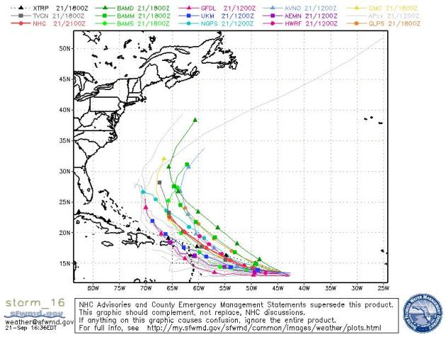
When Hurricane Irene made landfall on North Carolina's Outer Banks, it became the first hurricane to hit the United States in nearly three years. An active hurricane season has slowed down in recent days, but more storms are forecast for the late season in fall. So far there have been 14 named storms (which include tropical storms as well as hurricanes),three hurricanes and two major hurricanes (Irene and Katia). Predictions had called for this season to be a doozy, with 14 to 19 named storms, seven to 10 hurricanes, and three to five major hurricanes (Category 3 or higher). Irene came dangerously close to dealing a serious blow to New York City. It devastated New Jersey, upstate New York and Vermont with severe flooding. The storm became 2011's 10th billion-dollar weather disaster." (map above courtesy of NOAA).
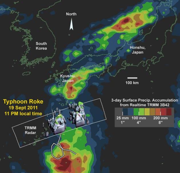
Photo credit above: "This large-scale image provides context for the 3D radar data (in gray) by showing the three-day surface rainfall accumulation (rainbow colors) along the track of the storm (gray line). Also shown is the significant rainfall accumulation (over 200 mm or ~8 inches) over the Japanese Island of Kyushu to the north of Typhoon Roke. Credit: NASA/TRMM/Owen Kelley "
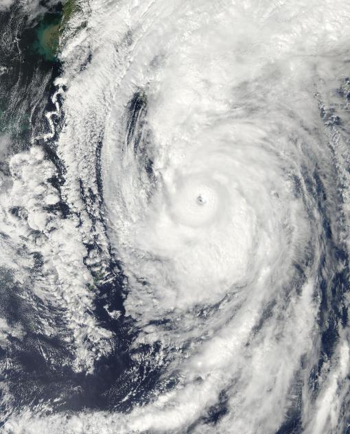
* Tropical Storm Roke is just off Japan’s North East Coast as of noon New York time (Wednesday) with winds of about 80 miles an hour. Roke made landfall today with sustained winds of about 100 miles an hour.. equivalent to a Category 2 hurricane. Good news from Fukushima.. home of the damaged nuclear plant from the March Earthquake and Tsunami. The area got several inches of rain but was spared damaging winds. Forecasters say Roke could bring rains to British Columbia and the U.S. Pacific Northwest next week. - source: Business Week.
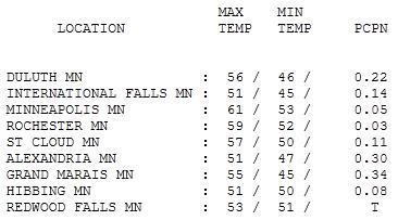
Cloud-Cluttered. A slow-moving storm in the upper atmosphere (unusually cold air aloft) kept Minnesota gray, windy and showery Wednesday. Rainfall amounts ranged from .03" at Rochester to .34" at Grand Marais. HIghs were stuck in the 50s, but the Twin Cities managed to sneak up to 61 F.
"Siren Fatigue"
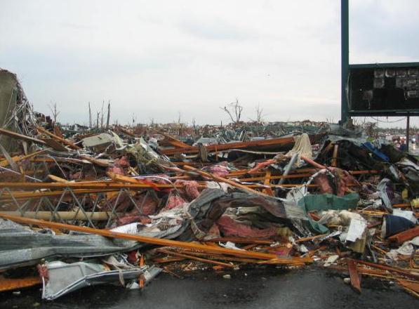
A new NOAA study suggests that many residents of Joplin, Missouri ignored the sirens on May 22. The EF-5 tornado was "rain-wrapped", so big it didn't resemble a conventional funnel. 162 residents died in less than 15 minutes, many of these deaths ultimately preventable. How can the system be improved? So many (rotation-based) tornado warnings are issued that many people tune out. They believe NOAA and local media are "crying wolf" or "just covering their butts." One suggestion: when a tornado is actually on the ground it's no longer a tornado warning but a "TORNADO EMERGENCY".
Don't rely on the emergency outdoor sirens. Tap smartphone apps, NOAA weather radio, TV, web, radio and e-mail; the more "safety nets" the better.
A storm stalled over the Great Lakes, "cut off" from the main jet stream, keeps a pinwheel of clouds and sprinkles spinning above our heads today. A ridge of high pressure builds in over the weekend, promising more sun and highs in the 60s. In fact, a run of 70s arrives next week, a few 80s the 1st week of October.
Our autumns have been trending longer/milder since about 1990. I suspect October will be a terrific month. The winter outlook? "Changeable". Take it to the bank.

Bill Clinton: GOP Climate Skeptics Make America Look Like "A Joke". The story from CBS News: "Former president Bill Clinton on Tuesday lambasted the field of Republican presidential contenders for their resistance to climate change science - and argued that their skepticism on the topic was making America look like "a joke." The former president, speaking at an event kicking off the Clinton Global Initiative's seventh annual conference in New York City, urged Americans to force the collective acknowledgment of climate change among conservative politicians. "If you're an American, the best thing you can do is to make it politically unacceptable for people to engage in denial" about climate change, said Clinton, according to Politico. Calling the lack of attention to the issue "really tragic," Mr. Clinton said that Americans could help push change by refusing to vote for climate change skeptics. "I mean, it makes us - we look like a joke, right? You can't win the nomination of one of the major parties in the country if you admit that the scientists are right? That disqualifies you from doing it? You could really help us there," Clinton said."
Fighting Climate Change Is Not About Environmentalism. Here's an interesting post from The Atlantic: "I've been kicking around an idea recently that crystallized in the form of a short "Room for Debate" op-ed on green jobs that I wrote for The New York Times yesterday. Here's the relevant snip: "The president should remind people that stopping global warming isn't about nature or "saving the planet." Some set of plants and animals will survive. Human infrastructure is what's in danger. We've built cities predicated on one climate and now those places have a new one. Climactic chaos is expensive." The nugget of the argument here is the framing fighting climate change as a way to help nature is flawed. Even in a really clear example of climate-induced ecological change -- the loss of many species in the forests Thoreau explored near Walden Pond -- other species are doing just fine. We're changing the ecosystem, but life isn't leaving the forest. We're applying a very certain kind of filter on the forest (specifically, which plants can change their flowering time quickly) but life there survives because ecosystems, even those stressed by rising temperatures, are resilient. Human-built environments, on the other hand, are very efficient and very brittle. They function best in a very narrow set of temperature and precipitation conditions. Witness what happens when it snows in Portland or it gets very hot in a cold place or it rains somewhere where it's always dry. A people as rich as Americans can deal with any climate, but only if we put the right infrastructure in place. People in Buffalo have snow plows. People in Phoenix have air conditioners."
No comments:
Post a Comment