73 F. high in the Twin Cities Tuesday.
35 mph wind gust shortly before 7 pm at MSP.
1 in 22 trillion: odds that you will be personally impacted by falling NASA satellite debris from Thursday into Saturday.
1 in 1 million: odds that you'll be struck by lightning within the next 12 months.
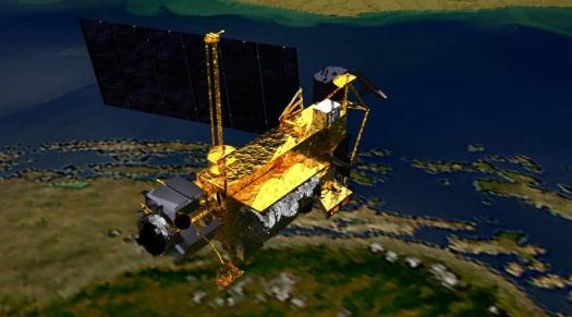
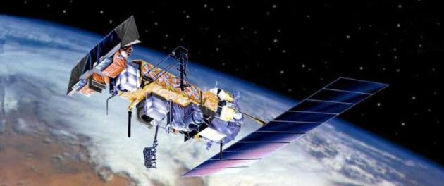
RIP. More on NASA's UARS satellite forecast to crash to Earth on or around Friday: "The satellite, launched in 1991 from the Space Shuttle, was the first multi-instrumented satellite to observe numerous chemical constituents of the atmosphere with a goal of better understanding atmospheric photochemistry and transport." (courtesy of NASA).
 Typhoon Roke
 is pushing into southern Japan with 110 mph+ winds. Over 1 million residents of coastal Japan have evacuated to higher ground - more details below.
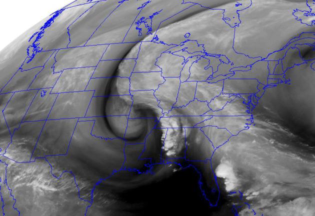 "Cut-Off Low"
 The 500 mb map, valid 1 pm Saturday, shows a swirl of cold air aloft, cut off from the main jet stream. This upper level storm will spark clouds and showers over the Great Lakes, possibly brushing eastern and central MN with patchy clouds, especially PM hours on Saturday into a portion of Sunday. 70-degree sunshine will probably be delayed until later next week.
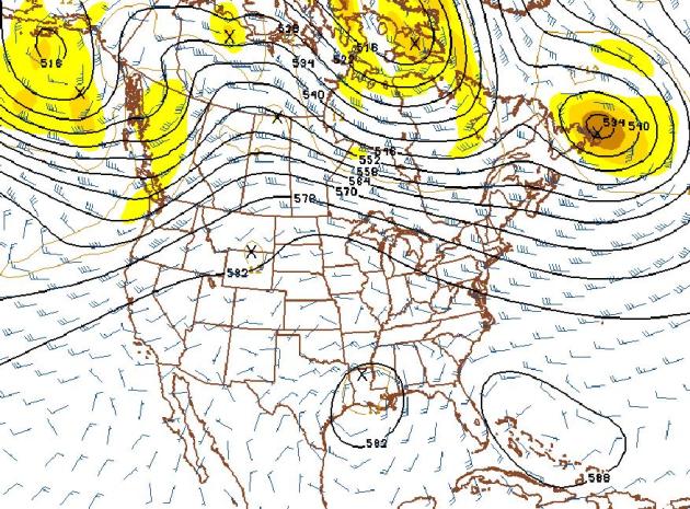
Indian Summer Spills Over Into Early October? The 500 mb map above, valid October 5, looks like something out of mid August - the core of the jet stream lifting into central and northern Canada, leaving most of the USA under a warm ridge of high pressure, good for 70s and 80s, even some 90s over the southern USA. Bottom line: don't pack away the summer wardrobe just yet.
“...
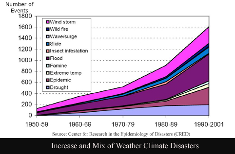
All weather events are now influenced by climate change because all weather now develops in a different environment than before,” according to the group Climate Communication, in a report released shortly after Irene dumped record amounts of rain on the U.S. Mid-Atlantic and Northeast. This probably doesn’t seem like news to much of the eastern half of the country, where tropical storms and hurricanes dumped massive amounts of water in the past month, as well residents in Texas who are still coping with some of the worst wildfires in history." - article below on adapting to climate change.
Update: NASA Satellite Falling Faster Than Expected And Will Crash This Week.
Gizmag.com has the latest: "NASA employees are now holding their breath as the 6.6 ton (6 tonne) out-of-control Upper Atmosphere Research Satellite (UARS) is falling faster than previously expected. Yesterday, NASA announced that the decommissioned satellite is most likely to crash into the earth's surface on Friday 23 September ... give or take a day. UARS will come crashing back to Earth after it was placed into orbit almost twenty years ago. Although the spacecraft will break into pieces during re-entry, not all of it will burn up in the atmosphere beforehand. It is anticipated that 26 large fragments of the UARS satellite will actually fall to Earth, in a rain of debris altogether weighing about 1,170 pounds/532 kg (the largest weighing 300 pounds/150 kg). More information is available in our
original article."
More details on the UARS satellite at NASA's web site
here.
Perspective. The
Capital Weather Gang's Jason Samenow has a terrific article putting Friday's satellite risk into perspective. Bottom line: don't lose any sleep over this one: "
But, objectively, no one should be panicking or heading into a bunker. A 1-in-22 trillion risk of being hit is truly small. So let's look at how this risk compares to the risk of being struck by lightning. According to NOAA, the odds of being struck by lightning in a given year are 1-in-a million. Scaling that down over a period of three days, the window during which the satellite debris may rain down on Earth, the odds drop to about 1 in 120 million. So if we compare the odds of being struck by lighting or being hit by satellite debris Thursday through Saturday, you’re about 180,000 times more likely to be struck by lightning."
Japan Urges Mass Evacuation Ahead Of Typhoon Roke. Here's an update on a very dangerous storm from the
BBC: "
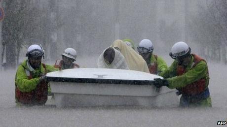
More than a million people in central and western Japan have been urged to leave their homes as a powerful typhoon approaches. Japan's Meteorological Agency warned that heavy rains brought by Typhoon Roke may trigger landslides and floods. The storm is packing winds of 144km/h (90mph) and is expected to strengthen. More than 460,000 households have been ordered to evacuate in Nagoya city, Aichi Prefecture, where it is feared nearby rivers may burst their banks. Television footage showed Nagoya residents wading through water up to their knees. In some parts of the city rescue workers had to transport people in inflatable boats."
Japan Evacuates In Preparation For Typhoon Roke. Here's an update from
NOAA: "
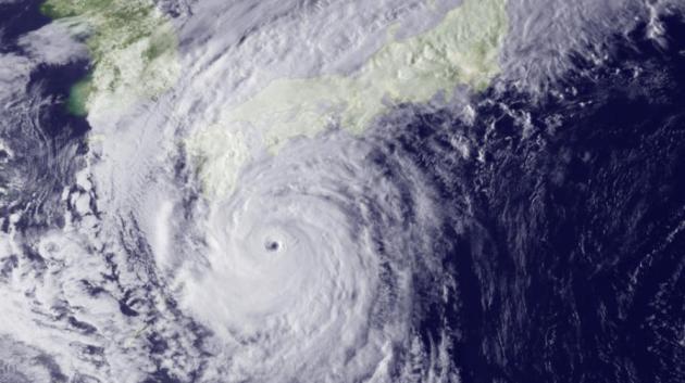
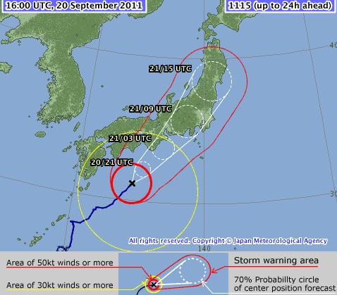
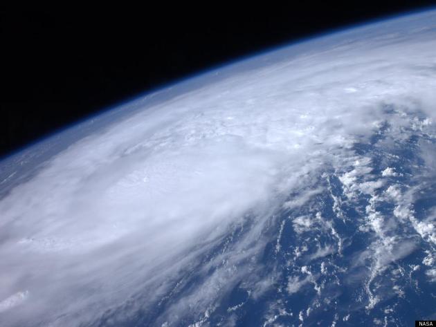
Currently around 180 miles south of the Japanese mainland, Typhoon Roke is moving north-northeast with maximum sustained winds of around 110 mph. In preparation for an expected landfall just west of Tokyo on September 21st at 0600z, evacuations have begun in many coastal and low-lying areas. This image was taken by the Japan Meteorological Agency's MTSAT weather satellite on September 20, 2011 at 0730z."
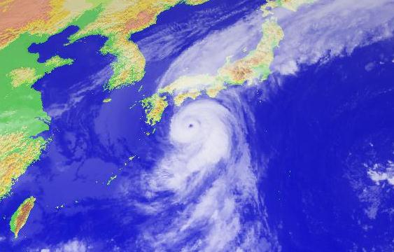
Typhoon Roke. Sustained winds are 110 mph - an estimated 1.3 million people have been ordered to evacuate. The typhoon (same thing as a hurricane) is forecast to track right up the east coast of Japan, drenching the country under 10-15" of rain, impacting millions of residents.
Direct Strike? Tokyo and Osaka may both be severely impacted by Typhoon Roke. Winds will diminish rapidly upon landfall, but a 5-10 foot storm surge may sweep into Tokyo Harbor within 48 hours. Forecast track map courtesy of the
Japan Meteorological Agency.
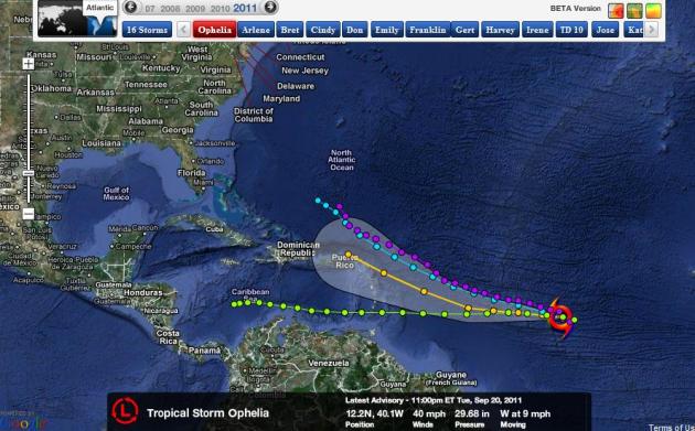 Tropical Storm Ophelia.
 We're up to the O's in the alphabet - Tropical Storm Ophelia was packing 40 mph winds last night. It may pose some risk to the Windward and Leeward Islands of the Caribbean by the weekend. Beyond that it's truly anyone's guess.
Lessons Learned From Hurricane Irene Can Help You Prepare For Future Disasters. Some useful information from
pr-usa.net: "
Hurricane Irene, with its high wind, torrential rain and flooding, was a wake-up call for the residents of many states up and down the East Coast of the United States, providing important lessons to millions of Americans on how to prepare for future storms, according to the Insurance Information Institute (I.I.I.). "Those who take the time to prepare for a disaster are in the best position to survive a catastrophe and recover as quickly as possible," pointed out Jeanne M. Salvatore, senior vice president and consumer spokesperson for the I.I.I. Hurricane season, which ends on November 30, is far from over so it is still possible for another storm to make landfall in the U.S. In fact, six of the ten most expensive hurricanes in the U.S. occurred in September and one in late October. Damage caused by wind is one of the most consistent and major causes of property loss. Hurricanes and tropical storms accounted for 44 percent of all catastrophe losses over the 20-year period from 1991 to 2010. Tornadoes, which frequently accompany hurricanes, ranked second highest, representing 30 percent of catastrophe losses for the period. Hurricane Irene provided a stark reminder that the entire East Coast is at risk for catastrophic storms. While Florida and the Gulf coast may have more frequent hurricanes, the Northeast also has a history of severe storms. The Great New England Hurricane of 1938 (also known as "The Long Island Express") hit New York, Connecticut, Rhode Island and Massachusetts, causing 600 deaths, 1,700 injuries and over $400 million in damages, according to the Massachusetts Executive Office of Public Safety and Security (EOPSS). AIR Worldwide estimates that the storm would have caused $38 billion in insurance damages had it occurred today."
NOAA: Weather Satellites In Jeopardy.
CNN has the story of what may happen if budget cuts impact NOAA's ability to launch new (polar-orbiting) weather satellites: "
It's easy enough to take for granted how much we know about the weather these days. Take Hurricane Irene: There are plenty of weather maps showing the path of that storm, which is churning through the Caribbean on its way to the East Coast of the United States. We have a pretty good idea of where Irene is heading and how strong it will be when it hits land. All of this, of course, gives people in North Carolina and elsewhere days to stock up on food and plan an escape route -- just in case these predictions come true. How do we know all this stuff? Because satellites are watching. That's the point the National Oceanic and Atmospheric Administration has been trying to make lately as it campaigns to avoid budget cuts to its program for monitoring the Earth's oceans and weather from above the atmosphere. Here's the most pressing point that NOAA's making: A significant weather satellite that orbits the Earth in a north-south direction will die in 2016. Unless funding is put in place soon, a new program to replace that satellite won't be ready nearly in enough time. In a series of public appearances, NOAA Administrator Jane Lubchenco has been underlining the importance of satellites in forecasting weather. At a meeting this month in Denver, she said there probably will be a gap of time when NOAA doesn't have any working satellites on a pole-to-pole orbit, according to The New York Times' Green blog. Those north-south satellites are "essential for supporting climate research as well as operational weather and storm forecasting for civil, military, and international partners," according to a White House budget document."
Mosquitoes Swarm From Breeding Grounds Left By Hurricane Irene.
USA Today reports on an unhappy symptom of a (much) wetter than average weather pattern for the eastern seaboard: "
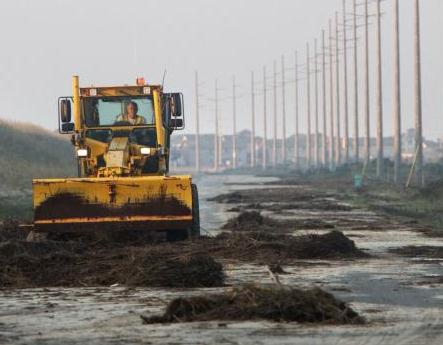
Hurricane Irene left more than broken windows and flooding in her wake. States along the East Coast are dealing with a larger than usual number of mosquitoes from residual water from the late-August storm, according to Joe Conlon, technical adviser for the American Mosquito Control Association. The aftermath of weather patterns such as Hurricane Irene provide pockets of water with ideal conditions for mosquito breeding grounds, Conlon said. "The mosquitoes that are plaguing the Mid-Atlantic area right now are a result of the hurricanes and tropical storms that have recently passed through," added Janet McAllister, an entomologist for the Centers for Disease Control and Prevention (CDC). Conlon noted North Carolina's Outer Banks, as well as areas of Virginia, Delaware, New Jersey and Massachusetts have been greatly affected by mosquitoes. Many affected areas have begun spraying insecticides to keep the mosquito population under control, Conlon added."
From The Fire: BWCA Forest Of The Future. The
Star Tribune reports on what firefighters have learned from the massive Pagami Fire: "
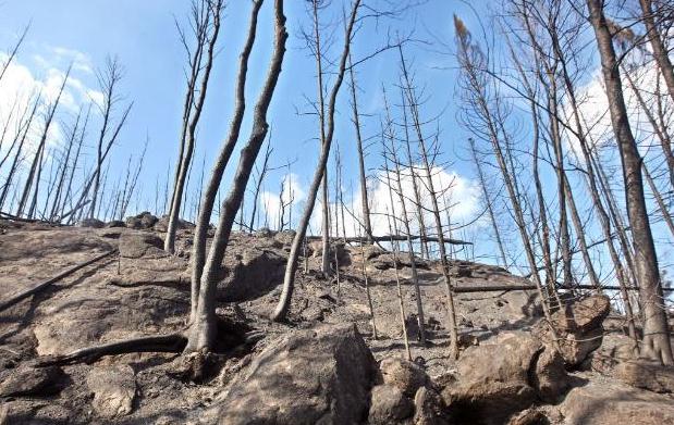
The fire burning in the Boundary Waters Canoe Area Wilderness is a routine event in the history of Minnesota's wilderness, one that has occurred periodically since long before there were kayaks and campfires. Although fires pose grave danger to life and property, they keep the woods young and healthy. This time, however, a different kind of forest is likely to emerge from the ashes -- one that will reflect the impact that climate change is working on all of Minnesota's famed North Woods. The Pagami Creek fire is expected to open a broad swath of forest to a new kind of landscape, one that will be less dense and include a mix of grassland, maples and oaks -- and possibly invasive species like buckthorn, forestry scientists say. This fire and future blazes "can help the forest make the transition that it needs to adjust to a warmer climate," said Lee Frelich, director of the Center for Forest Ecology at the University of Minnesota and an expert on boreal forests. Minnesota's woods are especially sensitive to the warming temperatures and extreme weather events of recent years. Many species of trees and animals in and near the BWCA, including jack pine and moose, are already at the southern end of their natural range. The region's thin soil makes trees especially vulnerable to stress and drought."
Masonry Can Help Weather Severe Storms. Although there's no such thing as a tornado-proof home, using concrete block and masonry can increase the odds of your home remaining intact during a severe storm.
The Canadian Concrete Masonry Producers Association has more details: "
Hotter summers. Heavier rain. More frequent severe storms. These are the effects of climate change, and while building owners can't directly control them, they can minimize their effects through the use of weather-resistant building materials such as concrete block, clay brick, and stone. While Environment Canada notes that global temperatures have risen less than one degree over the past 100 years, the agency points out that "even a modest warming of global temperatures would significantly change global wind and precipitation patterns, and hence alter local weather behavior around the world." The agency also notes that "The number and cost of extreme weather events/disasters (extreme storms, floods, heat waves, droughts, etc.) is rising and new thresholds, regulations, technologies and infrastructure codes and standards need to be developed now to improve the safety of Canadians." An example of that extreme weather manifested itself August 21, 2011 in Goderich, Ontario, where an F3 tornado and winds of 280 kmh killed one person and left parts of the town in ruins. While tornados are not unheard of in Canada, the Goderich storm shocked residents with the extent of its devastation. South of the border, the April 2011 "super outbreak" of tornadoes, which cut through the Southern, Midwestern and Northeastern U.S., is the largest tornado outbreak on record. "There's no doubt that our weather is becoming more severe, and building regulations today need to reflect that," says Paul Hargest, President of the Canadian Concrete Masonry Producers Association (CCMPA). "The right building materials are important not only in terms of durability, but also the heavier rain and hotter summers we're experiencing." Concrete block, brick and stone naturally resist moisture, which helps prevent mould, according to research coordinated by the National Research Council of Canada. Masonry also has the ability to absorb heat from the sun and release it over a period of time, helping to maintain more consistent temperatures in a building and reduce the need for air conditioning as well as lower heating costs. Masonry may help reduce storm-related fatalities as well. In states such as Alabama, which was especially hard-hit by the April super outbreak, the U.S. Federal Emergency Management Agency has helped fund the construction of masonry storm shelters and safe rooms. The National Storm Shelter Association (NSSA) has also held workshops to educate industry professionals and consumers on how to build these structures. NSSA-approved safe rooms can withstand 400 kmh winds and the impact of a 6-kg, 2 X 4 piece of lumber flying at 160 kmh. The worst of the storms that struck Alabama measured EF5 with winds surpassing 300 km/h."
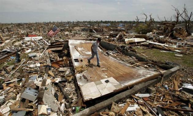
Most Joplin Residents Ignored Tornado Warning, Experts Find. MSNBC has some disappointing news - it turns out many of the deaths could have been prevented if locals had taken the warning seriously. Is this a function of tornado-warning-fatigue? Too many warnings? Too many false alarms? More details from
MSNBC.com: "
The vast majority of Joplin residents" did not respond to the first siren warning of the May 22 twister that killed 162 people because of an apparent widespread disregard for tornado sirens, federal officials concluded in a report issued Tuesday. "This was a warned event," Kathryn Sullivan, deputy director of the National Oceanic and Atmospheric Administration, told reporters, noting that several days before forecasters were warning of a strong possibility of twisters. Officials didn't blame residents, many of whom complained that sirens often go off in Joplin for tests or even just when dark clouds form, and suggested that a "non-routine warning mechanism" be developed to make it clear when a siren should be taken seriously. Keith Stammer, who heads the local county's emergency management agency, said the department issued two sets of sirens ahead of the tornado and that many people ignored the first siren. Some people thought a second siren was an all-clear signal, which it wasn't, he said. Stammer said he has never issued an "all-clear" during his 18 years in the department. "Honestly it was a bit of a disappointment that there were so many people who didn't move to shelter after the first warning," Stammer said. "The human side is the part that's most frustrating."
Italian Scientists Go On Trial For Failing To Predict L'Aquila Earthquake. This is vaguely terrifying. Has anyone told the Italian government that it is IMPOSSIBLE to predict earthquakes in advance? Everyone's looking for a scapegoat, I guess. Details from
My Fox New York: "
L'AQUILA, Italy - A group of Italian scientists went on trial Tuesday for failing to predict an earthquake that killed more than 300 people in central Italy in 2009 despite signs of increased seismic activity in the area. The seven defendants -- six scientists and one government official -- are accused of manslaughter in a case that some see as an unfair indictment of science. Prosecutors say residents around the city of L'Aquila in the mountainous Abruzzo region should have been warned to flee their homes in the days before the quake. "We simply want justice," L'Aquila prosecutor Alfredo Rossini said. The injured parties are asking for €50 million ($68 million) in damages. The defendants were members of a panel that had met six days before the earthquake to assess risks after hundreds of tremors had shaken the medieval university city. At that meeting, a committee analyzed data from the low-magnitude tremors and determined that the activity was not a prelude to a major earthquake."
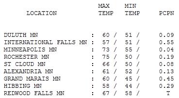
Wind-Whipped Tuesday. We got off to a showery start yesterday, but there were a few sunny breaks, enough for a high of 73 in the Twin Cities, 75 at Rochester. Tuesday's high in St. Cloud was 66 with .08" rain. Grand Marais picked up .45" with .55" reported at International Falls - welcome rain helped the 500-600 firefighters battling the BWCA blaze.
 Paul's Conservation Minnesota Outlook for the Twin Cities and all of Minnesota:
TODAY: Feels like mid October. Windy and cool with showers and sprinkles. Winds: NW 15-30. High: 53 (feels like low 40s).
WEDNESDAY NIGHT: Clouds and sprinkles. Low: 47
THURSDAY: Clouds linger, still chilly. High: 57
FRIDAY: Intervals of sun, less wind. Low: 46. High: 62
SATURDAY: AM sun, PM clouds. Cool breeze. Low: 47. High: 66
SUNDAY: Mix of clouds and sun. Brisk. Low: 45. High: 65
MONDAY: Chicago storm finally moves east. Sunnier day. Low: 48. High: near 70
TUESDAY: Bright sun, lukewarm. Low: 49. High: 72

Outlook: Space Junk
Friday's outlook: "Partly cloudy, chance of a rapidly falling satellite." We live with risk every day, from the morning commute to the ever-present risk of food poisoning and infection. Risk is a fact of life, however unpleasant.
A 6-ton NASA satellite the size of a double-decker bus is forecast to fall to Earth anytime Thursday into Saturday. Will NASA issue a "Falling Satellite Alert?" No idea. But I wouldn't worry too much. According to the Capital Weather Gang's Jason Samenow, the odds of being struck by the largest piece of space-junk in 30 years is 1 in 22 trillion. You are 180,000 times more likely to be struck by lightning; 110,000 times more likely to win the Powerball Grand Prize.
October swirls into town today on gusty winds and 50-degree showers, a hint of wind chill in the air. A cold swirl of air aloft will become cut off from the jet stream, spinning like a sloppy top over Chicago this weekend. Clouds and showers are likely closer to Madison, but this weather road-block may delay 70s until next week.
The sun should peek through this weekend, highs in the 60s.
Long range guidance shows a streak of 70s from next week into the 1st week of October. Patience.
The Ocean Depths May Be Hiding The Full Extent of Global Climate Change. The story from
io9.com: "
The last decade was the hottest on record, and yet it wasn't until 2010 that an individual year was hotter than the record-breaking 1998 heatwave. Somehow, global temperatures mysteriously flattened out. The explanation may lie thousands of feet underwater. Scientists have long been searching for the so-called "missing heat" to explain the disparity between expected rises in global temperatures and the actual, relatively small increases. Based on the rate of greenhouse gas emissions, climate scientists expected the 00's to be warmer than they turned out to be. In fact, our satellites were actually able to monitor the amounts of sunlight entering the atmosphere and radiation leaving it. Way more heat was getting in that getting out, so where was it all going?"
Al Gore And The Alternate Realities Of Climate Change.
Time magazine has the story: "
When will we face up to reality? That was the question Al Gore asked with his 24-hour, worldwide presentations on global warming last week in an online program he called Climate Reality. In the day's last speech — presented in person in New York City — Gore delivered a passionate condemnation of efforts by the fossil-fuel industry to spread doubt about climate science. He tied the recent rash of devastating disasters — heat waves and floods and storms — to rising carbon emissions and predicted more devastation on a warmer planet in the future. Most of all, he called on his audience of more than 8 million viewers online to act. "Climate change is not really a political problem," he said. "It's a human problem." In other words: wake up and smell the burning planet. Gore made the scientific consensus seem stronger than it really is — especially on the connection between rising temperatures and extreme weather events, which is still evolving. (As the environmental scientist Roger Pielke Jr. likes to say, climate models often serve as "ink blots" — people tend to read their own preconceptions into the data.) But Gore deserves credit for doggedly pushing his case in the face of obfuscation and outright lies from many of his opponents. And he is essentially right that a warmer future does not look good, to say the least. Just a day after Gore's Climate Reality event, researchers announced that the Arctic sea ice cover had melted to its second lowest level on record — another reminder that climate change doesn't care about politics and will continue to unfold whether we believe in it or not. (See photos of the top 10 green buildings in 2011.)"
What The Polls Really Show About Global Warming.
Minnpost.com has the details: "
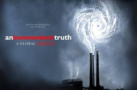
Are Americans turning their backs on global warming? Conventional wisdom is that we are, as demonstrated by opinion polls from recent years: concern over climate trends has declined, doubt about climate science has risen. Such polls — or at least the headlines and impressions they’ve generated — were a prime mover behind Al Gore’s reprise of “An Inconvenient Truth” via global webcast last week. But the polling picture is way more complicated than a couple of trend lines. If you look beyond the marquee surveys from Pew, Gallup and others that get the steadiest media attention, you’ll find that Americans’ views on climate issues are both fluid and nuanced, and that the opinions they share with pollsters are sensitive to just what they are asked, and when. For those of us who think global warming is both real and dangerous, and that immediate action to reduce greenhouse gases is necessary, the truth of American public opinion is not so much inconvenient as inconsistent, occasionally incoherent — and in some respects encouraging."
Climate Change And America's "Deadly" National Parks. The story from
truthdig.com and Mother Jones: "
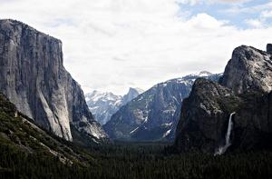
After learning that tourist deaths in Yosemite National Park increased this season compared with a typical year, Mother Jones reporter Kiera Butler asks whether the events that are rearranging the Earth’s climate might be the culprit. Scientists are unwilling to label climate change as the direct cause of the lives lost by environmental alterations, such as faster-moving, higher-volume river water. But they are paying attention to the connection between rising temperatures and hazardous conditions. A 2006 report by the Natural Resources Defense Council found that in wilderness areas in the American West, unusually high temperatures led to heat waves, insect infestations, increased storms and flooding. Elsewhere this year, at Virginia’s Colonial National Historical Park, rising sea levels forced officials to move a lighthouse building twice."
Climate Change Is Here. Let's Adapt To It Now. I fear that's exactly what we're going to have to do - adapt. For a variety of reasons the odds of making a meaningful dent in greenhouse gas emissions in the near future are remote. The 21st century will be all about adapting to a warmer/stormier atmosphere, as profiled in this article from
care2.com: "
Climate change is a tricky business. Scientists consistently (and rightly) remind us that you can’t pin any individual storm or drought or hurricane on climate change – there are too many variables, and climate change is just one of them (albeit a rapidly growing one). However, the vast majority of the world’s climate scientists tell us that the new extremes of weather plaguing the United States and other countries are part of a trend that they expected from global warming, and will get worse. Computer models from way back in 2007 are proving accurate in predicting the types of weather that we should expect. And in a new report from Climate Communication, renowned scientists spell out in detail how climate change has become the driving factor behind all current weather events. “All weather events are now influenced by climate change because all weather now develops in a different environment than before,” according to the group Climate Communication, in a report released shortly after Irene dumped record amounts of rain on the U.S. Mid-Atlantic and Northeast. This probably doesn’t seem like news to much of the eastern half of the country, where tropical storms and hurricanes dumped massive amounts of water in the past month, as well residents in Texas who are still coping with some of the worst wildfires in history."
Insurance Not Liable For Global Warming Claims. The
New American has the story: "
The Virginia Supreme Court has ruled in favor of an insurance carrier in an unprecedented case involving global warming. The court unanimously held that Steadfast Insurance Company is not obligated to cover court costs for the Virginia-based energy group AES Corporation under its liability policy in another lawsuit before the Ninth Circuit Court of Appeals in California.AES is one of 24 companies sued in that case by an Alaskan coastal village for damage to its community from global warming. The villagers of Kivalina blame greenhouse gas emissions from the defendants' business operations for shoreline erosion they say will force relocation of their town. The ruling for Steadfast sets a precedent that businesses involved in climate change liability lawsuits may not be covered by their liability policies. In AES Corp. v. Steadfast Insurance Co., the utility argued Steadfast had a duty to defend because Kivalina accused AES of negligence, a provision covered in its liability policy. The Virginia court ruled that Kivalina's claims do not amount to negligence or an accident but that AES acts intentionally in emitting greenhouse gases. Justice S. Bernard Goodwyn wrote, "Kivalina plainly alleges that AES intentionally released carbon dioxide into the atmosphere as a regular part of its energy-producing activities. Kivalina also alleges that there is a clear scientific consensus that the natural and probable consequence of such emissions is global warming and damages such as Kivalina suffered. Whether or not AES's intentional act constitutes negligence, the natural and probable consequence of that intentional act is not an accident under Virginia law." (photo credit
here).








No comments:
Post a Comment