47-50 F. dew point by Sunday & Monday, less than half as much water in the air than Thursday.
24.3" rain predicted for portions of southern Louisiana by Monday from a disturbance in the Gulf of Mexico that will, in all probability, strengthen into Tropical Storm Lee.
66 days above 100 F. so far this summer season in Dallas/Fort Worth.
96 days above 100 F. at Wichita Falls, Texas.
41 days above 100 F. at Houston, Texas.
93.9 F. average August temperature in Las Vegas (hottest August on record).

Showers most likely this morning, again Saturday afternoon.
Sunday: probably dry with more clouds than sun, gusty northwest winds (20 mph), highs holding in the 60s.
Labor Day: best day? Bright sun, light winds, highs near 70.
* An estimate released immediately after Irene by the Kinetic Analysis Corp., a Maryland-based consulting firm that uses computer models to estimate storm losses, put the damage at $7.2 billion in eight states and Washington, D.C. That would eclipse damage from Hurricane Bob, which caused $1 billion in damage in New England in 1991 or the equivalent of about $1.7 billion today, and Hurricane Gloria, which swept through the region in 1985 and left $900 million in damage, the equivalent of $1.9 billion today, according to the Insurance Information Institute. (source: AP)
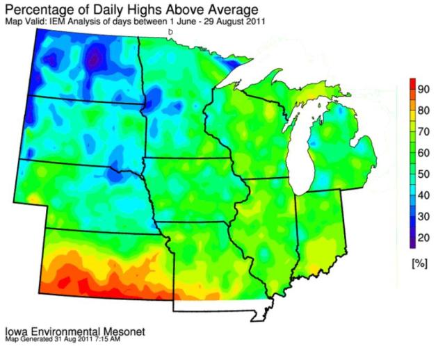
* Past 2 summers in Washington D.C. hottest since records began in 1871.
* 10,297 heat-related weather records in August, nationwide.
* 4,826 high temperature records last month, more than twice as many as August, 2010. (source: NOAA).
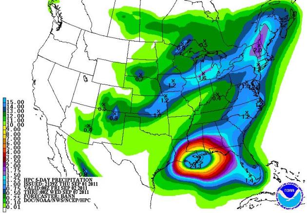
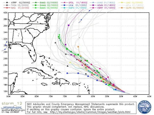
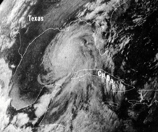
Another Historic Flood For New Orleans? Yes, that's a 24.3" bullseye of rain for the southern coastline of Louisiana. Irene showed us what a (mere) tropical storm is capable of - 10-20" rains capable of historic flooding inland. "Lee" will probably strengthen into a tropical storm, as early as today, and then meander in the Gulf of Mexico, stalling and spinning for 2-3 days, prolonging tropical rains for the Gulf Coast. The result may be some extreme 10-20" rains for much of Louisiana, southern Mississippi and Alabama by Sunday. If this forecast verifies (still a big if), flooding in parts of New Orleans could rival Hurricane Katrina in 2005. QPF outlook courtesy of NOAA's HPC division.
Lee's Projected Path. Lee may temporarily stall over the Gulf of Mexico today and Saturday, dumping tropical moisture onto the Gulf Coast, where flooding may be extreme. The soggy remains of Lee are forecast to drift into Alabama, where more flash flooding is possible early next week.
Discussion From Brett Campbell at Baron Services:
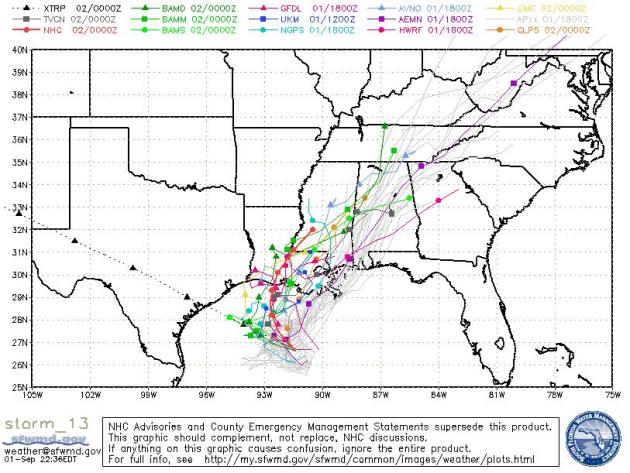
The BAMS model has been showing tropical development for the past few days in the central Gulf of Mexico also with other models to varying degrees. Development of this storm is expected to accrue slowly with little upper level support. Even as of 10pm this evening, organization is still weak but models to show an upper level ridge to build over the storm over the next 24 hours which should make TD #13 (at least) become Tropical Storm Lee.
Hurricane models are greatly spread with their solutions and NHC’s track to following closely to the SHIPS model. With TD #13(Lee) have little steering support for the next few days, movement is expected to drift to the north then northeast as the expected upper level ridge drifts off to the east and southeast.
The BAMS model has TD#13 moving slowly to the north then drifting around the Louisiana Gulf coast until late Sunday as the upper level ridge finally provides better steering. Other models also depict this such as the HWRF, GFDL and GFS. Was is to note is that even though this storms motion is questionable, the precipitation accumulations for the central Gulf Coast are huge.
The BAMS has been showing between 20 to nearly 25” of rainfall (22” at the 18z run) with the GFS not too far behind. HWRF is around at least 15” and NAM up 20”. These totals are through 84hours or into Monday morning. This cause major flooding concerns for New Orleans and low lying areas in the eastern areas of Lakes Pontchartrain and Maurepas. Even with tropical storm force winds, this should be enough to keep the water piling in to the west.
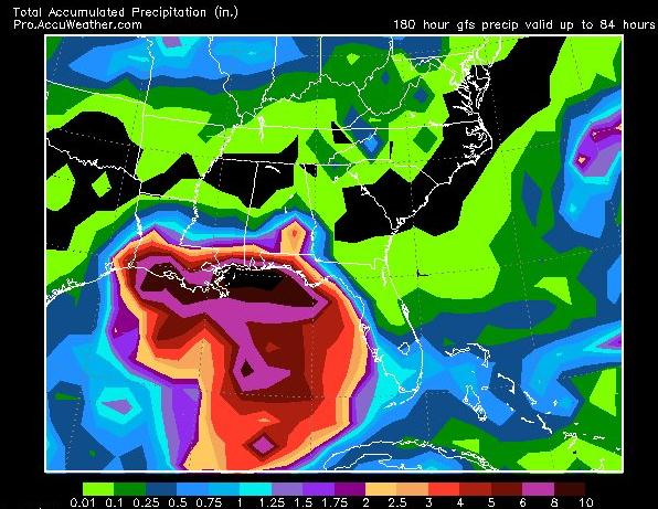
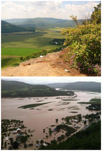

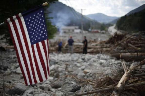
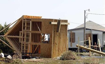
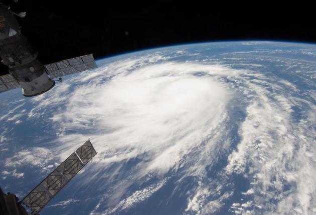
Photo Of The Day: Katia From Space. Check out this spectacular image of Hurricane Katia out in the mid-Atlantic, courtesy of NASA: "Katia was a tropical storm gathering energy over the Atlantic Ocean when one of the Expedition 28 crew took this photo on Aug. 31, 2011, from aboard the International Space Station. The picture, taken with a 12-mm focal length, was captured at 14:09:01 GMT. Later in the day Katia was upgraded to hurricane status. Two Russian spacecraft -- a Progress and a Soyuz --can be seen parked at the orbital outpost on the left side of the frame."
Katia: A Near-Miss. Hurricane Katia may strengthen into a Category 3 storm (120 mph sustained winds) before making a turn to the north, and then northeast. Prevailing westerlies should be strong enough to nudge Katia away from the northeast coast of the USA early next week.
RECORD EVENT REPORT
NATIONAL WEATHER SERVICE GLASGOW MT
0140 AM MDT THU SEP 01 2011
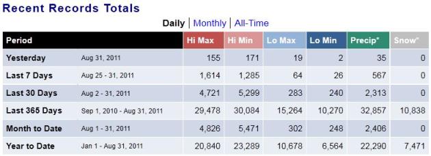
...RECORD CALENDARY YEAR MAXIMUM RAINFALL SET AT GLASGOW MT...A CALENDAR YEAR RECORD RAINFALL OF 21.00 INCHES WAS SET AT GLASGOW
MT YESTERDAY. THIS BREAKS THE OLD CALENDAR YEAR RECORD OF 20.73
INCHES SET IN 1938.


- LAS VEGAS NV -
RECORDS DATE TO 1937.
AUGUST 2011 WILL GO DOWN AS THE WARMEST AUGUST EVER IN LAS VEGASWITH AN AVERAGE TEMPERATURE OF 93.9 DEGREES. THE TOP 5 WARMEST
AUGUSTS IN LAS VEGAS ARE...
1. 93.9 DEGREES IN 2011
2. 93.1 DEGREES IN 1995
3. 93.0 DEGREES IN 2008
4. 92.9 DEGREES IN 1994
5. 92.5 DEGREES IN 2007
THE AVERAGE HIGH OF 105.8 RANKS AS THE 5TH WARMEST ON RECORD FOR
AUGUST. THE WARMEST EVER WAS 107.4 DEGREES IN 1937. THE AVERAGE LOW
OF 81.9 DEGREES RANKS AS THE WARMEST EVER FOR AUGUST...EDGING OUT
2008 WHEN THE AVERAGE LOW WAS 81.7 DEGREES.
THE AVERAGE TEMPERATURE IN AUGUST 2011 WILL ALSO RANK AS THE 8TH
WARMEST MONTH FOR ANY MONTH..
A Year's Worth Of Records. NCDC records show nearly 60,000 heat-related records since September 1, 2010 for the USA. That compares with over 25,000 low temperature records (daytime highs and nighttime lows) in the last year.

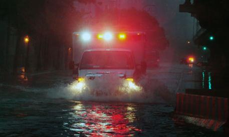
FEMA Faces Another Storm. The story from the Sun Sentinel: "Irene is gone, but the storm proved one thing: The nation's emergency response agency has made strides since its "heck-of-a-job-Brownie" days. Following last week's storm, the Federal Emergency Management Administration has drawn accolades from all quarters — a far cry from the criticism that followed Hurricane Katrina in 2005. Unfortunately, a different type of storm — this one brewing in the halls of Congress — threatens to undermine FEMA's work. Lawmakers spoiling for another budgetary brawl are putting FEMA in the untenable position of having to choose between decimated communities when providing dwindling post-disaster assistance. As a result, FEMA announced it won't consider new applications for permanent repair work in pre-Irene disaster zones, which now pits areas like tornado-whacked Joplin, Mo., against flood-weary Rutland, Vt. We understand the need for fiscal management. But there are duties where there should be absolute bipartisan agreement on the role of government, and this is one of them." (photo courtesy of floodpanel.com).


"Britons are notoriously obsessed with the weather, especially rainclouds. Now, according to scientists, it seems they will soon be able to create their own washout conditions. Using a powerful laser, researchers have created water droplets in the air. The technique, called laser-assisted water condensation, could one day unlock the secrets of weather cycles and enable humans to decide where and when it rains. While ‘cloud seeding’ has existed for some time it is not considered a safe way of creating rainclouds because it involves filling the atmosphere with small particles such as dry ice and silver iodide. This means that while raindrops can form, chemicals are often spread far and wide and potentially damage the environment."
Slice Of Life: We Ain't Seen Nothin'. Here's an interesting article from the Shelter Island Reporter: "Before 1950, hurricanes had no names. There might have been the odd storm that was labeled after an annoying politician or mythical beast, but for the most part they were just big storms. For example, the pacific cyclone “Yasi,” a real beast of a storm that struck the northeast of Australia last February, was named after the Fijian word for “sandalwood.” When they did start naming hurricanes, only women’s names were used. After almost 30 years of having their gender associated with ferocious natural disasters, the equal rights movement cried for justice and in 1979 Hurricane David became the first male hurricane. What I can’t figure out is why they don’t call male hurricanes himacanes, but never mind. One of the most violent hurricanes ever was Camille (sorry ladies) in 1969. This storm devastated the southeast with winds topping out at 190 mph. There are probably quite a few around here who remember that one, and there might even be some who remember the storm that took Long Island and New England by surprise in 1938. According to an excerpt from Everett Allen’s book, “A Wind to Shake the World” (Little, Brown, 1976), a yankee skipper had purchased a barometer and he couldn’t get the needle to budge off the bottom of the scale. Thinking it was defective, he took it back to the shop from where he had purchased it, and by the time he returned home his house had been washed into the sea. The magnitude of the storm was demonstrated by the discovery of papers from the town hall in Westhampton Beach, days later, in Vermont." (photo above courtesy of Wikipedia).
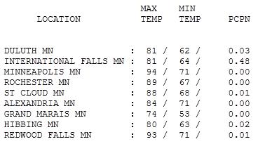
Steamy Thursday. A warm frontal boundary moved just north of the Twin Cities metro area, allowing the mercury to soar to 94 yesterday, 93 at Redwood Falls and 88 at St. Cloud. The Heat Index topped 100 at MSP by 3 pm.
Paul's Conservation Minnesota Outlook for the Twin Cities and all of Minnesota:
TODAY: A few AM showers, PM clearing, turning breezy and less humid. Dew point: 64. Winds: NW 10-20. High: 75
FRIDAY NIGHT: Clearing skies, more comfortable. Low: 58
SATURDAY: Partly sunny, less humid. Slight chance of a PM shower. Winds W 10-15. Dew point: 56. High: 77
SUNDAY: Partly sunny, breezy and cool. DP: 48. Low: 55. High: 68
LABOR DAY: Best day of the weekend? Bright sun. Light winds. Winds: SE 5-10. Low: 50. High: 72.
TUESDAY: Lot's of sunshine, lukewarm. Low: 56. High: 74
WEDNESDAY: Less sun, PM shower? Low: 58. High: 76
THURSDAY: Blue sky returns, very pleasant. Low: 59. High: 75

Photo courtesy of ABC News.
Weather-On-A-Stick
I had a chance to visit with some amazing Minnesotans at the Star Tribune booth, out at the Great Minnesota Sweat-Together, Wednesday evening. Note to self: check out the ketchup-flavored lip balm and amazing selection of T-shirts).
One fair-goer asked, "Paul, it's been a steamy summer - might that increase the odds of a milder winter?" Don't I wish. There is no scientific correlation between summer weather and what unfolds the following winter. My bootleg copy of the new Farmer's Almanac is warning of another "wild winter", but here's the deal: the odds of another winter with 86.6" snow in the metro area are slim. There's no strong La Nina cooling of the Pacific, which could tip us over into a colder, snowier pattern.
Meanwhile "Lee" may strengthen to tropical storm status; a few models have a meandering hurricane off the coast of Texas by Saturday morning. Some 8-12" rainfall amounts are possible along the Gulf coast.
A cooler front whips into town today with showers and temperatures falling thru the 70s. The weekend feels like September, a few instability showers possible late Saturday, mainly up north. It gets sunnier Sunday PM into Labor Day, the best day in sight!
Can Climate Change Cause Mental Illness? Not sure about this one, but in the spirit of full disclosure, here's a story in the International Business Times: "As climate change and its impacts on our planet and society are still debated, a new report by the Climate Institute of Australia warns against the devastating effects of extreme weather events on communities' mental health.aking severe weather events in Australia as a point of focus for the study, the report also blames adverse weather on climate change and says: "Unabated, a more hostile climate will spell a substantial rise in the incidence of post-traumatic stress, anxiety and depression - all at great personal suffering and, consequently, social and economic cost." The document, published this week, also warns that up to 20% of affected communities will suffer extremes stress, emotional injury, anxiety, depression, post-traumatic stress and substance abuse. The study found that as severe weather events in Australia increase in number, "climate change will have many adverse impacts on Australians' health - physical risks, infectious diseases, heat-related ill effects, food safety and nutritional risks, mental health problems and premature deaths."
No comments:
Post a Comment