70 F. high in the Twin Cities Monday (trace of rain reported).
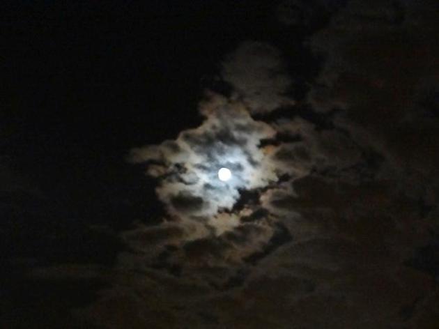
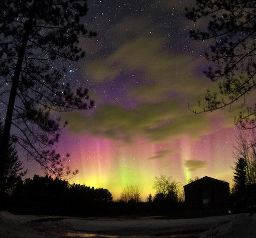
Aurora Borealis may be visible in the coming nights (see story below).
36 F. coolest temperature so far in the metro area (September 15).
.31" rain has fallen on MSP so far this month (2.29" drier than average, to date).
Paul's Conservation Minnesota Outlook for the Twin Cities and all of Minnesota:
TODAY: Cool, unsettled, periods of rain expected. Winds: N 10-15. High: 65
TUESDAY NIGHT: Mostly cloudy with a few leftover showers. Low: 57
WEDNESDAY: Damp start, then lukewarm sun, drier and nicer. High: 75
THURSDAY: Partly sunny and windy (cool front should come through dry). Low: 58. High: near 70
FRIDAY: Blue sky, less wind. Low: 45. High: 62
SATURDAY: Plenty of sun, quite pleasant. Low: 46. High: 65
SUNDAY: Indian Summer, get outside! Low: 50. High: 71 (mid 70s over southern Minnesota)
MONDAY: Still mild, high clouds dim sun. Low: 53. High: near 70
GEOMAGNETIC STORM:
A strong geomagnetic storm is in progress following the impact of a coronal mass ejection (CME) today, Sept. 26th, at approximately 12:15 UT.
Analysts at the Goddard Space Weather Lab report a "strong compression of Earth's magnetosphere" and the possibility that satellites in geosynchronous orbit have been exposed to solar wind plasma and magnetic fields. Mid- to high-latitude sky watchers should be alert for auroras after nightfall. Observing tip: The hours around local midnight are usually best for spotting Northern and Southern Lights. Check
http://spaceweather.com for images and updates.
The
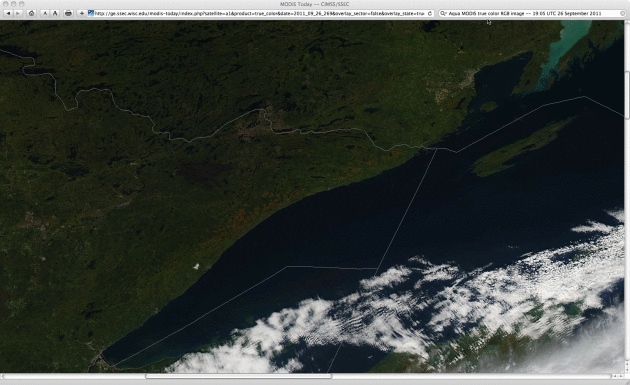
Pagami Creek Fire is 53% contained, and according to the Public Information Officer, fire crews have constructed lines all around the fire, and have begun putting out hot spots that pop up in the underbrush. He said also that the weather has been helping with light breezes and better conditions for people fighting the fire. The NASA "MODIS" image above shows the roughly 10% of the BWCA that has been scorched by the Pagami Creek blaze - the other image is a "true color" photo showing ripening leaves along Lake Superior's North Shore.
Sunday, the Indianapolis airport recorded
2.17″ of rain, breaking the previous one day total of 2.13 set back in 1961.
Central Park, New York City: 9th Wettest Year with
58.44". Records go back to 1869
"...
Our results demonstrate that the dominant personality types for Ph.D. climate change researchers are fundamentally different from those found in the U.S. population. This suggests that there is a strong potential for inherent challenges in communication between these two groups." - from a Capital Weather Gang story about the inherent challenges in communicating climate science.
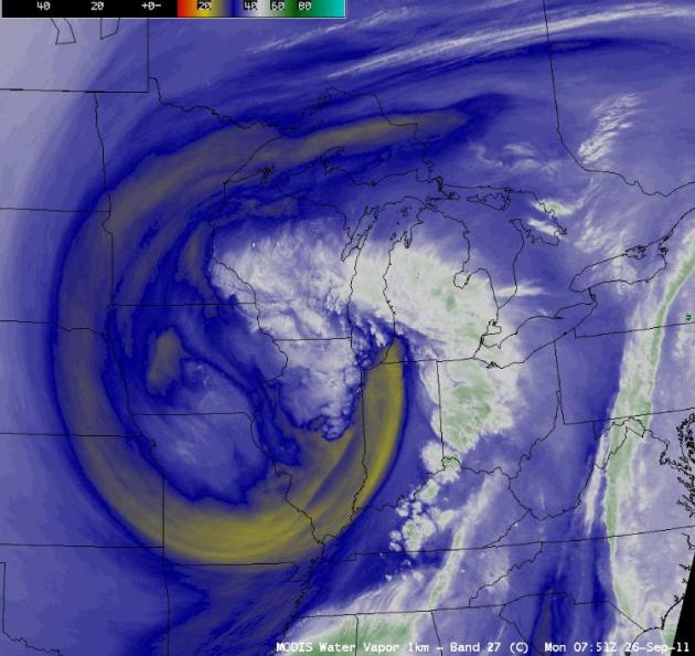 Stormy Swirl.
 The "cut off" low pressure system centered near the Quad Cities of Iowa is impacting weather from Minnesota to Indiana, southward to Missouri. Under the center of this counterclockwise-rotating swirl of chilly air in the upper atmosphere skies are unstable - capable of showers (especially PM hours). A few showers may wobble into the Twin Cities metro area today; once again the best chance of rain south/east of the Twin Cities.
 This Weekend: Indian Summer
. There's little doubt we'll warm into the 60s Saturday, possibly the 70s on Sunday, thanks to a ridge of high pressure over the Plains and Upper Midwest. You will want to spend some serious time outdoors this weekend.
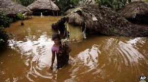
Over 2 Million Impacted By Indian Floods. The
BBC has an update: "
Heavy monsoon rains have been battering parts of India for the past fortnight. More than 80 people have died in flood-related incidents, and some areas have been cut off by rising waters. Heavy rains in Uttar Pradesh (UP) have killed more than 30 people across the state. A flood alert has been issued in eight districts in Bihar. In Orissa, the worst affected state, vast parts of 10 districts have been inundated by flood waters, officials say. Special Relief Commissioner PK Mohapatra said 55 people had died - some drowned, while others died from snakebites and in wall collapses. More than 10 people who had gone missing after the boat in which they were travelling overturned in the Brahmani river in Dhenkanal district were rescued on Monday, officials say. Some areas have been cut off because of breaches to river banks and embankments. Helicopters are the only way to bring food and water to people stranded there."
Raw Video: Inside D.C. Monument During Quake. Click
here to see some remarkable video, courtesy of AP and YouTube: "
The National Park Service released surveillance video that captured the moment an earthquake shook the Washington Monument. The 5.8-magnitude quake in August caused several cracks to form at the top of the 555-foot structure."
 Unsettled Monday
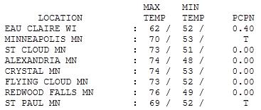
. The sun was out over central and western Minnesota (highs soared into the mid 70s), while sprinkels and showers (and clouds much of the day) kept temperatures cooler east of the Twin Cities. Highs ranged from 76 at Redwood Falls to 73 in St. Cloud, 69 at St. Paul and a rainy 62 at Eau Claire, Wisconsin.
More Sneezing?
According to The Atlantic the number of asthma sufferers in the U.S. has doubled since 1980. Early springs and warmer autumns mean the asthma and allergy season is 2-4 weeks longer in Minnesota. More carbon dioxide and more warming produces more pollen in the spring and ragweed in the fall.
The frost/freeze in mid September killed off a fair amount of ragweed across greater Minnesota, but allergies will be a factor until the first widespread, statewide (hard) freeze, which is still probably 2+ weeks away.
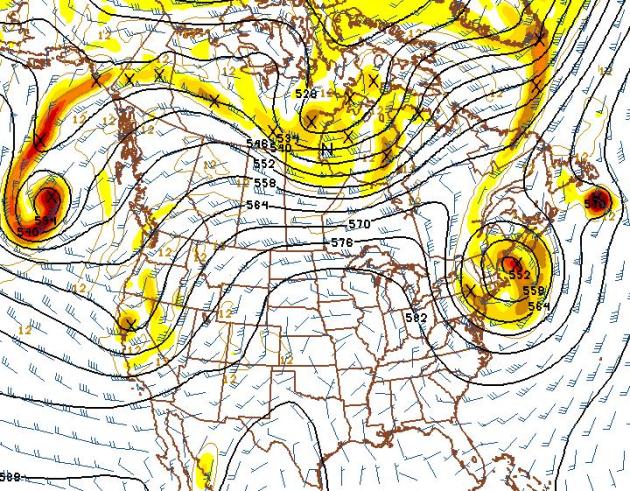
The morning weather map looks a bit surreal: spiral bands showing up on Doppler radar, approaching from the northeast! A cold puddle of air aloft centered near Chicago sparks a few hours of showers today - as weather systems remain stuck in an odd holding pattern. Good news: 70s return tomorrow, followed by a fleeting cool front on Thursday. Winds ease up on Friday, a gradual warming trend spilling over into the weekend (highs near 70 by Sunday). Sunshine should be the rule into early next week, temperatures at or above normal into the 1st week of October. Long range guidance suggests a (much) cooler front after October 10 or so. Until then, enjoy the weather honeymoon!
Newsflash: Climate Scientists Are Different Than The General Public. It's a communications challenge, and the Washington Post's
Capital Weather Gang does a good job of explaining the potential disconnect between Phd climate scientists and the general public: "
As someone who writes about climate change and weather for a living, I think a lot about the many barriers to accurately communicating complicated scientific topics to general audiences. With climate change, there are so many pitfalls to communicating in a way that truly connects with people that sometimes it almost seems like a lost cause. Study after study and poll after poll have shown that there is a huge discrepancy between the widespread agreement within the scientific community that the earth is warming in large part due to human activities, and the prevailing public view of the situation, which is far more skeptical about what is causing the climate to warm, or even whether it is warming at all. A new study published in the journal Climatic Change examines one barrier to effective climate science communication that I previously never considered before, but that now seems totally obvious. The paper identifies personality type differences between Ph.D. climate researchers and the general public, and (shocker!) finds that most climate researchers process information and make decisions based on that information very differently than the general public. “Our results demonstrate that the dominant personality types for Ph.D. climate change researchers are fundamentally different from those found in the U.S. population. This suggests that there is a strong potential for inherent challenges in communication between these two groups,” the study states."
Health And Climate Change: 7 Ways You Are Being Harmed. The story from
The Atlantic: "
The consequences of climate change sometimes appear far off. But warming and changing weather patterns are already driving changes in public health. The following are seven ways in which climate change affects you and your well-being.
Heatwaves
Heatwaves are increasing in frequency, intensity, and duration throughout the world. The nature of heatwaves is also affected by climate change. Nighttime temperatures have been climbing twice as fast as average temperatures since 1970, meaning less relief at night. (When the temperatures at night don't fall in farm country, the cows go down. The same holds true for us.) In addition, the warmer atmosphere holds more water vapor -- seven percent more for each one-degree Celsius warming -- raising humidity levels, thus heat indices, which determine how we feel during a heatwave. The combination of factors make heatwaves today all the more lethal, and the consequences include cardiorespiratory illness, and dehydration and diarrhea in children. Thousands have lost their lives in recent heatwaves in Europe, Russia, and India, for example.
Asthma and Allergies
The total number of asthma sufferers in the U.S. has more than doubled since 1980 and several exacerbating factors stem from burning fossil fuels."
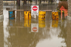
A Record Year For Disasters - And Promises Of Federal Help. The story from
stateline.org: "
Last week, when President Obama named New Jersey a federal disaster area for floods that came before Hurricane Irene, he cemented 2011’s ranking as the United States’ most disaster-prone year ever. Through the third week of September, Obama had issued 84 federal disaster declarations at the request of governors. That is more declarations than in any year since the score was first kept six decades ago. And there are still three months left in 2011. Much of the reason for this year’s record, of course, is bad weather. Damage included virtually unheard of cold spells in Oklahoma, dozens of tornadoes in Alabama, rising rivers threatening towns throughout the Midwest, drought-fueled wildfires in Texas and Hurricane Irene, which soaked nearly the entire Eastern seaboard. Still, bad weather does not tell the whole story. Scholars and experts suggest many other reasons for the recent surge: Suburban sprawl is pushing people into more places, increasing the likelihood that storms will hit populated areas. A larger share of the population now lives closer to the coasts than a generation ago, increasing the damage when a hurricane comes ashore. Global warming may even play a role."


No comments:
Post a Comment