67 F. high in the Twin Cities Tuesday (.05" of rain fell in the metro area).
81 F. high in Redwood Falls yesterday. Low to mid 80s are likely over southwestern MN later today.
The
BWCA fire is now almost 60% contained with 93,469 acres burned. No anticipated date of containment has been released, but the fire is surrounded, and conditions are favorable for fire teams to continue working.
There is an
Air Pollution Advisory out for the Dallas/Fort Worth area, prompting a warning for sensitive groups. This includes people with asthma and emphysema, along with young children and the elderly.
San Angelo hit 100 degrees at 1:02 PM CDT Tuesday, making today the 100th day of triple digit temperatures in 2011.
Record rainfall amounts were recorded in Indianapolis, IN, Dayton, OH, and Rockford, IL. Over three inches of rain was recorded in each location.

* The United States experienced it’s
second warmest summer on record, with an average of 3 degrees above normal. The only warmer summer was in 1936, which was at the height of the Dust Bowl.
 "...Take sea-level rise. Just fortifying the lower 48 states against a three-foot hike in ocean levels by century’s end could cost more than $1 trillion, according to the EPA’s sea-level experts (and that doesn’t include the indirect costs of destroying huge swathes of U.S. coastal wetlands with concrete sea barriers)
." - from a Washington Post article focused on which countries are most vulnerable to climate change.
"...
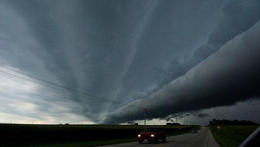
The U.S. has had more than its share of bad weather (and it doesn't seem to let up). The record-breaking, tornado-packed storm system that hit a dozen states this past spring killed over 300. The southwest has been in drought and aquifers, already overdrawn and underfed, were further challenged by summer dry spells and heatwaves. In April, 83 wildfires consumed hundreds of square miles of Texas in one week. Extreme weather has reduced grain yields in the Southeast and in the Midwest Corn Belt." - story on the true cost of carbon in The Atlantic (below).
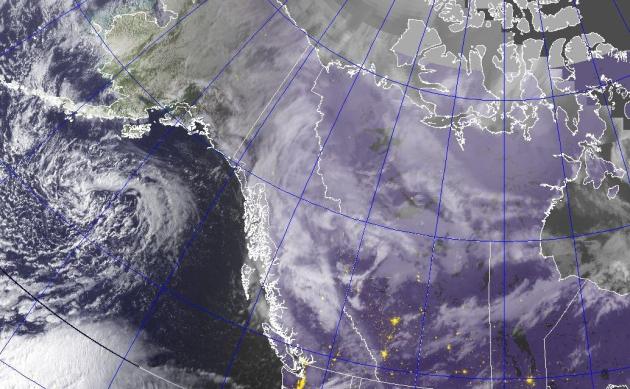
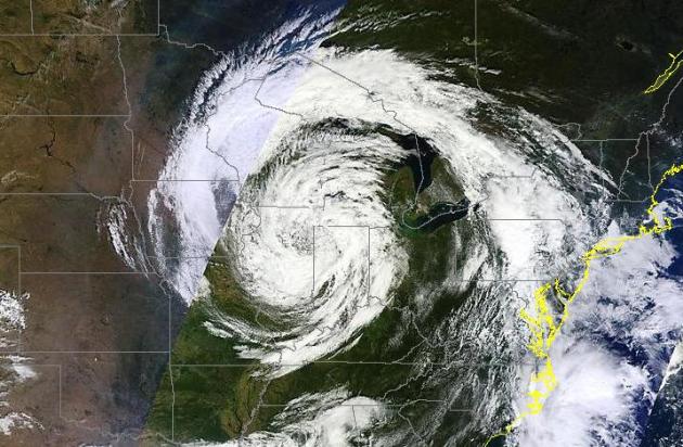 "Weather Monster".
 With spiral bands rotating into the center of a nearly stationary low pressure system (a "landicane"!) the "cut off low" sparked showery rains over the Twin Cities and southeastern Minnesota, while much of central and western Minnesota enjoyed a beautiful day with highs in the mid 70s to near 80.
* Click
here for an amazing animation of the closed low that has tormented the Great Lakes and Upper Midwest for the better part of 5 days, sparking waterspouts over Lake Michigan and some 5-7" rains over Ohio, courtesy of the U. of Wisconsin.
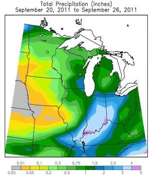 Extreme Rainfall Amounts
. The stalled storm over the Great Lakes has squeezed out some 3-6" rainfall amounts over Indiana, Ohio and Kentucky since September 20.
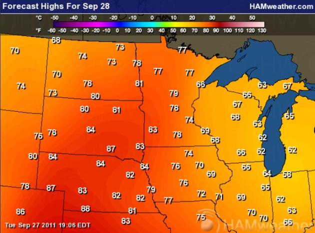 Just About Perfect
. After wrestling with the outer bands of a stalled storm near Chicago the sun will be out (statewide) today, highs ranging from the mid 70s in the Twin Cities metro to low/mid 80s over southwestern Minnesota. Yep, air conditioners may click on for a few hours later today. Map courtesy of
Ham Weather.
NASA Warns Of Geomagnetic Storm After Behemoth Solar Flare. An update from
networkworld.com: "
NASA today said a strong-to-severe geomagnetic storm is in progress following a massive solar flare and coronal mass ejection (CME). CMEs are a solar phenomenon that can send solar particles into space and affect electronic systems in satellites and on Earth. Simulations indicate that solar wind plasma has penetrated close to geosynchronous orbit starting at 9am today. Geosynchronous satellites could therefore be directly exposed to solar wind plasma and magnetic fields. High-latitude sky watchers should be alert for auroras after nightfall, NASA stated. The National Oceanic and Atmospheric Administration's Space Weather forecast center went further saying: A CME that erupted from NOAA Active Region 1302 on Saturday September 24 in conjunction with an M7 strength solar flare, arrived this morning at 1237 UT (8:37am Eastern Time). It has kicked off moderate (G2) geomagnetic storms for low latitudes, but high latitudes are seeing severe (G4) levels of activity. Aurora watchers in Asia and Europe are most favorably positioned for this event, though it may persist long enough for viewers in North America. The bulk of the CME missed the Earth, meaning the storm intensity and duration are less than what they would have been in the case of a direct hit. Region 1302 remains capable of producing more activity and will be in a favorable position for that activity to have impacts on Earth for the next 3-5 days."
 Former Typhoon Roke Deals British Columbia An Early Fall Lashing
. Although no longer a hurricane/typhoon, the soggy remains of Roke (which struck southern Japan as a Category 3 storm a week ago) is spiking the rain and wind over far western Canada.
AccuWeather reports: "
Rain and strong winds persisted along Canada's west coast on Tuesday as a powerful storm slowly waned. The storm, which was formerly Typhoon Roke when over the western Pacific, unleash high winds and heavy rain as it approached the west coast on Monday. The storm caused widespread power outages and aggravated already high water on streams and rivers, as it came on the heels of recent excessive rainfall and flooding. Some ferry sailings, such as those linking Vancouver with the provincial capital of Victoria, were scrubbed, causing traffic backups. Upwards of 20,000 electrical customers in northern Vancouver Island lost power, according to CBC News. Thousands more elsewhere on the island and the mainland also suffered outages. Winds at Solander Island, off the north shore of Vancouver Island, reached as high as 105 mph (169 km/hr) on Monday. Hurricane gusts were registered elsewhere along BC's northern coast."
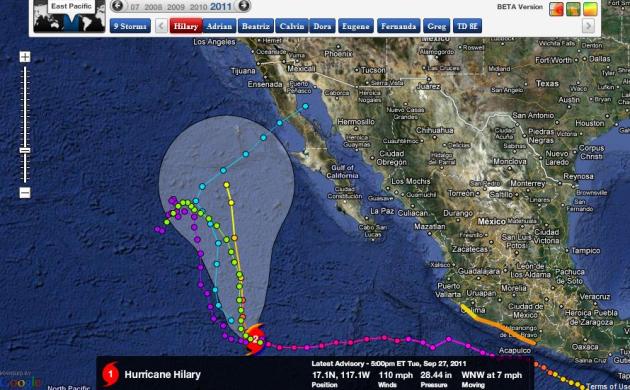 Hurricane Hilary
. Downgraded to a Category 1 hurricane, Hilary is forecast to take a northerly turn, possibly curving toward Baja Mexico by early next week. A few long-range computer models bring the soggy remains of Hilary into Arizona or New Mexico next week.
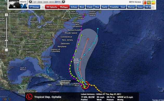 Tropical Reincarnation
. Ophelia has weakened into a tropical depression east of Puerto Rico. According to NHC there is a high probability (greater than 80%) that this depression will restrengthen into a tropical storm in the next 48 hours, and then accelerate northward, possibly hitting Nova Scotia, Canada as a minimal, category 1 hurricane by Monday of next week.
The Disaster-Stricken Cluck Tongues At Congress. Yes, nothing says class and effectiveness more than a Congress willing and ready to play politics and withhold payments from disaster survivors. The
Associated Press has the story: "
WATERBURY, Vt. (AP) — For disaster victims rebuilding their homes, towns and lives, the anxiety is matched only by anger at Congress for entangling their future in a political battle over government spending. A sharply divided Congress had repeatedly rejected a deal that included funding federal disaster assistance, raising fears that there would be no plan to continue aid for victims of disaster like storms Irene and Lee or the tornado in Joplin, Mo. On Monday, Congress advanced legislation to assure there would be no interruption in assistance through the new budget year, which begins Saturday. But that didn't do much to appease those who would have paid perhaps the highest price for politics. They're spreading the blame both among Republicans, who want cuts in other government spending, and Democrats, who are accused of using the GOP opposition to win political points. "They aren't looking so much at what is actually needed as what's good for their party, and that to me is wrong, wrong, wrong," said Lawrence Sayah, a Waterbury resident whose home, ravaged by the floods wrought by the remnants of Hurricane Irene, is still stripped to the studs inside."
Tornado Warning Signs. Here's some good information from the
Mother Nature Network: “
The most violent tornadoes can level and blow away almost any house and its occupants,” the NOAA reports. “Extremely violent F5 tornadoes are very rare, though. Most tornadoes are actually much weaker and can be survived. "Taking precautions means understanding tornado warning signs. How many of us know blue-green flashes on the ground near a thunderstorm mean power lines are being snapped by very strong winds, indicating a possible tornado? Or that many tornadoes are wrapped in so much heavy precipitation or hail they can’t be seen? Those are among the warning signs listed by the NOAA/NWS storm prediction center.
Here are 10 less familiar warning signs and tips for preparing once a tornado is imminent:
-
Know the difference between a tornado watch and a warning. A watch means tornadoes are possible in and near the watch area, the Red Cross reports. A warning means a tornado has been sighted or indicated by weather radar. Take shelter immediately.
-
Review and discuss your emergency plans with your family and check supplies, including non-perishable food, water, flashlights, batteries and a weather radio.
-
Prepare to head to a reinforced safe room, basement, storm cellar or interior space — closet, hallway or bathroom — on the lowest level of your home away from windows.
-
Look for dark, often greenish clouds, a reflection of ice and water or hail, that might form a wall or isolated lowering at the base of a thunderstorm.
-
Be aware of hail or heavy rain followed by either dead calm or a fast, intense wind shift.
Kids: An Important Part Of A Family Disaster Plan.
FEMA has some useful advice here: "
Helping their parents assemble an emergency kit is an ideal activity for children. (visit http://www.ready.gov/kids/step1/index.html) Explain to kids that families like yours may need to survive on their own for a little while after an emergency. This means having food, water, and other supplies to last three days.
Recommended items to include in a family emergency kit or ‘Go Bag’:
- One gallon of water per person per day for at least three days, for drinking and sanitation
- A three-day supply of non-perishable food
- Battery-powered AM/FM radio and/or a NOAA Weather Radio receiver
- Flashlight and extra batteries
- First aid kit and whistle
- A dust mask, plastic sheeting and duct tape
- Moist towelettes, garbage bags and plastic ties
- Wrench, pliers, matches and can opener
- Local maps
- Cellphones with chargers, inverter or solar charger
Scientists Look To Indian Ocean For Long Range Weather Forecast. Here's an interesting story from the
International Business Times: "
Scientists from 16 countries will converge in the Indian Ocean next month and pool their resources to conduct a six-month field study on how tropical weather developed in that ocean affects weather patterns in other parts of the world. The international team plans to use aircrafts, ships, moorings, radars, numerical models and other tools to determine how weather systems in the Indian Ocean move eastward along the equator and then proceed further around the globe. Scientists said the goal of their work is to get a better understanding of a phenomenon in the tropics that is known as the Madden-Julian Oscillation (MJO). This disturbance begins in the equatorial Indian Ocean every 30 to 90 days and it is part of the Asian and Australian monsoon."
A Way To Make Motor Fuel Out Of Wood? Add Water. Some potentially amazing breakthroughs on the ethanol front, as reported by the
New York Times: "
A Georgia company says it has overcome a major roadblock in turning agricultural waste into vehicle fuel and other useful chemicals by experimenting with a technology that treats the waste with compressed water heated to very high temperatures. The company, Renmatix, plans to cut the ribbon on a research and development center on Tuesday in King of Prussia, Pa., near the heart of the nation’s chemical and refining industry, to complete development of the process. The goal is to accomplish something that has eluded a dozen companies in recent years despite big government inducements: to commercialize a technology for making use of cellulosic biomass, or wood chips, switchgrass and the nonedible parts of crops. If it works, the technology could reduce the nation’s reliance on oil imports for gasoline in favor of a cleaner-burning and less expensive source of energy. A company with a workable technology would have a guaranteed market, given that Congress has set quotas for the consumption of cellulosic fuel but so far, hardly any is being produced."
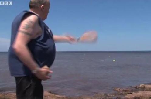
Man Throws 4,800 Bottles With Messages Out To Sea, Gets 3,100 Replies. Those are pretty good odds, all things considered. Details from
neatorama.com: "
Harold Hackett of Prince Edward Island, Canada, does what the BBC calls “old-school social networking.” Since 1996, he’s tossed 4,800 bottles into the sea. The currents have carried some of them to Europe, Africa, the United States, and Caribbean islands. He knows this because he’s received more than 3,100 letters from people, many of whom share their inner thoughts with this stranger from across the ocean. Watch the video at the link about Hackett’s story."
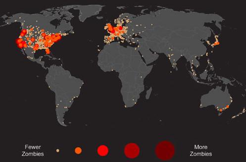
Where Are The World's Zombies? I had no idea.
Neatorama.com has the details: "
Where in the world are zombies? Oxford Internet Institute researchers Mark Graham (of Floating Sheep's fame), Taylor Shelton, Matthew Zook, and Monica Stephens mapped the world's zombie outbreaks:
Using a keyword search for "zombies," the following map visualizes the absolute concentrations of references within the Google Maps database. The map reveals two important spatial patterns. First, much of the world lacks any content mentioning "zombies" whatsoever. Second, and related, the highest concentration of zombies in the Geoweb are located in the Anglophone world, especially in large cities. The results either provide a rough proxy for the amount of English-language content indexed over our planet, or offer an early warning into the geographies of the impending zombie apocalypse."
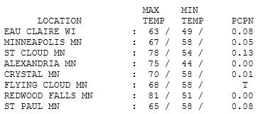
Partly Amazing. While a tangle of clouds and showers kept far eastern Minnesota cool and foul, the sun was out over central and western Minnesota. St. Cloud reported 78, with 81 at Redwood Falls. That 70-degree air will sweep across all of Minnesota today.
 Paul's Conservation Minnesota Outlook for the Twin Cities and all of Minnesota:
TODAY: Blue sky, beautiful. Winds: NW 3-8. High: 77
WEDNESDAY NIGHT: Clear and pleasant. Low: 58
THURSDAY: Windy and cooler with a mix of clouds and sun. NW 20-30. High: 67
FRIDAY: Bright sun, winds subside. Low: 47. High: 61
SATURDAY: Sunny and spectacular. Low: 46. High: 68
SUNDAY: Mild sun, Indian Summer returns! Low: 52. High: 71
MONDAY: Not bad for early October. Dim sun, still balmy. Low: 55. High: 73
TUESDAY: Stray shower possible, turning slightly cooler. Low: 54. High: 68

A Fine Fall Day
"Weather is a great metaphor for life - sometimes it's good, sometimes it's bad, and there's nothing much you can do about it but carry an umbrella", wrote Terri Guillemets. Very true.
America is the "Superbowl of Weather" (more severe weather - consistently - than any other nation on Earth), and Minnesota and North Dakota are virtually tied for the most weather extremes in the USA. So when a day like today comes along (meteorologists optional) Minnesotans soak up the blue sky and give thanks.
Technically, unusually mild weather isn't "Indian Summer" until after the first frost. The MSP metro cooled down to 36 on September 15, but no official frost yet for the close-in suburbs or downtowns. Frost-free weather should linger into the first week of October.
Blue sky lures the mercury into the 75-80 range today before a clipper pulls cooler air south on Thursday, gusty northwest winds topping 30 mph.
A slow warming trend returns for the weekend, 70 by Sunday/Monday. Not bad for early October.
It's human nature to obsess on the unknowable. "What will the winter be like, Paul?" I wish I knew. Actually it's better I don't know. Like everyone else I'll take it 1 day at a time.
Food Security And Climate Change: The True Cost Of Carbon. Here's a must-read article from
The Atlantic: "
Writing on page one in the New York Times Justin Gillis recently sounded the alarm on what Lester Brown has been warning us for years: Climate change is threatening our food supply. With fuel prices down (not much) we'd like to think the economy will settle down. But volatility in markets, food baskets, and weather are rattling many. Indeed, food, feed, and fuel prices are contributing to the growing political instability across the globe. The summer heat engulfed towns felled by fiendish twisters. The Mighty Mississippi breached shores all along its course after being pounded by heavy rains and nourished by melting snow, the hangover from a brutal winter. The hundred-year floods inundated homes, homesteads, and farms, taking a toll on communities and commodities. The wide swings in weather were matched by major outlier events. All of us experienced the shifting weather patterns. This is the new norm. And as the climate changes, the extremes are proving especially costly for global food security. Grains are taking a particular beating. In the past year, wheat prices increased 75 percent. In 2009, the United Nations estimates, over one billion people were undernourished, and a greater toll is projected. Malnutrition -- accounting annually for 2.2 million under-five child deaths (and underlying much of childhood illness) -- is increasing, undermining health and well-being."
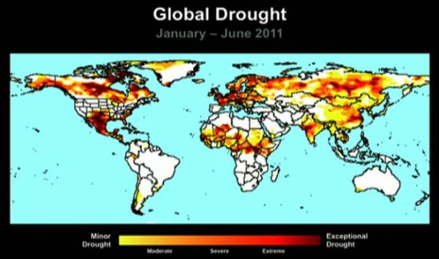
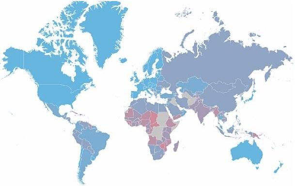
Which Countries Will Get Hit Hardest By Climate Change? From an article at the
Washington Post: "
The Global Adaptation Institute has put out its annual index showing which countries will likely suffer most from global warming. Light-blue countries, like Canada and Denmark, are relatively well-positioned to adapt to a hotter climate (though the key word there is “relatively”). Nations in red and purple, like Bangladesh or Mali, don’t fare so well. Countries in gray, like Russia and China, fall somewhere in the middle.
In constructing the index, GAI looked at two factors. First, there’s vulnerability. How much will a country be materially affected by sharp shifts in precipitation, by droughts, by heat waves, by rising sea levels, and so forth? The second factor is adaptability: Does the country have the resources to deal with adverse consequences? Not surprisingly, richer countries do much better on this score. Heat waves, for instance, kill fewer people when there’s modern public-health infrastructure in place."
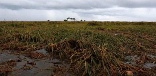
Climate Change And The Exodus Of Species. An Op-Ed from the
New York Times: "
To most humans, so far, climate change is still more of an idea than an experience. For other species, it is an immediate reality. Many will be left behind as the climate alters, unable to move quickly enough or with nowhere to move to. Others are already adapting. An iconic example of these swift changes is the recent discovery that Atlantic and Pacific populations of bowhead whales — long kept apart by the frozen Arctic — are now overlapping in the open waters of the Northwest Passage. A team of scientists from the University of York examined the movement of 2,000 animal and plant species over the past decade. According to their study, published in Science last month, in their exodus from increasing heat, species have moved, on average, 13.3 yards higher in altitude — twice the predicted rate — and 11 miles higher in latitude — three times faster than expected. These changes have happened most rapidly where the climate has warmed the most." (photo above courtesy of
MSN).
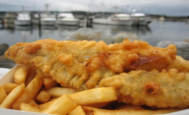
The End Of Fish And Chips: Climate Change Causing Massive Changes In European Fisheries.
Fast Company has the story: "
There may be nothing new under the sun, but beneath the sea is a different story. Scientists studying 28 years of data from the Atlantic Ocean have found that climate change is causing drastic changes in fish populations off the European coast--and that's bad news for cold-loving species like cod, which have fed generations of Northern Europeans. The North Sea, a cold wind-swept patch of the Atlantic stretching from Scandinavia to the U.K., is warming four times faster than the global average. During the last 30 years, the roughly 2°F increase in mean annual temperature (the North Sea swings between 63°F and 43°F during the summer and winter) has had a profound influence on fish growth and survival, egg maturation, and the plankton supporting food webs and commercial fisheries. British scientists analyzed 11 surveys, covering at least a million square kilometers of the European continental shelf, and more than 100 million fish, "to get the 'big picture' of how warming is affecting fish communities," according to Stephen Simpson of the University of Bristol, whose research appears in a recent issue of Current Biology. They found that 72% of common fish species had responded to rising sea temperatures. Most species--three out of four--were growing more abundant, and hake and dab had doubled, while catches of cold-loving species, including haddock and cod, dropped by half."
Moving Planet Rally Shows Diversity In Minnesota's Climate Change Movement. The story from the
Twin Cities Daily Planet: "
Meet with your elected representatives, ride a bike, talk to your neighbors, listen to the youth, buy local, send Obama a letter, learn to cook vegetables, find centeredness — these are just a few of the messages conveyed by presenters and organizations present at the September 24 Moving Planet climate change rally in front of the state capitol. According to a rally organizer from MN350, around 1000 people showed up to “move beyond fossil fuels.” The rally was the Twin Cities’ response to an international call to action made by 350.org, a climate change organization co-founded by writer and activist Bill McKibben."


No comments:
Post a Comment