75 F. high in the Twin Cities Monday. Normal high is 70.
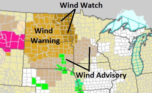
Wind Advisory posted today.
40 mph wind gusts possible by afternoon, evening.
50s Wednesday - a definite taste of October in the air with windchill readings in the 40s.
70s return next weekend (80 possible Sunday, especially western Minnesota).
A Very Bad Hair Day. Wind advisories are posted for much of central Minnesota (including St. Cloud and the Twin Cities) for winds gusting over 40 mph later today. Some 50 mph + wind gusts are possible over far western Minnesota, closer to the Dakota border. Map courtesy of the National Weather Service. More details:
...STRONG WINDS DEVELOPING TUESDAY BEHIND A COLD FRONT...
.A WIND ADVISORY REMAINS IN EFFECT FOR MUCH OF CENTRAL AND SOUTHERN MINNESOTA FOR TUESDAY. THE ADVISORY BEGINS AT 10 AM.
SOME LOCATIONS IN THE ADVISORY INCLUDE ALEXANDRIA...ST. CLOUD...
GRANITE FALLS...REDWOOD FALLS...NEW ULM...AND THE TWIN CITIES METROPOLITAN AREA.
VERY STRONG WEST WINDS WILL DEVELOP TUESDAY MORNING IN THE WAKE OF A COLD FRONT. BY TUESDAY AFTERNOON...SUSTAINED WINDS ARE EXPECTED TO BE BETWEEN 25 AND 35 MPH WITH GUSTS TO 45 MPH. A FEW WIND GUSTS COULD TOP 50 MPH IN THE MORRIS...APPLETON...MADISON AND CANBY AREAS OF WEST CENTRAL MINNESOTA.
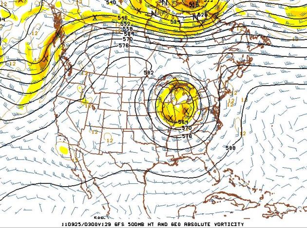
Small Fly In The Weather Ointment. Long-range guidance (valid Saturday night) shows a closed low, a "cut-off" low pressure system over Illinois and Indiana. It's possible this cold swirl aloft may spark patchy clouds as close as Iowa, Wisconsin, even southeastern Minnesota Sunday-Monday. Too early to say, but the mildest weather (70s and low 80s) will probably pop up across the Dakotas and far western Minnesota - cooler/cloudier conditions the farther east you travel into Wisconsin.
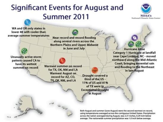
A Summer To Remember. 10 separate billion dollar weather disasters so far in 2011 - most on record for the United States. How firm is the link between climate change and an (apparent) increase in the frequency and intensity of extreme weather events? The Capital Weather Gang has the story below.
Number of 100 Degree Days:
95 Wichita Falls, Texas (old record was 79 days)
93 San Angelo, Texas (old record was 60 days)
79 Waco, Texas (old record was 63 days)
76 Austin, Texas (old record was 69 days)
41 Houston, Texas (old record was 62 days)
Misty Rain Relieves Burning BWCA. The
Star Tribune has the details: "
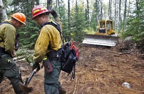
ELY, MINN. - And on the 32nd day, it rained. For the first time in more than a month, weather became a significant ally in the fight against the Pagami Creek fire in the Boundary Waters Canoe Area Wilderness on Sunday. The misty drizzle that began falling, as promised, early in the day helped firefighters extend the containment line to 19 percent by late Sunday. "You've heard, 'Make hay while the sun shines,'" said Doug Anderson, public information officer for the National Forest Service. "Well, we make fire line when it rains." Though the rain is too light to soak the tinder-dry forest, it prevents the light-fuel-like grass and leaves from igniting. Even more rain is expected later next week. "That's a big positive," Anderson said. The weather has been getting increasingly cool and damp throughout the week as the number of people brought in to control the fire has grown. That number is expected to reach about 600 by early this week."
Photo credit above: Forest Service firefighters Ryan Pederson, left, and Kory Borgman directed a bulldozer through the woods south of Isabella Lake. The BWCA Pagami Creek fire was slowed by rainfall, giving firefighters a chance to build fire breaks and shore up other defenses. (photo: Marlin Levison).
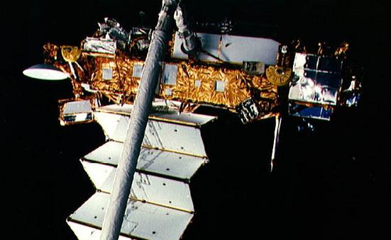
Feeling Lucky? According to
space.com and NASA a huge, defunct satellite is forecast to plunge to the Earth later this week, probably Friday. More details: "
A dead climate satellite that has been circling Earth for 20 years will make a fiery death plunge this week, with some pieces of the 6 1/2 ton spacecraft expected to reach the surface of the planet, NASA officials say. The bus-size Upper Atmosphere Research Satellite, or UARS, will likely plummet down to Earth sometime around Friday (Sept. 23), according to NASA's latest projections. There is a 1-in-3,200 chance that UARS debris could hit a person, though NASA considers that scenario extremely remote. "Re-entry is expected Sept. 23, plus or minus a day," NASA officials wrote in an update posted Sunday (Sept. 18). That means that by Saturday (Sept. 24), the UARS satellite should slam into Earth's atmosphere and break apart."
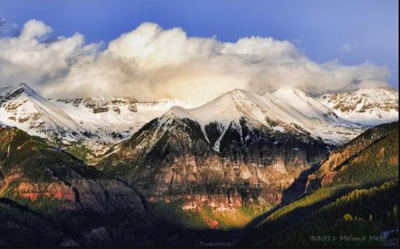
Photo Of The Day: Winter Premonition. Thanks to Melanie Metz for sending in this terrific photo taken near Telluride, Colorado. Plenty of snow above 8,000 feet!
Sunday Severe Storm Reports:
Large Hail:
- 2.00″ (hen egg/lime) hail near Garland, TX
- 1.75″ (golf ball) hail near Gainesville, TX
- 1.75″ (golf ball) hail near Nashville, AR
- 1.75″ (golf ball) hail near Broken Bow, OK
- 1.75″ (golf ball) hail near Garland, TX
- 1.50″ (walnut/ping pong ball) hail in Horatio, AR
- 1.25″ (half dollar) hail in McKinney, TX
- 1.25″ (half dollar) hail near Garland, TX
Wind Gusts:
- 70 mph in Seagoville, TX
- 60 mph in Emblem, TX
- 60 mph in Dallas, TX
- 60 mph in Waxahachie, TX
Giant Hailstones Better Recorded in Social Media.
Kansas.com has a story about how social media (Facebook, Twitter, etc) are helping with the accurate collection of severe storm reports around the nation: "
The radar map looked like a textbook setup for a stormy day in May, but this was mid-September. Supercell thunderstorms fired up west of Wichita, then slid southeast. The storms produced a couple of short-lived tornadoes and huge hailstones. So large, in fact, that a record for the largest hailstone in state history was set: a stone that fell in southwest Wichita had a diameter of 7.75 inches, shattering the existing record by more than 2 inches. But Scott Blair, a meteorologist with the Topeka branch of the National Weather Service, came across something startling as he researched the Sept. 15, 2010, storm. Checking local media websites, he found photos of one massive hailstone after another."
NOAA Targets Hurricanes With Computer Power. NHC tradionally does a good job predicting hurricane track, but predicting hurricane intensity is far more perilous and problematic - something that may improve with faster supercomputers.
Datacenterknowledge.com has the story: "
A new supercomputing facility in West Virginia could help improve weather forecasters’ ability to predict the power of huge hurricanes, which could eventually help public officials make better decisions about when to call for the kind of mass evacuations seen during Hurricane Irene. Next month The National Oceanographic and Atmospheric Administration (NOAA) will bring a new data center online. The facility in Fairmont, West Virginia will support a 383-teraflop supercomputer designed to develop more powerful tools for analyzing the behavior of hurricanes. NOAA staffers discussed the project in a presentation last week at the AFCOM Data Center World fall conference in Orlando......The damage caused by the hurricane has almost everything to do with intensity,” said NOAA’s Darren Smith, who said predicting the intensity requires granular data.”The physics of a hurricane occur at a 1 kilometer resolution.” The new supercomputer in West Virginia will bring more horsepower to test new models designed to better measure intensity. But it will also require about five years of development before the new model is ready for use in NOAA forecasts."
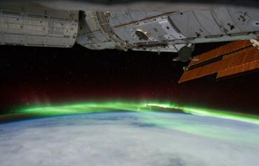
Astronauts Capture Aurora Australis South of Australia. Here's an amazing clip from
NASA, video rolling as the ISS, the International Space Station, passes OVER the region impacted by a stunning aurora: "
This video of the Aurora Australis was created from a sequence of still shots taken by astronauts on board the International Space Station. The images were acquired on September 11, 2011 as the ISS orbit pass descended over eastern Australia, reached the "bottom" of the orbit, then changed direction to an ascending pass just east of New Zealand during the night hours -- in essence describing a wide "U" over the region. Dense cloud cover obscures the land and sea surface during much of the video. The aurora displays a sinuous green ribbon shape -- with occasional hints of red near the upper extent -- throughout the video. The unique viewing perspective from the ISS cupola allows for a sense of the 3-dimensional nature of the phenomena as it varies in apparent length, width, and thickness as the ISS orbits above it."
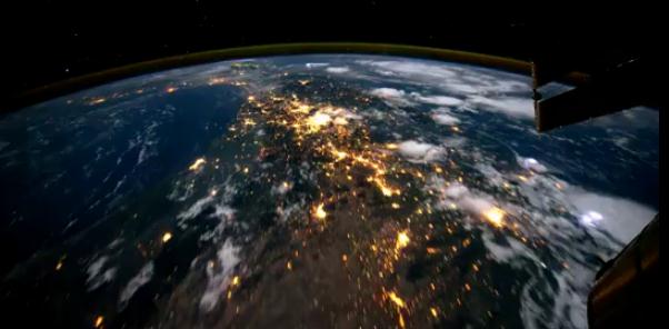
What Does It Feel Like To Fly Over Planet Earth? Here's an amazing YouTube video clip, courtesy of
NASA: "
A time-lapse taken from the front of the International Space Station as it orbits our planet at night. This movie begins over the Pacific Ocean and continues over North and South America before entering daylight near Antarctica. Visible cities, countries and landmarks include (in order) Vancouver Island, Victoria, Vancouver, Seattle, Portland, San Fransisco, Los Angeles. Phoenix. Multiple cities in Texas, New Mexico and Mexico. Mexico City, the Gulf of Mexico, the Yucatan Peninsula, Lightning in the Pacific Ocean, Guatemala, Panama, Columbia, Ecuador, Peru, Chile, and the Amazon. Also visible is the earths ionosphere (thin yellow line) and the stars of our galaxy. Raw data was downloaded from; The Gateway To Astronaut Photography of Earth "http://eol.jsc.nasa.gov/sseop/mrf.htm "
Four Seasons In A Single Picture. O.K. This is pretty cool. Thanks to
funcram.com for sharing these pics. Call me crazy, but I think these were Photoshopped....
Farmers Warn Of Post-Irene Pumpkin Shortage. Oh no, not the pumpkins! The
Bangor Daily News has more (unfortunate) details: "
NEW YORK — Northeastern states are facing a jack-o’-lantern shortage this Halloween after Hurricane Irene destroyed hundreds of pumpkin patches across the region, farmers say. Wholesale prices have doubled as farmers nurse their surviving pumpkin plants toward a late harvest. Some farmers are trying to buy pumpkins from other regions to cover orders. “I think there’s going to be an extreme shortage of pumpkins this year,” said Darcy Pray, owner of Darcy’s Family Farms in Keeseville, in upstate New York “I’ve tried buying from people down in the Pennsylvania area, I’ve tried locally here and I’ve tried reaching across the border to some farmers over in the Quebec area. There’s just none around.” Hurricane Irene raked the Northeast in late August, bringing torrents of rain that overflowed rivers and flooded fields along the East Coast and into southern Canada. Pray saw his entire crop, about 15,000 to 20,000 pumpkins, washed into Lake Champlain."
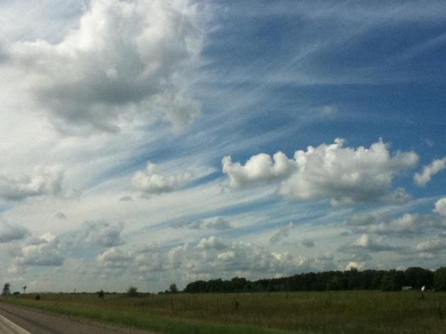
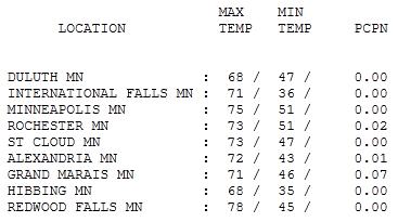
A Fine Monday. After a gray, foggy start the sun broke through, enough blue sky for highs in the upper 60s to mid 70s. Highs ranged from 68 at Hibbing and Duluth to 73 at St. Cloud, 75 in the Twin Cities and 78 at Redwood Falls.
Paul's Conservation Minnesota Outlook for the Twin Cities and all of Minnesota:
TODAY: Mostly cloudy and windy, few passing showers. Winds: SW 15-25 High: near 70
TUESDAY NIGHT: Windy and unsettled with a few more showers and sprinkles. Low: 50
WEDNESDAY: Cloudy, gusty and cool with sprinkles. High: 57
THURSDAY: Bright sun, winds ease. Low: 44. High: 62
FRIDAY: Blue sky, milder. Low: 46. High: near 70
SATURDAY: Sunny and spectacular! Low: 55. High: 74
SUNDAY: Sunny. Shorts and T-shirts? Low: 58. High: near 80
MONDAY: Indian Summer lingers. No worries. Low: 59. High: 77
Wind Advisory Today
"Fear less, hope more; eat less, chew more; whine less, breathe more; talk less, say more; hate less, love more; and all good things are yours" goes my favorite Swedish proverb. September is a time for reflection, looking back on a summer that FLEW by, anticipating football season and the holidays to come, plotting a winter-survival-strategy.
I just hired a TV meteorologist from Alabama who is scared to death of our winters. I told David the truth: a warm coat, a few extra layers, and a couple of well-timed southern getaways will suffice. Sometimes the THOUGHT of a vacation can be almost as good as the trip itself.
A clipper-like system arrives with showers today; Wednesday will feel like October with windblown sprinkles - light jacket weather. Skies clear Thursday, and a massive ridge of high pressure building over the Plains will treat us to 70s by the weekend; 80 not out of the question by Sunday. The last week of September will restore your faith in a Minnesota autumn, a winning streak of 70s.
Even though the immediate MSP metro didn't see a frost, much of Minnesota did endure freezing temperatures last week. So it's perfectly appropriate to call this weekend's surge of 70s and low 80s "Indian Summer". The only fly in the ointment? A "cut-off low" forecast to stall near Chicago over the weekend. Right now it appears clouds/showers will stay south/east of MN, but it may be a close call.
Bring it!
Seeking Better Answers To Climate Change, Extreme Weather Questions. Andrew Freedman from the Washington Post's prolific and insightful
Capital Weather Gang has a thoughtful story about establishing a scientific link between a warming atmosphere and a subsequent increase in extreme weather, worldwide: "
The United States has suffered from a record number of billion dollar natural disasters this year, from the Mississippi and Missouri River flooding to Hurricane Irene and the Texas drought. With each of these events, many have wondered - did climate change have anything to do with this? Reporters and members of the public wanted to know: has climate change vaulted us into a new normal, as some climate scientists have warned for years, in which these kinds of devastating events will occur more frequently, and be more severe? Or is this just one awful and anomalous year? Depending on the extreme event, climate science has provided some answers, but they have contained significant caveats, largely because the links between climate change and specific extreme weather events are tenuous, and only now being investigated using methods that are showing greater promise."
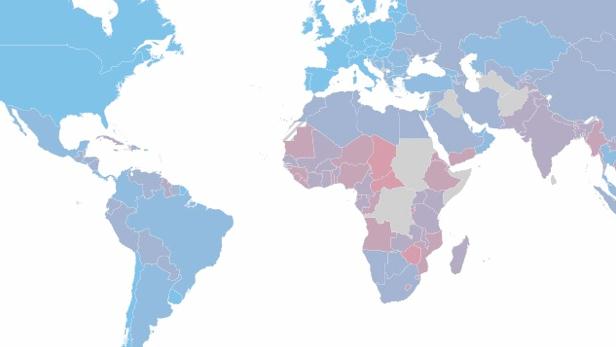
Is Your Country Prepared For Climate Change? The story from
Fast Company: "
Using different factors to assess how well a country can respond to changes in food and water availability (as well as rising seas), the Global Adaptation Index shows which countries have the most work to do to prepare. Climate change is here, and as it worsens, it will affect the entire planet. But it's the hard truth that it won't happen equally: Some areas will be affected more than others. Those areas, one would hope, would be spending the most time and energy preparing for the eventualities of drought, food shortages, and rising sea levels. But this is largely not the case. The most ill-prepared countries are the ones that will be hit the hardest. That's just one of the major conclusions of the Global Adaptation Index (GAIN), which provides scores for every country based on their vulnerability to climate change and their readiness to deal with those issues. Denmark is ranked the highest (it isn't very vulnerable to begin with, and has done a lot to get ready), while Ethiopia, which is doing very little while being very threatened, is the lowest. On the map above, the more red a country is, the worse their score."


No comments:
Post a Comment