51 F. high in the Twin Cities Wednesday.
.86" rain predicted between November 6-8 (GFS model).
Trace of snow: one year ago today in the Twin Cities, October 27, 2010. First snow of the winter season at MSP last year.
October 16: average date of the first flurries in the Twin Cities.
Snowfall so far this month:
0. No flurries at MSP....yet.
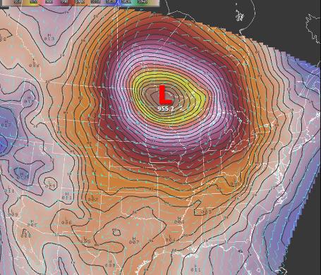
28.21" mercury: lowest pressure ever observed in Minnesota at Bigfork, Minnesota on October 26, 2010.
28.60" pressure reported in the Twin Cities on October 26, 2010 - second lowest on record.
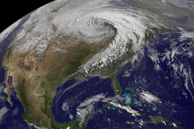
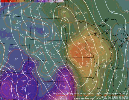
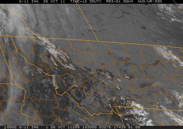
"Landicane". Here is a visible image taken October 26, 2010, showing the cyclonic swirl of clouds associated with an unusually powerful area of low pressure, whipping up 60-70 mph winds and record low barometric pressure readings.
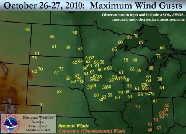
60-62 mph: peak wind gusts in the Twin Cities metro during the October 26, 2010 super-storm.
"
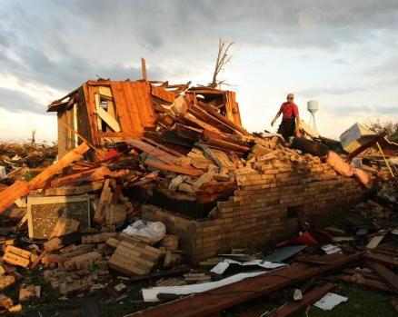
This spring's tornado season has cost insurers nearly $15 billion so far, just behind the $23.1 billion World Trade Center attack in 2001, this year's $35 billion Japan quake and the $72.3 billion Hurricane Katrina disaster in 2005, according to an analysis by insurers." - story on tornado clean-up at timesfreepress.com.
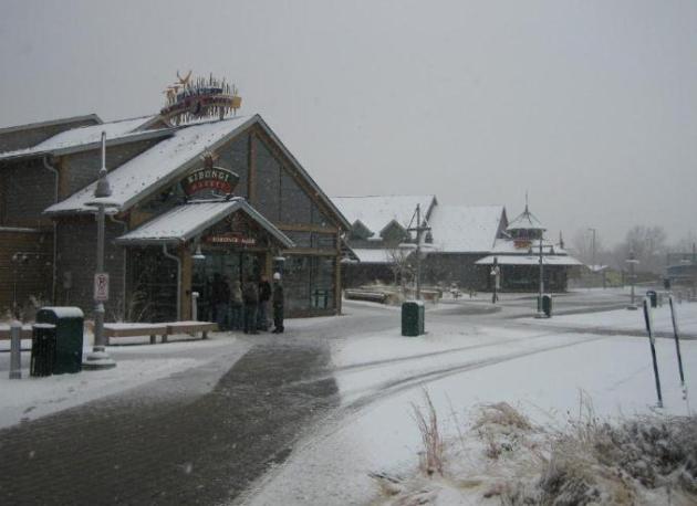
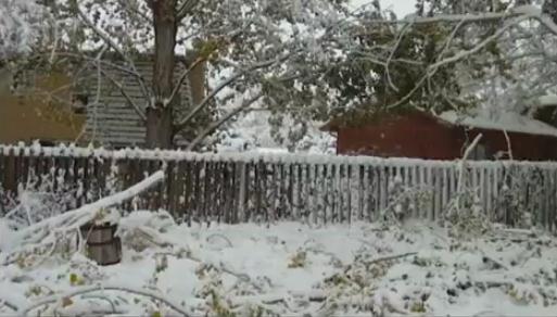
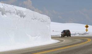
Denver Snow Blitz. Here is a frame-grab from the
Denver Zoo, taken Wednesday at 9:30 am (when 4" of slushy snow had already accumulated). Hard to believe it was 80 Monday afternoon in the Mile High City.
18.2" snow at Jamestown, Colorado.
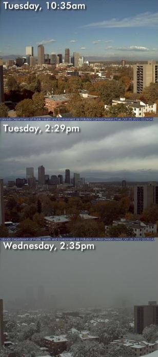 What A Difference A Day Makes!
 Denver's snowy makeover took less than 18 hours to accomplish - time lapse photo series courtesy of the Denver Examiner.
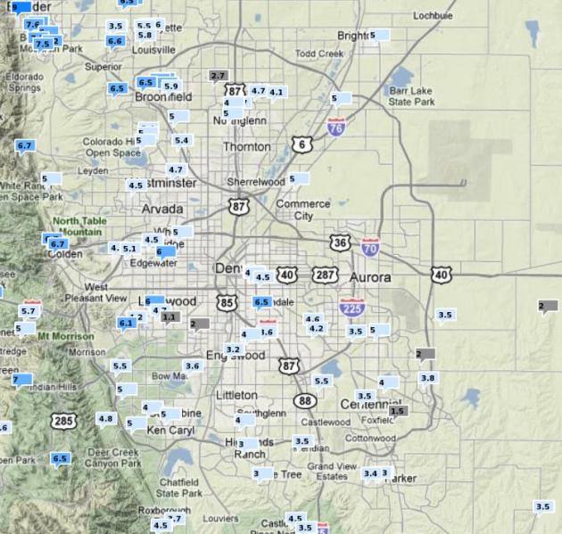
Interactive Denver Snowfall Tool. The Denver NWS has done a good job collecting and visualizing snowfall and rainfall amounts - click
here to see the latest snow totals.
Snowy Before And After. Here is a
YouTube clip from Ft. Collins, Colorado, showing the (rapid) transition from autumn to winter, complete with fallen tree limbs, the result of 8-10" of heavy wet snow: "
Had a big winter storm hit Colorado last night. I took some footage yesterday ahead of the storm, and more this morning, showing all the snow and broken tree branches!"
One Year Ago: Record Low Pressure For Minnesota. What a difference a year makes. Here's a
special statement that went out from the Twin Cities NWS on October 26, 2010. "
A new low pressure record was set for the state of Minnesota. At 5:13 pm on October 26th, a pressure of 955.2 mb* (28.21 inches of mercury) was observed at Big Fork, Minnesota, located in the north central part of the state. The previous record was 962.7 millibars (28.43"), set on November 10, 1998 at both Albert Lea, MN and Austin, MN."
"One of the deepest extratropical low pressure systems on record for the lower 48 states evolved from Iowa into Minnesota on October 26th and slowly moved northeast on the 27th. Such a low developed in response to powerful 175 kt jet stream winds from the west and a major contrast in temperatures, with warm and moist air to the south and colder air building to the north. A low pressure area in advance of this system had already tightened the temperature gradient, or as meteorologists say, increased the baroclinicity. This set the stage for even lower pressures as the strong jet stream moved atop the area." (source: Twin Cities NWS).
Peak Winds. Last year's record low pressure created a partial vacuum as it drifted across Minnesota, air accelerating into this atmospheric "bomb" accelerated close to hurricane force, numerous wind gusts of 60-70 mph across the Upper Midwest. Map courtesy of the National Weather Service.
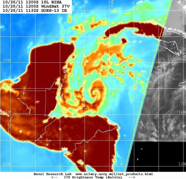
Rina "Unwinding". The combination of wind shear and very air in the Gulf of Mexico getting tangled up in the storm's circulation should imply further weakening in the coming days - the odds of a major hurricane striking Florida dropping off with each passing hour. Enhanced satellite image courtesy of the Naval Research Lab.
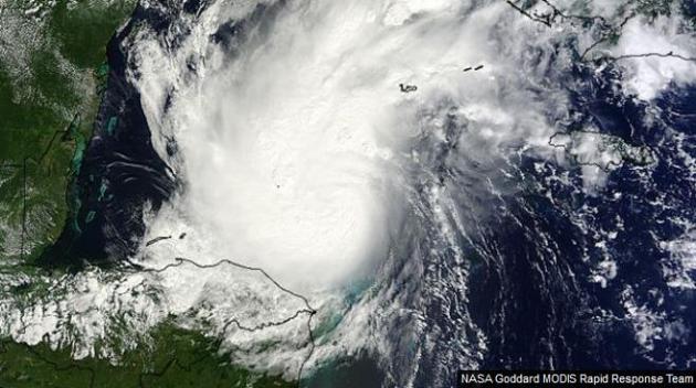
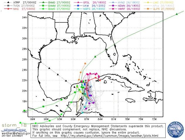 Rina: Forecast To Fizzle
. Only 1 computer solution brings the soggy remains of Rina into Florida (near Tampa). Odds favor rapid weakening between Cancun and Havana as dry air wraps into the storm center and wind shear shreds the circulation.
Hurricane Rina Rages In Space Station Astronaut Video. Details from
foxnews.com:
"From high above Earth, the astronauts on the International Space Station have a unique view of the menacing Hurricane Rina raging below, and by the looks of a video recorded today (Oct. 25), the view from space reveals quite a storm. "We have a view of Hurricane Rina in the video camera here," space station commander Mike Fossum of NASA radioed to Mission Control in Houston. It's a biggun." From Fossum's perspective, the cloudy white mass of the hurricane can clearly be seen beneath the space station as it passes overhead. The video of Hurricane Rina from space compiles multiple camera angles from the orbiting lab. The footage was captured at 2:39 p.m. EDT (1830 GMT) today as the space station flew 248 miles (399 kilometers) over the Caribbean Sea, east of Belize."
Most Likely Scenario: Rina Weakens, Soaks Cuba, Possibly South Florida. The more Rina weakens, the result of wind shear and dry air entraining into the system, the lesser the odds it will impact Florida. The storm is weakening, and it may still brush the Florida Keys with heavy rain, but a series of cooler fronts will steer Rina away from the Gulf coast.
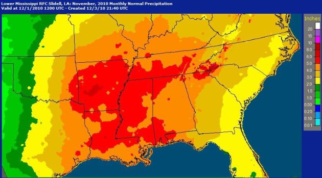
Normal November Rainfall For Lower Mississippi River Valley. Here's a look at how much rain should fall during the month of November, courtesy of the National Weather Service: “
Compared to October, average rainfall in November increases slightly over the lower Mississippi basin. This corresponds to fronts that begin to make it further south toward the Gulf of Mexico. The first few fronts tend to be dry because the jet stream is still to the north, but moving into November the jet stream gets closer to the Gulf, helping create low pressure systems in our area.”
Big Sky Country. Here's a good summary of Montana weather from the NWS: “
Satellite imagery can tell us about more than just cloud-cover. Clear skies this afternoon and visible satellite imagery allows us to see surface features, including mountain ranges, lakes and some of the newly snowcapped peaks and ridges across western and central Montana.”
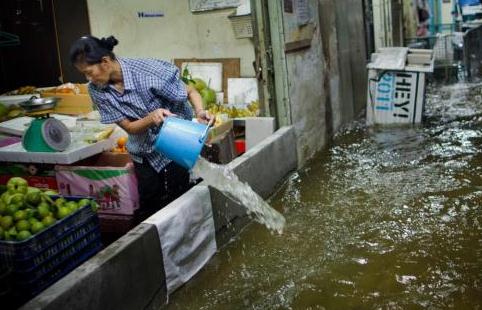
Thousands Leave Flood-Surrounded Thai Capital.
USA Today has an update on the worst flooding since 1942: "
BANGKOK (AP) – Bangkok residents jammed bus stations and highways on Wednesday to flee the flood-threatened Thai capital, while others built cement walls to protect their shops or homes from advancing waters surging from the country's flooded north. "The amount of water is gigantic," Prime Minister Yingluck Shinawatra said. "Some water must spread into Bangkok areas but we will try to make it pass through as quickly as possible." Some neighborhoods on the city's fringes were already experiencing waist-high flooding, but central areas remained dry. Everywhere, people were preparing for flooding that seemed all but inevitable. Websites posted instructions on the proper way to stack sandbags. Many residents fortified vulnerable areas of their houses with bricks, gypsum board and plastic sheets. Walls of sandbags or cinderblocks covered the entrances of many buildings."
Insurance Disputes Stall Post-Tornado rebuilding Efforts. Insurance companies dragging their feet? Hard to imagine, huh?
Timesfreepress.com has the details: "
The shaky cell phone videos of the swirling black masses that devastated Ringgold, Ga., and parts of Apison on April 27 tell only part of the story. Though less tragic than the vivid destruction and altered lives, every piece of tornado debris carried a dollar value. In fact, when taken as a single event, the spring 2011 tornadoes rank as the ninth costliest incident in global insurance history, according to the Insurance Information Institute. This spring's tornado season has cost insurers nearly $15 billion so far, just behind the $23.1 billion World Trade Center attack in 2001, this year's $35 billion Japan quake and the $72.3 billion Hurricane Katrina disaster in 2005, according to an analysis by insurers. And it's not over yet. Six months after tornadoes struck the Southeast, untold numbers of homes have been bulldozed, with only a patch of mud or a weathered driveway marking their absence. Many more are in various stages of repair, while others remain shattered and empty."
Custom Calendars. If anyone asks (doubtful) today will bring 10 hours and 27 minutes of daylight to the Twin Cities. We've lost about 5 hours of daylight since June 21. Interested in sunrise/sunset, or even moonrise and moonset, and the total quantity of daylight (for any city?) Click
sunrisesunset.com for a calendar, on-demand.
Facebook Is Serious TV Rival. The story from Media Daily News at
mediapost.com: "
Daytime is Facebook time, not TV time, for most media consumers. Facebook is closing in on being a mass medium -- just like TV, according to a study by Frank N. Magid Associates Generational Strategies. More consumers use Facebook during workday hours -- 9 p.m. to 5 p.m. --than watch TV. The survey says only baby boomers are the exception -- 35% report they are watching TV, versus 26% who say they are using Facebook. Thirty-two percent of Gen Xers -- those 35-46 -- use Facebook during daytime. compared to 28% who watch television. Those 18-34 are using Facebook 44% compared to 32% for television. Teen millennials use Facebook 30% versus 24% for TV. Younger groups 8-14, which the study calls "iGens," are the only younger viewers to give TV parity compared to Facebook -- at 16% each."
 The Dark Season
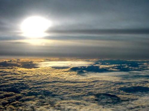
. November is the cloudiest month of the year, on average, and Wednesday was a preview of coming attractions. At least the sun came out later in the afternoon, enough brightening for a high of 50 at St. Cloud and 51 in the Twin Cities. A trace of rain fell in the metro area, with .03" at Alexandria.
File Photo. Nothing to worry about......yet.
Paul's Conservation Minnesota Outlook for the Twin Cities and all of Minnesota:
TODAY: More clouds than sun. Brisk. Winds: NW 10. High: 49
THURSDAY NIGHT: Partly to mostly cloudy - chilly. Low: 34
FRIDAY: Mix of clouds and sun, cool and dry. Showers over the MN Arrowhead. High: 49
SATURDAY: Frosty start, fading sun as PM clouds increase. Nicer day of the weekend. Winds: S 10. Low: 32. High: 51
SUNDAY: Unsettled, slight chance of a passing shower or two. Low: 37. High: 49
MONDAY: Sunnier, milder Halloween. Dry for Trick or Treating. Low; 36. High: 54
TUESDAY: Intervals of sun, hello November! Low: 42. High: 56
WEDNESDAY: Mostly cloudy, turning cooler. Low: 41. High: 51
Little To Gripe About
"Paul, I'm a good Minnesotan. I love all 4 seasons. But getting up in the dark and driving home in the dark is wearing on me." Try "full spectrum" lights. Pick up bulbs at Fleet Farm or Menards; they can help your state of mind.
And what a difference a year makes. A year ago today we were cleaning up fallen tree limbs, the result of 60 mph gusts in the Twin Cities. A powerful storm sparked the second lowest pressure on record for MSP (28.6"). Bigfork, Minnesota saw a barometric pressure of 28.21", setting a new state record. We went on to have a wild winter: 86", 4th snowiest on record.
Meteorologists look for "high-amplitude" patterns, big dips and bulges in the steering winds, capable of yanking arctic air south, or pushing moist air north from the Gulf of Mexico. That's when the BIG storms (and bitter fronts) materialize.
I'm seeing a predominately zonal, west-to-east wind flow into the first week of November, a pattern that favors fewer big storms, temperatures near or above average. Highs approach 50 through Halloween, nothing too scary on the maps. Models hint at significant rain the first weekend of November.
Rina may weaken and even fizzle before having a chance to impact Florida. The odds of a significant hurricane strike have diminished considerably.
Climate Change Skeptic Turns Skeptical About The Skeptics. Got it? The story from
zdnet.com: “
Global warming is real,” Muller wrote in his column for the WSJ discussing his findings. “Perhaps our results will help cool this portion of the climate debate. How much of the warming is due to humans and what will be the likely effects? We made no independent assessment of that.” Muller’s article discusses in fine detail all the reasons why both scientists and the general public have a right to be skeptical, including what he describes as the “largely awful” data quality that is collected by the temperature stations around the United States. The margin of error at 70 percent of those stations, Muller figured, is between 2 degrees and 5 degrees Celsius. What’s more, instruments have changed over time and the local environments have changed. All that makes the data questionable, Muller admitted in his WSJ column. That’s why Muller and his team took a different approach, collecting more than 1.6 billion measurements from 39,000 stations around the world. That approach revealed the following: one-third of the world’s temperature stations have recorded cooling temperatures, while two-thirds have recorded warming ones. This ratio reflects global warming, Muller wrote: “The changes at the locations that showed warming were typically between 1 degree to 2 degrees Celsius, much greater than the [Intergovernmental Panel on Climate Change]’s average of 0.64 degrees Celius.”
* Dr. Muller's explanation of his research and findings was published in the
Wall Street Journal.
 Climate Control
. As their ranks diminish, global warming skeptics target scientists, as reported by
The American Prospect: "
Last week Richard Muller and his team released the findings of their exhaustive study on global warming with definitive simplicity, saying flatly “global warming is real.” The statement is an especially damning one to climate change deniers, as Muller, himself once a global warming skeptic, conducted the study partly with funds from the Koch brothers. As even skeptics like Muller begin to accept the overwhelming science behind global warming, opponents are taking up a new tactic that goes after the scientists themselves. One of these scientists is Michael Mann, a climatologist who, since January, has been targeted by climate-deniers. Following the example of the tobacco and pharmaceutical industries, which have a tradition of attacking the credibility of scientists who oppose their products, skeptics are beginning question the credentials and research of individual scientists. Since 2007, when a Supreme Court ruling found that, under the Clean Air Act, the EPA has the right to regulate greenhouse gas emissions based on the threat to human health, global warming skeptics have been left to assert their views in the court of public opinion. The lesson they learned was, if you can’t attack the science, attack the scientist."
The Long Hot Summer And Code Red Days. An article at
Huffington Post: "
The once-dreaded idiomatic expression "the long, hot summer" regained a literal patina or shade of meaning during the summer months of 2011. Cities are no longer "aflame in the summer time," and even the venerable Farmers' Almanac predicted it would be a white-hot summer. Across these United States, it was the hottest summer in 75 years, and the second-warmest summer on record, the National Climatic Data Center has confirmed. It was also the fifth-hottest summer in the Northern Hemisphere since scientists began compiling such climatological records 132 years ago. Well, you don't have to "know much about a science book," or global climate change, to realize our summers are hotter than ever before. Yet, there has been a significant reduction in the amount of pollution caused by automobiles in the Washington metro region. That's a major milestone, since the smog standards are now more stringent than ever before for the average concentrations of ozone at ground level over an eight-hour period. This is vital and paramount because 1.5 million people who live and move and have their being in the Washington-Baltimore region fall within the sensitive groups impacted by unhealthy air quality."
Commentary: Climate Change Deniers May Be Washed Away By Rising Seas. Here's an Op-Ed in the Miami Herald, reprinted by the
Kansas City Star: "
The rising sea will wash across great swaths of South Florida. Salt water will contaminate the well fields. Roads and farmland and low-lying neighborhoods will be inundated. The soil will no longer absorb the kind of heavy rainfalls that drenched South Florida last weekend. Septic tanks will fail. Drainage canals won’t drain. Sewers will back up. Intense storms will pummel the beachfront. Mighty rainfalls, in between droughts, will bring more floods. The economic losses and the mitigation costs associated with the effects of global warming over the next few decades will be overwhelming. It will cost a medium-sized town like Pompano Beach hundreds of millions just to salvage its water and sewage systems. A sobering study released by Florida Atlantic University contemplated the effects of global warming in specific terms, particularly for South Florida, considered one of the more vulnerable metropolitan areas in the world, with six million residents clustered by the ocean, living barely above sea level.


No comments:
Post a Comment