October 17, 2004: "trace" of flurries in the Twin Cities with a high of 39 F.
Paul's Conservation Minnesota Outlook for the Twin Cities and all of Minnesota:
TODAY: More clouds than sun. Gusty. Winds: NW 15-25. High: 48 (wind will make it feel like low to mid 30s)
TUESDAY NIGHT: Patchy clouds, feels more like early November out there. Low: 34
WEDNESDAY: Mostly cloudy and raw. Passing sprinkles (few flurries can't be ruled out.) High: 47
THURSDAY: First widespread metro frost of the season possible. Bright sun, less wind. Low: 32. High: near 50
FRIDAY: Plenty of sun, milder. Low: 34. High: 56
SATURDAY: Mix of clouds and sun. Quiet. Low: 42. High: 55
SUNDAY: Intervals of sun. Touch of Indian Summer? Low: 45. High: 57
MONDAY: Some sun, turning milder. Low: 47. High: 62

First 32 F. at MSP: October 7.
First Flurries: October 16.
First coating (1/10th of an inch): November 6.
First 1" snowfall: November 18.
First "plowable" 4"+ snowfall: December 20.

2010: October 27
2009: October 10
2008: October 26
2007: November 5 (latest)
2006: October 11
2005: October 6 (earliest)
2004: October 17
61.3" rain at Williamsport, PA - wettest year on record (weather records date back to 1895).
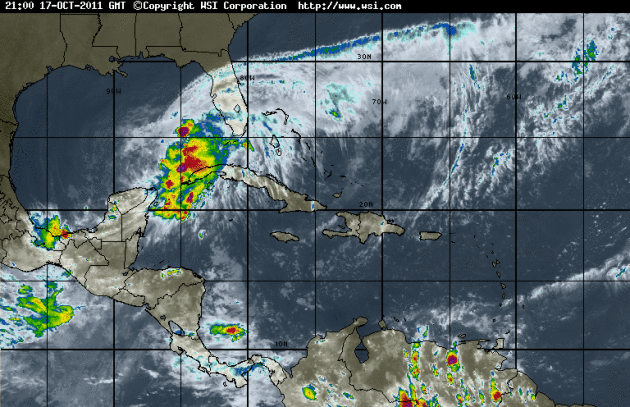
Gulf of Mexico Soaker. A tropical wave in the Gulf of Mexico has already spawned 30-40 mph winds and 10 foot seas in the central Gulf, more than 10" of rain reported over the Florida Keys. NHC says there's only a 30% probability this area of disturbed weather will strengthen into Tropical Storm Rina in the next 48 hours (too much dry air and wind shear aloft). Some of this moisture will spike the storm forecast to track up the east coast by Wednesday, resulting in some very impressive rainfall amounts.
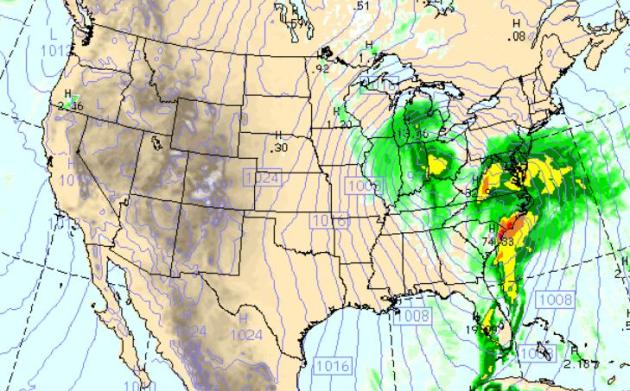
Wednesday: Major East Coast Storm. The WRF model spins up an impressive coastal storm over the Carolinas, a classic nor'easter, with a second area of low pressure hanging back over Ohio - impacting wind circulations over the eastern HALF of the USA. Models print out a little light precipitation over the Twin Cities metro Wednesday morning - by that time the atmosphere may be cold enough for sprinkles and flurries.
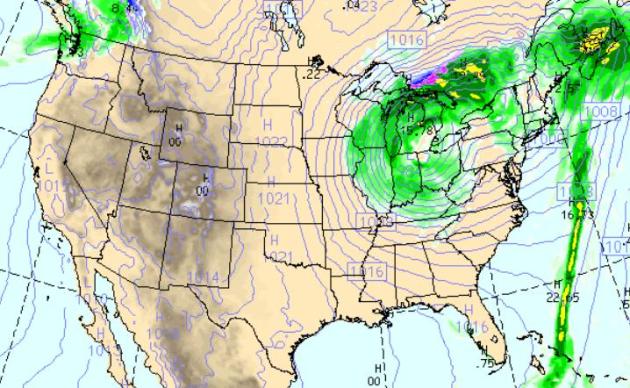
Thursday: Gales Of November Come Early. By Thursday morning models print out an extremely intense storm near Detroit, a tight pressure gradient (contrast in atmospheric pressure) whipping up 30-45 mph winds over the Great Lakes and the Upper Midwest as a cold rain mixes with wet snow over the U.P. of Michigan.
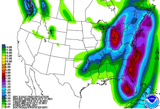
Major Rain-Maker. NOAA's 5-Day QPF (quantitative precipitation analysis) prints out some 4" rainfall amounts for Cleveland, Toledo and Detroit, 3" or more from Florida into the Carolinas, some 1-2" amoutns for New York, Providence and Boston.


Bangkok's Governor Calls For Sandbags As Floods Besiege Thailand's Capital. It seems that Bangkok isn't quite out of the woods just yet, as reported by Bloomberg: "Bangkok Governor Sukhumbhand Paribatra appealed for more than a million sandbags to prevent flooding in the Thai capital as a “huge amount” of water from northern dams threatens to deluge inner parts of the city. “Every minute is critical from now on,” he told a televised press briefing late yesterday in which he asked for 1.2 million sandbags. “We urge the government to give those bags now. Otherwise, it will be too late.” Water broke into Navanakorn Pcl’s industrial zone in Pathum Thani on Bangkok’s outskirts, inundating 10 more factories, according to Wim Roongwatanachinda, a spokesman for the Flood Relief Operation Command. The disaster has killed more than 300 people and swamped at least 930 plants employing more than 300,000 workers, according to government data. Prime Minister Yingluck Shinawatra is seeking to spare Bangkok from the country’s worst flooding in 50 years after heavy monsoon rains forced officials to release large amounts of water from northern dams."

- Polar-orbiting weather satellites provide 93 percent of the data used in National Weather Service forecast models?
- Nearly 90 percent of all Presidentially-declared disasters are weather and water-related?
- Polar-orbiting satellites provide critical data for 2-10 day long-term forecasts, which are imperative for troop deployments and planning operations?
- Without data from polar-orbiting satellites, 2-5 day advance warnings of extreme events as well as everyday forecasts for highs, lows, precipitation, etc., would be significantly diminished?
- Without data from NOAA’s polar afternoon orbit, the “snowmageddon” event in Feb. 2010 would have been under-forecast by at least 10 inches?
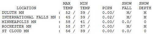

Brisk Blue Sky. The sun was out over central Minnesota, including the Twin Cities, enough blue sky for a high of 56 at St. Cloud and 58 in the Twin Cities, which is average for October 17. "Backlash" clouds rotating in from Ontario leaded .02" rain on International Falls, reports of a light rain/snow mix just north of the Minnesota border.

In Search of "Average"
You can prove anything with statistics. On paper a Minnesota winter appears harsh, cruel - borderline barbaric. But with the right clothing, a few good space heaters, and the right frame of mind you can not only survive, but thrive.
On average our first flurries arrive October 16, the first coating capable of icing up your morning commute: November 6. The first 1" snowfall usually comes on November 18, and the first "plowable" (4"+) snow doesn't come until December 20. The obligatory Christmas snow. A holiday "high" spills over into January. True, February can be a long, dark month, but a full-spectrum light (that mimics the sun) and a couple of well-time southern getaways can keep you from slipping into a slushy funk. The very best antidote? Get out and PLAY in the snow! Skiing, ice fishing; there is nothing as exhilarating as zooming down a freshly groomed trail on a snowmobile.
A sprawling storm over Ontario may push a few windblown sprinkles and flurries into town Wednesday; no snow will actually stick on the ground close to home. The first 32 F. is possible Thursday, coming about 2 weeks later than average. Indian Summer returns this weekend - another shot at 60 degrees!
* photo above courtesy of Mary Decker.
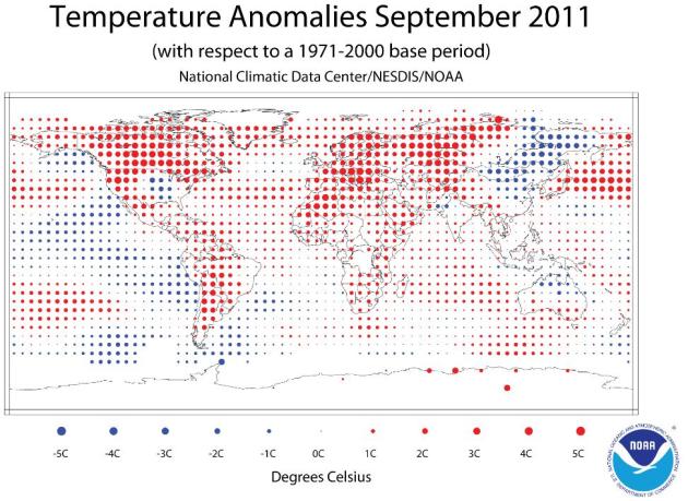
- The combined global land and ocean average surface temperature for September was the eighth warmest on record at 59.95˚F (15.53˚C), which is 0.95˚F (0.53˚C) above the 20th century average of 59.0˚F (15.0˚C). The margin of error associated with this temperature is +/- 0.20˚F (0.11˚C).
- Separately, the global land surface temperature was 1.57˚F (0.87˚C) above the 20th century average of 53.6˚F (12.0˚C), making this the fourth warmest September on record. The margin of error is +/- 0.43˚F (0.24˚C). Warmer-than-average conditions occurred across Europe, northern and western Africa, western Russia, the western and northeastern United States, Canada, and Mexico. Cooler-than-average regions included much of eastern Asia, and part of the central United States."


No comments:
Post a Comment