85 F. high in the Twin Cities on Tuesday. Orlando, Florida also saw a high of 85 yesterday.
87 F. high predicted for today (breaking the old record of 86 set in 1912).
October 21: average date of the last 70-degree high in the Twin Cities.
October 1: average date of the last 80-degree high in the Twin Cities (Pete Boulay, MN State Climate Office).
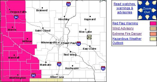 Red Flag Warning.
 The combination of bright sun, growing drought, low humidity and gusty winds are creating ripe conditions for wildfires from southwestern Minnesota into Nebraska. More from the NWS: "
Unseasonably warm temperatures, dry air, and strong southerly winds will result in dangerous fire weather conditions....use extreme caution if outdorrs and using anything or partaking in any activities that could result in a spark that could start a fire. Fires could become dangerous and fast-moving in a short period of time due to the gusty winds and low humidity."
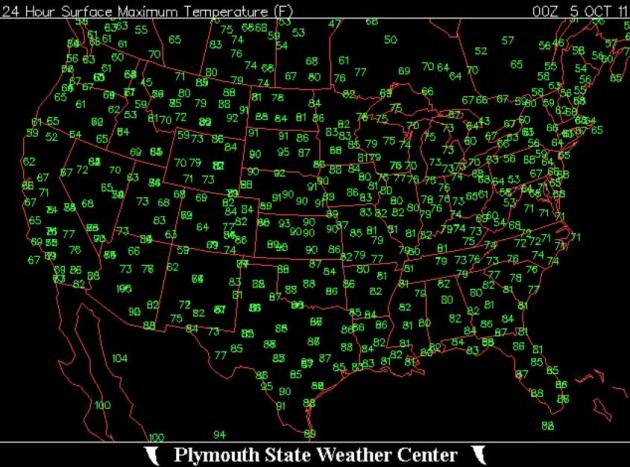 Tuesday Highs.
 Yesterday was warmer in North Dakota than Florida...or Texas. Highs held in the 50s and 60s over New England - comfortable 80s over the southeast - much cooler air pushing into the far west, setting the stage for the first significant snowfall of the season. Map courtesty of
Plymouth State Weather Center.
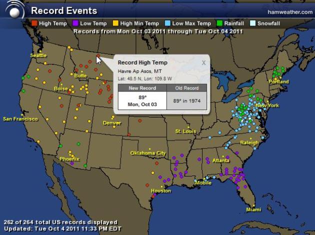 Crazy Extremes. Here
 are the records experienced Monday and Tuesday of this week - record cold, rain and snow out east, record warmth for the northern tier states and much of the west. Map courtesy of Ham Weather.
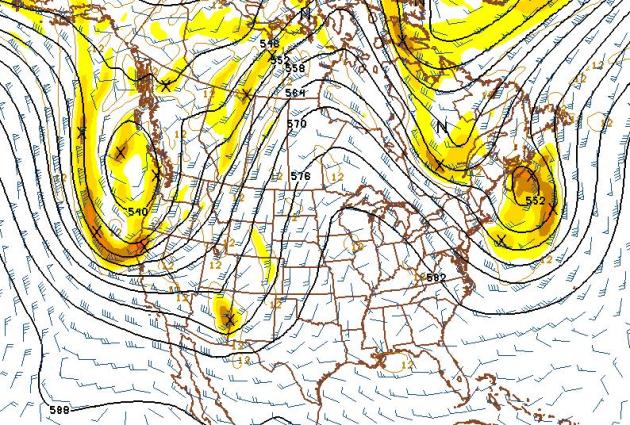 Omega Block
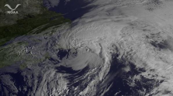
. The weather over North America has been stuck in a holding pattern - a nearly stationary storm over the east resulting in flooding rains, mountain snows and record chill - another (even stronger) storm diving into the west will dump out some 1-2 foot snowfall amounts from the Sierra Nevada range of California (above 6,000 feet) into the San Juan Mountains of Colorado. Sandwiched in-between these two powerful lows - a sprawling ridge of high pressure over the nation's midsection, responsible for record-setting 80s, even some 90s - one more taste of August!
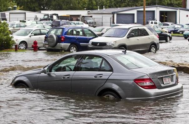
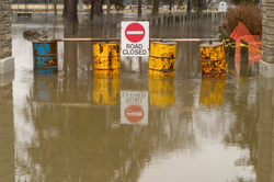
4.9" rain at Swampscott, Massachusetts yesterday. 3-5" rains Tuesday morning fell on the northeastern suburbs of
Boston, resulting in significant flash flooding. (photo courtesy of
boston.com).
The 2011 Monsoon season, defined as encompassing the period 15 June-30 September, was the hottest on record at
Phoenix. The average temperature, 95.0 F, broke the previous record of 94.5 F established in 2007. The average maximum temperature, 106.7 F, also set a new record, eclipsing the previous record of 106.4 F established in 1989, while the average minimum temperature, 83.3 F, was the second-warmest on record (83.4 F in 2007).
Massive Dust Storm: Witnesses tell KVOA-TV in
Tucson as many as 30 vehicles may be involved in the wreck near Picacho. There are reports of injuries, and several emergency crews are responding. Authorities say visibility has been reduced to zero because of intense dust blowing in the area. The
Arizona Department of Transportation reports the interstate is closed in both directions. Information courtesy of KTAR.com
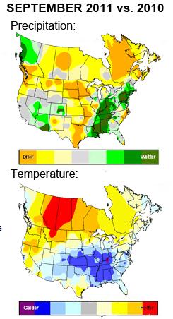
* Wettest September for
North America since 1999.
"...
The $80 billion in FEMA aid over the last decade is more than quadruple the amount doled out in the 1960s, adjusted for inflation." - from an article at philly.com below.
“...
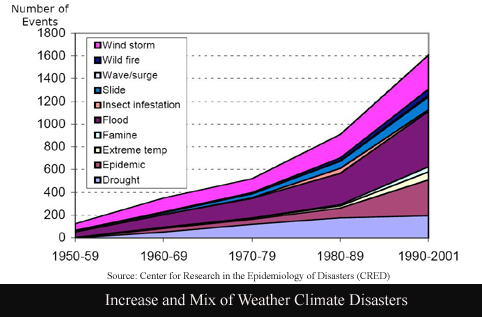
The federal government issued 86 disaster declarations as of September 30, breaking the previous annual U.S. record total of 81, which was set just last year,” said Dr. Robert Hartwig, an economist and president of the I.I.I. “The number of U.S. disaster declarations has been trending sharply upward, particularly over the past 15 years,” he said. The average number of disaster declarations between 1953 and 2010 was 34 per year." - from an article at the Insurance Journal.
"...
Looking back nearly 60 years, Texas and California have had the highest number of federal disaster declarations whereas three states are tied for having the fewest: Wyoming, Utah and Rhode Island, according to the I.I.I." - Insurance Information Institute.
"...
U.S. airlines are canceling flights at the fastest clip in a decade as storms from blizzards to hurricanes wallop the busiest hubs, and full planes are making it harder for stranded travelers to rebook trips. United Continental Holdings, Delta Air Lines and other large carriers have scrubbed almost 104,000 flights this year through Sept. 21, or 2.36 percent of the scheduled total. A full-year rate at that level would be the highest since 2001, according to the federal Bureau of Transportation Statistics." - article on bad weather impacting flight cancellations in the Post Gazette below.
"...
Whether it's planning for retirement or losing weight, we find it too easy to disregard very clear science — and disregard our long-term health — in order to satiate our immediate desires. There's no excuse for the sort of half-fictions and outright lies that too often make up the climate-change-denial machine, but it's human psychology — as much as politics — that's preventing us from dealing with one of the greatest threats the species faces." - Time magazine article below focused on who's bankrolling the climate denial machine.
North America: 4th Warmest September In 50 Years. Here's a good recap of a relatively warm September from Planalytics: "
September continued the warm trend from recent months. This was the 4th warmest September in North America in over 50 years and the warmest since 2005. It was the wettest September in North America since 1999. The U.S. had its 8th warmest September in over 50 years, but was still cooler than last year. The U.S. was wettest since 1999. Canada had the warmest September in over 50 years and was drier than last year."
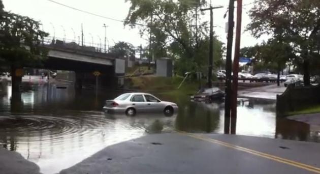 Severe Flooding In The Boston Area
. Check out the
YouTube footage of flooding near the train station in Swampscott, Massachusetts. The northeastern suburbs of Boston saw the heaviest rainfall amounts, as much as 3-5" early Tuesday.
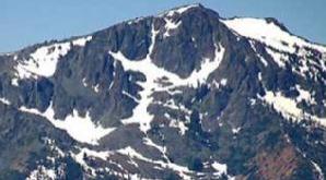 Winter Returns To The Sierra, Snow Above 6,000 Feet. Some meteorologists are calling this the earlier arrival of wintry weather for parts of the western USA since 1969. KTVU-TV in the San Francisco bay area has more information: "SAN FRANCISCO -- A cold weather front took aim at Northern California Tuesday, packing a potent punch with as much as 10 inches of snow for the Sierra peaks, the earliest return of winter conditions to Tahoe since 1969, according to weather forecasters. According to the Central Sierra Snow Lab, the flurries predicted with this storm will make the shortest duration between snow storms since 1969. The lab – located in Norden – got its last measurable snow on July 1 – 96 days ago.The National Weather Service issued a winter storm warning for the Sierra in advance of the storm. The forecasters predicted 5-10 inches of snow above 6,000 feet with winds gusting to 50 mph below the mountain ridges.At lake level in Tahoe, the forecasters warned residents to be ready for several inches of slushy snow.Temperatures were expected to drop 15 to 25 degrees when the heart of the storm crosses over the northern half of the state early Wednesday. "It's unusual for fall. This is more typical of a winter storm," said Steve Anderson, a National Weather Service meteorologist in Monterey. "On average, heavy rain doesn't typically start until the end of October in Northern California. So we're a few weeks early
."
Stress, Anxiety Persist Long After Tornado Tore Through North Minneapolis. The
Star Tribune has the story: "
Four months after a powerful tornado ripped through north Minneapolis, mental health specialists say they are still seeing the storm's aftershocks in residents suffering from despondency, sleeplessness, flashbacks -- even anxious glances out the window any time clouds start forming. "As soon as it rains, you hear, 'Oh, Mom, there's a tornado coming,'" said Ann Sparks, a clinical psychologist who works at NorthPoint Health & Wellness Center. "I think a lot of people are fighting depression," said Joyce Roufs, 81, a lifelong resident of the city's North Side whose block was devastated by the May 22 tornado, the worst to hit Minneapolis in 30 years. It killed two people, injured 50 and damaged hundreds of buildings and many trees. With many residents still displaced and numerous homes still in disrepair, Hennepin County, Minneapolis, the public schools and the Northside Community Response Team coalition are working together to provide help for those feeling depressed and disoriented."
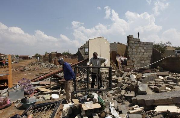
South African Tornado Kills 2, Leaves Thousands Homeless. This was apparently no garden-variety twister that hit South Africa. The
L.A. Times has more details: "
The tornado that hit the township of Duduza on Sunday looked like a gigantic snake with huge eyes, one witness said. Another resident said he thought it was the end of the world, the South African Press Association reported Monday. An 8-year-old child died and more than 160 people were injured when the twister struck Duduza, about 40 miles east of Johannesburg, destroying dozens of houses, many of them tin shacks, according to the Ekurhuleni municipality. Another tornado Sunday killed a 9-year-old in a shantytown near the town of Ficksburg in the Free State, 185 miles south of Johannesburg. More than 40 people were hurt and more than 1,000 shacks and houses were flattened. "I saw the heavens open and I thought that this is Armageddon," Duduza resident Doctor Maseko told SAPA. "I was thrown out of my bed and my electricity blew. Before I knew it, my roof had flown away and I was looking up at the sky."
Remnants Of Hurricane Ophelia Due To Hit Northern Ireland This Week. I thought this was interesting - after battering the Canadian Maritimes, the swirl of moisture leftover from Ophelia is aimed at the British Isles. Here's the latest from the
BBC: "
So what do hurricanes and Northern Ireland have in common? More than many might think it turns out. Last month, the tail end of Hurricane Katia caused damage bringing peak winds of nearly 80mph to Malin Head in Inishowen and Castlederg in County Tyrone. This week, Ophelia is whipping up a storm, and is due to hit Northern Ireland by the middle of the week. However in Ophelia's case, the winds are likely to be in the range of 50-60mph. It may have been downgraded, but forecasters are predicting powerful wind and rain in the north-east of America before it reaches here. Although Northern Ireland managed to escape relatively lightly with Katia, Ophelia's category of wind can bring widespread damage to trees, dislodge slates from buildings and cause minor structural damage."
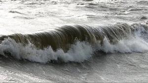 Four-Story Waves Off The British Isles
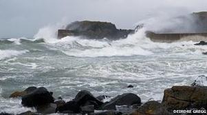
. The BBC reports on 15 meter waves, roughly 49 foot high crests, measured by buoys offshore: "
The rollers of more than 15m (49ft) occurred during gales on Monday. They were measured by devices called wave rider buoys, that were installed off north west Lewis as part of a renewable energy project. Lews Castle College UHI, which is involved in the project, said the waves came as winds peaked at 66mph (106 km/h). The buoys, part of the Hebridean Marine Energy Futures scheme, recorded the waves about five nautical miles off Lewis. Lews Castle College UHI said it was the first time giant waves have been accurately recorded off the Western Isles. Project leader Arne Vogler said: "The occurrence of 15m waves - the height of a four-story building - after half-a-day of severe gale force winds indicates that much higher waves are likely to occur during prolonged storm periods which are often encountered in the area between autumn and spring."
Hurricane Season Is Past Peak (But Stay On Guard). The best odds of a hurricane striking the U.S. mainland? September 10. The risk of hurricanes drops off during the month of October (as a southward shift in the jet stream helps to nudge these ocean-forming storms out to sea). But hurricanes have been observed every month of the year.
Our Amazing Planet has more on the 2011 hurricane season: "
This year's active hurricane season, already impressive in its activity, still has two months remaining. As Ophelia withers, the season seems to have hit another lull. Are we past the peak of the season? "From a climatological standpoint, about 75-80 percent of all hurricane activity has occurred," said Phil Klotzback, a hurricane forecaster at Colorado State University in Fort Collins. "So, yes, we are past the peak of the season." Ophelia was the 15th named storm of the 2011 season, followed by number 16, Tropical Storm Phillipe, which is still swirling over the open Atlantic basin. The 2011 season was predicted to be a doozy, with 14 to 19 named storms (which include tropical storms and hurricanes), seven to 10 hurricanes and three to five major hurricanes(Category 3 or higher). So far, there have been 16 named storms, four hurricanes (Irene, Katia, Maria and Ophelia) and three major hurricanes (Irene, Katia and Ophelia). But just because the season is past its peak is no reason to let down your guard. Hurricane season isn't officially over until Nov. 30, and deadly hurricanes can strike at any time through then, and even after. The tropics could heat up in these final months as storms shift their birthplace to the west in the Atlantic basin."
Thailand's "Worst" Floods Leave 224 Dead. The story from
AFP: "
BANGKOK — Thailand's worst monsoon floods in decades have killed 224 people and affected three quarters of the country, including part of the ancient city of Ayutthaya, officials said Tuesday. Authorities were meanwhile battling to stop the floods reaching the centre of low-lying Bangkok, as forecasters warned of more wild weather to come. "It's the worst flooding yet in terms of the amount of water and people affected," said an official at the Department of Disaster Prevention and Mitigation who preferred not to be named. Two months of flooding have inundated 58 of 77 provinces -- with 25 still severely affected -- and damaged the homes or livelihoods of millions of people, according to the government. Wat Chaiwatthanaram, one of Ayutthaya's best-known temples, has been closed to visitors after a makeshift dyke was breached at the former capital, a popular tourist destination north of Bangkok. "The water level inside the temple grounds is now 1.50 metres (five feet)," said Supoj Prommanoch, head of the Fine Arts Office in Ayutthaya. He said 10 other temples were also flooded but the authorities were confident they could prevent the waters from reaching Ayutthaya's main World Heritage Park, which is located further away from Chao Phraya River."
2011 Sets New Record For Federal Disaster Declarations. The
Insurance Journal has the story: "
The year 2011 will go down as a record-setting year when it comes to federal disaster declarations, industry analysts say. With another three months left in 2011, and hurricane season continues until November 30, the number of federal disaster declarations already exceeds 2010’s record, according to the Insurance Information Institute. “The federal government issued 86 disaster declarations as of September 30, breaking the previous annual U.S. record total of 81, which was set just last year,” said Dr. Robert Hartwig, an economist and president of the I.I.I. “The number of U.S. disaster declarations has been trending sharply upward, particularly over the past 15 years,” he said. The average number of disaster declarations between 1953 and 2010 was 34 per year. “We’re likely to see nearly three times that many by year-end 2011,” Hartwig said, noting that the increase in recent years was due both to growth in the actual number of catastrophes, as well as to an apparent increase in the propensity to issue federal disaster declarations. Federal disaster declarations make federal funding available for emergency recovery efforts to support state, tribal, territorial and local communities. These funds supplement monies already allocated by private-sector insurers, other governments, and private nonprofit organizations."
FEMA Aid A Disaster In The Making? Philly.com has the story: "
In the aftermath of Irene and Lee, a tide of federal generosity has washed across the region. For the first time since 1965, residents of Philadelphia and the seven surrounding counties in Pennsylvania and New Jersey are eligible for disaster aid from Washington. The Federal Emergency Management Agency has worked diligently to encourage people to apply for the assistance, and more than 35,000 in the region have. FEMA is operating recovery centers seven days a week from West Chester to Philadelphia to Pennsauken. As of Friday, the agency had committed $350 million for the two storms in New Jersey and Pennsylvania. Delaware was added to the eligible list late Friday. But in a year that already has set a national record for presidential disaster declarations, whatever is spent around here will be just so many drops in a rapidly filling bucket. Allowing that the national heart is in the right place, some economists and risk experts wonder whether the nation is spending its way toward a disaster of another type - financial. They wonder whether the nation is developing a FEMA dependency. The $80 billion in FEMA aid over the last decade is more than quadruple the amount doled out in the 1960s, adjusted for inflation."
Updraft in Airline Cancellations. Have you noticed more cancelled flights lately? It's not your imagination. The combination of more weather extremes (and new airline policies) is increasing the odds of flights never leaving the ground. The
Pittsburgh Post Gazette has the story: "
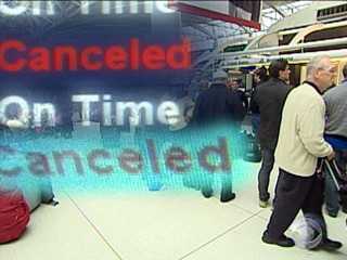
ATLANTA -- U.S. airlines are canceling flights at the fastest clip in a decade as storms from blizzards to hurricanes wallop the busiest hubs, and full planes are making it harder for stranded travelers to rebook trips. United Continental Holdings, Delta Air Lines and other large carriers have scrubbed almost 104,000 flights this year through Sept. 21, or 2.36 percent of the scheduled total. A full-year rate at that level would be the highest since 2001, according to the federal Bureau of Transportation Statistics. The disruptions stem from a combination of foul weather in major markets such as New York City and seating-capacity cutbacks to curb costs. When Hurricane Irene struck the East Coast in August, Cameron McCulloch faced a weeklong wait for a new ticket -- so he drove the 3,000 miles from Seattle to Yale University to catch the start of classes. "There was too much uncertainty with the flights," said Mr. McCulloch, 21, a Yale junior. "At least with driving I knew I'd be there on time and that I could control all the factors." Annual cancellations have exceeded 2 percent just six times in 24 years of federal recordkeeping. Researcher FlightStats.com computed the 2011 year-to-date figure for Bloomberg, using data reported by airlines. The transportation statistics bureau won't disclose its September figures until November." (photo above courtesy of CNET.com).
Got The Internet? Then Never Leave Home Again. Here is some fascinating information (and a compelling "infographic" that helps to tell the story) from
makeuseof.com about how you can do just about anything (and everything) from the comfort of your home - all you need is high-speed Internet: "
I’m sure, being the Internet-savvy users that you all are, that a lot of your life is online. You order your books and music through Amazon, you order takeaway pizza with your iPhone, you rent movies through your media center, you Google your medical symptoms, you pay your bills with online banking and you order your groceries through supermarket websites. In short, you can do pretty much anything online these days so the number of reasons for leaving your home start to diminish. Sad? Well that depends on your point of view and priorities. Our infographic today comes from College At Home
and shows all the different things you can do online which allows you to never leave your home. The one that I most identify with is telecommuting. I work from home online full time and if it wasn’t for the Internet, I wouldn’t have the best job of my life. Here in Germany, my father-in-law also telecommuted but it took many years and much form filling to get the powers-that-be to agree to it. It seems that the situation is no different elsewhere in the world where employers resist the very idea of their employees working from home naked."
 New iPhone 4S Details
. O.K. I'm an Apple fanboy. Sorry, I tried Android but the app marketplace was a nightmare - I
just like the iExperience more than the wild-wild-west approach to Android.
Gizmodo.com has more details on yesterday's new iPhone launch:
• CPU and graphics: The iPhone 4S now has the iPad 2's dual-core A5 CPU. It also has dual-core graphics, which will allow for faster and more detailed 3D. Apple claims this hardware combination makes the iPhone 4S seven times as fast as the iPhone 4 on games, and two times as fast on normal tasks.
• Internet speed: Like rumored, the new iPhone 4S runs on faster HSPA+ networks. That means that your telephone will download stuff faster from the Internet. Before it was up to 7.2 Megabits-per-second downloads. Now they claim two times as much: 14.4Mbps. This depends on the carrier, of course. I don't know about you, but on AT&T I never get the maximum speed they claim.
Apple claims that, in real life situations, they are fast or "faster" as the competition's phone on faster 4G networks. We will test that claim.
TOTO "Toilet Trike" Takes To Japan's Streets. Just when you think you've seen everything, along comes this article at
gizmag.com: "
If you think this smells like a PR stunt, you're right. In an effort to raise awareness about bathroom emissions and water savings, Japanese toilet manufacturer TOTO has created the Toilet Bike Neo Project ... yep, it's a road-going, three-wheeled toilet fueled by "biogas" generated from the toilet waste. The toilet trike will hit the Japanese roads in the coming days, making its way from Kyushu to Tokyo with many press stops along the way. And as if having a toilet as the rider's seat isn't enough to attract attention, the bike also features an LED lamp mounted on a column at the rear which is used to create the impression of a floating message as the bike zooms past. The rider will also be able to keep informed of the latest stock prices or weather reports as this toilet talks."

 Paul's Conservation Minnesota Outlook for the Twin Cities and all of Minnesota:
TODAY: Hot sun. Record is 86 (1912). Winds: S 10-20. High: 87
WEDNESDAY NIGHT: Clear and mild. Low: 58
THURSDAY: Plenty of sun, still August-like. High: 81
FRIDAY: Clouds increase - very windy, showers possible western Minnesota. Low: 60. High: 82
SATURDAY: Balmy, stray T-shower possible (probably the drier/milder day of the weekend). Low: 63. High: near 80
SUNDAY: Better chance of showers, even a T-storm. Low: 62. High: 74
MONDAY: Partly sunny, drier day. Low: 57. High: 73
TUESDAY: More clouds, breezy and cooler. Low: 55. High: 66
October Hot Front
Governor Dayton should sign an Executive Decree, giving ALL of us the day off; a well-deserved mental health day. Why? There's a good chance we'll tie or even break today's all-time record high (86 in 1912). 90 isn't out of the question close to home. Not bad, considering the sun is as high in the sky as it was in early March, with only 11 hours, 29 minutes of daylight. We've lost nearly 4 hours of daylight since June 21.
How unusual is this? According to Pete Boulay at the State Climate Office the average date of the last 80-degree temperature at MSP is October 1.
The first big winter storm of the season will dump 1-2 feet of snow from the Sierra Nevada into Colorado's San Juan mountains. We stay on the warm side of this massive storm through the weekend, with a growing chance of showers late Saturday and Sunday. Long range models keep highs in the 60s to near 70 through October 20. The blog has more details on the wettest September for North America since 1999; 4th warmest in 50 years. Also, an "Antarctic-size" ozone hole reported over the northern hemisphere earlier this year, according to Canadian scientists.
No gloom and doom today: shorts on October 5th? Soak it up!
Who's Bankrolling The Climate Change Deniers? A thorough and comprehensive article from
Time Magazine, attempting to connect the dots. There's an awful lot of (energy) money more than content to continue with the status quo: "
Not too long ago, belief in climate science wasn't a political issue. Honestly! As recently as the 2008 U.S. presidential election, both the Democratic and Republican candidates professed belief in the threat of global warming, and each advanced policies designed to curb U.S. carbon emissions. Senator John McCain had even co-sponsored one of the first congressional bills to create a carbon cap-and-trade system. And it wasn't just McCain; Mitt Romney, runner-up for the GOP nomination last time around, supported a regional cap-and-trade program while he was governor of Massachusetts. There was still a wide gap between Democrats and Republicans on the severity of the climate-change threat and on how ambitious carbon-cutting policy should be, but at least there was a general agreement that global warming was a real thing. Not anymore. With the exception of Jon Huntsman — who barely registers in polls — you can't find a Republican presidential candidate who unequivocally believes in climate science, let alone one who wants to do anything about it. Instead of McCain — who has walked back his own climate-policy realism since the 2008 elections — we have Texas Governor Rick Perry, who told voters in New Hampshire over the weekend that "I don't believe manmade global warming is settled in science enough." And many Republicans agree with him: the percentage of self-identified Republicans or conservatives answering yes to the question of whether the effects of global warming were already being felt fell to 30% or less in 2010, down from 50% in 2007-08. Meanwhile, liberals and Democrats remained around 70% or more."
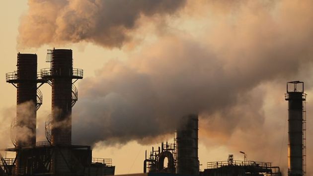 The Inconvenient Facts
. Here's an Op-Ed from a former Republican Congressman from South Carolina, which originally appeared in Bloomberg News, reprinted at
timesunion.com: "
Normally, the country can count on conservatives to deal in facts. We base policies on science, not sentiment. We insist on people being accountable for their actions. And we maintain that markets, not mandates, are the path to prosperity. When it comes to energy and climate, these are not normal times. We're following sentiment, not science, we're turning a blind eye to accountability, and we're failing to use the power of markets. The National Academy of Sciences says, "Climate change is occurring, is caused largely by human activities, and poses significant risks." Several recent studies have found that 95 percent of climate scientists are convinced that the planet is rapidly warming as a result of human activity. But a George Mason University-Yale University poll in May found that only 13 percent of the public realizes that scientists have come to that conclusion."
Group Urges Research Into Aggressive Efforts To Fight Climate Change. Details from the
New York Times: "
With political action on curbing greenhouse gases stalled, a bipartisan panel of scientists, former government officials and national security experts is recommending that the government begin researching a radical fix: directly manipulating the Earth’s climate to lower the temperature. Members said they hoped that such extreme engineering techniques, which include scattering particles in the air to mimic the cooling effect of volcanoes or stationing orbiting mirrors in space to reflect sunlight, would never be needed. But in its report, to be released on Tuesday, the panel said it is time to begin researching and testing such ideas in case “the climate system reaches a ‘tipping point’ and swift remedial action is required.” The 18-member panel was convened by the Bipartisan Policy Center, a research organization based in Washington founded by four senators — Democrats and Republicans — to offer policy advice to the government. In interviews, some of the panel members said they hoped that the mere discussion of such drastic steps would jolt the public and policy makers into meaningful action in reducing greenhouse gas emissions, which they called the highest priority. The idea of engineering the planet is “fundamentally shocking,” David Keith, an energy expert at Harvard and the University of Calgary and a member of the panel, said. “It should be shocking.”













No comments:
Post a Comment