63 F. average high for October 5.
Paul's Conservation Minnesota Outlook for the Twin Cities and all of Minnesota:
TODAY: Red Flag Warning - high threat of brushfires. Plenty of sun, windy - still unseasonably warm. Winds: S 15-30. High: 82
THURSDAY NIGHT: Patchy clouds, still mild. Low: 60
FRIDAY: More clouds, stray shower possible - very windy. Winds: S 20-40. High: near 80
SATURDAY: Unsettled, slight shower chance. Low: 63. High: 76
SUNDAY: Lingering showers, turning a bit cooler (best chance of rain south/east of MSP). Low: 60. High: 72
MONDAY: More clouds than sun. Low: 58. High: 72
TUESDAY: Mostly cloudy, still milder than average. Low: 57. High: 71
WEDNESDAY: Cooler, better chance of showers. Low: 55. High: 65
Number of Days Above 80 In October at MSP:
4 days: 2010, *2011
3 days: 2007, 2006, 2003
2 days: 2005
1 day: 2001, 2000
10 days: 1953 (all-time record, according to Pete Boulay at the State Climate Office).
* a total of 17 days above 80 in October since 2000, according to friend and meteorologist Dan Lilledahl, a Minnesota transplant now living in Atlanta. Thanks Dan!
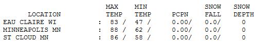
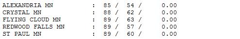
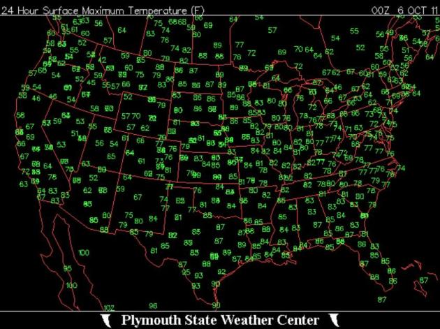
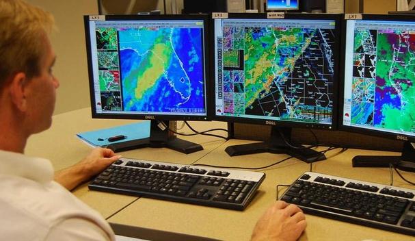
Upside Down Weather Map. Let me get this straight: on Wednesday it was hotter in the Twin Cities of Minnesota (88) than Phoenix (85), Dallas (87), even Miami (86)?? Record warmth continues over the nation's midsection, while New England experiences cool 50s and 60s, and much of the west experiences the first wintry cold front (and heavy snow) of the season. Map courtesy of the Plymouth State Weather Center.
URGENT - FIRE WEATHER MESSAGE
NATIONAL WEATHER SERVICE TWIN CITIES/CHANHASSEN MN
708 PM CDT WED OCT 5 2011
...STRONG WINDS AND LOW AFTERNOON HUMIDITY WILL CONTINUE ONCE AGAIN THURSDAY AFTERNOON...
...STRONG WINDS WILL CONTINUE INTO SATURDAY...BUT WITH A SLOW RISE IN HUMIDITY...
.THE RED FLAG WARNING WILL REMAIN IN EFFECT ACROSS MOST OF CENTRAL AND SOUTHERN MINNESOTA THROUGH 7 PM THURSDAY. THE WARNING INCLUDES SUCH AREAS AS THE MINNESOTA RIVER VALLEY...AND CARLOS AVERY AND SHERBURNE NATIONAL WILDLIFE REFUGES. ALSO INCLUDED ARE THE COMMUNITIES OF ALBERT LEA...ALEXANDRIA...MANKATO...MORA...ST CLOUD...WILLMAR...AND MUCH OF THE TWIN CITIES METROPOLITAN AREA.
RED FLAG CONDITIONS WILL RESUME AGAIN THURSDAY AFTERNOON OVER CENTRAL AND SOUTHERN MINNESOTA. SOUTHERLY WINDS WILL INCREASE TO OVER 20 MILES AN HOUR WITH GUSTS OVER 30 MILES AN HOUR AT TIMES...ESPECIALLY OVER WEST CENTRAL MINNESOTA. WINDS ACROSS THE REMAINDER OF SOUTHERN AND CENTRAL MINNESOTA WILL REACH SPEED OF 15 TO 20 MPH WITH HIGHER GUSTS.
FRIDAY WILL BRING ANOTHER DAY OF STRONG WINDS AHEAD OF AN APPROACHING COLD FRONT. IT IS POSSIBLE THAT RED FLAG WARNINGS MAY NEED TO BE CONTINUED INTO FRIDAY. A COLD FRONT WILL PASS ACROSS THE AREA DURING THE DAY SATURDAY WHICH COULD BRING A FEW SHOWERS.
SOUTH WINDS WILL REMAIN GUSTY AHEAD OF THE FRONT WITH WINDS BECOMING WEST AS THE FRONT PASSES. GRASSES..BRUSH AND CROPS ARE DRY ACROSS SOUTHERN AND CENTRAL MINNESOTA AND FIRES COULD SPREAD QUICKLY UNDER THESE CONDITIONS.
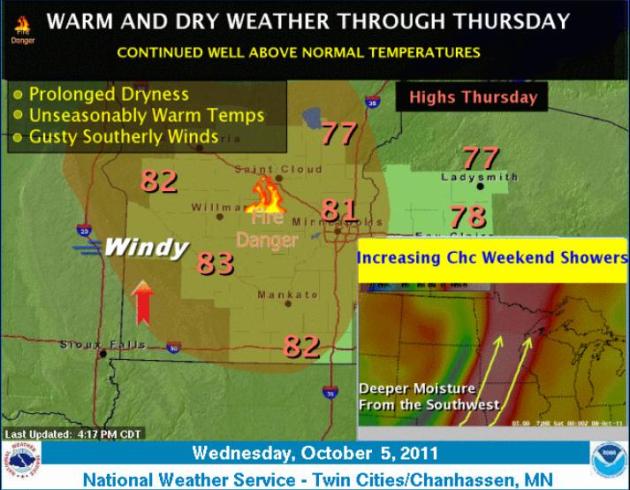
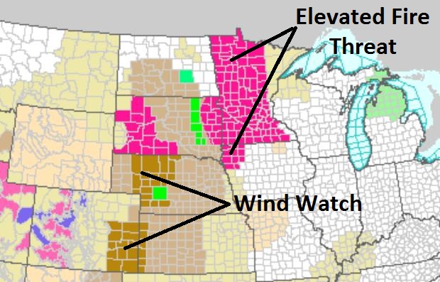
High Brushfire Potential. With gusty winds, bright sun and tinder-dry relative humidity levels - conditions are ripe for fires, wildfires capable of spreading rapidly once underway. The only good news: dew points and humidity levels begin to rise later today into Friday - more water in the air lessening the risk (slightly). The bad news: Friday winds may gust to 30, even 35 mph from the south. More from the local NWS here.

* A cold weather front took aim at Northern California Tuesday, packing a potent punch with as much as 10 inches of snow for the Sierra peaks, the earliest return of winter conditions to Tahoe since 1969, according to weather forecasters. According to the Central Sierra Snow Lab, the flurries predicted with this storm will make the shortest duration between snow storms since 1969. The lab – located in Norden – got its last measurable snow on July 1 – 96 days ago. - KTVU-TV
* Charleston and Columbia, SC (51F and 40F), Jacksonville and Gainesville, FL(46F and 47F), and parts of Arkansas all reported record lows in the past two days.
* On the other hand, parts of the northern US are experiencing record highs. Grand Forks, ND reported a record high of 83F, International Falls (82F), Marquette,MI (76), Chyenne, WY(88F), Dickinson, ND (95F) and many others reported record highs in the last 48 hours.
* 1.15" rain in Los Angeles Wednesday, breaking the old 24 hour rainfall record for October 5 (.61" in 1916).
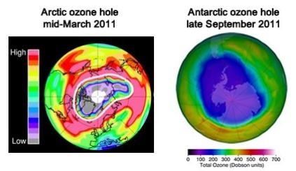
"...According to research published in the journal Nature this week, the largest ozone “hole” on record above the Arctic opened up last winter, exposing residents of the Far North to high doses of harmful ultraviolet (UV) radiation, which can cause skin cancer and cataracts. The area of severe ozone loss extended southward from the Arctic to cover populated areas in northern Russia, Greenland and Norway." - story below on record ozone depletion over the northern hemisphere last winter in the Washington Post's Capital Weather Gang.

5-Day Projected Rainfall. Significant rain is forecast for the central and southern Plains (including the Texas Panhandle!) Note the rainy bullseye over Florida - long range weather models trying to spin up some sort of tropical wave or depression. I would not be surprised to see a tropical storm form in the Gulf of Mexico - or possibly off the east coast of Florida by early next week.
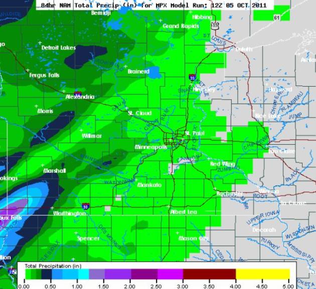
Meager Rainfall Amounts. The latest NAM/WRF model prints out some 1-1.5" rainfall amounts for far southwestern Minnesota, south/west of Marshall, but most of the state is forecast to pick up less than .10" through the weekend. The drought is going to get worse before conditions improve - hopefully before the flakes begin to fly.
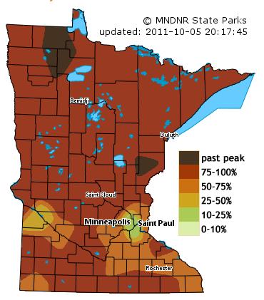
- September 2011 was an exceptionally dry month across Minnesota. This marked the second consecutive month of widespread rainfall shortfalls. In numerous locales, it was the driest September in the modern record.
- Significant rainfall shortfalls have been reported across Minnesota over the past two and one-half months. When compared with the same ten-week period in the historical database, the 2011 precipitation totals rank among the lowest on record.
- Topsoil moisture across 54 percent of Minnesota's landscape is considered to be "Short" or "Very Short".
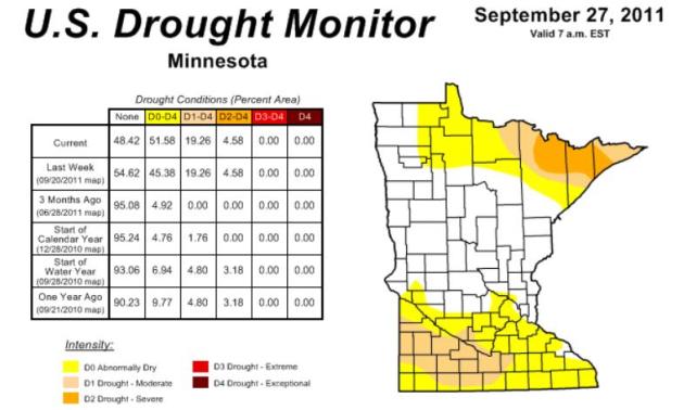
- The U. S. Drought Monitor, released on September 29 depicts many counties in both southern and northern Minnesota as experiencing drought conditions. Portions of St. Louis, Lake, and Cook counties are said to be undergoing "Severe Drought" or "Moderate Drought". A large portion of south central and southwest Minnesota is placed the "Moderate Drought" category.
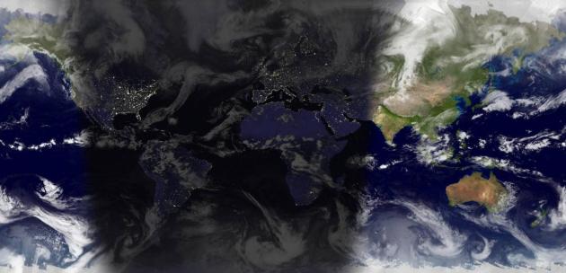
Link Of The Day. This is pretty cool - a web site that shows which part of the planet is in daylight or darkness. Kudos to opentopia.com.

Steve Jobs: 1955-2011. The coverage of Steve Jobs' death last night was borderline bizarre - it almost seemed like a live, televised wake. There were comparisons to Thomas Edison, which seemed more than appropriate, considering Steve's 300 patents. Both my boys called me last night to check in and make sure I was OK; they knew how much I idolized this guy, what an inspiration he was to so many aspiring businesspeople. Jobs was (in my humble opinion) the definition of everything that is right with this country, what one genius can do when he surrounds himself with amazingly smart people and sells them on his vision.
I can't think of an individual who has done more to mold tastes and kickstart innovation in global consumer electronics than Steve Jobs. From computing to music to movies to the iPhone, which is so much more than a "phone" - it's a pocket-size GPS-enabled, photo/video global communicator - he knew what we wanted even before we did. Around the world, many people equated USA = Apple = Cool. He may have been our most important ambassador. Every entrepreneur looked up to him - he defined passion and fighting for what you truly believe in. Steve Jobs made it cool to dream. He turned Apple around when the company was weeks away from bankruptcy. He proved the skeptics wrong time and time again. Most important for kids of all ages....Steve Jobs made it OK to dream big dreams. He proved there is still magic in the world.
A Little Too Nice?
"Paul, you've been standing too close to the Doppler - how can the weather be too nice?" It's too dry out there, too sunny, too windy, relative humidity levels too low - resulting in an enhanced risk of wildfires. "Red Flag Warnings" are rare in the Twin Cities, much more likely in Denver, Dallas or southern California.
In the 1800s nothing struck fear in the heart of Minnesotans more than fire. Tornadoes, floods, blizzards were bad enough, but wildfires elicited a sense of dread...and respect. Survivors used nearby lakes as a refuge of last resort; in some cases they would soak burlap bags and hide in the basements, praying the flames would pass over them.
We've come a long way in being able to track and fight fires, but the threat remains. The Forestry Service reports a 4X spike in western wildfires since 1970.
Our peak fire risk comes Friday, with winds in the 20-40 mph range. A few light showers are possible late week; not enough to ease the fire risk, or growing drought statewide. I don't see any major storms or heavy rain.
Will a deepening dry rut mean a lower risk of October snow here? Probably. 60s hold into the third week of October. After that all bets are off.
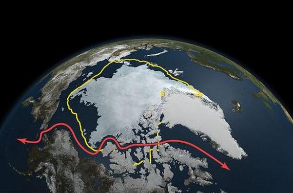
Photo credit above: "Arctic sea ice from March 7 to Sept. 9, 2011, as measured by the Aqua satellite. The yellow line depicts the 30-year average extent of the ice; the red line is the Northwest Passage shipping lane. (NASA)"
Hot To Be The New Normal As Species Struggle. Here's a story from the Sydney Morning Herald: "Soaring temperatures last century may have been hard work for many species across the planet but, by the end of this century, those temperatures, once considered extreme, will become the norm for many of the world's most delicate ecosystems. Research suggests that, over the coming decades, increased temperatures and rainfall will put increased stain on the survival of the Global 200 ecoregions, threatening both plant and animal life. The Global 200 is a set of ecoregions that the World Wildlife Fund (WWF) has classified as having exceptional biodiversity. They contain a high concentration of the earth's species.....Dr Beaumont's study looked at how much climate change is required for monthly temperature and rainfall patterns - which would have been considered "extreme" by 20th-century standards - to become the norm for each of the Global 200 ecoregions."
No comments:
Post a Comment