1.06" rain since September 1 in the Twin Cities.
4.63" rainfall deficit in the metro area since September 1.
Paul's Conservation Minnesota Outlook for the Twin Cities and all of Minnesota:
TODAY: Lot's of sun, windy. Winds: S 15-25. High: 56
FRIDAY NIGHT: Clear and breezy. Low: 40
SATURDAY: Hints of Indian Summer. Sun giving way to increasing clouds. Unseasonably mild Winds: S 20+. High: near 60
SATURDAY NIGHT: Clouding up with a slight chance of a shower. Low: 44
* Don't forget to "fall back" one hour before going to bed Saturday night - as we head back to standard time.
SUNDAY: Gusty, turning cooler. More clouds than sun - chance of a shower (mainly north of MSP). High: 55 (falling)
MONDAY: Sun returns, less wind. Low: 36. High: near 50
TUESDAY: Clouds increase, chance of rain late (mainly southeastern MN). Low: 34. High: 47
WEDNESDAY: Mostly cloudy, best chance of rain (or wet snow) over far southeastern MN. Low: 35. High: 41
THURSDAY: Mix possible early, then gradual clearing. Low: 32. High: 44
60 on Saturday? With a gusty south/southeast wind (15-30 mph) temperatures may be 10-15 degrees above average statewide, 50s statewide, with some low 60s possible south of the Minnesota River. This may wind up being one of the warmer Deer Hunting Openers in recent memory.

Fall Back 1 Hour Saturday Night. Heading back to standard time - an extra hour of sleep this weekend. Woo hoo!
First snow event next week? There's a (slight) chance of wet snow next Wednesday night or Thursday morning - latest models take the storm a little too far south and east for any accumulation in the Twin Cities. But it's still early...
30 and 40-degree highs after November 18 or so, based on GFS model guidance.

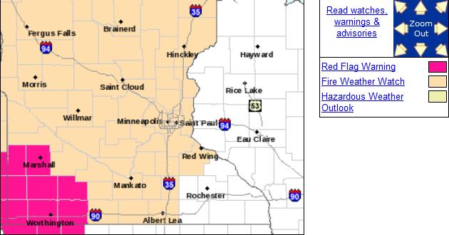
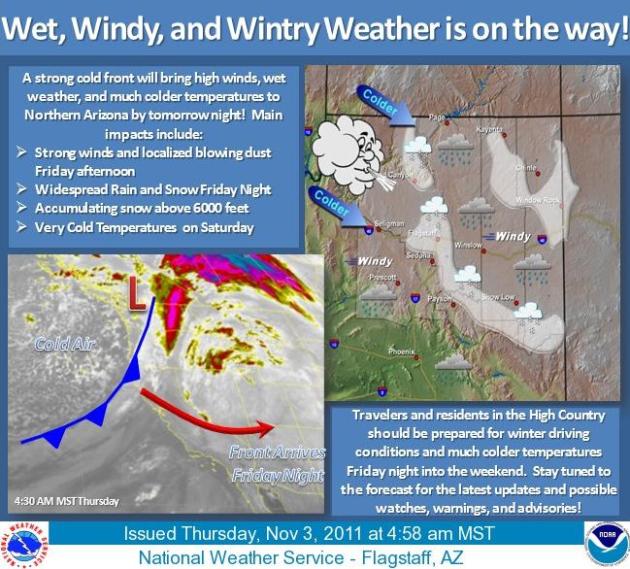
Fire Weather Watch. A watch means conditions are ripe (for brushfire). Red Flag Warnings are in effect for far southwestern Minnesota, where winds will be strongest - meaning a heightened risk of fire. From the local Twin Cities office of the National Weather Service:
......A FIRE WEATHER WATCH IS IN EFFECT FRIDAY AFTERNOON FOR CENTRAL AND MOST OF SOUTHERN MINNESOTA DUE TO THE COMBINATION OF DRY FINE FUELS...STRONG WINDS...AND LOW RELATIVE HUMIDITY VALUES EXPECTED DURING THIS TIME...
MINNESOTA WILL FIND ITSELF IN BETWEEN A STRONG FALL SYSTEM DEVELOPING IN THE ROCKIES AND AN AREA OF HIGH PRESSURE OFF TO THE EAST TOMORROW AFTERNOON. THE RESULT WILL BE STRONG SOUTHERLY WINDS WHICH WILL STRENGTHEN DURING THE LATE MORNING AND CONTINUE THROUGHOUT THE AFTERNOON. SUSTAINED WINDS BETWEEN 15 AND 25 MPH WITH GUSTS OVER 30 MPH ARE EXPECTED ALONG WITH LOW RELATIVE HUMIDITY VALUES BETWEEN 20% AND 30%. FURTHERMORE...MANY LOCATIONS IN MINNESOTA HAVE RECEIVED ONLY AN INCH OR LESS OF RAIN SINCE SEPTEMBER PRODUCING VERY DRY FINE FUELS. DUE TO THE COMBINATION OF THESE FACTORS...A FIRE WEATHER WATCH IS IN EFFECT FOR FRIDAY AFTERNOON IN CENTRAL AND SOUTHERN MINNESOTA. AFTERNOON TEMPERATURES ARE EXPECTED TO ONLY BE IN THE LOWER TO MID 50S WHICH MAY TEMPER FIRE GROWTH POTENTIAL A BIT. HOWEVER...THE STRONG WINDS AND VERY DRY FUELS ARE ENOUGH TO OVERRIDE THE COOL TEMPERATURES.
THE STRONGEST WINDS WILL BE IN WESTERN MINNESOTA.
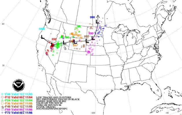
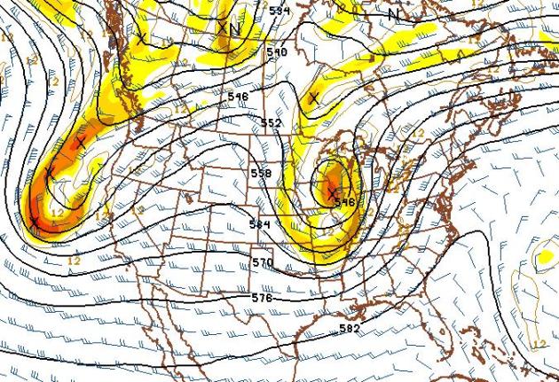
Weekend Storm Track. The heaviest snows usually fall north/west of the storm track. That will mean significant snow for the northern Rockies extending into the western Dakotas. But a south/southeast flow on the east side of the storm track will mean highs in the 50s and 60s as far north as Minnesota and Wisconsin. Map courtesy of NOAA.
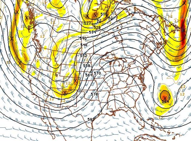
Small Snow Potential Next Wednesday? Here's the latest GFS model, showing an impressive storm tracking south/east of Minnesota the middle of next week, loaded with moisture from the Gulf of Mexico. It's too early for specifics, but I could envision a cold rain mixing with and even changing over to snow by Wednesday of next week, with the best chance of a sloppy mix coming south and east of MSP. Stay tuned...
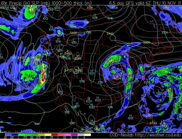
Surface Map: Next Wednesday Night. The latest models push the storm track farther south and east, just brushing southeastern MN with a cold rain, possibly mixed with wet snow late Wednesday into Thursday morning of next week. Still too early....
Despite a technological revolution that has transformed the ways people communicate in barely a generation, the mechanics of delivering the electricity that powers all those new devices remains fundamentally unchanged. The outages have ignited anger among some utility customers, many of whom also lost power during Hurricane Irene in August. Some are demanding to know why power providers haven’t spent the money or adapted the technology necessary to prevent such problems."
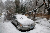
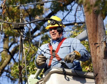
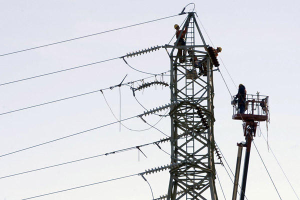
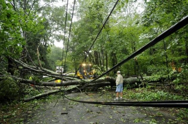
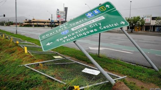
Power Outage Update. Here is a state-by-state look, as of Thursday evening, at some of the effects of the late October storm that shocked the Northeast during the weekend with up to 32 inches of snow. About 675,000 homes and businesses still lacked power, and at least 29 deaths, including one in Canada, were blamed on the storm through traffic accidents, electrocutions or other causes. Information courtesy of Chad Merrill at Earth Networks:
CONNECTICUT
About 426,000 customers without power, down from more than 800,000. At least eight deaths reported.
MASSACHUSETTS
More than 140,000 without power, down from more than 670,000.
NEW HAMPSHIRE
About 20,000 without power, down from 315,000.
NEW JERSEY
About 50,000 without power, down from 700,000.
NEW YORK
More than 18,000 without power Wednesday morning, down from more than 300,000.
PENNSYLVANIA
About 21,000 without power, down from about a half-million. At least eight deaths reported.
* photo above courtesy of the Christian Science Monitor.


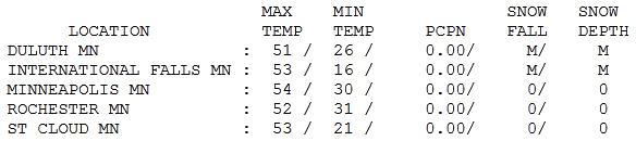

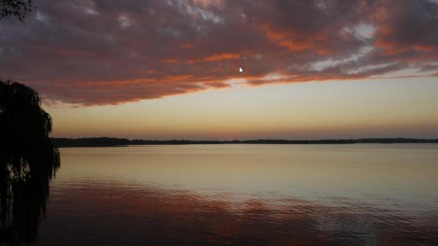
No-Worry November. So far so good - although why do I think we're going to pay for this in a couple weeks? Every day like Thursday is a gift, one less day of grinding, icy commutes and windchill-babble on the radio. Under a perfect blue sky highs ranged from 47 at Alexandria to 53 at St. Cloud, and 54 in the Twin Cities.
Snowy Possibilities
Don't look now, but Minnesota's winters are becoming snowier over time. The Minnesota State Climate Office just released an update, showing a new, 30-year rolling average (1981-2010) of 54" in the Twin Cities. That compares to a long-term, 120-year average of 46.6". It's snowing more, but the snow isn't as predictable as it was in the 70s and early 80s, when snow would reliably be on the ground from late October into early April. Recent winters have seen spasms of snow, followed by rapid melting; with far more rain and ice than a generation ago. Data shows an average of 7.4 "plowable" snows of 2" or more every winter season. We can handle that.
Our first snowfall may come 3-4 weeks later than usual this year (we normally see our first snow flurries around October 16). A southern storm pushes a cold rain into Minnesota late Tuesday of next week, POSSIBLY changing to wet snow by Wednesday. Confidence level is still low on this (potential) storm - It's still way too early for specifics.
No slush for tracking that trophy buck on Saturday, that's for sure. It may feel more like late September out there Saturday afternoon. The sun will be out, highs in the 50s, winds gusting to 30 increasing the risk of brushfires. Sunday looks windy and cooler with showers, especially north of the metro area. Cooler air arrives next week, snowy possibilities by Wednesday.
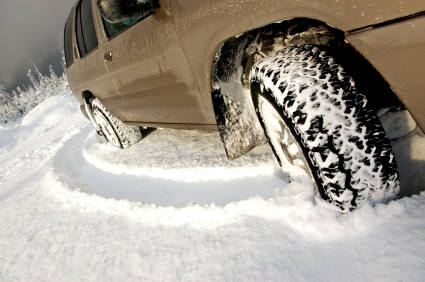
I'm putting my snow tires on, just in case the storm materializes.
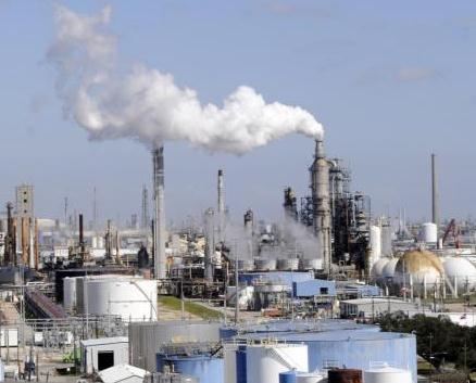
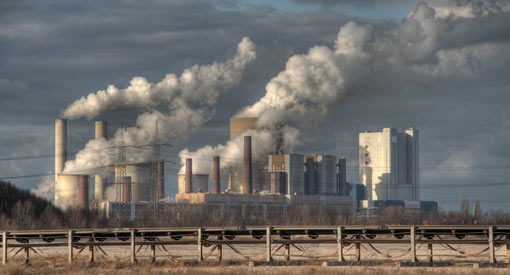
Biggest Jump Ever Seen In Global Warming Gases. The story from USA Today: "WASHINGTON – The global output of heat-trapping carbon dioxide jumped by the biggest amount on record, the U.S. Department of Energy calculated, a sign of how feeble the world's efforts are at slowing man-made global warming. The new figures for 2010 mean that levels of greenhouse gases are higher than the worst case scenario outlined by climate experts just four years ago. "The more we talk about the need to control emissions, the more they are growing," said John Reilly, co-director of MIT's Joint Program on the Science and Policy of Global Change. The world pumped about 564 million more tons (512 million metric tons) of carbon into the air in 2010 than it did in 2009. That's an increase of 6%. That amount of extra pollution eclipses the individual emissions of all but three countries — China, the United States and India, the world's top producers of greenhouse gases. It is a "monster" increase that is unheard of, said Gregg Marland, a professor of geology at Appalachian State University, who has helped calculate Department of Energy figures in the past."
* More on the North Dakota lawsuit from legalnewsline.com.
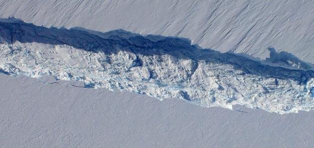
Photo credit above: "A close-up image of the crack spreading across the ice shelf of Pine Island Glacier shows the details of the boulder-like blocks of ice that fell into the rift when it split. For most of the 18-mile stretch of the crack that NASA’s DC-8 flew over on Oct. 26, 2011, it stretched about 240 feet wide, as roughly seen here. The deepest points ranged from about 165 to 190 feet, roughly equal to the top of the ice shelf down to sea level. Scientists expect the crack to propagate and the ice shelf to calve an iceberg of more than 300 square miles in the coming months. This image was captured by the Digital Mapping System (DMS) aboard the DC-8. Credit: NASA/DMS."
No comments:
Post a Comment