0" predicted precipitation over the next 84 hours in the Twin Cities (NAM model). Latest guidance keeps the storm track farther east than previous runs. A little light rain is possible over southeastern MN and western Wisconsin, possibly ending as a few wet snowflakes Wednesday. Little or no precipitation is expected in the Twin Cities.
May 2: last report of a trace of snow flurries in the Twin Cities (MSP International).
Paul's Star Tribune Outlook for the Twin Cities and all of Minnesota:
TODAY: Bright sun, seasonably cool. Winds: W 10-15. High: near 50
MONDAY NIGHT: Clouds increase. Low: 34
TUESDAY: Clouds lower and thicken. A cold rain spreads into far southeastern MN. High: 45
WEDNESDAY: Mostly cloudy, breezy and cool. (Light mix of rain/snow probably stays east over Wisconsin). Low: 33. High: 42
THURSDAY: Clearing, blue sky returns - cooler than average. Low: 27. High: 43
FRIDAY: Lot's of sun, cool and quiet. Low: 29. High: 47
SATURDAY: Plenty of sunshine, light jackets. Low: 34. High: 49
SUNDAY: Dim sun, a few degrees warmer. Low: 35. HIgh: 51
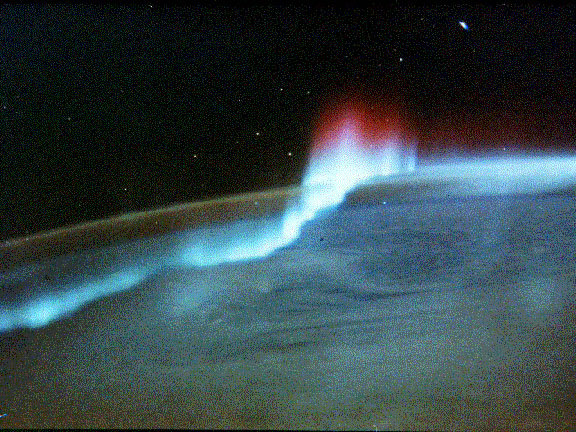
U.S. Anticipates Northern Lights Show This Week. More solar flares are predicted, and that may increase the odds of seeing the Aurora Borealis this week. "Anticipation is mounting that soon the world will be treated to an incredible light show with a sunspot bubbling with activity. Spaceweather.com reports that the unusually large sunspot unleashed at least five M-class solar flares since Saturday and has a “delta-class magnetic field that harbors energy for X-class flares.” Solar flares are ranked by NOAA’s Space Weather Prediction Center (SWPC) based on their x-ray energy output. M-class solar flares are the second strongest with X-class flares sitting at the top of the list. Even if a CME (coronal mass ejection) occurs, it may not head to Earth, as was the case last Thursday. With the sunspot situated on the sun’s outer edge (from Earth’s viewing point), the CME that was unleashed took aim on Mercury and Venus instead." (Aurora photo courtesy of NASA).

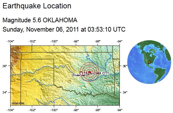
Here’s a rundown of some of the statewide records for Oklahoma so far this year:
Most Snow in a 24 Hour Period: 27 inches Spavinaw, OK Feb 9-10, 2011
Coldest Temperature: -31 degrees Nowata, OK Feb 10, 2011
Largest Hailstone: 6.0 inches 2 miles north of Gotebo May 23, 2011
Highest Wind Speed highest official surface wind measurement (not radar-based) 150.8 mph El Reno May 24, 2011
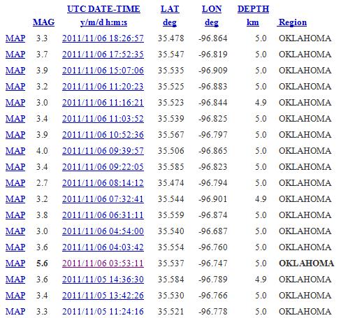
Highest Summer Average Temperature: 86.8 degrees This was also the hottest average summer temperature in history for any state
Warmest August Average Temperature: 87.7 degrees

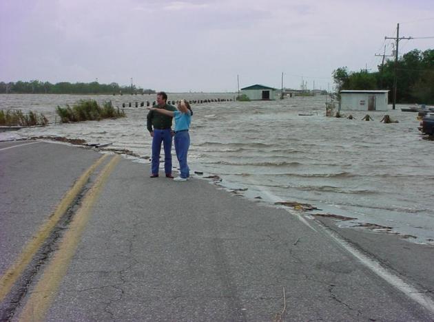
National Hurricane Center Estimates More Than 240 Tropical Systems Were Missed Between 1900 to 2002. Here's another eye-opening article from the Boston Herald: "With less than a month remaining in it, 17 named storms have emerged so far this hurricane season, ensuring this will be one of the most active years on record. Yet five of those storms were so weak that a few decades ago they likely would have been overlooked. Indeed, between 1900 and 2002, the National Hurricane Center estimates, it failed to identify more than 240 systems that might have been tropical storms but were mistakenly deemed too weak or went undetected because they were too far out in the ocean to be studied. Climatologists further guess that of those, 75 were hurricanes. Thanks to the satellite era, which came full force in the mid-1970s, forecasters are able to better estimate the strength of even the most distant systems. In the past 35 years, they have spotted dozens of storms that previously would have been discounted, 18 in the past five years alone." (image above courtesy of NASA).

An emergency preparedness kit should include:
• At least a three-day supply of food and bottled water for each family member;
• Manual can opener;
• Battery-powered radio and flashlights with extra batteries;
• First-aid kit with family members’ medications and prescription information;
• Hygiene and personal care items."
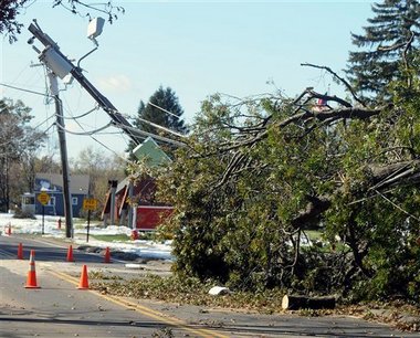
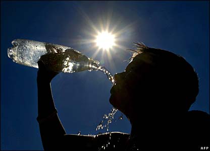
The Troubling Connecticut Power Failure. A foot or two of snow coming in January would be tough enough - but having that amount of heavy, wet snow falling in late October (with most leaves still on the trees) meant that thousands of tree limbs came down onto powerlines, causing the worst outage in the northeast power grid in recent memory. Here's more on the fallout from the October 29 storm from Reuters and The New York Times: "The moneyed folk inhabiting the Connecticut environs of the hedge fund town Greenwich wield plenty of power. But many of them have lately been powerless. For the second time in barely more than two months, a huge swath of the two million captive customers of Northeast Utilities, the power company that covers territory from the Constitution State up through western Massachusetts and into New Hampshire, have spent too many days without electricity. In an echo of the financial crisis, it turns out that better risk management and stronger regulation could have made the fallout much less bad. This raises serious questions about Northeast’s competence — and whether it should be allowed to complete a $4.7 billion takeover of a Massachusetts rival, Nstar." (photo above courtesy of masslive.com).


"Oh wow. Oh wow. Oh wow." Steve Jobs' last words before passing away, according to his sister, Mona Simpson, who was by his side. She recounts the story, and other memories of her brother, in this powerful eulogy in the New York Times.
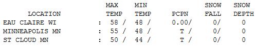
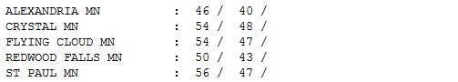
Blustery Sunday. Winds shifted around to the west to southwest, pulling cooler air into Minnesota on Sunday as winds gusted over 30 mph over central and western counties. Daytime highs were still 5-10 degrees warmer than average, ranging from a brisk 46 at Alexandria to 50 at St. Cloud, 55 in the Twin Cities and 58 at Eau Claire, WI.

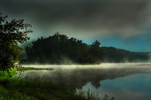
First Flakes for Wisconsin?
"Oh wow. Oh wow. Oh wow." Those were Steve Jobs' last words, according to his sister, Mona Simpson, who was by his side. He fixated on his family before reportedly looking off into the distance and uttering those final words. Jobs was always ambivalent about God and an afterlife, so I find his last words fascinating. Simpson's complete eulogy of his brother is on my blog. That one made me do a double-take.
Shifting gears, 99% of Minnesota is too dry. No more "threat" of a storm or "risk" of rain. We need a good soaking to make up for a 4.75" rainfall deficit since September 1. Give your shrubs, evergreens and newly planted trees a good dousing in the coming days, because I still don't see a real storm for Minnesota. A midweek system may brush far southeastern Minnesota with a cold rain by late Tuesday and Wednesday. A few flakes could mix in over Wisconsin, but the latest NAM model doesn't print out any precipitation for MSP. Not very impressed, although a little slush is possible over central Wisconsin by Wednesday night. Skies clear later in the week, highs near 50 by the weekend with a better chance of rain a week from tomorrow.
No windchill-babble or "plowable" snows looking out 2 weeks. Another tardy, compressed winter? Looking that way. Last year Duluth had already picked up 7.7" snow. So far in '11: a trace at Duluth! No snow at MSP (yet), but that could change on Wednesday. Just enough snow to look out the window and do a double-take.

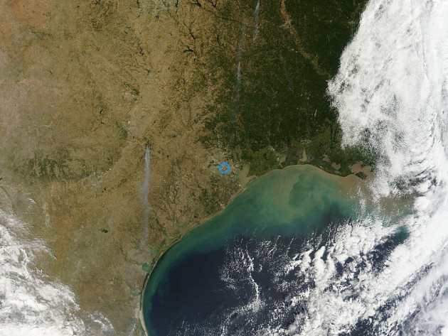
Real Climate Change: From Green To Brown. Here's an Op-Ed from Corpus Christi's caller.com: "For some Americans, climate change is a figment of the overheated imagination of liberal-leaning, pickup truck-hating, CNN-watching, New York Times-reading, Obama- voting, granola-eating scientists. These Americans aren't convinced that there is anything to worry about. Anytime a snowstorm pops up, they ask, where's that global warming? I'm no scientist. In fact, my grasp of the theory of the wheel is a little unsure. But I figure that if a lot of scientists are convinced that there is global warming, and that human activities are contributing to that warming, then the possibility that there is something to the assertion has to be considered. That the Earth is, in fact, warmer is now indisputable fact. Last year tied for the warmest year on record, adding to the recent number of years that rate at or near the top of warm years. Most of the warming has occurred since the 1970s, leading to the not surprising conclusion that human activity has a lot to do with the heating trend. But climate change is one of those issues, like whether Obama's birth certificate is real or whether Al Gore won Florida in 2000, that has more to do with politics than science. That's likely why the TCEQ is likely to shelve a recent scientific report on the health of Galveston Bay which the agency commissioned." (Satellite image courtesy of NASA).
Climate Change Endangering Florida. Theledger.com has an Op-Ed: "I recently returned from a national environmental journalism conference in Miami. It was no accident that climate change and sea level rise were prominent on the agenda. If things continue as predicted, the bottom floors of the hotel where we were meeting would be part of Biscayne Bay — well offshore in Biscayne Bay — by the turn of the century. And even the parts of Dade County that aren't underwater will be uninhabitable because the rising sea level will have made much of the Biscayne Aquifer, the shallow aquifer that supplies drinking water in this part of Florida, too salty to drink. That will force regional water managers to move wells farther inland at great expense to supply water to whatever areas in the region are still habitable. Add to that the fact that substantial portions of South Florida that aren't covered by the advancing sea will be underwater anyway. That's because the canal system that for decades drained subtropical rainfall to the sea will be relatively useless."
No comments:
Post a Comment