"
When in a drought, don't predict rain....or snow." 40.5% of Minnesota is in a moderate/severe drought.
54 F. high Friday (shortly after midnight).
52 F. afternoon high in the Twin Cities.
27 F. high temperature November 25, 2010.
3-4 pm. Rain may change over to wet snow after 3 or 4 pm this afternoon.
7 pm. temperatures are forecast to drop to 32 this evening. Most roads will remain wet in and near the metro area through the dinner hour. Watch bridges and secondary roads later this evening and tonight - a few may become icy.
 .12"
.12" precipitation today (NAM). Much of that will fall as light rain - a coating of slush possible on lawns/fields by evening.
Fourth Warmest Thanksgiving On Record For Twin Cities. From the
MPX office of the NWS: "
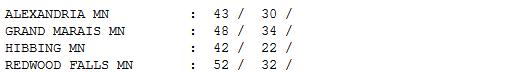
The high yesterday at Minneapolis-St Paul was 59 degrees, tying the record high for November 24, set in 1990. It was also the fourth warmest Thanksgiving in Twin Cities history. The only warmer Thanksgivings have been November 26, 1914 (a high of 62), November 30, 1922 (a high also of 62), and November 30, 1939 (a high of 60). Please see climate.umn.edu/doc/journal/thanksgiving_climatology.htm for more Thanksgiving Day Climatology. The warmest temperature in Minnesota yesterday was 66 near downtown Redwood Falls. The second warmest temperature in the state was 65, at Canby and the Redwood Falls airport."
 Mr. Skilling is apolitical and understands the risks of speaking out on an issue like global warming, but he feels compelled to. “I questioned it, but it’s happening, no doubt,” he said. “The models have said all along that the Arctic latitudes would warm fastest and spark changes throughout the world......“You’d have to have your head buried in the sand not to say there’s something going on. There’s a mosaic of influences, including human effects, and how you rate them is difficult. But it is going on, and we have to study it
.” - from a New York Times article on Tom Skilling below.
 Accumulating Snow Up North
. The Duluth office of the NWS has issued a winter weather advisory for some 2-4" snowfall amounts north of Duluth. Details:
...WINTER WEATHER ADVISORY REMAINS IN EFFECT UNTIL 6 PM CST
SATURDAY...

A WINTER WEATHER ADVISORY REMAINS IN EFFECT UNTIL 6 PM CST
SATURDAY.

* TIMING AND LOCATION: OCCASIONAL LIGHT SNOW AND FREEZING DRIZZLE
  WILL DEVELOP LATE THIS EVENING AND ESPECIALLY AFTER MIDNIGHT
  GENERALLY ALONG AND NORTH OF THE IRON RANGE INCLUDING THE
  ARROWHEAD REGION AND INTERNATIONAL FALLS AREA. THE SNOW AND
  FREEZING DRIZZLE WILL CONTINUE THROUGH SATURDAY MORNING...THEN
  CHANGE OVER TO MAINLY SNOW SATURDAY AFTERNOON.

* SNOW AND ICE ACCUMULATIONS: SNOWFALL AMOUNTS OF 2 TO 4 INCHES
  AND ICE ACCUMULATIONS OF TENTH OF AN INCH OR LESS.

* MAIN IMPACT: THE SNOW AND ICE ACCUMULATION WILL MAKE TRAVELING
  DIFFICULT IF NOT HAZARDOUS.
 Little More Than A Slushy Coating.
 The European ECMWF model was right. By the time northwest winds kick in later today and it's cold enough for snow - most of the moisture will be well east of MSP. The latest NAM model is still suggesting a cold rain changing to wet snow by late afternoon or evening - maybe a coating of slush on lawns and fields. No mega-problems on the highways, and the sun should come out Sunday with highs above freezing - no epic headaches getting home, by car or plane.
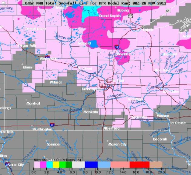
 Plowable Up North?
 The latest NAM model continues to print out some 2-5" snowfall amounts for the Iron Range and Minnesota Arrowhead - subsequent lake effect on the backside of this next storm whipping up some 2-4" amounts for the snow belts of northern Wisconsin. Snowfall amounts in the MSP
metro area should be slim to nil.
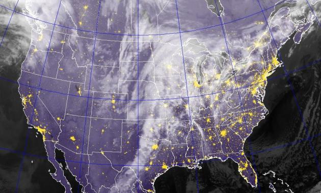 Shifting Gears
. The arrival of seasonably cold air will set off a cold rain changing to snow across the Upper Midwest and Great Lakes later today. Infrared satellite courtesy of the Naval Research Lab.
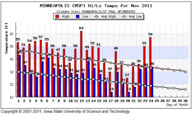
Consistently Warmer Than Average. This graphic from the
Iowa Environmental Mesonet (courtesy of the Iowa State University of Science and Technology) shows the November temperature trend for the Twin Cities. For the month temperatures are running more than 3 degrees above average. 59 F. on Thanksgiving Day is pretty impressive for this latitude.
Warm Thanksgiving Day. Here's a good overview of Thursday's amazing warmth from Mark Seeley in his weekly
WeatherTalk blog: "
November 24th brought the warmest Thanksgiving Day for many Minnesota communities since 1990. Near Redwood Falls the afternoon temperature reached 66 degrees F, just two degrees F shy of the state record for the date (68 F at Wheaton in 1984). But many Minnesota communities reported new record highs yesterday (November 24th) prompting a good deal of outdoor activity for the holiday. Those reporting record highs included: 65 degrees F at Canby; 64 degrees F at Tracy; 61 degrees F at Austin; 60 degrees F at Rochester; 59 degrees F at MSP (tied record); 57 degrees F at Fargo-Moorhead; and 55 degrees F at Detroit Lakes (tied record)."
First Measurable Snowfall Statistics For Chicago and Rockford. From the local NWS office:
CHICAGO...
...122 YEARS OF RECORDS FOR FIRST DATE OF MEASURABLE SNOWFALL.*
...THE AVERAGE DATE OF FIRST MEASURABLE SNOWFALL IS 11/16.
...75 PERCENT OF THE YEARS HAD RECEIVED MEASURABLE SNOWFALL BY 11/25.
...84 PERCENT OF THE YEARS HAD RECEIVED MEASURABLE SNOWFALL BY 12/1.
...EARLIEST DATE OF FIRST MEASURABLE SNOWFALL:10/12/2006.
...LATEST DATE OF FIRST MEASURABLE SNOWFALL:12/16/1965.
LOOKING BACK AT THE 2010-2011 SNOW SEASON...NO MEASURABLE SNOW WAS
RECORDED AT BOTH CHICAGO-O'HARE AND ROCKFORD AIRPORT UNTIL DECEMBER
1ST. IN THE CURRENT FORECAST PERIOD...WET SNOW MAY MIX IN WITH
RAIN SHOWERS LATE SATURDAY NIGHT INTO SUNDAY...BUT NO MEASURABLE
SNOW IS EXPECTED. AFTER THAT...THERE IS A DISTINCT POSSIBILITY
THAT THE FIRST MEASURABLE SNOWFALL OF THE SEASON MAY NOT OCCUR AT
CHICAGO AND ROCKFORD UNTIL AFTER DECEMBER 1ST
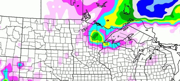
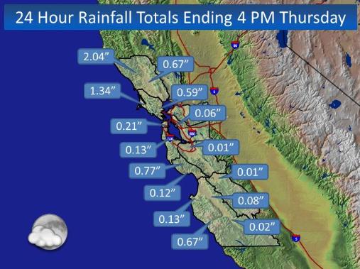
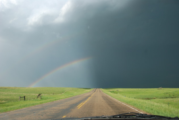
Soggy Pattern For California. I still don't see any significant storms (rain, snow or ice) for the Upper Midwest anytime soon, the core of the jet supressed to the south, favoring storms for the west coast, and parts of the southern and eastern USA. Thanksgiving rainfal amounts above courtesy of the San Francisco National Weather Service office.
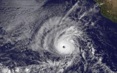
Hurricane Kenneth Sets Record For Eastern Pacific Storms. The
Summit County Citizen's Voice has more on last week's record, Category 4 hurricane in the eastern Pacific: Measuring 300 miles across and generating sustained winds of 145 mph,
Hurricane Kenneth this week set a record as the latest major hurricane in the eastern Pacific Ocean. More hurricane records are
online here. Dr. Jeff Masters, of Weather Underground, also commented on the unusual nature of the 2011 eastern Pacific hurricane season
in his blog. Normally, La Niña conditions in the Pacific suppress the formation of intense hurricanes.
Florida Escapes Hit By Major Hurricane For Another Year. The story from
Tampa Bay Online: "
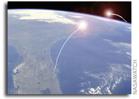
The squiggly lines of storm paths are everywhere – in the Atlantic Ocean and even the Gulf of Mexico. But none, thankfully, crossed the state of Florida. During a busy hurricane season that saw 18 named storms, with seven of those morphing into hurricanes, the Sunshine State was not impacted a single time. "It was an incredibly good year for us," said Michelle Palmer, deputy state meteorologist for Florida. "We like calm seasons." The only names we didn't make it to in the 2011 list were Tammy, Vince and Whitney. And while hurricane season doesn't officially end until Wednesday, forecasters say we have likely seen the last of tropical activity for the year." (Photo courtesy of NASAWatch).
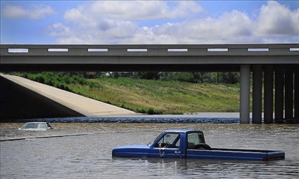
How To Steer Clear Of Flood-Damaged Cars. Looking for a (gently) used car? If you find a deal/price that's too good to be true, check to see if the car or truck was in a flood of any kind. Here's a harrowing story from
The Republic: "
ORLANDO, Fla. — The hurricane season is almost over for 2011, suggesting that we no longer need to worry about one of the major problems caused by severe storms — flooded cars. Right? Wrong. Unscrupulous brokers have learned that it isn’t smart to try to sell flood-damaged cars just down the road from a major flood. It isn’t that hard to do a quick, cursory reconditioning of a damaged car in one place, then ship it — or a whole truckload of poorly reconditioned cars — to another city or state where consumers wouldn’t suspect. Be aware, too, that it doesn’t require a major, news-making flood to cause damage. A neighborhood flash flood can send vehicles with serious water damage onto the market." (photo above courtesy of MSN, which has more good information on spotting flood-damaged vehicles
here).
For (Tom) Skilling, There Is No Such Thing As Bad Weather. Let me tell you a quick story about Chicago TV meteorologist Tom Skilling, one that sheds light on what a great (genuine) guy he really is. When I was a wide-eyed meteorology student at Penn State I dropped by the WGN-TV studios in Chicago for a quick tour. Not only did Tom show me all his meteo-toys at the office, but he took my friend and me to his Chicago townhouse, where he had converted a guest bedroom into a weather center, complete with "NAFAX" maps plastered on every wall. I was in weather-heaven. He was and is the epitome of a weather geek/enthusiast - and I
say that with admiration and genuine respect. Tom is still at the top of his game. He still makes time to get others excited about meteorology. That, and he doesn't take himself too seriously. If I sound like a groupie, well, maybe, in this (rare) instance, I
am. I mean, this guy bought a place in Anchorage so he could be CLOSER TO SNOW! Yes, Tom Skilling is the real deal and it's great to see nice guys (who are passionate about what they do)....do well. The
New York Times agrees that Mr. Skilling is a force of nature: "
There are many reasons for Chicagoans to wonder what in the name of Harry Volkman is going on with their weather. A blizzard in February dumped 21 inches of snow on the city and closed Lake Shore Drive for three days. A heat wave in July delivered the first 100-degree temperatures in six years. Forecasters are warning of arctic-like conditions in the months ahead — it is going to be another brutal winter. To make sense of it, people are turning to Mr. Skilling in ever greater numbers, if 52,000 Facebook fans and 12,000 Twitter followers are any indication. Since Mr. Skilling succeeded Mr. Volkman as WGN’s chief meteorologist in 1978, the folksy, 59-year-old has become the undisputed king of Chicago weather, with a million-dollar salary, a 12-person staff and stature at his station that is unmatched in the market. His amiable, enthusiastic demeanor is a perfect delivery vehicle for the knowledge and passion he brings to his subject."
Is Apple Working On iTV? It's still pure speculation and conjecture at this point, but the Apple fan boys (myself included) are praying that Apple will ultimately improve on the television experience. I found this blurb interesting from
mashable.com:
"Apple’s relationship with Samsung has deteriorated, and the Cupertino giant may be working with Sharp on the next generation displays for upcoming devices such as the iPad 3, iPhone 5 and a little something called iTV, claims Jefferies analyst Peter Misek. Since all of these products are unofficial and unannounced, such predictions fall into the realm of speculation. However, Misek claims that the mythical iTV – a future “smart TV” product from Apple that has been the subject of many recent rumors – is a real thing, and Sharp is working on modified amorphous TFT LCD panels for the device."
 Friday: Transition Day
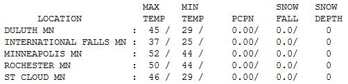
. Not quite as spectacular as Thanksgiving, Friday temperatures were still nearly 20 degrees warmer than average over central and southern Minnesota. Highs ranged from 37 at International Falls to 46 St. Cloud, and 52 in the Twin Cities (afternoon high).
Paul's Conservation Minnesota Outlook for the Twin Cities and all of Minnesota:
TODAY: A cold rain, mixing with wet snow by mid or late afternoon. Gusty, turning colder. Winds: 38 (falling)
SATURDAY NIGHT: A little wet snow, quickly tapering to flurries. A coating of slush possible on lawns/fields. Low: 24
SUNDAY: Slushy/icy start. Slow clearing with some afternoon sun. Feels more like late November. High: 35
MONDAY: Plenty of sun, a bit milder. Low: 25. High: 45
TUESDAY: Clipped again. Gusty and colder with a mix of clouds and sun. Low: 23. High: 34
WEDNESDAY: Sunny start, clouds increase. Low: 23. High: 37
THURSDAY: Storms stays south. Some sun. Low: 22. High: 36
FRIDAY: Chilly start, warming PM hours. Low: 23. High: 39
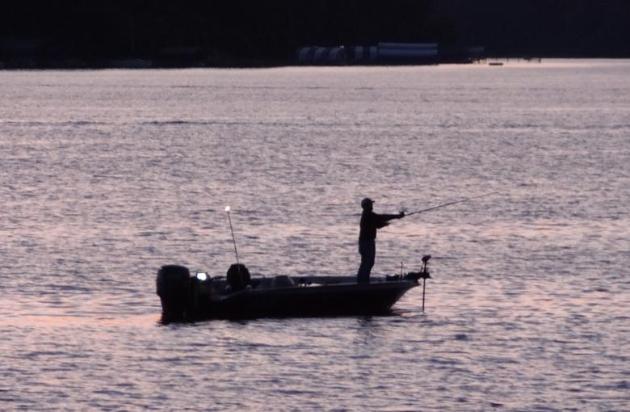
Seasonal Shrinkage
I saw a fishing boat on Lake Minnetonka yesterday. At first I thought I was hallucinating ("did I get some bad turkey or what?") but there it was. For the 10th November in a row: temperatures warm enough to play golf. In Minnesota.
At the risk of sounding like Andy Rooney (God rest his soul), do you remember when it used to snow in October - and snow would (consistently) STAY on the ground through early April? The (new) 30 year snowfall average for MSP insists that our winters are snowier (a whisker under 56" every season). It's snowing more, at least on paper. But it's not sticking around the way it did a generation ago. Winters are warmer, especially at night. We still dip below zero, but not nearly as often as during the 60s and 70s. A bit unsettling.
After the 4th warmest Thanksgiving on record we're due for a reality check. A cold rain today ends as a little wet snow. A coating of slush is possible, enough to shovel/plow near Duluth. We may wake up to a few icy roads Sunday morning, but travel conditions should improve as the day goes on.
Nothing has changed; storms detour well south/east of Minnesota. 40% of our state is in a moderate/severe drought; and it's about to get worse.
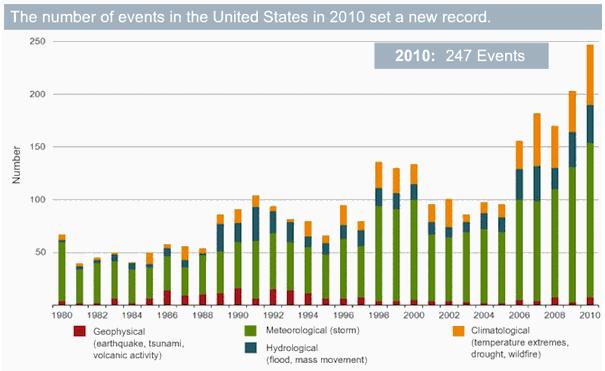
U.N. Extreme Weather Report Triggers Storm Of Protest. Here's an excerpt from
Der Spiegel: "
The report says that one "very likely" trend is that heat waves will occur more frequently and last longer around the world and that an increase in the frequency and magnitude of warm days and nights around the globe is "virtually certain." By the end of the century, the report predicts, temperatures on days with extreme heat will be between 2 and 5 degrees Celsius (3.5 and 9 degrees Fahrenheit) higher than they are today. The report is more cautious in what is says about heavy rainfalls. "There is medium confidence," it says, "that, in some regions, increases in heavy precipitation will occur despite projected decreases of total precipitation in those regions."


No comments:
Post a Comment