47 mph wind gust reported at Clara City (Chippewa county) Saturday morning, shortly after 9 am.
.08" rain fell yesterday at MSP.
1.35" precipitation since September 1. That's 5.72" less than average for the period.
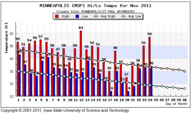
+5 F. November temperatures are running 5 degrees warmer than average in the metro area.
1,132 heating degree days since September 1. Translation: we've spent rougly 12% less heating our homes and businesses in the Twin Cities since September 1. Source: National Weather Service.

100: average number of days every year with 1" or more of snow on the ground in the Twin Cities.
160: average number of days every year with 1" or more of snow on the ground at Grand Marais and Lutsen, on Lake Superior's North Shore. Source: MN State Climate Office.
November 26, 1896: famous Thanksgiving Day Storm; rain and T-storms in southern Minnesota, snow and blizzard conditions in North Dakota and central/northern Minnesota counties. People caught traveling for the holiday. Severe cold wave as Pokegama Dam sinks to -45 F.
November 27-28, 1905: blizzard strikes Duluth with 60 mph winds. Ships sink in Lake Superior.
November 28, 1960: severe storm and blizzard, dubbed a "no'eastern hammered the Lake Superior shoreline, producing 20-40 foot waves which destroyed shoreline property. Three fee of water floods the streets of Grand Maraie, Minnesota. Winds gust to 73 mph and Duluth records over 1 foot of snow. Thousands of chords of pulpwood washed into Lake Superior. Source: MN State Climatology Office.
$2 billion: estimated cost of flooding on the Missouri River in 2011. Source: NOAA (story below).
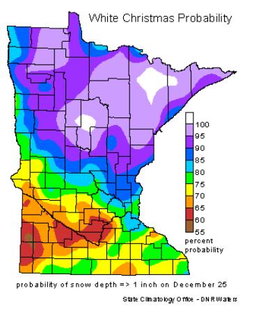
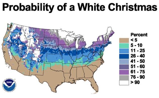
Historical Chances Of A White Christmas. I wouldn't worry too much about Santa and a lack of snow on the ground just yet. The odds are strongly in our favor that we'll have at least 1" or more of snow on the ground by December 24. More details from the Minnesota State Climate Office "Will we have a white Christmas? It's an age-old question that occurs to almost everyone this time of year. The chances of having a white Christmas vary even here in Minnesota. Having a white Christmas is loosely defined as having 1 inch of snow on the ground on Christmas Day. The snow depth at most sites is measured once a day, usually in the morning. The best chances of having a white Christmas is almost guaranteed in the Boundary Waters Canoe Area and a good part of the Arrowhead. The chances decrease to the south and west and the best chance for a "brown" Christmas is in far southwest Minnesota where chances are a little better than 60%. Northern Minnesota is one of the few non-alpine climates in the US where a white Christmas is almost a sure bet (U.S. White Christmas Probabilities)."
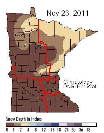
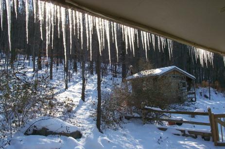
Where's The Snow? As of last Wednesday most of Minnesota was still snow-free, only 1-2" from near Hinckley to Duluth and International Falls. Click here for the latest from the Minnesota DNR.
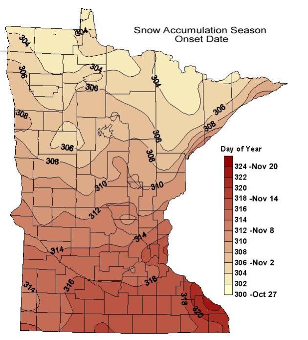
Average Start of Minnesota's "Snow Season". This map, courtesy of the Minnesota State Climatology Office, shows the start of the snow season around November 12 in the Twin Cities, based on data from 1971-1996. The first "blowing snow event capable of drifts" usually arrives on October 27 across the Minnesota Arrowhead, but as late as November 20 close to Winona. More details: "Average start date for the first blowing snow event causing drifts that remain persistent throught the winter. The product was generated using methodology of Tabler and based on the 1971 - 1996 mean monthly temperature records."

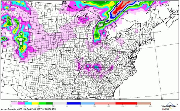
Snow Accumulation Through Midday Thursday. The GFS model is predicting a coating of slush as far south as the hills of northern Alabama and Georgia, some 2-5" lake effect snowfall amounts over Lower Michigan, more accumulating snow predicted west of Denver. An inch of snow may pile up on the Minnesota Arrowhead, closer to the Boundary Waters. Otherwise, a fairly quiet pattern for most of the USA. Map courtesy of WeatherCaster.
CHICAGO...
...122 YEARS OF RECORDS FOR FIRST DATE OF MEASURABLE SNOWFALL.*
...THE AVERAGE DATE OF FIRST MEASURABLE SNOWFALL IS 11/16.
...75 PERCENT OF THE YEARS HAD RECEIVED MEASURABLE SNOWFALL BY 11/25.
...84 PERCENT OF THE YEARS HAD RECEIVED MEASURABLE SNOWFALL BY 12/1.
...EARLIEST DATE OF FIRST MEASURABLE SNOWFALL:10/12/2006.
...LATEST DATE OF FIRST MEASURABLE SNOWFALL:12/16/1965.
LOOKING BACK AT THE 2010-2011 SNOW SEASON...NO MEASURABLE SNOW WAS
RECORDED AT BOTH CHICAGO-O'HARE AND ROCKFORD AIRPORT UNTIL DECEMBER
1ST. IN THE CURRENT FORECAST PERIOD...WET SNOW MAY MIX IN WITH
RAIN SHOWERS LATE SATURDAY NIGHT INTO SUNDAY...BUT NO MEASURABLE
SNOW IS EXPECTED. AFTER THAT...THERE IS A DISTINCT POSSIBILITY
THAT THE FIRST MEASURABLE SNOWFALL OF THE SEASON MAY NOT OCCUR AT
CHICAGO AND ROCKFORD UNTIL AFTER DECEMBER 1ST
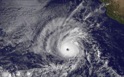
Hurricane Season A Sleeper In Southeast. Savannahnow.com has the story: "Hurricanes are like real estate. The three things that matter most about them are location, location, and location. So as the 2011 hurricane season comes to an end Nov. 30, it looks like a non-event from Savannah’s perspective. The only tangible effects here were high surf and some beach erosion from Hurricane Irene in late August. Otherwise, there was barely a leaf blown out of place. But it was an above-average season with massive damage elsewhere, especially in the Northeast, which is often spared the effects of tropical weather. Overall, the season racked up 18 named storms, the last of which was November’s Tropical Storm Sean. Seven of the storms were hurricanes and three of those were major hurricanes." Image above courtesy of NASA.
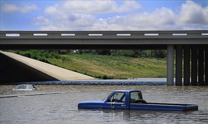
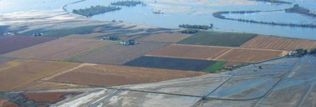
Missouri River Flood Drama Likely Took Direction From La Nina. Did a strong La Nina cooling of Pacific Ocean water last spring contribute to record flooding on the Missouri River? NOAA's Climate Watch has the story: "The Missouri is the continent's longest river. It trickles out of the mountains in Montana and flows east and south toward the Mississippi. Its waters are essential to the basin's farmers and ranchers, who raise 46% of the wheat, 22% of the corn, and 34% of the cattle in the United States. The river is also home to a system of dams, levees and spillways meant to insulate people living in the basin from the river's extremes. But in 2011 they couldn't keep the Missouri completely under control. Beginning in late spring and continuing through the summer, floodwater spilled over the Missouri's banks onto fields and towns, reaching up to five miles from the river's normal edge. The waters finall started to recede this fall, giving the basin's residents their first glimpse of the $2 billion in damages from this slow-moving catastrophe."


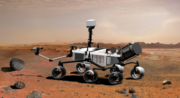
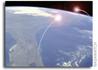
NASA Curiosity Rover On Its Way To Mars. Here's the story from Engadget.com: "It's been described by the scientist in charge as "the most complex mission that has ever been undertaken to the surface of another planet," and NASA's Mars Science Laboratory spacecraft is now well on its way to Mars. An Atlas V rocket carrying the Curiosity rover launched from Cape Canaveral this morning, and a successful separation of the craft occurred in space shortly thereafter, kicking off a journey to Mars that's expected to end with a rocket-powered descent to the planet in August of next year. (Image above courtesy of NASA).
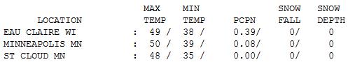
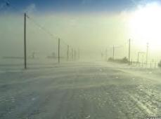
Blustery Saturday. The snow never quite materialized close to home, temperatures aloft warm enough for rain showers and sprinkles (the ECMWF European model was right killing off the snow chances). Temperatures fell during the day, whipped along by gusty winds in the 20-45 mph range. As much as .39" rain fell at Eau Claire, Wisconsin.

Paul's Conservation Minnesota Outlook for the Twin Cities and all of Minnesota:
TODAY: Cloudy start, slow PM clearing. Winds: NW 10-20. High: 36
SUNDAY NIGHT: Clear to partly cloudy. Low: 24
MONDAY: Plenty of sun, quite pleasant. High: 43
TUESDAY: Sunshine, seasonably cool. Low: 22. High: 33
WEDNESDAY: Sunny start, clouds increase. Low: 21. High: 39
THURSDAY: Another (dry) frontal passage. Low: 22. High: 32
FRIDAY: Sunny, windy and milder. Low: 17. High: 35
SATURDAY: Still sunny much of the day, still quiet for early December. Low: 20. High: 38

A Dry Groove
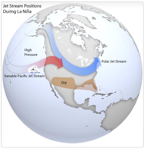
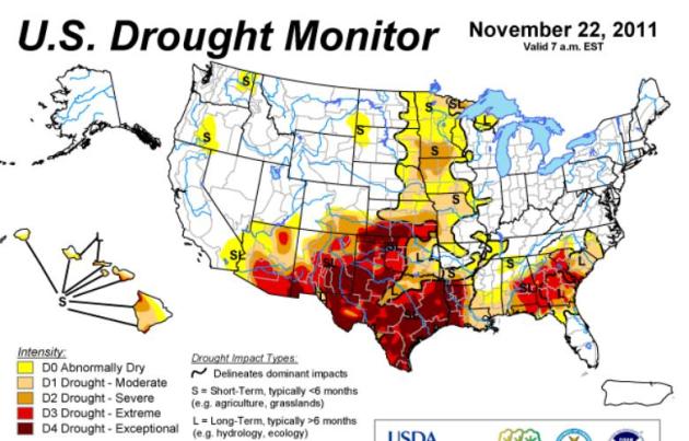
"When in a drought, don't predict rain - or snow." That old adage rings true. This IS a drought; 99% of Minnesota abnormally dry, more than 41% of the Gopher State in a moderate or severe drought. For much of southern Minnesota it's turning into the driest autumn on record, going back 141 years. We're talking a 7-9 inch rainfall deficit. I was hoping we'd have a few soaking rain storms before the ground freezes up solid, but right now I just don't see it. A La Nina cooling of Pacific water implies a colder winter, with a tendency for storms to sail south and east of Minnesota.
I've seen this countless times: the weather is more likely to get stuck in a specific rut, a groove, when Pacific water is unusually warm (or cold). The writing's on the wall: a bias toward drier weather which may linger into much of December. Like snow? I wouldn't panic just yet, but getting big storms into the metro may be the meteorological equivalent of swimming upstream the next few weeks.
Then again the probability of a white Christmas (1" or more of snow) at MSP is a whopping 70%. No storms imminent; a cold week is on tap, but no moisture. Get out and water shrubs and trees one more time in '11.
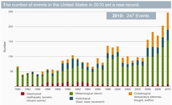
What's New (And What Isn't) In IPCC's Report On Extreme Weather? Inside Climate News has the story: "Severe weather in the United States and elsewhere has grown more frequent since 1980. Contributing to the shift is the accumulation of heat-trapping carbon dioxide in the air from human activities—though teasing out the exact contribution is tricky..... Droughts are more frequent and longer, particularly in southern Europe and West Africa, it found. As well, the frequency of days with heavy precipitation is up in some regions (warmer air holds more moisture). Tropical cyclones, the generic term for typhoons and hurricanes, have shifted poleward in recent years; and, as a result, storms have made landfall in areas that previously didn't lie in the tracks of cyclones. The IPCC said it is "likely"—a 66 percent to 100 percent probability—that the temperature and precipitation trends mentioned above are caused by a rise in greenhouse gas emissions from human activities like burning fossil fuels and deforestation. They are less certain about cyclones because of spotty historical records." Photo courtesy of NOAA.
Drought Puts Damper on Tree Farmer's Christmas. AP has the story. Here's an excerpt: "NEW CANEY, Texas (AP) — Dry, brown grass crunches underfoot as David Barfield walks through his 45-acre Christmas tree farm pointing at evergreens covered with brittle, rust-colored needles. "Dead tree, dead tree, dead tree," he says, shaking his head at dry timber he hoped would be chopped down by parents with excited children. Instead, Mother Nature delivered the Grinch in the form of a historic drought that has killed thousands of trees across Texas and Oklahoma. Some died of thirst. Others were destroyed by wildfires, whose breadth and intensity were magnified when wind swept the flames across parched landscape."
No comments:
Post a Comment