62 F. today's predicted high.
65 F. today's record high temperature in the Twin Cities (2001). We may come close.
Paul's Conservation Minnesota Outlook for the Twin Cities and all of Minnesota:
TODAY: Indian Summer! Plenty of sun. Winds: S 10-15. High: 62
SATURDAY NIGHT: Clouds increase. Low: 40
SUNDAY: Cloudier and cooler, a few rain showers likely. High: 47
MONDAY: Increasing clouds, light mix possible north PM hours. Low: 32. High: 44
TUESDAY: Partly sunny, chilly. Low: 28. High: 38
WEDNESDAY: Yep. Feels like November. Sunny and dry. Low: 22. High: 39
THURSDAY: Intervals of sun, still brisk. Low: 27. High: 45
FRIDAY: Light rain or drizzle possible. Low: 35. High: 42

Sunny Saturday, Sunday Frontal Passage. Infrared satellite images (measuring temperatures of clouds) show Sunday's cold frontal passage. Tomorrow may be 15-25 degrees cooler than today, a few passing showers or sprinkles possible, but no significant rain (or snow) is in sight. Satellite image courtesy of the Naval Research Lab.
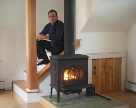
More Homes Heat With Wood, Raising Pollution Risks. USA Today has the story: "Mostly to save money, Matthew Walton switched a few years ago from heating his home with natural gas to wood, becoming a modern-day Paul Bunyan....."It saves us a bundle," he says, adding his wood stove can manage all winter with just two cords because he added insulation and good windows to his tidy, 1,300-square-foot home. As energy prices rise, and winter approaches, more Americans are turning to wood to heat their homes, some hurrying to cash in on tax credits for efficient stoves that expire next month. This upswing is prompting federal officials, concerned about the health and environmental impact of burning wood, to update 23-year-old certification criteria for stoves and set the first requirements for outdoor wood boilers, which heat water that's piped into homes."
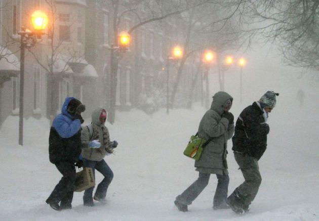
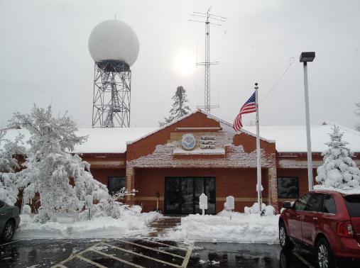
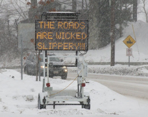
Winter Hazard Awareness Week in Minnesota. Here is a good overview of the various watches and warnings which will inevitably be issued in the weeks and months to come, courtesy of the MPX office of the National Weather Service:
Winter Weather Overview
The National Weather Service issues various products for hazardous winter weather events, to provide the public ample information and time to prepare for potentially life threatening conditions experienced with winter storms.Hazardous Weather Outlooks: Provide general information on developing winter weather up to a week before it occurs. While specific information, such as snow accumulations, may not be known until a day or two before a winter storm, you should closely monitor future forecasts and statements, and be alert for watches,warnings and advisories when winter weather is highlighted in an outlook.
Winter Storm Watch: Severe weather conditions, including heavy snow, blowing snow, freezing rain and/or sleet , may soon affect your area. if a watch is issued for your area, you should pay special attention to future forecasts and statements, and begin to make safety preparations.
Winter Storm Warning: Severe winter weather conditions are occurring or are imminent. Most warnings are issued for heavy snow and wind, but may also be issued for ice and sleet storms. If a warning is issued for your area you should take immediate action to ensure the appropriate safety precautions have been taken.
Blizzard Warning: Visibilities are reduced to less than 1/4 mile for several hours due to falling and/or blowing snow, making travel virtually impossible. The wind will be at least 35 mph.
Wind Chill: The cooling effect upon exposed skin, produced by the combination of temperature and wind. Note that the wind chill is based on a formula revised in 2001. A copy of the new Wind Chill Chart is available on our web site.
Advisories: These are issued for conditions which warrant increased public awareness and moderately hamper travel, but where the weather is not severe enough to merit a warning.
More specific information regarding watches and warnings can be found on our Watch, Warning, and Advisory definition list.
Midwest's Perfect Storm. Friday marked the anniversary of an historic storm and cold wave that shut down the state of Missouri. Freshare.net (based in Missouri's Ozarks) has the compelling story:
"Saturday, Nov. 11, 1911 saw what was probably the most sudden and dangerous cold blast in American history. People who enjoyed a summer like morning froze to death in heavy snowfall that evening. Blue skies changed to low clouds, driving rain, sleet, hail, thunderstorms, tornadoes and blizzards in half a day. Winds were so violent that they turned buildings into trapezoids. To better understand what created the storm and chronicle its impact, University of Missouri atmospheric scientist Patrick Market and a team of students have analyzed the storm with both modern meteorological tools and dives into the historical records. They’ve created a three-dimensional 21st Century model of what happened in the atmosphere to trigger the blast and an online map of the destruction that it brought to Missouri. Market, an associate professor in Soil, Environmental and Atmospheric Sciences in the School of Natural Resources, has for more than a year studied what climatologists call the Great Blue Norther of 11/11/11."
The Great "Blue Norther" of November 11, 1911. The Springfield, Missouri office of the NWS has another perspective, an article about the "Perfect Midwestern Storm": This article was originally published in the Ozarks Weather Observer for the October 2003 newsletter. It was written and researched by NWS SGF Meteorologist Drew Albert.
The term "blue norther" is most commonly associated with Texas. Various other names for the same phenomenon exist over the central and southern Plains. There are also various theories as to the exact origin of the term. In general it is associated with a rapidly moving cold front (usually in the Autumn) that causes temperatures to drop quickly and that often brings with it precipitation and unsettled weather, followed by a period of blue skies and cold temperatures. On November 11, 1911, the central U.S. experienced one of the most dramatic cold waves to affect the United States. During the early morning hours a deep Midwestern storm system, along with an associated arctic cold front, separated unseasonably warm and humid air from arctic cold. Temperatures ranged from the upper 60s and lower 70s over Missouri to the single digits in central Nebraska. As the day wore on, record warmth was felt across much of Missouri and Oklahoma. In Kansas City, the temperature rose to a record high of 76 degrees by late morning before the arctic front moved in from the northwest. Skies became overcast, winds shifted to the northwest, and the mercury began to plummet. By early afternoon, it was cold enough to snow, and by midnight the temperature had dipped to a record cold reading of 11 degrees above zero..."
3.2" Wausau, WI (old record: 3" in 1896)
8.9" Rhinelander, WI (old record was 2.6" in 1926).
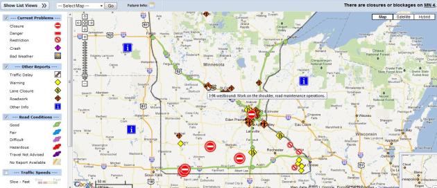
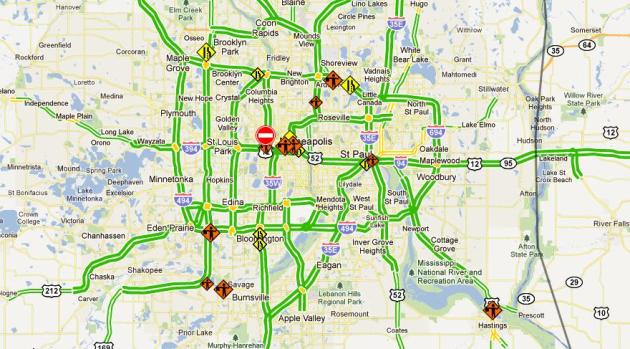
Wisconsin Dumping. A band of 6 to 9 inches fell from the Waupaca area to Florence, Wisconsin Wednesday into Thursday morning. The highest amount measured by an official NWS observer was 9.2 inches near Long Lake in Florence County.
Preparations
- Make sure your vehicle is ready for the season. Throughout the winter, keep your gas tank at least half-full to avoid gas line freeze
- Carry a winter storm survival kit. The typical kit should include a large coffee can with plastic lid. Inside the can, pack high energy foods, spare batteries for a flashlight, a red bandana or cloth to tie on the antenna, and candles/matches/metal cup to melt snow for drinking water.
- Other bulky or heavy items which should be in the vehicle include a shovel, jumper cables, a bag of sand or salt for traction, basic tools, blankets or sleeping bags, a tow cable or chain, a flashlight, a first aid kit, and extra clothing
- Consider keeping a cell phone. If you dial 911 from a cell phone, remember that the dispatcher may not know your location, so you must provide it to them. However, most new cell phones do have GPS capability.
- Before increasing your speed, get a feel for the traction. Remember that bridges and overpasses can be more slippery than other parts of the road. Do not brake suddenly. If you have anti-lock brakes, apply steady and firm pressure to the pedal. Do not pump anti-lock brakes
- If you begin to skid, remain calm. Ease your foot off of the gas and turn the wheel in the direction you want the front of the car to go
- When driving near snowplows, remember: Stay Back, Stay Alive. Reduce your speed. Never drive into a snow cloud. An average snowplow weighs 17 times more than an average car. If you are in a collision with a snowplow, you will lose. Be patient; follow eight seconds behind snowplows.
- Check the latest weather information as you drive
- If severe winter weather is expected, consider postponing travel
- Avoid traveling alone during a winter storm
- Always fill the gas tank before entering open country, even for a short distance
- Stock your vehicle with a winter storm safety kit
- If the storm begins to be too much for you to handle, seek refuge
- Stay in your vehicle. Do not attempt to walk in a winter storm. You can easily become lost and disoriented in blowing and drifting snow. Staying in your car decreases your risk of frostbite and increases the chance of being rescued. make your vehicle visible to rescuers
- Beware of carbon monoxide. Run the engine a few minutes every hour, or every half hour in extreme cold. Keep one window slightly open. Make sure that snow does not block the exhaust pipe
Elementary Media Center from 3:15-4:30 p.m. on Nov. 11 for a hot drink and a chance to tell their story and hear the stories of others."
"I was living in Belle Plaine, Minn. There was no warning of the impending blizzard. Duck hunters were in their glory to have such a nice day. Cows were still grazing the local pastures."
- Donna Heath
"We got some ducks that day and about 9 a.m. we noticed it getting colder very fast. A strong wind started to blow from the northwest and heavy clouds moved in. We weren't dressed for cold weather so we started home. By the time we started to walk the half-mile to our home a freezing rain froze to our clothes and guns."
- Harold Kick
"The family, all six of us, got into the car and headed for my uncle's. Almost as soon as we left home, the sun went under the clouds, the wind started blowing, and the snow came down. It started so suddenly it took us all by surprise, but my dad kept driving. It got worse and worse."
- Ella Mae (Russell) Caroon
"Two flat bed trucks with crates to hold 500 live turkeys were to pick up our turkeys on Nov. 11. Because of the storm, the trucks never came."
- Stanley Teeman
"I was staying with my grandparents ... when the temperature suddenly dropped, and the snow began to pile up, my parents decided they had better drive the four miles to pick me up. After my father picked me up and we were headed back [home], the car got stuck in a snowdrift about one and a half miles from my grandparents' home. My father ... started to walk back to Norwood, carrying me in his left arm."
- JoAnn Mueller Trampe
* You can read more remarkable stories from Armistice Day survivors in the Pine City Pioneer
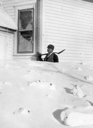
** Here's more on the Armistice Day Blizzard from Dr. Mark Seeley in his WeatherTalk blog: "November 11-12 of 1940 brought the famous Armistice Day Blizzard to Minnesota with heavy snow and winds of 40-60 mph. Collegeville reported 26.6 inches of snow from this storm, while 24 inches was reported at Meadowlands and 22 inches at Orr. All transportation services (streetcar, railroad, airlines, and bus operations) were shut down for a time. Power outages were widespread as a result of ice, and many hundreds of stranded motorists sought refuge in homes and schools. In all 49 people lost their lives in this storm."
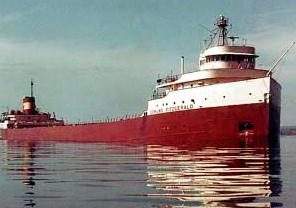
Originally the forecast for Nov. 9-10 was to be windier than normal, but after the Fitzgerald left port, heading from Superior, WI to Detroit, MI, the forecast was upgraded to a gale warning, then eventually a storm warning. Another ship, the Anderson, joined the Fitz on a similar route, heading to Gary, IN. After the ships parted ways, both captains changed course to head on a northerly track to avoid the storm. The Anderson lost contact with the Fitzgerald around 7:15 pm on November, 10th. It sank with all 29 men on board.
NOAA has a good overview of the meteorological events leading up to the disaster here.
Here is another paper, "Reexamination of the 9-10 November 1975 "Edmund Fitzgerald" Storm Using Today's Technology".
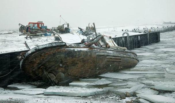
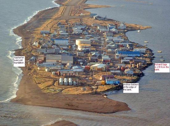
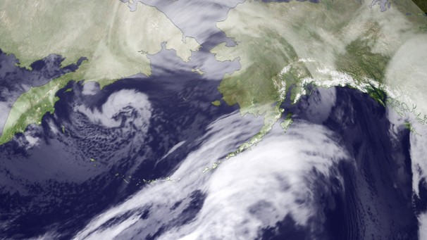
* Alaska "Snowicane". The Washington Post has more on the unusually severe storm that lashed Alaska. "A storm of historic intensity continues to pound the west coast of Alaska today. Twice the size of Texas, the storm is as deep as a category 3 hurricane. The National Weather Service is calling it a “life-threatening epic storm” due to its dangerous combination of towering waves (observed at 40 feet in the Bering Sea), winds over 100 mph, storm surge flooding, and blinding snow. The storm’s central pressure bottomed out at 943 mb this morning, comparable to the minimum pressure (942 mb) of hurricane Irene, which caused billions in damage along the East Coast in late August. From this point forward, the storm - essentially a snow hurricane (or snowicane) - is forecast to slowly weaken, but will continue battering the region into tonight."
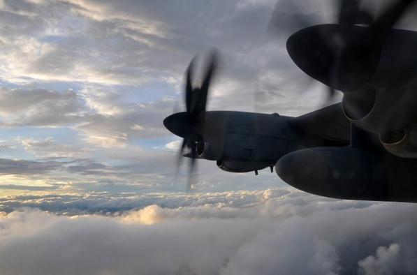
Hurricane Hunters Fly Into Tropical Storm Sean. America is the only nation on Earth that flies big, 4-engine turboprops into tropical storms and hurricanes. Why? Because you can only glean so much from satellite observations. Our Amazing Planet has the details: "Storm-chasing aircraft headed out over the Atlantic Ocean and into the swirling clouds of Tropical Storm Sean this week, taking measurements that allowed forecasters to confirm their suspicions about the season's 18th named storm. "It's textbook. A textbook storm," said Dennis Feltgen, spokesman for the National Hurricane Center in Miami, Fla. The weakening storm, packing winds of about 50 mph (80 kph), is heading northeast, away from the United States, and looks like it will weaken significantly in the coming days......"Every storm has its own personality," Cross said. "They're all different, so as crew members we can never let our guard down." Feltgen said that although the United States won't feel Sean's direct effects, the storm is creating powerful and dangerous rip currents along the southeastern U.S. coastline. The high winds push narrow channels of water rushing toward the shore, shoving the water in the shallows out of the way and sending it surging out to sea."
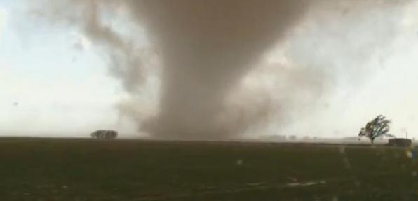
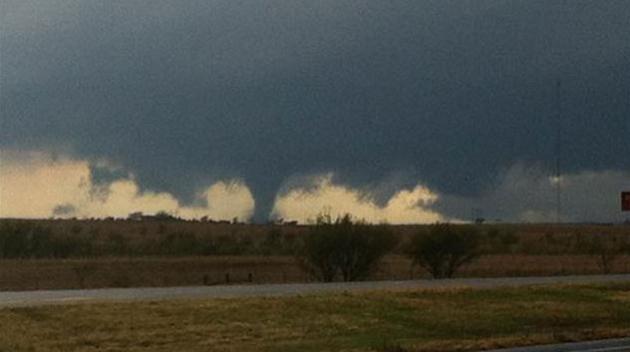
Photo credit above: "Storm chasers caught up with one tornado during the Oklahoma outbreak.
Credit: Tornadovideosdotnet/YouTube"
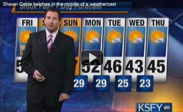
Forecast: Nothing To Belch At. I feel bad for this guy. One question: was the burp big enough to show up on Doppler? TVSpy has the sloppy details: "KSFY meteorologist Shawn Cable learned an important lesson this morning: don’t chug a bunch of Dr. Pepper before going on air. While delivering the forecast this morning, Cable let out a burp that halted his weather update (video above). “Alright, that one’s gonna make the reel,” Cable said, trying to regain his composure as his co-anchor Nancy Naeve Brown lost it off camera. “At least it didn’t come out the other end.”
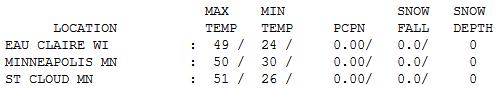
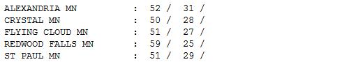
Above Average. Under a brilliant blue sky temperatures topped 50 across most of Minnesota, ranging from 50 in the Twin Cities to 51 at St. Cloud and 59 in Redwood Falls, a premonition of what's to come today.
Last 60 of 2011?
Consider the alternatives: nearly 5" snow on this date in 1988. In 1966 we woke up to 4 below on the 12th day of November. No matter what your opinion of winter, whether you welcome it with open arms, or curled up in the fetal position, one thing is certain: days like this will make the Winter of '11-12 seem shorter, more compressed.
The weather is stuck in a rut, a groove that favors big storms passing just south of Minnesota. I still don't see a "high amplitude" pattern (major dips and bulges in the jet stream steering winds) that would favor big storms or arctic invasions. Models are hinting at a few inches of slushy snow the Wednesday before Thanksgiving, but it's too early to speculate further; confidence level is low.
My advice: make the most of our fine Weather Honeymoon - highs today near 60, some 15 degrees above average. Sneak out into the yard this afternoon. Rake leaves in your shorts. You'll find it vaguely therapeutic.
Rain showers arrive Sunday, as chilly air pushes back into Minnesota. Heavy jacket weather returns next week (30s, low 40s) but no advisories, watches or warnings are imminent.
I have a nagging hunch I won't be bored too much longer.
2 Degrees Of Disaster. here's a thought-provoking article from The New Yorker: "Two years ago, at a meeting in Copenhagen, world leaders agreed on the goal of limiting global warming to two degrees Celsius, or roughly three and a half degrees Fahrenheit. The so-called Copenhagen Accord, which Barack Obama personally helped negotiate, contained no mechanism for meeting this goal, so even though the President called it a “meaningful and unprecedented breakthrough,” many others questioned whether it was worth the proverbial paper it was printed on. Unfortunately, it now seems, the many others had a point. On Wednesday, the Paris-based International Energy Agency released its annual “World Energy Outlook.” Among the report’s key findings is that, in spite of a shaky economy, global carbon-dioxide emissions rose by five per cent last year, to more than thirty billion metric tons. Meanwhile, energy efficiency—defined as the amount of energy used per unit of economic output—declined for the second year in a row. According to the I.E.A., “The door to 2°C is closing.” The group warned that unless dramatic action is taken by 2017, so many additional billions of tons of emissions will effectively be “locked in” that a temperature increase exceeding two degrees will become inevitable."
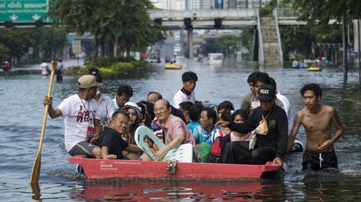
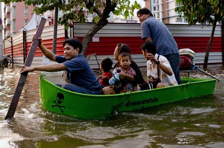
Climate Change To Bring More Floods. The story from The Mother Nature Network: "Climate change will bring more floods and extreme weather to Southeast Asia, a World Bank official said Thursday on a visit to the region, where hundreds have died in severe inundation. "What we are seeing is there are more floods, more extreme weather events, higher temperature, more variable rainfalls and we believe that is caused by climate change. And we should expect this to increase, sadly," Andrew Steer, the World Bank's special envoy for climate change, told reporters in the Vietnamese capital Hanoi. Thailand's worst floods in half a century have killed 533 people and damaged the homes and livelihoods of millions around the country."
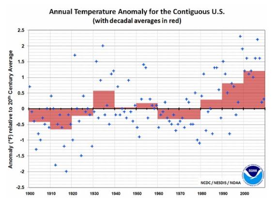
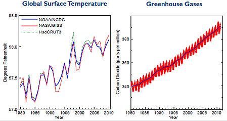
2000-2009: Warmest Decade On Record. It's important to remember that the USA makes up 1.6% of the world's surface, so we can't extrapolate what's happening over the lower 48 states and imply that the same trends are happening worldwide. From an article at Media Matters: "The following chart from NOAA shows that 2000-2009 was the warmest decade on record for the contiguous U.S."
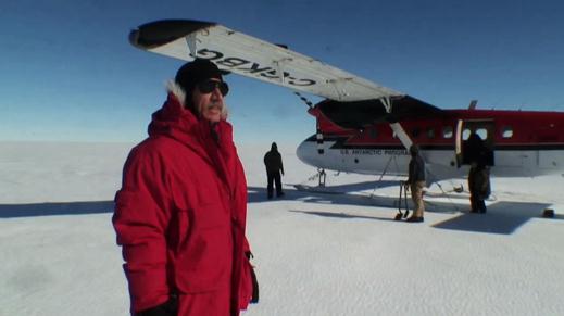
Researchers Ship Out To Antarctic "Hot Spot", While Chicago Looks To Worst Winter In USA. Here's a press release from the Medill School and Northwestern University: "New research in one of Antarctica’s “hot spots” will help scientists better understand the effects and extent of climate change on both the world's largest ice sheet and the rest of the planet. “One of the biggest uncertainties in global models of how the earth will respond to warming is the question of sea level rise,” said Scott Borg, director of the Division of Antarctic Sciences for the National Science Foundation and one of the scientists who will soon ship out to Antarctica’s Pine Island Glacier. “This project goes to the heart of the question.” But, when it comes to climate change, extreme weather conditions are also a concern. For this reason, the melting Antarctic glaciers and record cold winters in the Windy City actually have something in common, said Timothy Stanton, an oceanographer at the Naval Postgraduate School in Monterey, Calif. The changes in both places are symptomatic of global warming, according to predictions of climate models. “What they consistently show is that the actual oscillations of weather, the annual variability, are much higher as you increase the effects of global warming,” Stanton said."
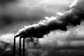
Greenhouse Gas Index Shows Sharp Increase. Details from the Miami Herald: "Greenhouse gases are building at a steep rate in the atmosphere, the nation's top climate agency reported, renewing concern that global warming may be accelerating. The National Oceanic and Atmospheric Administration's Annual Greenhouse Gas Index, which indexes the key gases known to trap heat in the Earth's atmosphere, rose 1.5 percent from 2009 to 2010, the agency reported. The reported rise came on top of an analysis by the Energy Department last week that said global emissions of carbon dioxide, a key, long-lived greenhouse gas, jumped in 2010 by the biggest increment on record. The figures showed a 6 percent increase from the year before, a steeper rise than worst-case scenarios that were laid out by climate experts four years earlier. The Annual Greenhouse Gas Index number, by contrast, looks small, but has big impact. The index is a measure of the combined heating effect of the top greenhouse gases during their life spans as the gases float around in the atmosphere. The number increased from 1.27 in 2009 to 1.29 in 2010. Since the index started in 1990, which the NOAA team chose as a baseline, the increase has been 29 percent." Photo credit: realclearenergy.org.
No comments:
Post a Comment