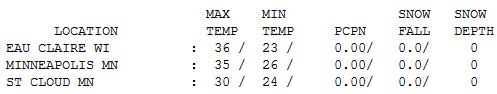
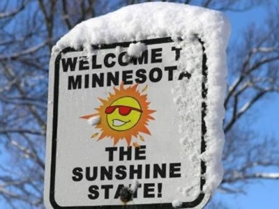
35 F. high Tuesday in the Twin Cities.
24 F. average high for December 27.
9 F. average low for December 27.
40 F. possible again today. If so it will be the 6th day at or above 40 in December. Last year: 1 day above 40 in December.
2,275 heating degree days as of December 27. So what? That means we're spending:
20% less than average so far this winter season heating our homes and businesses, and...
16% less than last winter on heating bills, to date.
17 of the last 27 days have seen daytime highs at or above 32 F. in the Twin Cities.
Coating snow possible late Thursday night/Friday morning.
Alberta clippers: models suggest a series of (weak) Alberta Clippers, weak, fast-moving (moisture-starved) storms diving out of southern Canada - through the first week of January. No major storms are in sight through the first week of January.
Warmest Christmas Day in 90 years across much of Britain, according to the BBC. Details below.
Louisville and Lexington have reached their wettest years on record, with Louisville seeing 67.72 ” and Lexington seeing 65.76″, breaking the old record set in 1936.
"
To love what you do and feel that it matters - how could anything be more fun?" - Katharine Graham, Washington Post.
Why Fly South? Here's a note I got from Peter Tharaldson, who works at Best Buy: "
Hi Paul- this might be an interesting photo. It is from Toqua Lake in Graceville, MN (far western MN in the hump). The geese never flew south. There are about 6000 sitting on this lake and they actually create enough stir to keep a section of water open...although the weather helped this last weekend."
* This came in on my Facebook page - thanks Peter, and keep the weather-related photos and stories coming! I'll kick the Doppler (again) and see if we can get some snow up here. I'm just as freaked out as everyone else...
"
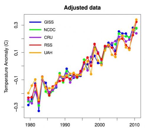
The U.N.'s World Meteorological Organization said global temperatures in 2011 are currently the 10th highest on record, higher than any previous year with a La Nina event, which has a relative cooling influence". - from a Reuters article about extreme weather in 2011 and a look ahead to 2012.
"
The NASA Goddard Institute for Space Studies had already predicted that extreme droughts would be an every-other-year phenomenon in the United States by the middle of this century....And of course, the American Southwest is not the only region experiencing drought apparently tied to climate change. According to the journal Science, of the 12 driest winters the Mediterranean has experienced since 1902, 10 have occurred in the last 20 years. Researchers from the National Oceanic and Atmospheric Administration say climate change can explain half of the added dryness." - from a New York Times book review highlighted below.
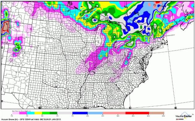
A Snow-Free Week Across Much Of The USA. The latest GFS model prints out a couple inches of snow for far northern Minnesota, plowable amounts of snow for northern Wisconsin, much of Michigan, and some of the snow belts downwind of the Great Lakes, with as much as 8" for upstate New York. Otherwise you'll have to look long and hard to find any significant snow through New Year's Day. Map courtesy of NOAA and WeatherCaster.
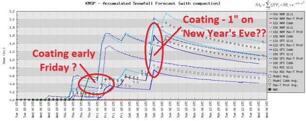
Couple of "Nuisance" Snow Events. Not very exciting - I miss the BREAKING NEWS leading the local newscasts. It's like being a weatherguy in Nashville, or maybe Shreveport, Louisiana. Adding insult to injury parts of Arizona, New Mexico and west Texas has seen considerably more snow than Minnesota has so far this winter. What's up with that? Models hint at a little slushy snow late Thursday night - another chance of rain ending as a coating to 1" of slush New Year's Eve. My confidence level for Saturday's possible snow is very low - stay tuned for updates.
Here's What Snow Looks Like. True, you'd have to drive to Morgantown, Indiana to see this. Thanks to Melissa Lloyd at bamchase.net for sending this in to WeatherNation.
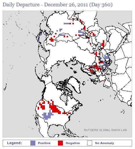
A Snowfall Deficit Across Much Of North America. This is a graphic from Rutger's
Global Snow Lab. The red-shaded areas are regions that should have significant snow on the ground - but don't. Not only much of the USA, but northern Europe and parts of Asia.
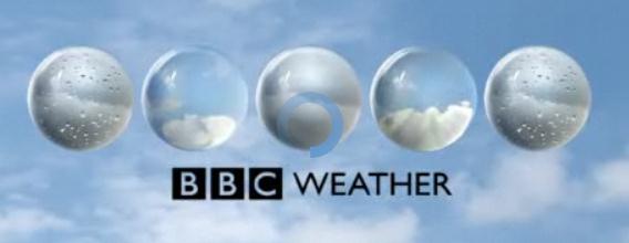 Mildest Christmas Day In 90 Years For U.K.
 Apparently North America wasn't the only region experiencing an unusually mild Christmas. The
BBC reports: "
What a difference a year makes! While Christmas Day in 2010 saw most of the United Kingdom blanketed in snow, Christmas Day 2011 has been unseasonably mild. In fact, Murlough in County Tyrone in Northern Ireland saw record-breaking warmth, whereas Dyce in Aberdeenshire in Scotland was the place to be for the highest temperature in the whole of the UK."
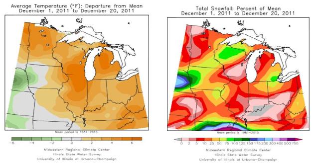
"Winter Lite". The Chicago office of the National Weather Service shows departure from normal for temperatures (above left) and snowfall (above right). December temperatures are running 3-8 degrees above average this month, snowfall anywhere from 5-50% of normal for most of the Upper Midwest since December 1.
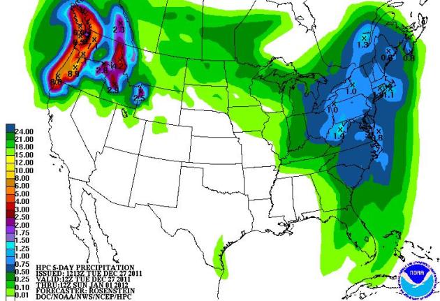
Soaking Rains For The Pacific Northwest. NOAA's 5 day "QPF" (quantitative precipitation forecast) calls for in excess of 8" of rain for coastal Oregon and Washington State, which may result in flash flooding, even a few mudslides. The pattern favors rain and snow for the Northeast, but fairly quiet, dry weather over the southern half of the USA.
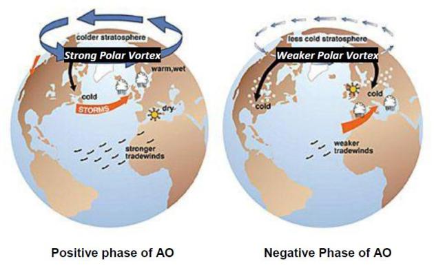
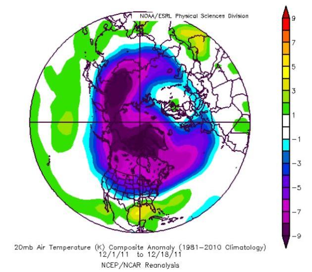
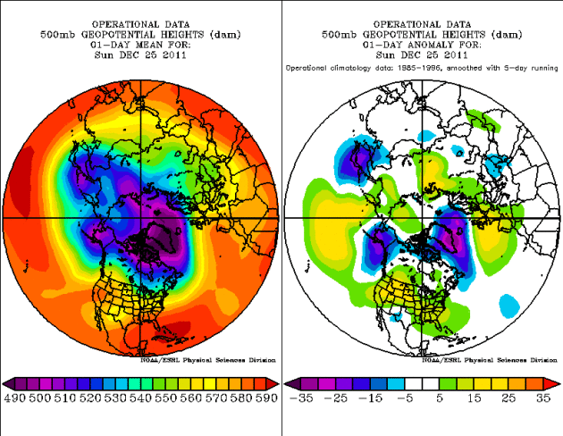
When Will (A Real) Winter Arrive? We are currently in a very strong (positive) phase of the Arctic Oscillation (AO), which correlates with powerful westerly winds trapping the coldest air over Alaska and northern Canada. Last year, in stark contrast, there was a very strong negative phase of the AO, which allowed bitter air to plunge south. Here's a great overview of the state of our winter, along with explanations of blocking patterns (AO and NAO) and why a radical shift to bitter air is unlikely through at least the middle of January, courtesy of the Chicago office of the
National Weather Service: "
Some of the global forecast models utilized by weather forecasters do predict stratospheric temperatures out to 240 hours to as much as 384 hours in advance, but thus far there has been no strong evidence of a major breakdown of the unusually cold stratospheric temperatures that have been locked over the polar region. Considering the linkage of this feature to the phase of the AO/NAO that has been discussed here, it is very likely that the polar vortex will remain anomalously strong at least through the beginning of January, keeping the truly cold air locked over far northern Canada and Alaska. Therefore, the AO and NAO can both be expected to remain in their positive phases for the foreseeable future.
In conclusion, until we are able to transition to a prolonged negative AO/NAO, we can expect to have near to above average temperatures and above average precipitation. It appears this will be the case for most of this winter season, as a prolonged positive AO/NAO looks to continue into January. Although uncertainty increases with the behavior of the AO/NAO later this winter season, the latest trends indicate the winter season as a whole will be marked by the positive phase. Therefore, in spite of the fact that La Nina conditions are in place again this winter, it does not appear that winter season will replicate last year’s cold and snowy winter. Instead odds favor this winter to continue to be on the warm and wetter side of average."
* image above courtesy of the National Snow And Ice Data Center.
No Evidence Of Stratospheric Warming - Yet. Meteorologists have uncovered a link between temperature trends in the upper reaches of the atmosphere, the stratosphere, and the tendency for bitter, arctic air to develop over northern Canada, Alaska and Siberia. When the stratosphere warms (dramatically) temperatures at the surface tend to take a nose-dive. There's a lag of a couple of weeks, but it's uncanny how well this works out. For the last few months stratospheric temperatures have been MUCH colder than normal, with no signs of imminent warming (which would lead to arctic air pushing southward into the USA). Here's a
summary (pdf) from the Chicago office of the NWS: "
We can see that temperatures have not been just slightly below the 1981-2010 normal in the stratosphere above the polar region, they have been substantially below normal. These anomalies fit in well with the diagram in Figure 9, so that the anomalously strong polar vortex noted in Figure 10 make sense. This is important because it will take significant stratospheric warming to result in a weakening of the vortex and an atmospheric pattern more favorable for a negative AO/NAO."
Will 2012 Top 2011 For Record Weather Disasters? Reuters has the story: "
Global reinsurer Munich Re says natural catastrophe losses for the first nine months of 2011 totalled $310 billion, a record, with 80 percent of all economic losses occurring in the Asia-Pacific region. Since 1980, weather-related disasters globally have more than tripled. The United States set a record with 12 separate billion-dollar weather disasters in 2011, with an aggregate damage total of approximately $52 billion, the National Oceanic and Atmospheric Administration said this month. The U.N.'s World Meteorological Organization said global temperatures in 2011 are currently the 10th highest on record, higher than any previous year with a La Nina event, which has a relative cooling influence.
Goodbye, Good Riddance 2011.
The Shreveport Times has an Op-Ed from Jack Hayes, Director of the National Weather Service: "
During these last 12 tumultuous months we've experienced more than 1,000 weather-related fatalities, more than 8,000 injuries and at least 12 — a record for a single year — separate disasters with economic losses greater than $1 billion. Numbers like these have served as a wakeup call, a jolting realization that our society is increasingly vulnerable to the weather as a result of a growing population and sophisticated infrastructure that continues to expand.And while we witnessed an unmatched succession of extremes in nearly every weather category this year, climate scientists have pointed to the likelihood that such extremes are not an anomaly but may be the new normal."
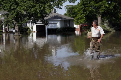
States May Lose Crucial Flood-Predicting Tools. The story from
nola.com: "
WASHINGTON More than three months after the heavy rains of Tropical Storm Lee pummeled much of the East Coast, the city of Binghamton, N.Y., is still rebuilding. During the height of the storm, the waters of the Susquehanna River surged over floodwalls and into the streets, forcing 20,000 people in the area to flee their homes. Cleanup efforts will continue into the spring. The city will get a slice of the $50 million disaster aid package Gov. Andrew Cuomo signed earlier in December, but that money won't prevent floodwaters from staging another assault on Binghamton and other cities lying in the Susquehanna River Basin _ one of the nation's most flood-prone areas. Flooding is always a worry along the wide, shallow Susquehanna, which spills its banks yearly and has been doing so with growing intensity in recent years. To people living in the basin, timely weather warnings are essential. But those who have the job of issuing those warnings are worried about what might happen next flood season, when they will likely have fewer tools to do the work." Photo above courtesy of AP.
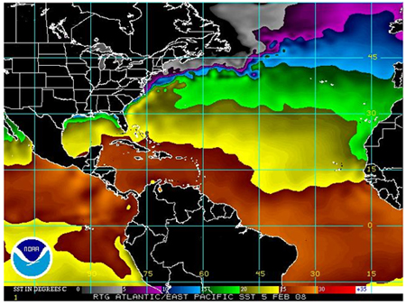
Atlantic Warm Pool Influences On U.S. Land-Falling Hurricanes. CO2 Science has an overview of some potentially breakthrough research:
"Working with data for the period 1970-2009, the two researchers found that a large Atlantic Warm Pool (AWP, a large body of warm water that includes the Gulf of Mexico, the Caribbean Sea and the western tropical North Atlantic) tends to produce a greater number of TCs, while at the same time it shifts the TC genesis region eastward, so that "it increases the chance for a TC to move northward without making landfall in the United States." And they add that "a large AWP also induces barotropic stationary wave patterns that weaken the North Atlantic subtropical high and produce the eastward steering flow anomalies along the eastern seaboard of the United States."
NOAA Research Covered The Globe In 2011. Physorg.com has a
good summary of NOAA research this year: "
NOAA scientists plumbed the deep ocean, probed the heights of the stratosphere, and surveyed some of the fiercest storm systems on Earth in meeting 2011's scientific challenges. Their discoveries are paying off in longer storm warning lead times, better understanding of our climate, and new knowledge about environmental disasters. NOAA's Office of Oceanic and Atmospheric Research (OAR) conducts the scientific research that advances weather forecasting, climate prediction, and environmental modeling, as well as our understanding of coastal threats such as tsunamis and oil spills. While every year brings its unique challenges, 2011 set a new record for the most billion dollar weather and climate disasters in a single year – 12. "Our research improves the ability to forecast where a hurricane will make landfall and lengthens tornado warning lead times," said Craig McLean, acting assistant administrator for NOAA OAR. "As challenging a year 2011 has been, our scientists have matched it with outstanding environmental research accomplishments."
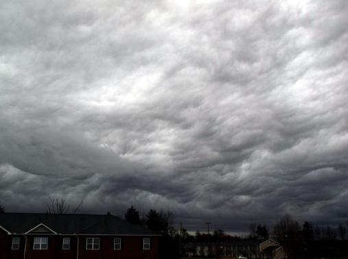
A Wild Sky. Thanks to one of our prolific weather spotters, Dennis Mersereau, in North Carolina for passing this on: "
these are the strangest clouds I've ever seen. They just passed through in Reidsville, North Carolina, on the tail end of a line of heavy rain. This was taken looking southeast in the general direction of Burlington and Greensboro, NC."
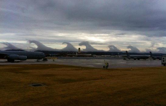
Strange "Tsunami Wave Clouds" Explained.
Dvice.com has a good explanation of what created these dramatic clouds near Birmingham, Alabama a few weeks ago: "
Residents of Birmingham, Alabama woke last Friday to skies that looked more like an ocean, with a series of huge "wave" shaped crests rolling slowly across the sky. Experts have now explained the phenomenon as perfect examples of "Kelvin-Helmholtz" waves, when a fast layer moves over a slower layer and drags the top along creating a curled shape. You'll recognize Kelvin-Helmholtz waves when put in context of the ocean. This kind of turbulence forms when the top layer — air — moves faster than the water layer below. This creates what we all know as wave crests or breaks when the water surges forward. The phenomenon is less common in the sky, but when it does occur the principle is the same."
Flight On Time? It's another big week for travel, by car and plane. Here's a bookmark-worthy site,
flightstats.com, which has real-time updates from major airports around the USA. As you can see Tuesday was a rough day for air travel from Atlanta to New York.
Incredible Things That Happen Every 60 Seconds On The Internet. I thought this was an interesting infographic, courtesy of
Business Insider: "
In a single minute there are over 695,000 status updates on Facebook. That's just one example of the mind boggling scale of online activity. The following infographics show a bunch of other incredible things that happen in 60 seconds (via Barry Ritholtz)." More factoids from
the article below:
- 13,000 hours of Pandora music is listened to
- 20,000 new posts are posted on Tumblr
- 25 hours-worth of videos are uploaded to YouTube
- 370,000+ minutes of voice calls are made on Skype
8 Ways To Go Viral. If your company makes a product or service you (like me) may be wondering what steps you can take to increase the odds of "going viral". Techcrunch.com has a
great article with some helpful suggestions: "
Many entrepreneurs struggle with the question: “How can I make my product more viral?” After looking at many successful web startups, I boiled down virality to eight different tactics, or types, that are the most common. Grab a pen:
1. Inherent virality
The type of virality you’ll die for. Simply put, a person gets no value from the
product unless other people use it as well. As a result, she shares the product with other people. Sharing is done via sharing mechanisms (e.g: invite your Gmail contacts) or through pure word of mouth.
Seeding, which means getting the first people on board is very hard because of Metcalf’s Law (there’s very low value for the first users of the product). However, the growth after the seeding period, usually through word of mouth, can be explosive. This is how Skype came to be what it is."
Can Apple Become The Next Big Content Creator? Will Apple launch iTV in 2012?
Mashable.com examines the possibilities: "
The status quo for visual content has always been that its creation, delivery and consumption have clearly delineated borders. Content creators make it, cable providers deliver it, and viewers consume it on the big screen in their living room. In the last few years, however, we’ve seen a fundamental shift in the visual content landscape. For the first time since the advent of cable television in 1948, the lines are blurring as the quality of content created by non-prime networks — and even individuals — continues to improve. Plus, content increasingly reaches us over the Internet, consumed on whatever screen we happen to be in front of. As rumors about an Apple television continue to gather steam, many believe that a content package of some kind will be part of any new iTV offering."

. O.K. I'm a little biased, because Tricia Frostad is a friend (her husband, Todd, is my good friend and business partner). Their garden in Chanhassen is absolutely incredible - like something out of a storybook. Apparently Bill Ward at the
Star Tribune agrees: "
It was a short move -- from one side of Chanhassen's Lotus Lake to the other -- but for Tricia Frostad, the new place meant "initiation by fire." Leaving a log cabin with no yard to speak of in October 2002, she and husband Todd settled into a 1-acre property with a smallish front yard and a woodsy back lot that careened precipitously down to the lake. Beyond helping her mom plant tulips and filling a few containers at the former home, she had no gardening experience. So how did a suburban mom evolve from someone who "would look at a catalog and think 'That's way too technical for me'" to a master gardener with a great eye for color and design? "I caught the bug," she said. And with it came some cramming that would make a college student blush. The textbooks: "Perennials for Minnesota and Wisconsin" and "Annuals for Minnesota and Wisconsin."
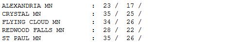
Cooling Off. Are we ever getting spoiled. Temperatures are (consistently) running 10-20 degrees above average - Monday's 52 degree high was close to 30 degrees above normal. Remarkable. We cooled off a bit yesterday, back down to (only) 5-10 degrees above average. Highs ranged from 23 at Alexandria to 30 St. Cloud, 35 in the Twin Cities and 36 at Eau Claire.
"
You've got a lot of choices. If getting out of bed in the morning is a chore and you're not smiling on a regular basis, try another choice." - Steven D. Woodhull (U.S. geologist).
Paul's Conservation Minnesota Outlook for the Twin Cities and all of Minnesota:
TODAY: Partly sunny, turning milder again. Winds: SW 8-13. High: near 40
WEDNESDAY NIGHT: Clouds increasae. Low: 29
THURSDAY: Gray. A little rain possible late, possibly ending as a coating of slushy snow late Thursday night. High: 38
FRIDAY: Flurries taper, slow PM clearing. Low: 23. High: 34
NEW YEAR'S EVE: Cloudy, mild, passing (rain) shower? Low: 30. High: 41
NEW YEAR'S DAY: Becoming sunnier, winds ease up. Low: 22. High: 32
MONDAY: Blue sky, mild start to 2012. Low: 19. High: 35
TUESDAY: Partly sunny, warming up again. Low: 23. High: 39
An Abbreviated Winter?
Love it or hate it, our lack of snow and bitter cold will probably make for a shorter than average winter for much of Minnesota. Every day that passes with no windchill advisories is a gift from on high.
On average the metro area enjoys 7 nights below zero in December. So far this year: no subzero nights; temperatures for the month 6.6 F. warmer than average. A lack of snow and cooling from below means daytime highs can climb 5-10 degrees higher than they would otherwise.
We're seeing a strong (positive) AO, or "arctic oscillation", which means unusually strong west winds blowing from the Pacific are keeping the coldest air of winter bottled up over far northern Canada. When the stratosphere warms dramatically surface temperatures over North America often plummet a few weeks later. So far we don't see any dramatic warming of the upper atmosphere (which could be a cue of a coming cold wave) - although I do see a chance of single digits and teens after January 12. We're due.
No big storms brewing; the atmosphere probably warm enough for RAIN late Thursday. Go figure. No major travel headaches in sight; Near 40 on New Year's - mostly 30s for highs the first week of 2012.
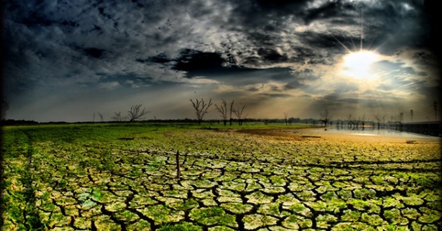
Portraits Of The Southwest In The Shadow Of Drought. The New York Times reviews 2 books on the struggle for water in the southwestern USA, one book focusing on the meteoric growth of Phoenix. The article has some very interesting facts: "
Though we think of the Southwest as dry — and it is dry — its development and population took off during a period in the 20th century when it enjoyed perhaps its wettest weather in hundreds of years. The killing droughts that have lately gripped the region were unusual by recent standards but otherwise all too typical and all too likely to recur — a prospect the National Research Council has called “sobering.” That prospect is the subject of two new books, “A Great Aridness,” by William deBuys, a conservationist based in New Mexico, and “Bird on Fire,” by Andrew Ross, a social scientist at New York University." Photo above courtesy of the Los Angeles Times.
Bullying The EU On Global Warming, Or Trying To. The story from
Huffington Post: "
It's been obvious for some time now that the Obama administration's promises to fight global warming are in mothballs. But it's still shocking to see Secretary of State Hillary Clinton attack the 27 European countries that are actually trying to do something about the greatest environmental challenge of our time. The European Parliament in 2008 enacted a broadly popular law aimed at reducing Europe's carbon pollution. As of January 1, 2012, it will begin to apply to the aviation industry, one of the fastest-growing contributors to global warming. The law is essentially a cap-and-trade system, a scheme adopted by the Europeans in response to long-standing U.S. insistence that global warming should be tackled through this mechanism."


No comments:
Post a Comment