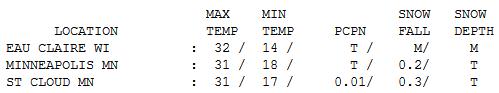
31 F. high in the Twin Cities Wednesday.
2/10ths of an inch of snow fell Wednesday in the metro area.
Trace of snow reported on the ground 7pm yesterday.
5.4" snow has fallen so far in December, 2.7" less than average, to date.
8.4" snow has fallen so far this winter season, nearly 10" less than average, to date.
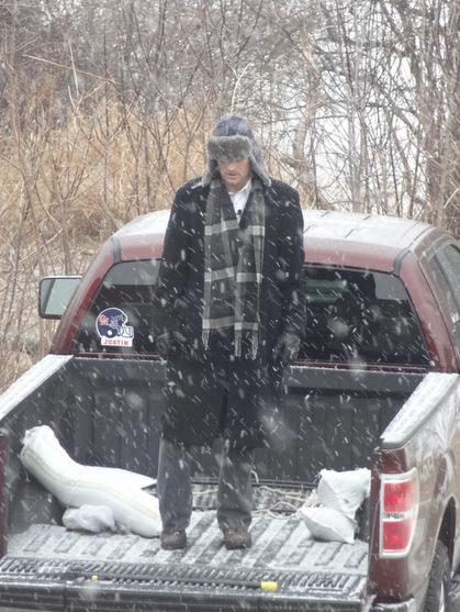
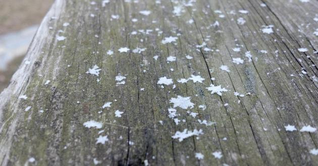
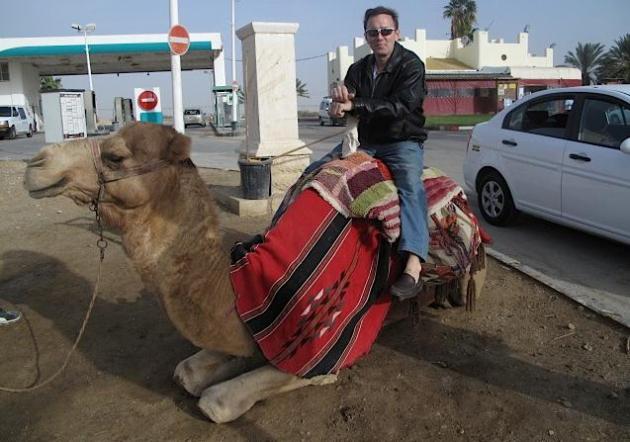
Atmospheric Magic. Check out the nearly perfect, star-shaped flakes that fell Wednesday afternoon. Thanks to WeatherNation meteorologist Katie Ferrier for sharing this remarkable photo.
"snow"/snō/
| Noun: |
| Atmospheric water vapor frozen into ice crystals and falling in light white flakes or lying on the ground as a white layer. |
|
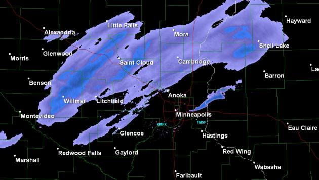
A Cosmetic Snowfall. NWS Doppler at 1:30 pm showed a 50-60 mile wide band of light snow pushing across central Minnesota, associated with a fast-moving Alberta Clipper. Snowfall amounts ranged from 2/10th of an inch in the Twin Cities to 3/10ths of an inch at St. Cloud.
62 F. high in Baltimore Wednesday, breaking the old record high of 61, set in 1956.
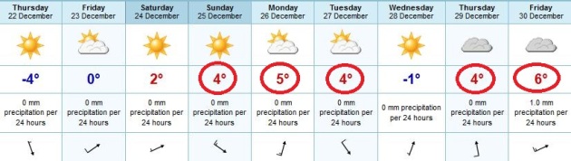
Hints Of Early November. The ECMWF (European) model is going considerably warmer than the GFS (U.S.) model for the extended outlook. The predicted highs above are in Celsius. 4 C. is 39 F; 6 C is nearly 43 F. Daytime highs from Christmas Day through the end of next week may be in the 38-43 F. range, nearly 20 degrees above average. Afternoon temperatures may briefly dip below freezing Wednesday of next week - but this forecast is pretty good incentive to think twice before venturing onto area lakes. I can't believe I'm saying this in late December.
Keep Dreaming. Yes, I'm still dreaming of a white Christmas, but I'm afraid the odds are stacked against us this year. The Rockies, the U.P. of Michigan, and parts of northern New England may have more than 1" of snow on the ground December 25, but most of America east of the Rockies will wake up to a (very) brown Christmas.
Dear Paul,
"Let's do something fun this year (if we ever get a decent snowstorm)l How about (unofficially) naming them after the early immigrants of Minnesota? Why let the hurricane states have all the fun?!"
- Dawn Hill
P.S. Perhaps you could continue through the alphabet each year rather than start anew so we could get to "Ole"
Arvid (Finnish)
Birgitta (Swedish)
Canute (Norwegian)
Dagmar (Nor.)
Eero (Finn.)
Frida (Nor.)
Gunnar (Swed.)
Helmi (Finn.)
Inglebert (German)
Janina (German)
Klaus (German)
Lena (Nor.)
Mikkel (Nor.)
Nadine (German)
Ole (Nor.) !!
Paivi (Finn.)
- No Q -
Rolf (Swedish)
Sanna (Finn.)
Thor (Swedish)
Ursula (German)
Wilfreda (German)
* photo credit above
here.
Dear Dawn -
love the idea. If we ever get a real storm again I would consider giving this a shot! The Grand Forks Herald newspaper tried this back in the 70s - named Red River storms after famous politicians and local hockey players. Yes, maybe we should give this a try. - PD
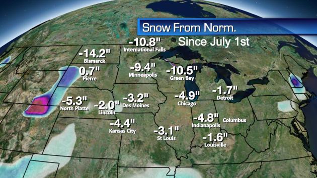
Snowfall Departure From Normal. We are in the midst of a vast snowy drought. Snowfall departures range from 10.5" below average at Green Bay to 14.2" Bismarck, nearly 11" below average at International Falls.
"There have been ten winters without a 4 inch snowfall in a calendar day going back to 1891-92 The last time this happened was in the winter of 1980-81 and before that 1967-68." - Pete Boulay, MN State Climate Office. We have yet to see a 4" snowfall so far this winter in the Twin Cities.
"
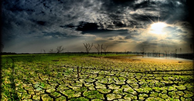
According to the Texas Forest Service, as many as 500 million trees in the state -- roughly 10 percent of the forests there -- have been killed within the last year alone as a result of 2011's bizarre lack of rainfall." - from an article below at treehugger.com.
Chugging Santa: Hey, That Doesn't Look Like Milk And Cookies To Me! Drowning his sorrows due to a lack of snow? Mrs. Claus giving him a hard time? Who knows...
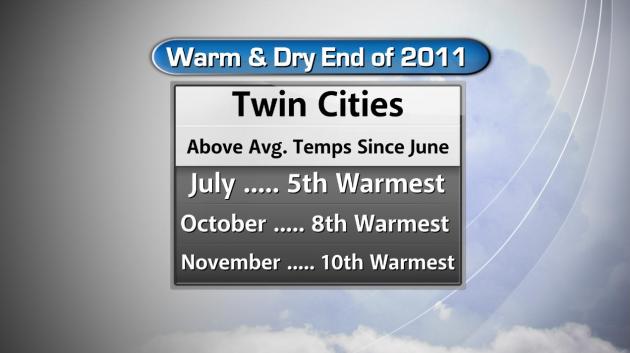
Minnesota Trends: Warmer And Drier. Graphic courtesy of Todd Nelson and WeatherNation.
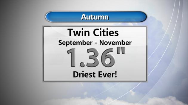
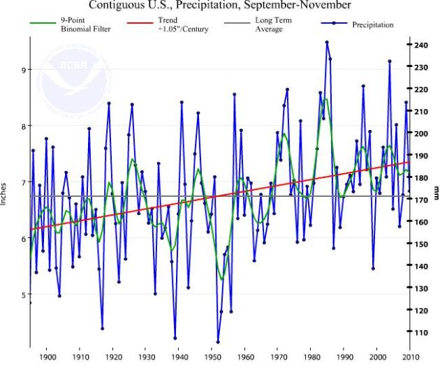
The Drought Continues. The dry rut that started back in August shows no signs of letting go anytime soon. The period September through November was the driest in Twin Cities history, with only 1.36" of precipitation.
 New Years Day, 2012
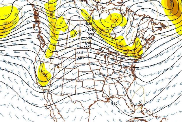
. The GFS forecast for January 1 shows a massive ridge of high pressure over the Plains states, hinting at unusually mild weather east of the Rockies. This map looks like something out of late October or early November.
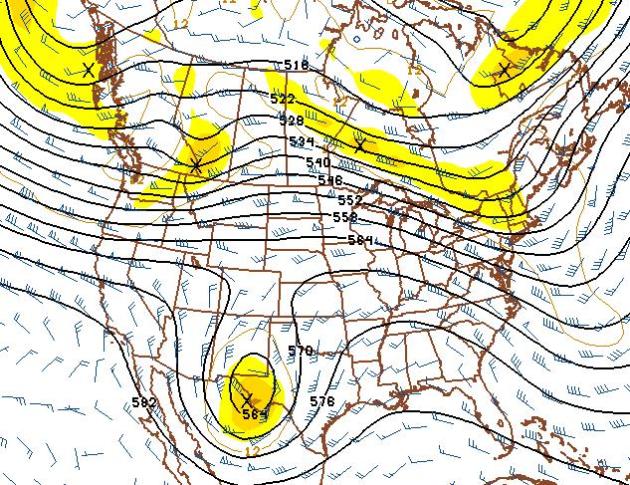 Still Waiting For Winter.
 The 500 mb (18,000) foot forecast winds for January 6 show a persistent westerly "zonal" flow through the first week of January. There's little chance of any bitter, arctic air through the first 10 days or so of January.
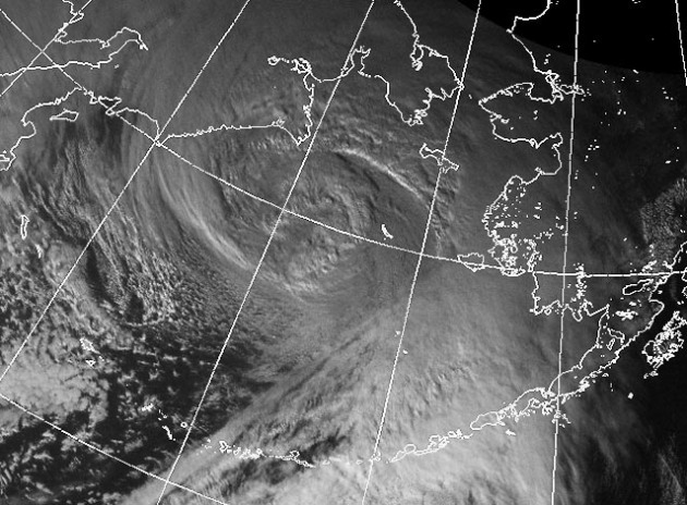
Fourth Hurricane-Force Wind Storm Blasts Anchorage Hillside. While we enjoy a quiet, dry and mild winter, Alaska has been buffeted by one hurricane-force storm after another. Obviously these aren't true hurricanes, but extremely low pressure has whipped up hurricane-force wind gusts in excess of 74 mph. The
Alaska Dispatch has a story about the impact of this parade of extreme storms on the Anchorage area: "
Once again, the Anchorage Hillside was being pounded by hurricane-force winds on Tuesday. But this time, the National Weather Service promised the nightmare should soon end for resident of the mountainous suburbs. Tuesday's hurricane-strong storm -- the fourth to hammer into the Hillside in three weeks -- appears to be the last in a string of weather monsters to march east across the Gulf of Alaska and then turn north to slam ashore in Prince William Sound before bursting over the Chugach Mountains with house-bashing force. Meterologist Dave Striklin noted that one of the last storms ripped into several houses in the Bear Valley area above the city. Bear Valley is one of the higher subdivisions in the foothills of the Chugach Front Range. Since the first storm hit on Dec. 4, Bear Valley and other subdivisions have repeatedly clocked winds in excess of 85 mph. Damage has been widespread. Homeowners have been without power several times. Trees have been flattened."
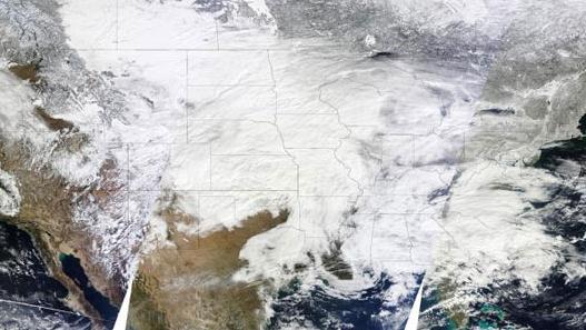
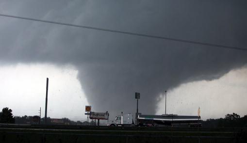
A Look Back At The Wild Weather Of 2011.
Mother Nature Network has a good overview of what was the wildest year I can recall: "
To say 2011 has been a wild weather year would be a huge understatement. From tornadoes to floods to wildfires, weather records were set across the United States this year, but not in a good way.This year the United States had a dozen deadly weather events that each caused at least $1 billion in damage, the highest total of any year on record. Most of the blame for the bad weather was pinned on La Niña, the cyclical system of trade winds that cools the waters of the equatorial Pacific (El Niño is La Niña's warm-water counterpart). La Niña can muck with global weather patterns, recurring every few years and lingering for as long as two years. This year's La Niña was one of the strongest on record."
Tornadoes Go Easy On The Weekends. Come again? Not sure you can find a real correlation between days of the week and tornado frequency, but in the spirit of full disclosure here's an interesting story, courtesy of Ars Technica and
Wired Science: "
One of the classic sci-fi doomsday machines is the weather manipulator. What better way to bend the world to your will than taking control of the weather? It seems, however, that labor regulations may have beaten mad scientists to the punch.Past studies have identified weekly cycles in a variety of weather phenomena, including rainfall, lightning, and storm heights. It’s called the weekend effect, and it’s thought to be be linked to the industrial air pollution associated with the five-day work week, though there has been a lot of discussion about the mechanics of that connection. These aren’t global analyses — many of these studies have focused on the southeastern United States during the summer months, though similar trends have been identified in other regions, as well. There’s a good reason for this. It seems that warm, moist conditions are a prerequisite for the effect to manifest."
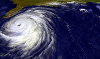
U.S. Forecaster Sees Tame 2012 Hurricane Season. It's a little early to be talking hurricanes, but based on a weakening La Nina, a couple of brave meteorologists are taking a stab at the long range forecast.
Reuters has the details: "
The 2012 Atlantic hurricane season should be relatively tame with a total of 12 named storms and seven hurricanes, a U.S. private weather forecaster said on Tuesday. Three of next year's hurricanes are expected to be "major," with sustained winds of at least 111 miles per hour, with Category 3 or greater status on the Saffir-Simpson intensity scale, Weather Services International (WSI) said in its early pre-season forecast. It said the forecast fell between the long-term average of 11 named storms, six hurricanes and two intense hurricanes and a more active recent average of 15 named storms, eight hurricanes and four intense hurricanes."
Corp Can Do Better Flood Management, Review Says.
The Argus Leader has the story: "
An independent review of the U.S. Army Corps of Engineers’ management of the Missouri River during historic flooding this year has found the Master Manual the agency uses to decide how much water to store in reservoirs in the Dakotas and Montana does allow the agency to adjust for epic flooding. But that manual is not great at predicting when that flooding will occur.“The manual is based on statistical analyses of hydrologic events, but behavior of the system is difficult to analyze or predict statistically during such large-scale flood events,” the panel concluded in its report released Tuesday. The 99-page analysis said “climatic extremes” appear to be getting “bigger and more frequent,” and advises the corps to improve its analytical model. A specific suggestion is to make sure the epic flooding of 2011 is included in the model."
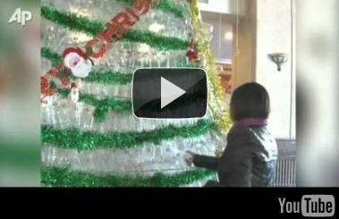
A Christmas Tree Like No Other. Check out this
YouTube clip; a Christmas tree made of 20-thousand used plastic water bottles. They did it to show concern for the environment and encourage recycling.
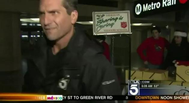
KTLA Weatherman Throws A Fit And Walks Off Camera. This probably could have been better handled off-camera, but I sympathize with this guy (having been there). Producers want the schtick of a live shot, but often weather comes second; it's an afterthought (which may not be that big a deal in L.A. - come to think of it. Here it is on
YouTube: "
KTLA morning news weatherman Henry DiCarlo throws a fit after doing a live interview and walks off without doing the weather report. Traffic reporter Ginger Chan does the next weather segment for Henry."
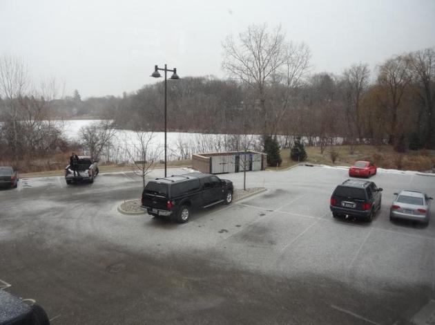
Fleeting Flakes. Yep, that was "snow" outside your window for a time Wednesday afternoon, enough to coat the ground (officially two tenths of an inch in the Twin Cities, a whopping three tenths of an inch at St. Cloud). Highs ranged from 31 in the Twin Cities and St. Cloud to 34 at Alexandria, 5-10 degrees above normal.
Paul's Conservation Minnesota Outlook for the Twin Cities and all of Minnesota:
TODAY: Blue sky, seasonably cool. Winds: NW 10-15 High: 26
THURSDAY NIGHT: Mostly clear and cool. Low: 15
FRIDAY: Sunny, breezy and milder. High: 31
CHRISTMAS EVE: Plenty of sun. Unseasonably mild. Low: 17. High: 35
CHRISTMAS DAY: Feels more like Thanksgiving out there - intervals of sun, well above average. Low: 20. High: 40
MONDAY: Unusually sunny and mild. Low: 23. High: 41
TUESDAY: Generous sun, still quiet. Low: 22. High: 38
WEDNESDAY: Intervals of sun, slightly cooler. Low: 21. High: 33
Snow Rage!
There is a 98.6 percent probability that you either love our mild, snow-free pattern - or hate it with a passion. A significant number of Minnesotans are just plain ticked off by a brown December.
Tuesday evening, in the parking lot of Target in Chanhassen, a guy slowed down and rolled down his window. "Hey Paul, are you going to give my kids some snow for Christmas?" He was scowling, and when I offered up an apologetic "no" he drove away in a huff. PS: I'm just the messenger. I like snow too, preferably on trails and ski slopes, not the Crosstown.
We're past the Winter Solstice; we pick up 3 minutes of additional daylight by December 31. The coldest air of winter (historically) is just about a month away. Will this be an abbreviated, truncated, fleeting winter? It's starting to look that way.
In spite of La Nina, jet stream winds aloft have been incredibly persistent, blowing in mild air from the Pacific; the biggest storms sailing well south of Minnesota. As I feared, the drought that began in August is spilling over into winter.
Get ready for 40 F. Christmas Day; in fact the GFS model hinting at 40s the first few days of 2012. Really. Storms? Um, what's a "storm"?
Texas Drought May Have Killed 500 Million Trees. That's an astonishing number;
treehugger.com has more details: "
Forests are among the most long-established habitats on the planet, forming their delicately balanced ecosystems over centuries -- and a new study in light of Texas's ongoing drought proves how quickly they can be decimated. According to the Texas Forest Service, as many as 500 million trees in the state -- roughly 10 percent of the forests there -- have been killed within the last year alone as a result of 2011's bizarre lack of rainfall. To make matters worse, the massive die-off may just be the first in a long line as climatologists predict more severe drought to come as climate change worsens over the next century. Forestry officials recently surveyed trees throughout 63 million acres of drought-riddled Texas and say what they found that months of record heat and stiflingly arid conditioned have left anywhere between 100 million to as many as half-a-billion trees dead. Texas Forestry Service directory Tom Boggus calls the findings "very shocking", adding that they've witnessed "a significant change in the landscape." Photo above courtesy of
freerepublic.com.
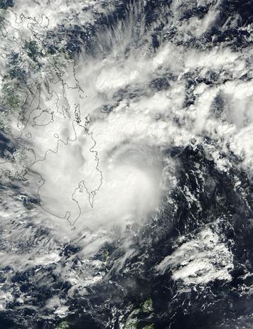
Philippines Disaster May Have Been Worsened By Climate Change, Deforestation. The story from
mongabay.com: "
As the Philippines begins to bury more than 1,000 disaster victims in mass graves, Philippine President Benigno Aquino has ordered an investigation into last weekend's flash flood and landslide, including looking at the role of illegal logging. Officials have pointed to both climate change and vast deforestation as likely exacerbating the disaster. "We have no desire to engage in finger-pointing or to assign blame at a time like this. Yet, we have an obligation to find out exactly what has happened," Aquino said, according to the Christian Science Monitor."
Don Shelby: Probe Into Climate Scientists' Stolen E-Mails Gets Serious. The Op-Ed from
Minnpost.com: "
The investigation into the stolen emails from climate scientists in 2009 has suddenly gotten quite serious. It shuffled along under the guidance of a small UK police force for two years. Now Scotland Yard and the U.S. Department of Justice have joined the hunt for cyber criminals. In 2009 thousands of email from one of the most prestigious universities conducting global-warming science was hacked by criminals. I say criminals because stealing emails is a crime — a cybercrime. The Hadley Climate Research Unit (HadCRU) and East Anglia University server’s firewalls were breached. The target was apparently a scientist named Dr. Phillip Jones. Because he communicated by email with scientists all over the world, dozens of other scientists’ emails were stolen in the heist. Then, the hackers released most of the emails to the public."
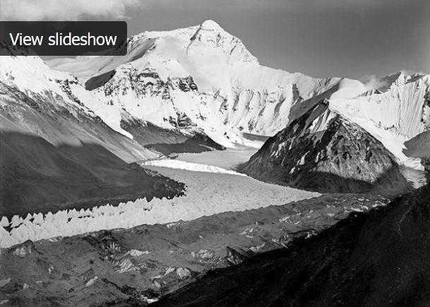
Before And After: Tracking Climate Change Through Shifting Glaciers In The Himalayas. Here's an eye-opening story (and slideshow) from
WBUR-FM, Boston's NPR radio station: "
Glaciers in the Himalayas have shrunk by as much as a fifth in the last three decades, according to the Nepal-based international Centre for Integrated Mountain Development. This is thought to be the most comprehensive assessment of Himalayan ice melting to date. David Breashears says the rapidly melting glaciers in the Himalayas are a huge problem because 40 percent of the world’s population relies on rivers that are fed by the glaciers. Breashears is trying to draw attention to the melting glaciers through photography."
Autumn Precipitation Trends In The USA Since 1900. Data shows a steady increase in fall rain and snow - courtesy of NCDC, the National Climatic Data Center in Asheville, North Carolina.


Hey Paul! Great facts and stats! Question? I live in Duluth, we are running a 20 inch snowfall deficit. If what you foresee in our weather comes true with cold air sending storms south through Feb. Can record snowfall deficits happen? I think so if were already so dry and some people are talking no or little snow I think its big possibility. Duluths least amount of snow was 39.3 in the late 60's. I think widespread wildfires will happen in the summer if this happens with the drought continued into spring. I hope I'm wrong on this, the soil is so dry before all this and it looks like its going to get worse before it gets better.
ReplyDeletePS I also want to add we have had a dry winter it seems every 4 years in Duluth, and keep up the great work!
ReplyDelete