FRIDAY: Cold and quiet start. Lots of sun early, then increasing clouds through the afternoon. High: 30
FRIDAY NIGHT: Snow develops, mainly across southeastern Minnesota. Low: 25
SATURDAY: Shovelable/plowable snowfall continues, mainly across southeast Minnesota. The Twin Cities looks to get clipped with some light stuff, could be worth of some light shoveling/brushing in the southeast Metro. High: 34
SUNDAY: Lingering flurries possible very early, otherwise a sunnier start with a cloudier afternoon/evening as another clipper drops south of the International border. Could see some light snow/flurries late. Low: 19. High:29
MONDAY: Breezy, feels like December! Few scattered light snow showers possible early. Low: 18. High: 20
TUESDAY: Cold sunshine, brisk wind chill. Low: 10. High: 20
WEDNESDAY: Still cold, increasing PM clouds. Low: 9. High: 25
THURSDAY: Partly sunny, flurries possible. Low: 14. High: 22
Excelsior, MN
I snapped this picture on Thursday after a little light snow early December morning. This pond has MUCH less water than it normally does, but now wonder since the MSP Airport had only 1.36" of liquid since September 1st. It was officially the DRIEST FALL ON RECORD with a deficit of 5.92" during the Fall period (September - November). A thin glaze of ice covering on area lakes and ponds was enough to snow the light snow and strong enough now to hold those Canadian Honkers. If you look closely, you can see them... these must apparently be the stragglers that missed the first flight out of town!

One of the strongest Santa Ana wind events in the last 5 to 10 years took place this week across southern California. A reporting station at Henninger Flats, near Pasadena, clocked winds at 157mph. Trees and power lines were downed all across the state with several hundred thousand people reported without power at one point. The winds were also strong enough to knock power out at the LAX Airport for about an hour, causing flight delays and cancellations.
The system that created this mess is actually the same system that will be bringing a wintry mess to parts of the Upper Midwest by the weekend. This is a classic "Texas Hook" or "Panhandle Hook" storm that drags copious amounts of Gulf of Mexico moisture north as it hooks around northern Texas into the Upper Midwest. Models and consistently kept the heaviest moisture in southeast Minnesota Friday night through Saturday, the Twin Cities only gets clipped with some light stuff.
The MSP Airport only had 1.36" of liquid this Fall (September - November), which is officially the driest Fall on record. Why do I feel that the current drought will only get worse before it gets better... Somebody turn off the MSP deflector shields!
Aggressive Winds Hit California
This is a quick hit from the Associated Press on the strong winds that hit southern california


Incredible Wind Gusts:
Here are some of the highest wind gusts I saw across California:
Highest Gusts in California:
- Passes/Valleys
- 76 mph - Acton
- 72 mph – San Rafael Hills (just NE of Los Angeles)
- 69 mph - Sierra Rotors Site (near Independence)
- 68 mph – Santa Fe Dam
- 66 mph – Mojave
- Ridges
- 167 mph - Henninger Flats (near Pasadena) **Suspicious Ob**
- 150 mph – Mammoth Mountain
- 106 mph – Grey Butte
- 106 mph – Five Mile
- 101 mph – Mt. Washington
Strong Winds Blow Semi Over

Colorado Winds & Snow
This video is from Steamboat, CO where heavy winds and snow created quite a stir once again.

Strong Wind Set Up
The picture below shows southern California with overlaid lines of equal air pressure (isobars). The tighter these lines are together, the stronger the winds get. I'd say the isobars are pretty close, yea? A strengthening storm system drifting into Arizona and a high pressure system to its north put a very tight squeeze on the atmosphere. The result was then a very strong wind event across the southwest. It was one of the strongest in the last 5 to 10 years.

Holiday Gift Idea
I had to share this when I saw it! It's a life-size teddy bear from vermontteddybear.com
It's a cool $299 buck-a-roos, but WOW, what a gift that would be. I guess you can put adult size pajamas on this thing...

Smart Phone App Idea
How about a winter weather survival app for your Iphone or Android. This from NDSU

Snowfall Chances
Yes, we're still watching the snow chance for Friday night - Saturday. It looks like heaviest is going to be southeast of the Twin Cities, but there still appears to be a little light snow across the southeastern side of the Twin Cities Metro.
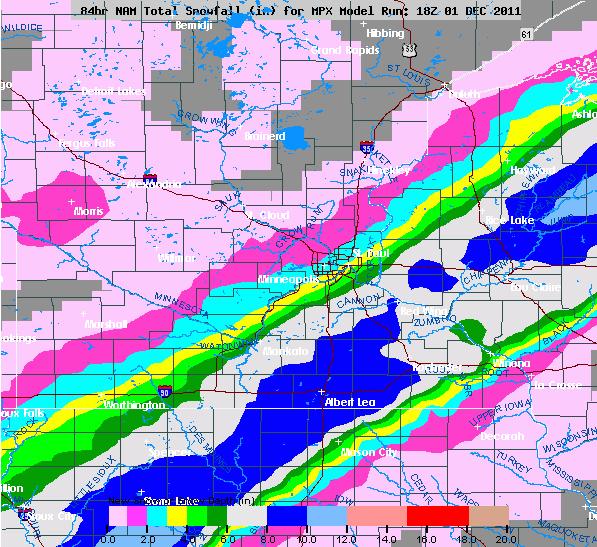
NAM MODEL
This model is gungho on the snow across SE MN and comes a little closer to home.
GFS MODEL
This one keeps the heaviest snow even farther south and only a light dusting across most of the Cities

I think both of these models have the right idea keeping the heaviest snow southeast of the Twin Cities, but I also think we'll get a little out of this, especially on the southeastern side of the Metro. I expect some winter weather headlines to show up down to our south... stay tuned!
Thanks for checking in and don't for get to follow me on Twitter

Meteorologist Todd Nelson
No comments:
Post a Comment