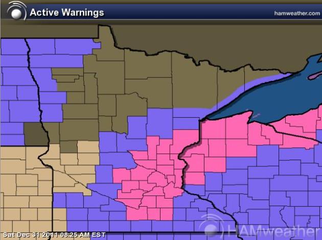
Storm track has shifted, looks like more snow will develop on the storms colder side... It could be a wintry New Years - stay tuned for more updates! A WINTER STORM WARNING has been issued for the Metro from 6pm Saturday thru 6am Sunday. Rain quickly changing over to snow will have some accumulations across parts of the state. It's not a major snow event, but wind whipped snow may reduce visibilities quite a bit overnight and cause slippery spots. KEEP THIS IN MIND IF YOU'LL BE TRAVELING/PARTYING TONIGHT!!
**PREVIOUS UPDATE BELOW**
_____________________________________
Todd's Conservation MN Outlook for the Twin Cities and all of Minnesota:
NEW YEAR'S EVE: Unseasonably mild. Mostly cloudy with a little light PM Rain. Rain/snow mix develops later. High: 39. Winds: SSE 10-15mph turning SSW 20-30mph late.


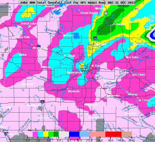
A Quick Look At Snow Totals
This is an early look and would like to see the updated runs this morning to see how things change (which they likely will) - however, 1" to 3" of snow may be possible across the area with isolated higher amounts as you get closer to Duluth on I-35. The most important thing about the snow is that it'll be blowing around quite a bit with the heavy winds expected through the night.
Stay tuned for further updates today... I'll have more by mid to late morning after the new model runs come out. Do expect this forecast to change as any 50 mile track north, south, east or west could take the accumulating snow that way. For now, it appears we'll have a somewhat wintry New Years!
Meteorologist Todd Nelson
_____________________________________**PREVIOUS UPDATE BELOW**
_____________________________________
Todd's Conservation MN Outlook for the Twin Cities and all of Minnesota:
NEW YEAR'S EVE: Unseasonably mild. Mostly cloudy with a little light PM Rain. Rain/snow mix develops later. High: 39. Winds: SSE 10-15mph turning SSW 20-30mph late.
SATURDAY NIGHT: WIND ADVISORY. Light rain/snow mix turns to light snow. Windy and colder. Low: 19 Winds: WNW 20-30mph gusts to 45mph
NEW YEAR'S DAY: WIND ADVISORY. Still windy and much colder with more clouds than sun. Passing flakes. High: 24 (wind chill in the teens and single digits). Winds: NW 15-30mph gusts to 45mph.
MONDAY: Coldest day in sight. Bright sun, less wind - a rare colder-than-average day. Low: 8. High: 18. Winds: N 5-10mph turning S 5-10mph late.
TUESDAY: Cold start. Fading sun, light snow up north. Low: 4. High: 25
WEDNESDAY: Partly sunny, a bit milder. Low: 15. High: near 31
THURSDAY: Mild sun. Feels like March again. Low: 18. High:37
FRIDAY: More sun and still very mild. Low: 20. High: 39
The old adage that statest, time goes faster the older you get, sure does seem to hold some truth. I am a father of two amazing boys, my oldest is 2 and a half years and my youngest is 4 months. To say that my wife and I are busy, is an understatement. I give credit to all the single parents out there, not sure how you do it. Although sometimes I'd like to fast forward through the harder baby moments of getting little sleep, I have to remind myself that in a few years, I might be wishing for these days back.
It's all in perspective, another year comes to a close and many of us are scrambling for a New Year's Resolution. As my late father used to always tell me, "Yesterday's history, tomorrow's a mystery, but today is a gift!" I guess those are good words to live by, maybe my 2012 resolution is easier than I thought.
Happy New Year's Eve! Can you believe that we're talking a little light rain for the end of December? Whatever falls will quickly change to light snow as a clipper blasts through. A windy and colder new year will make way for a cold Monday, one of the coldest days in sight. However, the 40s may return next week... Geesh, what month is it?
Snow Reports From Friday
A little light nuisance snow on Friday only added up to a couple/few inches (at most) in spots along the Red River Valley down to the Minnesota River Valley. There were a few light snow reports south of the Metro, but nothing to write home about.

Here are the top 20 snowfall reports from the Minneapolis and La Crosse, WI National Weather Service Offices.

Lighter Amounts in the Twin Cities
Why did the Twin Cities miss out on the snow? 2 reasons, a slight shift in the track of the finicky clipper system kept the accumulating snow just south and west of the Metro. Also dry air near east central Minnesota kept the snow from falling for several hours while the clipper moved southeast. You can see the dry in air by looking at the image below... there literally is a 'hole' over the Metro where snow was not falling.

What's Next?
Our New Year's Eve will consist of another clipper system scooting through the area. This time, temperatures will be warm enough (low 40's) for a little rain during the onset of the precipitation. If the moisture hangs around long enough, we could see it switch over to a little snow, which now looks to bring more snow to the Twin Cities. Northeastern Minnesota looks to get some accumulations too. Another note, with temperatures falling through evening, I'm a little concerned with some slippery or icy spots that may develop. Be advised that roadways could become slippery with any rain/snow mix that continues through the evening.

Snow Accumulations Up North
This is a glance at how much snow could be pumped out across far northern Minnesota

Ringing In the New Year With Big Winds!
The one thing you will notice with this system is the ridiculous winds developing through the afternoon, lasting right through New Years Day. As the intensifying low pressure system slides east, we'll get blasted on its backside with 30 to 40mph wind gusts, perhaps even up to 50mph!
**Impacts**
Unsecured lawn ornaments and light weight objects left outdoors will be blown around. Small branches may break off trees causing power outages and high profile vehicles may have trouble on area roads and highways.

Much Colder Into 2012
The big story to start off the new year, weatherwise, will be the much colder air settling into place. In fact, temperatures on Monday will be below normal for a change! Teens for highs and single digit lows will make it feel like January
Mild Saturday

Colder Sunday (New Year)

Just When You Thought Winter Finally Arrived...
Just when you thought winter finally arrived, think again. The extended forecast looks warm once again. Temperatures may surge back into the 40s by the end of the week!

That's all for now, thanks for checking in and enjoy the last of 2011!
Meteorologist Todd Nelson
No comments:
Post a Comment