35 F. high in the Twin Cities Monday.
26 F. average high for December 20.
-24 F. record low for December 20.
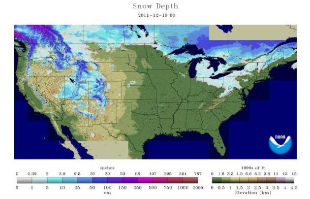
0" snow depth at KMSP.
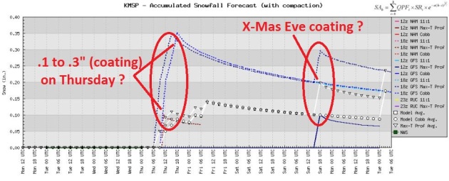
Coating of snow possible Thursday, again Christmas Eve.
2006: last "brown Christmas" in the Twin Cities (less than 1" snow on the ground December 25).
A Mild December. Here are average temperatures for the month of December as of the 19th:
Twin Cities: +4.0 F.
Duluth: +3.7 F.
International Falls: +4.6F.
Rochester: +2.6 F.
St. Cloud: +5.6 F.
"
Oddly, in Washington, D.C., you're four times more likely to have somebody drive into you on purpose than anywhere else on the planet."- AutoVantage official Michael Bush in an article on road rage from MPR below. Photo:
geek.com.
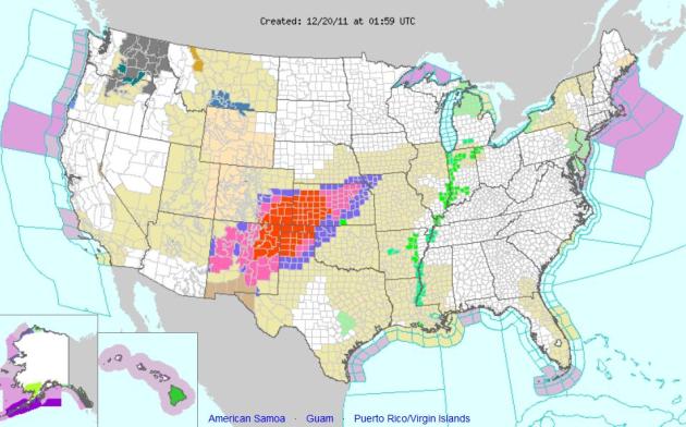
Blizzard Conditions Southern Plains. Here are current watches/warnings for the USA. The storm shutting down highways from New Mexico into cenetral Kansas will push eastward, sparking mostly rain east of the Mississippi River. Another storm pushing across the Great Lakes and Ohio Valley late week could spark snow for major urban areas of the northeast on Christmas Eve. The latest watches/warnings/advisories from NOAA are
here.
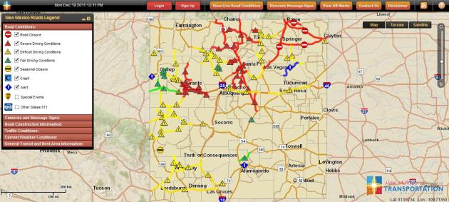
Colorado, Interstate 25 is closed from south of Pueblo down to the NM State Line
Colorado, US 160 is closed from Trinidad to Springfield
Colorado, US 287 is closed from Lamar down to the OK State Line
New Mexico, Interstate 25 is closed from Santa Fe to Raton, at CO border (170 miles)
New Mexico, Interstate 40 is closed from east of Albuquerque to TX border (130+ miles)
New Mexico, U.S. Routes 54, 56, 60, 64, 285 are all closed in North & East NM
Texas, Blizzard conditions north & west of Amarillo, US routes 62, 87, 287, 385 are closed.
Oklahoma panhandle, Cimarron County and Texas County are reporting white-out
conditions with slick and hazardous driving conditions. Travel is being discouraged.
Now seeing U.S. Highways closed in southwest Kansas into Oklahoma panhandle:
US 54 is now closed Westbound from Liberal, KS into Oklahoma Panhandle
US 160 closed from Johnson City, KS (Stanton County) west to CO State Line,
"due to blizzard conditions, zero visibility and stuck vehicles"
* thanks to James Aman from Earth Networks for
 Snowstorm Batters Southwest: Holiday Travelers Brace
. Here's the latest on the snowstorm from the
Christian Science Monitor: "
Call it an early white Christmas for residents from Santa Fe, N.M., to Dodge City, Kan. Meteorologists are calling for a powerful storm to intensify through the day, dumping 6 to 12 inches of blowing, drifting snow. By tonight, travel in places like Liberal, Kan., Dalhart, Texas, and maybe even Amarillo, Texas will be difficult and dangerous. If there is any good news about the storm, it is that weather forecasters expect it will start to lose its winter-weather characteristics as it heads east. This will make it easier for procrastinators to get to the malls before Christmas. And, it appears the storm will not cause a major disruption of air travel except perhaps some delays later on Monday in places like Dallas and Houston, which could get some thunderstorms."
Photo credit: "
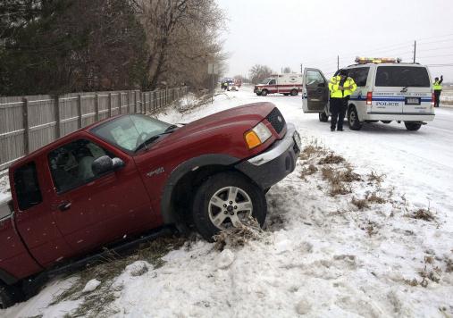
Longmont police respond to three separate weather-related accidents as snow falls on Colo. Hwy. 66 at Francis Street in Longmont, Colo., on Monday, Dec. 19, 2001. A major storm is bringing blizzard conditions to Colorado's southeastern corner, where ranches and farms have been hit hard by drought. (AP Photo/Longmont Times-Call, Richard M. Hackett) BOULDER DAILY CAMERA OUT; COLORADO DAILY OUT."
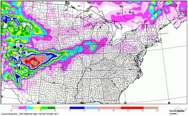
Predicted Snow Into Christmas Eve. It's odd to think that some towns over the Texas Panhandle may wind up with a white Christmas, while many northern cities over the Upper Midwest experience the first brown Christmas since 2006.
A Christmas Coating For The Twin Cities? Any snowfall amounts later this week will be meager, models hinting at a light snowy coating Thursday, again Christmas Eve. There may be a snowy dusting for Santa's arrival, but I still doubt we'll have enough snow to qualify as a white Christmas (1" or more on the ground).
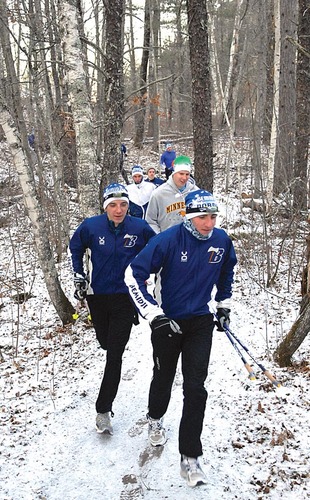
Things To Know For Winter Outdoors Activities.
The Bemidji Pioneer has some helpful reminders and tips:
-- A list of snowmobile and ski trail conditions is available online at
www.dnr.state.mn.us/snow_depth/index.html.
-- The Minnesota Department of Natural Resources recommends staying off of ice that is fewer than 2 inches thick.
-- An ice thickness of at least 4 inches or more is considered generally OK for ice fishing or other activities on foot, and 5 inches or more for snowmobiles or ATVs.
-- All cross-country skiers who are 16 years of age and older who are using ski trails in state parks or forests or on Grant-In-Aid trails must carry a signed Minnesota ski pass. For details visit
www.dnr.state.mn.us/licenses/skipass/index.html.
* photo above courtesy of the Bemidji Pioneer.
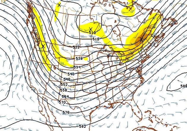
Looking More Like Winter. The 500 mb map above is valid January 4, and it shows a southward shift (and phasing) of the jet stream. No more split flow keeping us dry, whisking sloppy storms off to our south. This shift in the pattern should favor a return to much colder weather in January, with a better chance of significant snowstorms. The question: will there be so much cold air rushing south that the favored storm track remains south/east of Minnesota. The honest answer: too early to tell. But I keep thinking "don't buck the trends". Go with "persistence", which translates into go with the flow - which is considerably drier than normal, and has been ever since August. At some point this dry rut will turn around, but when is anyone's guess at this point.
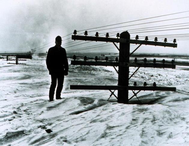
Photo Of The Day: "Think It'll Snow?" This remarkable photo of snow, so deep it almost buried utility lines, was taken by Bill Koch, at the North Dakota Highway Department. Photo courtesy of the collection of Dr. Herbert Kroehl, NGDC.
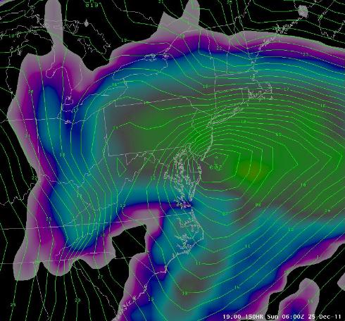
Christmas Nor'easter? The ECMWF is hinting at a significant storm off the coast of New Jersey Saturday, a potentially intense storm tracking right up the east coast, capable of coastal rain, flooding and beach erosion, with potentially heavy wet snow just inland from D.C. to Philadelphia to the suburbs of New York and Boston. If you're traveling to the northeast next weekend stay tuned for the latest updates.
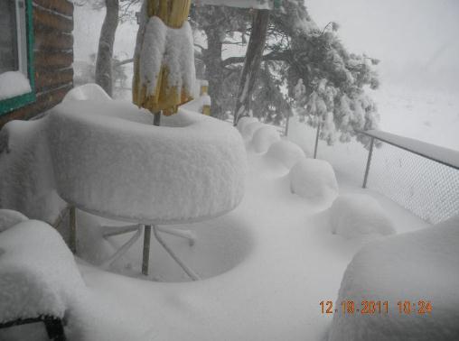
Smothered In Snow. As much as 2 feet of snow has been reported in Catron County, New Mexico. Photo courtesy of meteorologist John Smith and Twitter.
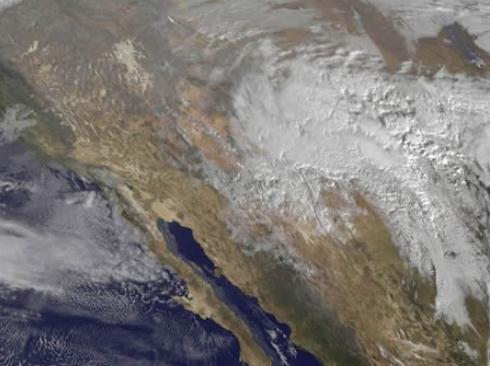
Southern Storm From Space. This visible satellite image is courtesy of NASA, showing the comma-shaped swirl dumping heavy snow and ice from New Mexico to Kansas.
Snow Closing Roads Across Northern New Mexico. Click
here to see a graphical representation of all the roads shut down due to blizzard conditions - especially northeastern New Mexico. Map courtesy of NMDOT.
No Snow Is Big Relief For Flooding. We're saving money on snow removal, heating our homes, fewer weather-related traffic accidents, and if this (dry) trend continues, it may lower the risk of spring flooding.
The Argus Leader has more: "
One of the snowiest Decembers on record last year in the Northern Plains and Rocky Mountains set the initial conditions for the epic flooding on the Missouri River this past summer. While plenty of opportunity remains for snow to fall this winter and rain next spring, what the region has accumulated so far is nowhere near the snowpack that existed at this time last year.“If you compare the plains snowpack this year versus last year, in much of North Dakota and South Dakota, we had a couple of inches of water on the ground already in the way of snowpack,” South Dakota Climatologist Dennis Todey said. “This year, we have marginal to no snowpack across all the plains.”
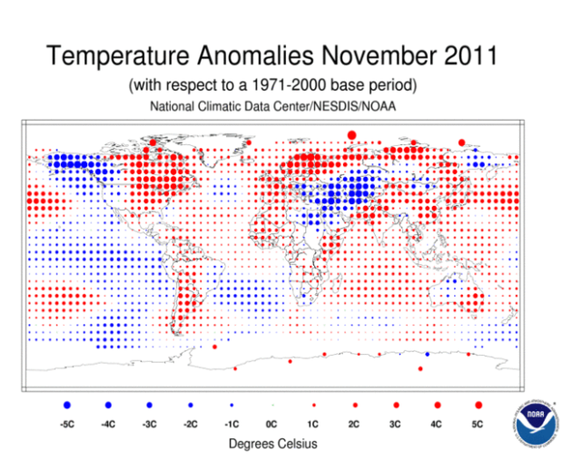
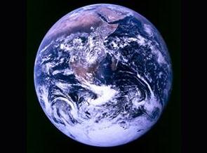
November: 12th Warmest On Record For Earth. Here's a
press release from NOAA: "The globe experienced its 12th warmest November since record keeping began in 1880. Arctic sea ice extent was the third smallest extent on record for November at 11.5 percent below average. Additionally, La Niña conditions continued throughout the month. According to NOAA’s Climate Prediction Center, La Niña is expected to continue through the winter.
- The combined global land and ocean average surface temperature for November 2011 was the 12th warmest on record at 55.81 F (13.35 C), which is 0.81 F (0.45 C) above the 20th century average of 55.0 F (12.9 C). The margin of error associated with this temperature is +/- 0.13 F (0.07 C).
- Separately, the global land surface temperature was 1.10 F (0.61 C) above the 20th century average of 42.6 F (5.9 C), making this the 16th warmest November on record and the coolest month since February 2011. The margin of error is +/- 0.20 F (0.11 C). Warmer-than-average conditions occurred across central and eastern North America, Northern and Western Europe, northern Russia, most of China and the Middle East, southeastern Australia, and southern South America. Cooler-than-average regions included Alaska, western Canada, much of Eastern Europe, Kazakhstan, and southwestern Russia.
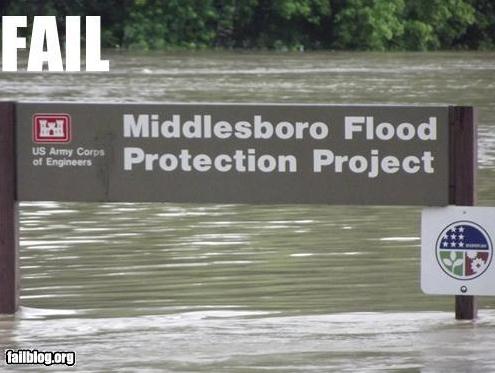
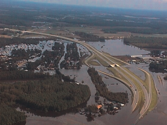
Flood Fix Would Cost $4 Billion. Is it worth $4 billion to protect residents of the Red River Valley from a 1-in-500 year flood?
The Jamestown Sun has the story: "
The Red River Valley can protect itself from a 500-year flood event, at a cost of about $4 billion. That investment would buy about $12 billion in protection, essentially the estimated damages from a 500-year flood event, according to a two-year study — Red River Basin Long Term Flood Solutions — which the Red River Basin Commission recently completed. The RRBC study outlines a path to reducing peak flood flows in the basin by 20 percent. Engineers have determined that the devastating Grand Forks-East Grand Forks flood of 1997 could have been prevented, had flows been reduced by 20 percent." Photo above courtesy of NOAA.
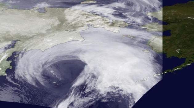
Alaska's Storm Listed Among Most Significant Events For November. The
Alaska Dispatch has the story: "
That massive “extratropical cyclone” that walloped Bering Sea and Northwestern Alaska communities with high winds and blizzard conditions last month was named one of the eight significant climate events to strike the United States in November, according to NOAA’s latest update. “Winds gusted to over 80 mph and the storm surge topped 8 feet, marking the strongest storm to impact the region in decades,” NOAA said. Other startling U.S. weather developments that month included a tornado that struck Oklahoma, record warmth in some New England states and the third most active hurricane season on record. "
Photo credit: "
Captured by the NOAA-19 satellite's AVHRR sensor, the storming bearing down on Alaska is seen in this infrared imagery on November 8, 2011 at 1400z. The storm is predicted to bring hurricane force winds and surge through the Bering Strait. Coastal flood warnings are in effect for much of western Alaska. Because of Alaska's high latitude, geostationary satellite do not provide adequate coverage. Polar-orbiting satellites like NOAA-19 are required to monitor severe weather in such areas. However, polar-orbiting satellites acquire imagery as swaths as they orbit around the planet. The area outside of the swath is visible in this image. NOAA satellite image. Courtesy: Alaska Dispatch.
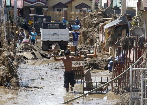
Nearly 1,000 Dead In Philippines Flooding. Here's an update from Reuters and the
Chicago Tribune: "
MANILA (Reuters) - Nearly 1,000 were killed when flash floods and landslides caused by Typhoon Washi swept through riverside and coastal villages in the southern Philippines late last week, the national disaster agency said on Tuesday. The agency said 957 were killed and 49 were missing, with most of the casualties coming from the cities of Cagayan de Oro and Iligan. The previous death toll was 650."
Photo credit: "
Residents affected by Friday's flash flooding clean up their damaged homes in Iligan city in southern Philippines Monday, Dec. 19, 2011. With funeral parlors overwhelmed, authorities in a flood-stricken southern Philippine city organized the first mass burial of unidentified victims who were swept to their deaths in one of the worst calamities to strike the region in decades. (AP Photo/Bullit Marquez)"
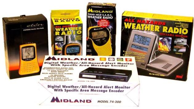
Is NOAA On Your Shopping List? Nothing says Merry Christmas and Peace On Earth like a NOAA Weather Radio, right? Seriously. If you don't have one of these nifty radios (that will turn on at 2 am if a tornado is coming toward your county) you may want to consider asking Santa for one. More details from
NOAA: "This year, give your loved ones something a little outside the gift box! Give the gift of safety and peace of mind. We’ve rounded up some worthy gift ideas to help make life go a little more smoothly:
* NOAA Weather Radio All Hazards: These
life-saving radios broadcast immediate warnings about tornadoes, floods, AMBER Alerts — even things like chemical spills in your area. You also can turn them on anytime to get your local weather conditions and forecasts. The radios are available at electronic stores, marine supply stores, mail order catalogs and online. Prices vary by model and options, but typically range between $20 and $80.
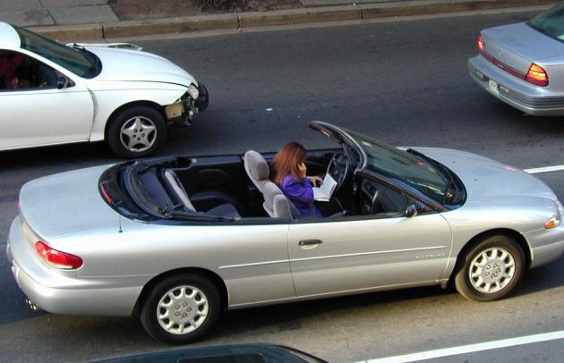
Road Rage: A Symptom Of Much More Than Bad Traffic? MPR has a very interesting story: "
It's not unusual for awful traffic conditions or incompetent driving to make some people really angry behind the wheel. But when enraged drivers actually lash out at others on the road, that's road rage — and experts say it can be a sign of deeper emotional problems. The term road rage was coined in Los Angeles – a city long known for its epic freeway jams. Mike Shen got a taste of how bad it can get shortly after moving to L,A., when a woman viciously tailgated him on the freeway. "She got so angry that she started pacing me to my right," Shen says. "She wasn't looking at the road, she was literally yelling — out the window — racial epithets at the top of her lungs." (this is one of my favorite photos, possibly the most terrifying picture I've ever seen. I believe the woman in the photo was driving, while reading a book and talking on her cell phone. Where are the State Police when you really need them?)
IBM Says We'll Have Mind-Reading Computers Within 5 Years.
Mashable.com has the story: "
Keyboards and mice may seem like clunky artifacts of the past within the next five years, pushed aside in favor of the ultimate user interface: the human mind. That’s according to IBM
, which just published its “5 in 5″ forecast
: a prediction about five innovations that will fundamentally change our world within the next five years. The most head-turning prediction: we’ll be able to use the power of our minds to operate machines. This isn’t telepathy, so those hoping to get a real-time stream of thoughts from an individual had best look to shows like Heroes or Bablylon 5. What IBM envisions is using a simple brain-machine interface (BMI) that can detect different kinds of brainwaves and tell a computer to respond a certain way."
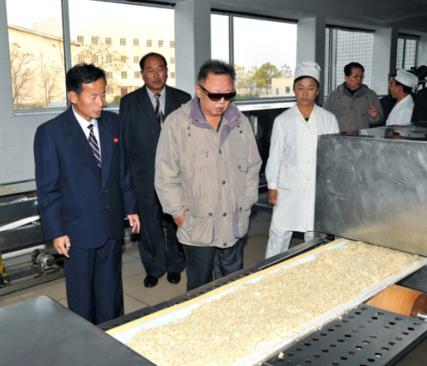
Kim Jong-Il "Looking At Things". In honor of the "Great Leader's" passing I thought I'd share a
special retrospective from Tumblr: "
the dear leader liked to look at things. updated every other day and sometimes on the weekends too."
 Cooling Off
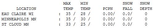
. Clouds gave way to a clearing trend on Monday as temperatures fell through the 30s into the 20s. Daytime highs ranged from 31 at Alexandria to 33 St. Cloud, and 35 in the Twin Cities.
Paul's Conservation Minnesota Outlook for the Twin Cities and all of Minnesota:
TODAY: Plenty of sun, a bit milder. Winds: S 5-10. High: near 30
TUESDAY NIGHT: Clear to partly cloudy, seasonably cool. Low: 18
WEDNESDAY: Clouds increase, risk of a thaw. High: 32
THURSDAY: Few flurries or snow showes (coating?), then gradual clearing, colder. Low: 19. High: 26
FRIDAY: Cool sunshine, good travel weather. Temperatures near normal for late December. Low: 12. High: 24
CHRISTMAS EVE:: Chance of a dusting of flurries. Heavier snow for Chicago, Milwaukee and Detroit? Low: 14. High: 28
CHRISTMAS DAY: Windblown flurries. First brown X-Mas since '06. Low: 16. High: 26
MONDAY: Patchy clouds, few flakes. Low: 14. High: 25
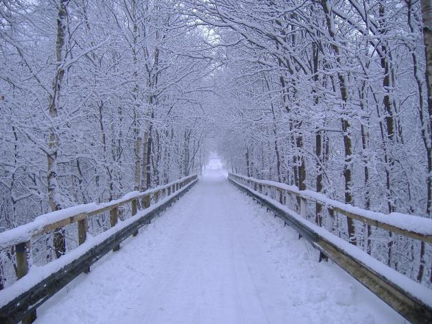
Snow Drought of 2011
"Now is the winter of our discontent" Bill Shakespeare complained. Snow lovers are feeling blue - shocked by an expansive smear of brown in every direction. Few are on the fence. "After last winter we deserve a break" a friend confided. "But please don't print my name, OK?" It's not a perfect correlation but I've found age to be a big factor. Most younger residents are mourning the lack of snow, while older Minnesotans are elated. "No slipping, no sliding, no worries about sprains or broken hips!" an older doctor-buddy quipped.
Snow lovers take heart: January is now the snowiest month of the year. But if the dam bursts and bitter air finally does surge south, the storm track may be pushed too far south for significant snow. Again, when in a drought, don't predict rain (or snow).
No subzero nights yet, either. During a typical winter the metro experiences an average of 30 nights below 0. The last winter we saw that many numbing nights was 1996 (43 nights). Last winter: 18 subzero nights, but 86.6" snow made it SEEM colder. I'm starting to think we'll see half that much snow this winter.
A cool, dry week, brown Christmas, 40s on New Year's Day? Looks like Tulsa (with lakes).
Pair Of NASA Studies Reaffirm Impact Of Global Warming.
The State Column has the story: "
NASA officials have released a pair of new studies showing that global warming could lead to a major transformation for Earth’s plants and animals over the next century. New research into the Earth’s paleoclimate history by NASA’s Goddard Institute for Space Studies director James Hansen suggests the potential for rapid climate changes this century, including multiple meters of sea level rise, if global warming is not abated."
Rush Limbaugh: "Climate Misinformer Of The Year". According to
Media Matters: "
In 1994 Rush Limbaugh declared, "There is no global warming going on," adding that scientists "admit" they "may need 20 years more data to prove it." Since then, Limbaugh has managed to shield his brain from 18 years of mounting evidence that humans are changing the climate. "Science has made enormous inroads in understanding climate change and its causes," according to the National Research Council's latest report assessing the state of climate science. "There is a strong, credible body of evidence, based on multiple lines of research, documenting that climate is changing and that these changes are in large part caused by human activities," the report said."
TedxPSU: Michael Mann: A Look Into Our Climate, Past To Present To Future. Check out this
16:00 YouTube video for a good overview of the science of climate change - and how it's been turned into a political football: "
Michael Mann is a professor in the College of Earth and Mineral Sciences, a climatologist, and the director of the Earth System Science Center at Penn State University. Michael is best known for his extensive background and research in the field of paleoclimatology. This work led to Michael's graph of temperature trends over the last thousand years, popularly coined as the "hockey stick graph" because of its resemblance to the sporting equipment. The graph has received acclaim and criticism since its publishing. He has received many awards and honors including, but not limited to, the Outstanding Scientific Paper Award by NOAA in 2002 and also was named one of the 50 Leading Visionaries in Science and Technology by Scientific American. Michael is also one of the founders of RealClimate.org, a highly acclaimed climate science website that was chosen in 2005 as one of the top 25 "Science and Technology" websites by Scientific American and as one of the top 15 "green" websites by Time Magazine in 2008. Michael's educational background includes an M.S. degree in Physics from Yale, and a Ph.D. in Geology & Geophysics from Yale."
Do The Uninformed Kill Progress on Stopping Climate Change? Climate change is a complex topic; many people continue to confuse climate change with weather. In the end it comes down to trusting climate scientists. More from
treehugger.com: "
First of all, kudos to Iain Couzin and his team at Princeton for an elegant bit of research using shiner fish to validate computer models exploring the effect of the uninformed population on consensus when opposing minority interests threaten to doom decision making. But more importantly: if you have been asking yourself how it is possible that humankind still does nothing to curb global warming in the face of massing, irrefutable evidence on the urgency of action, this research might point to the answer. Couzin first reported results from computer models in the journal Nature in 2005, and has continued the development of these models since then. But the models produced counterintuitive results. "The classic view is that uninformed or uncommitted individuals may allow extreme views to proliferate. We found that might not be the case," Couzin notes."


No comments:
Post a Comment