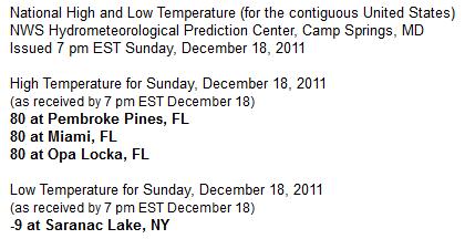
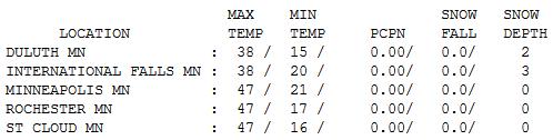
47 F. high in the Twin Cities Sunday.
26 F. average high for December 18.
17 F. high on December 18, 2010, one year ago yesterday.
61 F. high at Montevideo Sunday afternoon.
60 F. at Mobridge, South Dakota Sunday afternoon, setting an all-time record high for December 18.
No significant storms in sight through the end of 2011.
32 F. predicted high on Christmas Eve (colder on Christmas Day with flurries).
40 F. possible New Year's Eve/Day in the Twin Cities, almost 20 degrees above average.
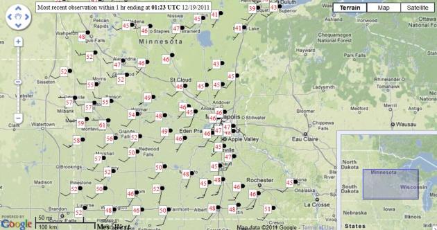
Indian Summer - On December 18? I thought I had seen a lot living in Minnesota for 27 years. But I can't remember the last time I saw 60-degree warmth on December 18. Highs ranged from the mid/upper 40s in the Twin Cities metro to 46 at St. Cloud to upper 50s over west central Minnesota. Montevideo gets the coveted Golden Thermometer Award, registering a balmy high of 61! Map courtesy of
Mesowest.
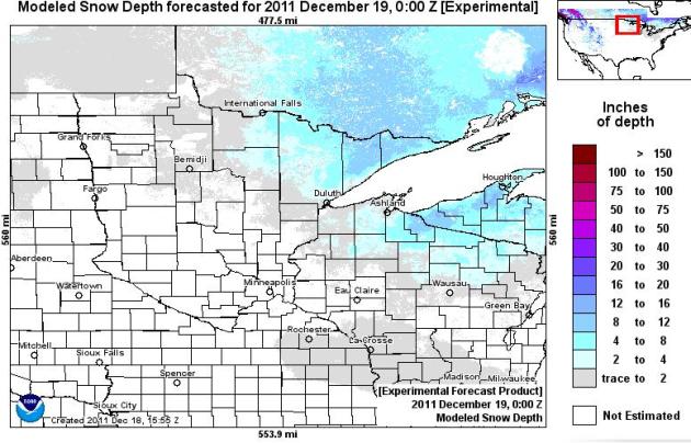
A Dearth Of Snow Across Minnesota. True, nights have been cold enough for area ski resorts to be making snow - but there's precious little (natural) snow on the ground - 8-12" for the Boundary Waters, a coating of slush for Rochester and far southeastern Minnesota (from Friday night's clipper), but that's pretty much it. Click
here to see a map of Minnesota snowcover, courtesy of NOAA.
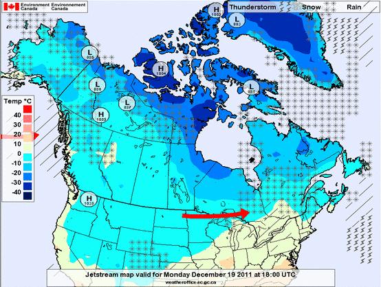
In Search Of Cold Air. Midday temperatures on Sunday across much of southern and western Canada were in the 25-33 degree range - you have to venture north of Hudson Bay to find temperatures in single digits and teens. Map courtesy of
Environment Canada.
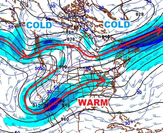
Why So Mild? An unusually persistent west-to-east "zonal" flow blowing from the Pacific is keeping much of America unusually mild (and snow-free). The jet stream (above) is featuring a class "split flow", a southern branch forcing mostly Pacific air across the Lower 48, while the northern branch to the jet is staying well north of the border - keeping the coldest air of winter dammed up well to our north. If and when those two jets "phase" or combine, conditions will be ripe for more major storms (and a better chance that arctic air will finally charge southward into the USA). That may happen sometime in mid January - but I don't see any major shift in the pattern through the first few days of January. It's amazing how persistent this pattern has been - a far cry from last winter.
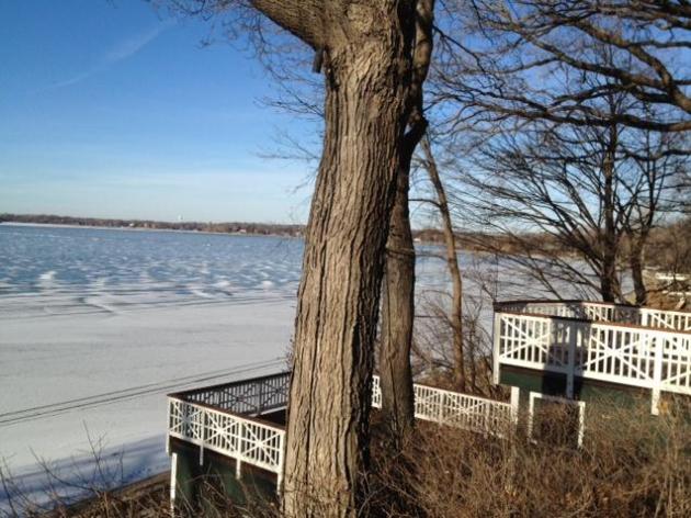
Unstable Ice. This was the scene on Tonka Bay, on Lake Minnetonka, yesterday afternoon. The ice looked anything but stable and firm with temperatures pushing into the 40s. It felt more like early November than mid December out there - just a few piles of dirty snow left.
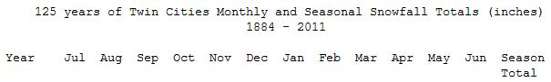
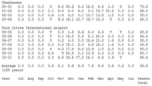
Twin Cities Snowfall Since 2000. Look at the column on the far right - amounts have been extremely variable: 86.6" last winter, but only 40.7" the previous winter, and a meager 25.5" the winter of 2004-2005. It seems like all or nothing, with a handful of extra-snowy winters (2001, 2004 and 2011), but most winters since 2000 less than 45" of snow. This upcoming winter? Place your bets, but I'm starting to think less than 50". Check out 125 years of Twin Cities winter snowfall, month by month
here, courtesy of the Minnesota State Climate Office.
* The 125 year snowfall average is 45.6", but the rolling 30-year average is closer to 56".
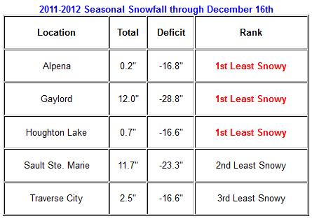
Least Snowy Start To Northern Michigan. Here's a
special statement from the National Weather Service: "
It seems inconceivable that northern Michigan is off to another painfully slow start to winter snowfall. Yet, here we are. This is the third consecutive year in which very little (or no) snow fell in November, with the general lack of snow continuing into December as well. Many locations throughout northern Michigan are now bordering on (or have reached) their least snowy starts to winter in recorded history. The table below speaks volumes about just how little snow has fallen across the area so far this winter."
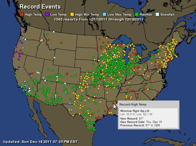
One Mixed Up Weather Map. Here is a week's worth of records across the USA, from December 11-18. All the green dots are record RAINFALL amounts, red dots are record maximum temperatures, yellow dots record nighttime lows. Much of America is experiencing unusual warmth, with temperatures 15-30 degrees above average. Map courtesy of NOAA and
Ham Weather.
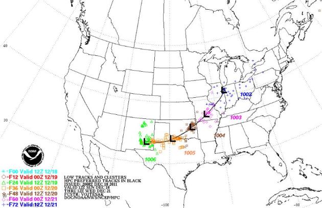
A Meager (Southerly) Storm Track. A lack of big temperature extremes will limit just how strong this week's storm can get, but a Texas storm is forecast to track toward Chicago, putting down a narrow carpet of slushy snow.
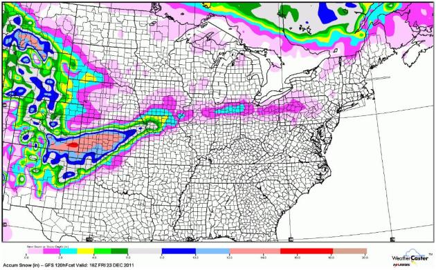
Predicted Snowfall Through Friday. The GFS model through midday Friday shows accumulating snow from Kansas into northern Missouri, a little slush possible south of Chicago - but any significant amounts will be limited to the Rockies and Ontario, Canada.
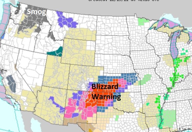
Upside-Down Weather Map. Let me get this straight: 61 yesterday at Montevideo, Minnesota, while the panhandle of Texas braces for blizzard conditions? Very odd. This next storm will pass well south of Minnesota Tuesday, brushing Kansas City with a couple inches of slush, maybe 1" or so for the southern suburbs of Chicago. NOAA's latest watches and warnings
here.
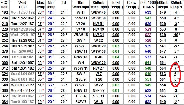
40-Degree New Year? It's still 11-12 days away, but the latest GFS model is predicting temperatures at 850 mb (about 3,500 feet above the ground) around +8 C, close to 50 degrees. That may translate into low 40s here at the surface on New Year's Eve and New Year's Day. I keep waiting for the other shoe to drop - there's some evidence that we may see a real wintry swipe after January 3 or 4 (highs in the teens and 20s). Nothing subzero - yet.
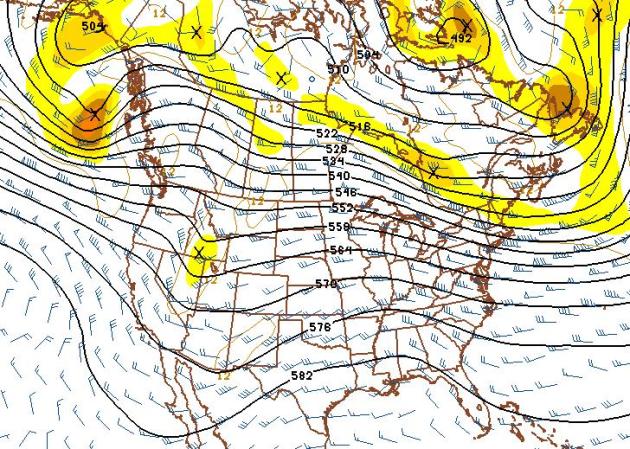
New Year's Day, 2012. If you were to just call up this map, and not look at the date, you'd swear this is a 500 mb (18,000 feet) map from late October or maybe early November. But January 1? The core of the jet stream is still forecast to be howling over southern Canada - a pattern more typical of mid Autumn. Map courtesy of NOAA NCEP.
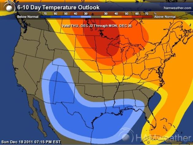
Balmy Bullseye. CPC, The Climate Prediction Center, shows temperatures much above normal across Minnesota and much of the Upper Midwest through December 26. Map courtesy of NOAA and Ham Weather.
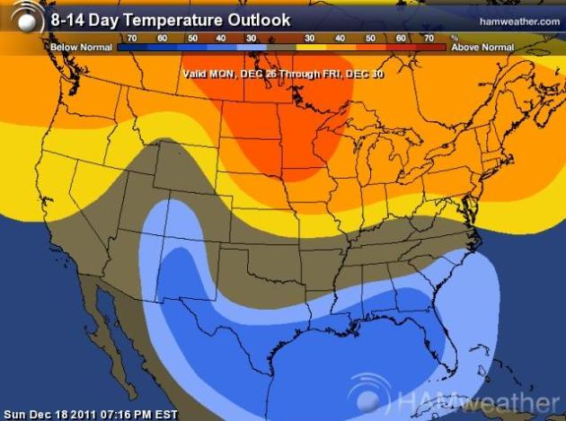
Trending Warmer Through The End Of 2011. The longer-range, 8-14 day outlook through December 30 shows a continued warm bias, thanks to a persistent "zonal", west to east flow. No dramatic shift in the pattern - yet.
Hundreds Killed As Flash Floods Hit Philippines. The soggy remnants of a tropical storm took an unusual path over the southern Philippines, catching many by surprise. The
Sydney Morning Herald has a full report: "
AT LEAST 521 people are dead and nearly 500 missing after tropical storm Washi devastated a wide swath of the southern Philippines. Flash flooding turned two coastal cities into a muddy wasteland filled with overturned cars and uprooted trees. Defense Secretary Voltaire Gazmin and top military officials were flying to the worst-hit city of Cagayan de Oro to help oversee search-and-rescue efforts."
Photo credit: Cristio Tingson, foreground, talks on his cell phone as workers use a backhoe to search for victims of his buried house Sunday, Dec. 18, 2011 at Iligan city in southern Philippines. Tropical storm Washi blew away Sunday after devastating the southern Philippines with flash floods that killed hundreds of people as they slept and turned two coastal cities into a muddy wasteland filled with overturned cars and uprooted trees. Rescuers dug up eleven bodies but not Tingson's wife and three children. (AP Photo/Bullit Marquez)
Typical For Early November. The high of 47 in the Twin Cities Sunday was the average high for November 6. Redwood Falls saw 50, temperatures were close to 60 over west central Minnesota, near Madison and Canby. Amazing.
 Photo Of The Day: "Tropical Sunrise"
. Thanks to Bay Scroggins who sent in this terrific sunrise from Miami. I feel bad for all those Florida and Arizona snowbirds who can't gloat about "all the cold and snow Minnesota is experiencing". In fact Arizona has seen considerably more snow so far this winter season than Minnesota.
 Michael Buble Christmas Duet
. If you missed SNL Saturday night you owe it to yourself to check out
this skit - one of the funniest I've seen in a long time. That's Michael up above teaming up with Justin Bieber (Jimmy Fallon). I
almost fell off the sofa when they got to Lady Gaga.
Paul's Conservation Minnesota Outlook for the Twin Cities and all of Minnesota:
TODAY: Sunny, turning cooler. Winds: NW 10-15. High: 31
MONDAY NIGHT: Mostly clear and seasonably chilly. Low: 16
TUESDAY: Clouds increase, storm stays south. High: 28
WEDNESDAY: Patchy clouds, light snow up north. Low: 17. High: near 30
THURSDAY: Plenty of sun, a quiet weather pattern. Low: 18. High: 28
FRIDAY: Blue sky, good travel weather. Low: 15. High: 29
SATURDAY: Mix of clouds and sun, relatively mild. Brown Christmas Eve. Low: 16. High: 32
CHRISTMAS DAY: Colder, few passing flurries. Low: 19. High: 28
A Cincinnati December
I was at a Christmas party Saturday night when a new Minnesota transplant blurted out "this is just like Cincinnati. My friends back in Ohio wouldn't believe it - like I never left!" He's right.
Last year it wouldn't stop snowing. This year we can't buy a fistful of flakes.
What happened? True, it's a La Nina winter (which often favors colder and snowier). But we're quickly learning (the hard way) that not all La Ninas are created equal. Other factors are in play, including a persistent and powerful wind flow howling from the Pacific. Normally winds aloft shift around from southwest (major snowstorms) to west (dry and mild) to northerly (pulling in arctic air). There is variety and variation from week to week. But this "zonal" west to east pattern has dominated our weather, keeping any bitter air locked up near the Arctic Circle. I keep waiting for the "polar vortex" (subzero air) to break off and migrate across Canada. It should have happened by now.
The map looks like Halloween, not Christmas. What will it take for a major snowstorm? A fresh outbreak of arctic air, which I don't see through early January. We cool off a little this week; dry roads for our (very brown) Christmas.


No comments:
Post a Comment