26 F. high in the Twin Cities Friday.
27 F. average high for the Twin Cities on December 16.
40-43 F. predicted high for Sunday in the metro area.
50 F. possible Sunday over far southwestern Minnesota, about 20-25 F. warmer than average.
.2 to .8" snow possible Thursday night into Friday - a coating of snow is possible for Christmas Eve.
20s expected Christmas Eve and Christmas Day (little chance of accumulating snow).
40 F. possible New Year's Day (GFS model).
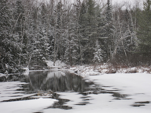
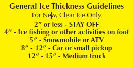 Think Twice Before Venturing Onto Area Lakes
. With highs near freezing today and low 40s tomorrow already unstable ice may thin out even more. Ice on many area lakes is still not safe - be careful out there.
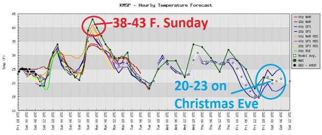 Mild Weekend
, Then Cooling Back Down To "Average". Models are pretty unanimous:
near freezing later today, topping 40 tomorrow, then chilling back down to near 20 by Christmas Eve.
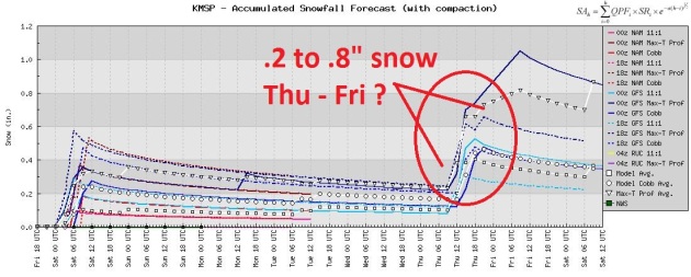 Dry Into Thursday - Nuisance Snow Late Week?
 Models are suggesting a coating of snow late in the week - if we don't have at least 1" snow on the ground by Sunday we'll see the first brown Christmas since 2006 in the Twin Cities.
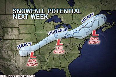
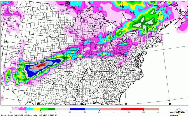 Snow Potential Next Week
. The next storm will track well south/east of Minnesota, laying down a stripe of significant snow from the Texas Panhandle to Kansas City, with an inch or two possible for Chicago and the suburbs of Detroit.
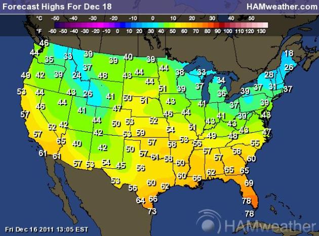
December or October? I can't quite decide, staring at these predicted highs for Sunday. No bitter air (anywhere), a zonal, west to east flow direct from the Pacific sparking temperatures 15-30 degrees above average, especially over the northern tier states. Amazing. Map courtesy of NOAA and
Ham Weather.
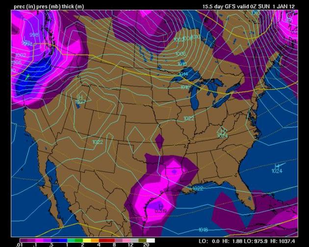
Winter On Hold. Here is the GFS forecast for New Year's Day - showing the rain-snow line ("540 line") stretching from north of Seattle to Duluth to Albany. It will be warm enough for rain across most of America, with the exception of northern New England. You would expect to see a map like this in mid or late October, not January 1.
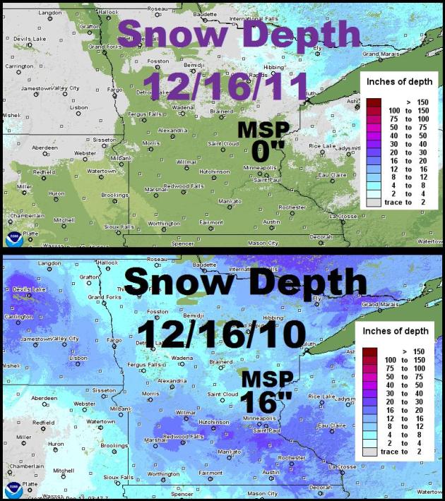
What A Difference A Year Makes. NOAA snowcover maps show the stark, dramatic difference in snowcover from December 16, 2010 to December 16, 2011. A year ago we had 16" snow on the ground - another snowfall would bring the snowcover up to 19" in time for Christmas. This year: little more than a trace of flurries is expected.
Snow Potential Next Week.
AccuWeather.com has a good story focusing on the potential for accumulating snow next week. A white Christmas is possible from Chicago and Detroit into portions of northern New England. "
The best chance for snow will be on the far northern tier, from the higher ground of northern New York to northern New England, where enough cold air will be in place at the beginning of the storm. Heavy accumulations are not out of the question, and it is likely that there may be a white Christmas for the far northern mountains of New England."
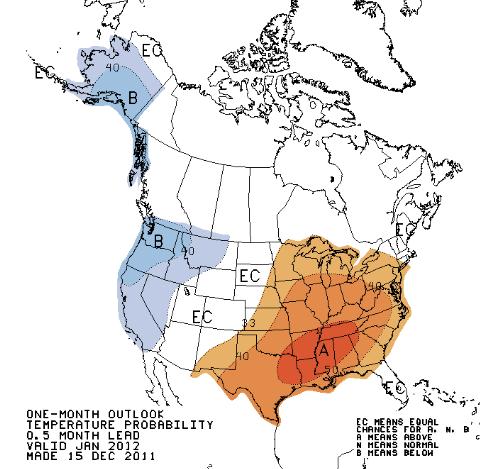
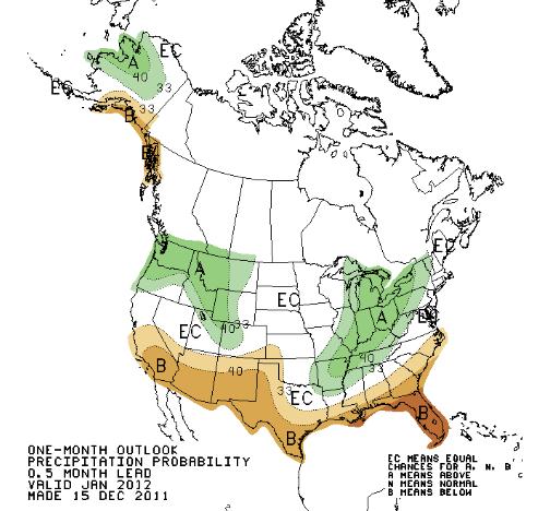
New January Outlook. The new 1 month outlook is out from NOAA's CPC (Climate Prediction Center) unit, and it shows a significant shift in thinking. Warmer than average temperatures are predicted from the Plains to the east coast, a bias toward colder, stormier weather for the far western USA. Wetter than average conditions are predicted for the Pacific Northwest, the Great Lakes and Ohio Valley, a dry bias over the far southern USA.
"Debt crises here in the U.S. and Europe overshadowed this alarming fact: 2011 ranks as the worst ever for catastrophic economic losses from disasters, says reinsurance company Swiss Re." - from an article at Fox Business below.
2011 Record Year For Disaster Costs.
Fox Business has the details: "
Debt crises here in the U.S. and Europe overshadowed this alarming fact: 2011 ranks as the worst ever for catastrophic economic losses from disasters, says reinsurance company Swiss Re. The reinsurer says 2011 losses could still grow, due to expected winter storms in Europe and incoming claims from the ongoing floods in Thailand. Ranked as the five costliest insured disasters for the year, in this order, were: Japan’s deadly earthquake and tsunami; New Zealand’s earthquake; floods in Thailand, and two deadly tornadoes in the U.S.; Hurricane Irene ranked number six; floods in Australia came in seventh; and storms in the U.S. took the remaining three spots out of the top 10. The US was the worst hit, as the country posted six of the top 10 most costly insured disasters in 2011."
RANKING OF 2011’S MOST COSTLY INSURED DISASTERS
1) Japan’s earthquake, tsunami, $36 BN insured losses
2) New Zealand earthquake, $12 BN
3) Thailand floods, up to $11 BN
4) US tornadoes, Alabama et al, $7.3 BN
5) US tornadoes, Missouri et al, $6.7 BN
6) Hurricane Irene, $4.9 BN
7) Australia floods, $2.3 BN
8) US storms, $2 BN
9) US storms, $1.5BN
10) US storms, $1.4BN
* list courtesy of Swiss Re and Fox Business.
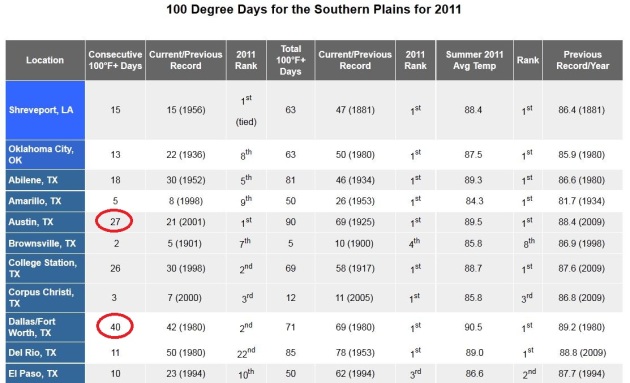
2011: One Scorcher Of A Year. The southern region of the National Weather Service put together a summary of 100-degree heat earlier this year. Austin reported a record: 27 consecutive days above 100. Dallas experienced 40 days above the century mark, coming very close to shattering an all-time record. Even more important:
check out the Summer 2011 Avg. Temp column. Many cities experienced the warmest summer on record, dating back to the late 1800s. More details
here.
Texas Drought Takes Cow Numbers Down By 600,000. The story from
CBS-TV in Dallas: "
The worst drought in Texas’ history has led to the largest-ever one-year decline in the leading cattle-state’s cow herd, raising the likelihood of increased beef prices as the number of animals decline and demand remains strong. Since Jan. 1, the number of cows in Texas has dropped by about 600,000, a 12 percent decline from the roughly 5 million cows the state had at the beginning of the year, said David Anderson, who monitors beef markets for the Texas AgriLife Extension Service. That’s likely the largest drop in the number of cows any state has ever seen, though Texas had a larger percentage decline from 1934 to 1935, when ranchers were reeling from the Great Depression and Dust Bowl, Anderson said."
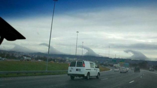
Photo Of The Day: "Wave Clouds". This is one of the more remarkable photos I've seen in recent days, an amazing example of wave clouds, triggered by an inversion (warm air above a layer of colder air near the ground) coupled with "orographic lifting", air rising up and over a series of hills - producing this very unusual sight. Thanks to Jay Vaughan who writes: "wave clouds in Birmingham taken minutes ago by friend. The original tweet can be found
here.
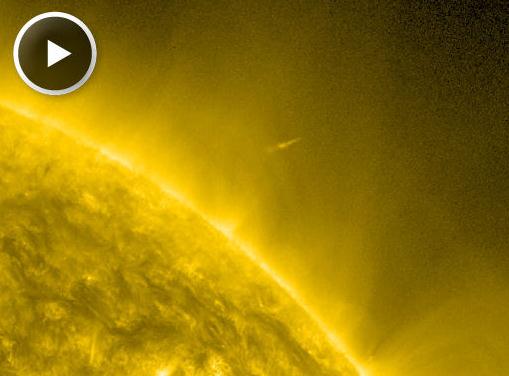
Comet Lovejoy Survives. First of all, Comet "Lovejoy"? Who names these things? Wow. Here's the latest (and an amazing animation) from
spaceweather.com: "
Incredibly, sungrazing Comet Lovejoy appears to have survived its close encounter with the sun. Lovejoy flew only 140,000 km over the stellar surface during the early hours of Dec. 16th. Experts expected the icy sundiver to be destroyed. Instead, NASA's Solar Dynamics Observatory caught the comet emerging from perihelion (closest approach) at least partially intact."
Wait A Minute - The Top 3 Google Execs Have How Many Jets? The Mercury News and
Business Insider have the answer: "
Larry Page, Sergey Brin, and Eric Schmidt have eight jets between the three of them, reports Mercury News. They want to pay $33 million to help finish renovation of Moffett Federal Field, a joint civilian/military airport located between Mountain View and Sunnyvale. In exchange, they want to be able to use 2/3 of the floorspace to house their eight aircraft."
Top 10 Things You CAN Have For Christmas 2011. The techno-geeks (and I say that with all love and admiration) over at
gizmag.com have the details: "
Having taken a look at some highly desirable items that are highly unlikely to find their way under the tree this year with our 2011 list of things you CAN'T have this Christmas, it's time for a look at some of the gear that might represent more realistic shopping options this festive season. There's definitely some items on the list we wouldn't mind receiving ourselves, while others fall into the category of "for the person who has everything" ... either way, there's sure to be something for every technophile in the household."
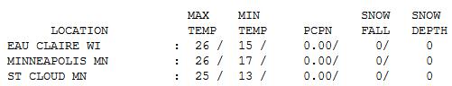
Friday Flakes. Clouds increased during the day, a burst of light snow and flurries coating roads. Yes, that was "snow" out there for a time Friday night, just a candy-coating, enough to remind all of us that it's still "winter" out there. The Winter Solstice is next Thursday, the 22nd, but "meteorological winter", marking the start of the 90 coldest days of the year, really kicked off closer to December 1. Friday highs ranged from 20 at Alexandria to 25 St. Cloud, 26 in the Twin Cities and 28 at Redwood Falls.
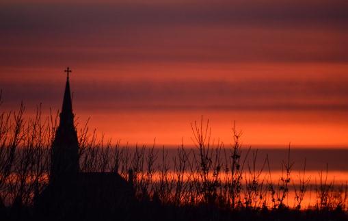
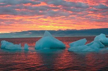
"Red Sky At Morning". Sailors take warning, right? That old proverb often works, but not this time. No significant storms are brewing, looking out the next 2 weeks. Photo courtesy of WeatherNation meteorologist Todd Nelson, who snapped this pic in St. Michael.
Paul's Conservation Minnesota Outlook for the Twin Cities and all of Minnesota:
TODAY: Icy start. More clouds than sun, flurries and snow showers over Wisconsin and the MN Arrowhead. Winds: SW 8-13. High: 32
SATURDAY NIGHT: A few clouds, dry. Low: 19
SUNDAY: Sunnier - hints of Indian Summer in the air by afternoon. High: 42
MONDAY: Plenty of sun, turning cooler. Low: 23. High: near 30
TUESDAY: Partly sunny, still milder than average. Low: 16. High: 29
WEDNESDAY: Mix of clouds and sun, quiet. Low: 19. High: 32
THURSDAY: More clouds, light snow up north? Low: 21. High: near 30
FRIDAY: Early flakes, then clearing skies. Low: 17. High: 29
CHRISTMAS EVE: Partly sunny and seasonably chilly. High:
27
CHRISTMAS DAY:
Blue sky - a few degrees colder. High:
24
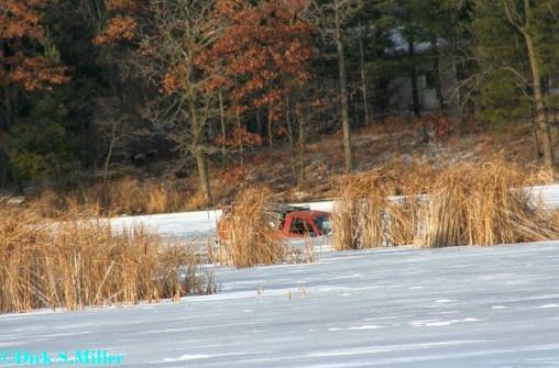
Stay Off The Ice. Dirk Miller posted this photo Thursday on the Twin Cities National Weather Service web site. It’s a photo from Rice Lake. We just had 91 hours/row above freezing, and with temperatures expected to be above freezing much of this weekend, the ice will not be thickening up (safely) anytime soon. If in doubt - stay off the ice.
A Kansas City December
Much of Minnesota is experiencing the driest autumn on record, and there's no sign of a sudden, imminent shift in the pattern. We're getting a taste of the same drought that has produced the driest conditions in Texas in 112 years of record-keeping; worse than the Dust Bowl Days of the 1930s. The U.S. just saw 6 of the 10 costliest weather disasters on the planet in 2011; the costliest year on record, according to Swiss Re.
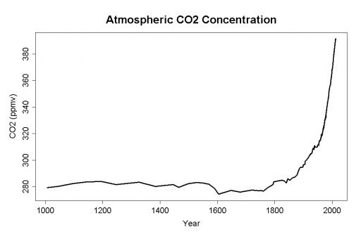
Who cares about climate change? Warmer winters sound pretty good, but the reality: some areas will get (much) wetter, while others dry out. Recent research from NCAR suggests that "most of the western two-thirds of America will be significantly drier by the 2030s." The long-range outlook is a paradox: drier overall, interrupted by more extreme rainfall events.
Another thaw arrives today with mid 30s, low 40s not out of the question Sunday. We cool off a few degrees next week, a "split flow" nudging storms well south of Minnesota. A clipper may whip up a few decorative flurries on Christmas Eve, but I still expect the first "brown Christmas" since 2006.
Long range guidance is hinting at 40 on New Year's Day. A Year Without A (real) Winter? Stay tuned.
The Climate Post: Surprise Deal Emerges At United Nations Climate Talks.
Huffington Post has the story: "
In a surprise turnaround, the United Nations climate talks managed to produce a new deal to eventually curb global emissions moving forward. In a press release announcing the agreement, the United Nations Framework Convention on Climate Change (UNFCCC) called it a "breakthrough." The new agreement marks a break from the Kyoto Protocol, which divided the world into two categories -- the developed and the developing world. Instead, said the European Union's Climate Commissioner Connie Hedegaard, the new agreement reflects "today's mutually interdependent world," and moves toward an agreement that partners all countries in combating climate change."
Britain: Computer Equipment Seized In Climate E-Mail Inquiry. The New York Times has the story: "
The British police said Thursday that they had seized computer equipment at a home in West Yorkshire as part of an investigation into the online dissemination of thousands of private e-mails from servers at the University of East Anglia in late 2009. Skeptics who challenge the science underlying global warming cited them to argue that scientists had distorted data to exaggerate the threat of global warming. Inquiries in Britain and the United States refuted that charge. The police in Norfolk said that no one was arrested in the operation, which was carried out on Wednesday."
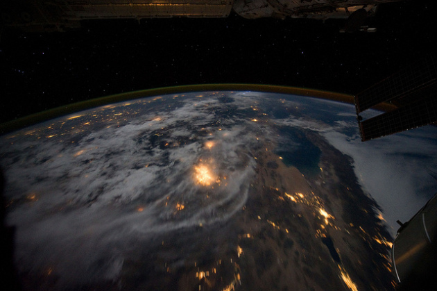
Governor Vows To Prepare California For Climate Change. The story from
AP: "
SAN FRANCISCO (AP) — The United Nations' top climate official joined California Gov. Jerry Brown on Thursday to call for renewed efforts in the state to more quickly adapt to the risks that extreme weather and a rising sea pose to agriculture and the coastline. Rajendra Pachauri, chairman of the United Nations Intergovernmental Panel on Climate Change, joined Brown, scientists, former Gov. Arnold Schwarzenegger and billionaire Sir Richard Branson at a conference at the California Academy of Sciences in Golden Gate Park. Brown organized the conference, he said, to urge people to "wake up" to extreme weather patterns caused by manmade global warming that he said are already causing damage, and to start thinking about what California ought to do to prepare for worse threats." Photo above courtesy of NASA.
 Brown Slams Global Warming Skeptic's "Cult-like Behavior"
.
NBC in the San Francisco Bay Area has the story: "
It's not a sequel to "Twins." But it is an unlikely-looking political duo. Arnold Schwarzenegger and Jerry Brown are headlining a climate change conference at the California Academy of Sciences in San Francisco. Brown, who spent much of his first year embroiled in California's budget fiasco, wasted no time today changing the subject. tossing a rhetorical bomb at skeptics of climate change. "The main thing we have to deal with in climate change is skepticism and denial, and the cult-like behavior of political lemmings that would take us over the cliff," Brown said, to the delight of his invited audience."
 More Thuggery From Deniers And Their Enablers
. More death threats for climate scientists? From The Cost of Energy at
grinzo.com: "It has come to my attention that we now have yet another example of a threat to a highly respected member of the climate science community. This time, it’s Dr. Michael Mann, and the situation is a bit more convoluted than the normal, run-of-the-mill, denier-threatens-scientist story.
First, the evidence. On Judith Curry’s blog,
one can find this piece of text:
Fifth, Mr. Matarese challenges me to support my calling him a goat buster.
Here is one quote:
"When I got a look into the e-mail communications which Dr. Mann mistakenly assumed would never get into the hands of the people he’d been so successfully defrauding and suppressing, I confess that it got my Sicilian up, and I began recalling remote locations in the Pine Barrens – well within driving distance of Centre County, Pennsylvania – where a little work with some shovels and a sack of quicklime could serve a genuine public benefit."
http://neverendingaudit.tumblr.com/post/14275878869


No comments:
Post a Comment