+2.7 F. December temperatures are running close to 3 degrees above average, to date.
7 of the first 14 days of December saw daytime highs above freezing in the metro area.
0 nights below zero so far this winter season.
91 straight hours above freezing in the Twin Cities ended at 4 am Thursday morning (tweet from Ken Barlow over at KSTP-TV).

"Not Giving Up On A White Christmas." Santa's still on his way, with or without snow on your roof next Saturday night. There's still a (slight) chance of snow for Christmas, at least according to the GFS model, which prints out .33" of liquid precipitation on Christmas Eve. Temperatures aloft should be cold enough for all snow - if (and it's a big if) this forecast verifies, it could mean 2-4" of snow. It's still 8 days away - confidence level is low, but we still have a shot...
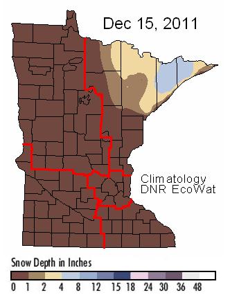
Snow Drought. The drought that began in September and October shows no sign of quitting anytime soon. I can't remember a mid December snowfall map so devoid of snow. Some 4-8" amounts are being reported over the Boundary Waters. Otherwise there's virtually no snow anywhere - statewide. Snowcover map courtesy of the MN DNR.
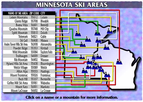
* Important reminder: it's been cold enough for local ski resorts to make snow. Skiing/snowboarding is much better than you might think. Check out the latest ski conditions here. All the resorts (below) are in the system, URL brought to you by Technical Intelligence. Pretty nifty site.
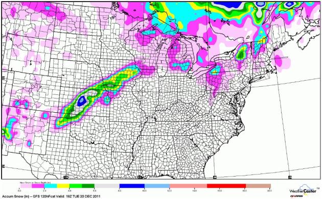
No Significant Snow Through Tuesday. The latest GFS model run prints out a snowy stripe from near Wichita to Des Moines and Waterloo next Monday night - Tuesday, the next storm passing too far south/east to impact Minnesota with accumulating snow.
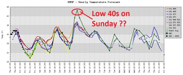
An "Easy December". Will we pay for this in January? Probably. No sense worrying about it - but we can enjoy this current (storm-free) stretch of weather. I realize it's great news for commuters and travelers; we're all saving significant money heating our homes and businesses. But tens of thousands of Minnesotans make their living with winter-related recreation, tourism, snow removal, etc - and these folks are hurting. They are NOT happy about a dire lack of snow. The latest computer mode run shows a possible temperature spike. The National Weather Service is forecasting a possibility of low 40s by Sunday afternoon, which would be 15+ degrees above average.
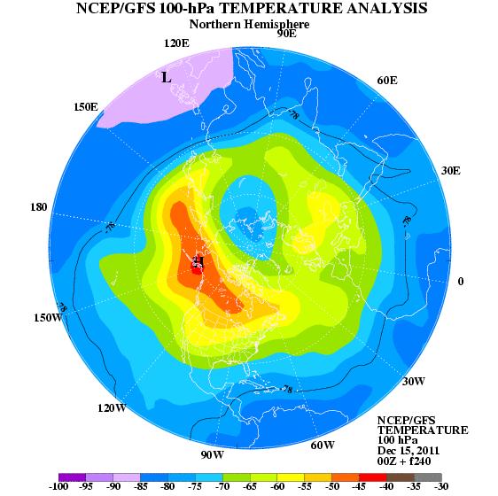
"....a stratospheric warming event starts in the high latitudes around December 22. All the models concur on this point, and if it verifies (it) would gradually translate to a strong Alaska/Yukon/NWT block with an Arctic vortex in Michigan/Ontario/Western New York State. We should see some digging of cold air into the U.S. during the last week of December.
My call for December was mainly mild, but we should have a very cold and dry January if the cAK motherlode sets up in the eastern Great Lakes. The ensembles are already giving a colder tinge late in the 6-10 and through the 11-15 day periods." - Chief Meteorologist Larry Cosgrove, WXAMERICA.
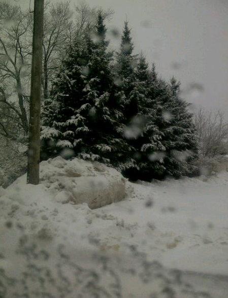
One Place With Plenty of Snow. Check out this photo from Ironwood, up on the U.P. of Michigan, enjoying plenty of lake effect snow sweeping in from Lake Superior. Photo courtesy of Geneva Cummons. Thank you for reminding us what snow looks like!
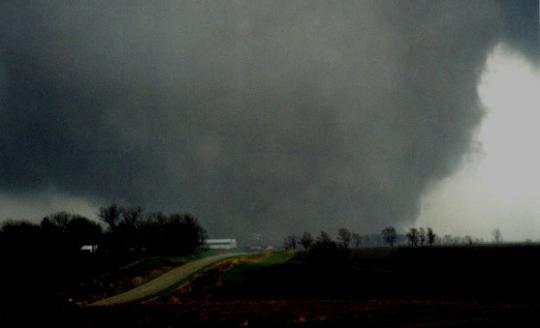
1 in 100 thunderstorms will ever go on to spin up a tornado. Less than one-tenth of 1% of all tornadoes are EF-5 in strength.
Up until 1952 meteorologists were forbidden to use the word "tornado", for fear of inciting public panic. Here is the story of the first operational (and ultimately successful) tornado forecast in the USA, on March 20, 1948, courtesy of NSSL.
SPECIAL WEATHER STATEMENT
NATIONAL WEATHER SERVICE SAN DIEGO CA
130 PM PST THU DEC 15 2011

CAZ042-043-048-050-055>058-060>062-160030-
ORANGE COUNTY COASTAL AREAS-SAN DIEGO COUNTY COASTAL AREAS-
SAN BERNARDINO AND RIVERSIDE COUNTY VALLEYS-THE INLAND EMPIRE-
SAN DIEGO COUNTY VALLEYS-SAN BERNARDINO COUNTY MOUNTAINS-
RIVERSIDE COUNTY MOUNTAINS-SANTA ANA MOUNTAINS AND FOOTHILLS-
SAN DIEGO COUNTY MOUNTAINS-APPLE AND LUCERNE VALLEYS-
COACHELLA VALLEY-SAN DIEGO COUNTY DESERTS-
130 PM PST THU DEC 15 2011

...A COLD STORM WITH FUNNEL CLOUDS IS EXPECTED THIS AFTERNOON...

A COLD STORM SYSTEM WILL CONTINUE TO MOVE INTO SOUTHERN CALIFORNIA
THIS AFTERNOON. THE COLD...UNSTABLE AIR ASSOCIATED WITH THE SYSTEM
WILL BRING THE POSSIBILITY OF FUNNEL CLOUDS TO THE AREA...MAINLY
OVER THE COASTAL AND VALLEY AREAS...UNTIL LATE THIS AFTERNOON.

STAY TUNED TO NOAA WEATHER RADIO...THE NATIONAL WEATHER SERVICE
WEBSITE AT WEATHER.GOV/SANDIEGO...OR LOCAL MEDIA FOR UPDATES.
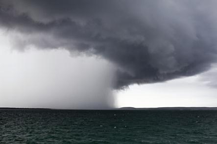
Cold Air Funnels For Southern California. An unstable airmass (cold aloft, relatively mild near the ground) created ripe conditions for cold air funnels outside L.A. Thursday. These funnel clouds rarely touch down, and on the rare occasions when they do damage is usually minimal. Even so - funnels in L.A.?
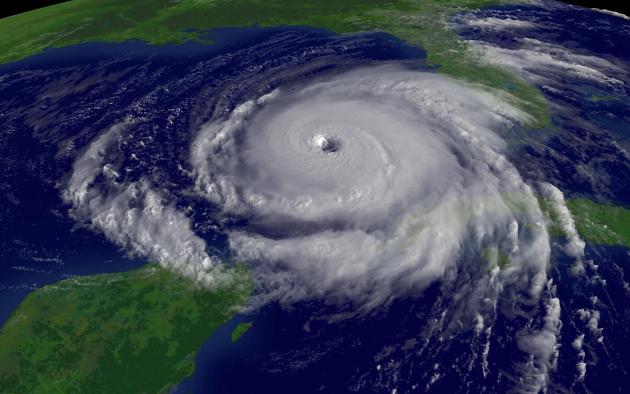
Atlantic Hurricane Predicted Delayed Until Spring. Why the delay? Because accuracy for a forecast this far out is (consistently) poor. More details from USA Today: "FORT COLLINS, Colorado (AP) – A hurricane forecast team says it will wait until spring to predict how many storms will form in the Atlantic because it hasn't found a good model to predict storms this early. Researchers at Colorado State University usually start making predictions in December. For the first time in 20 years, they're waiting to forecast the number of named storms, including hurricanes."
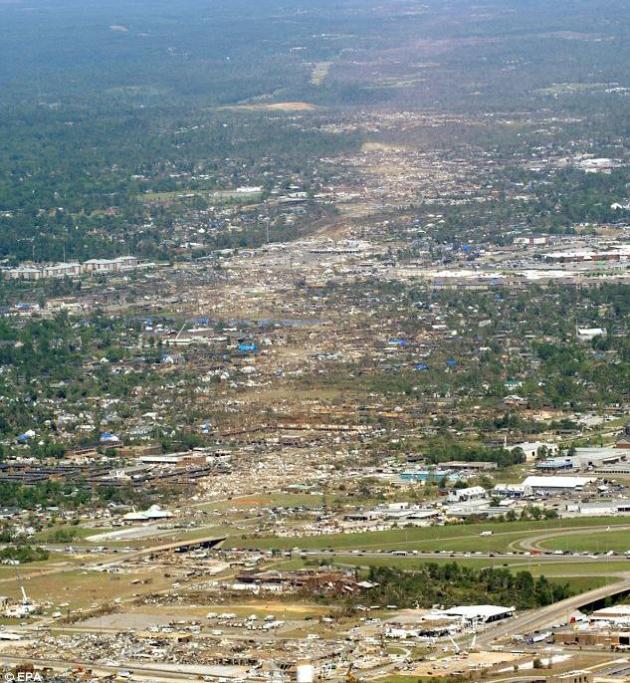
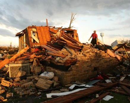
Insurers Rattled By U.S. Storms In 2011: Beyond Tornado Alley. Bloomberg Businessweek has the story; here's an excerpt: "Insurers are being forced to re- think their models after tornadoes killed more than 550 people in the U.S. this year, data provider CoreLogic Inc. said. More than 1,550 confirmed tornadoes had been reported in the U.S. as of Dec. 1, making it the third-most-active season since 1980, according to a report today from Santa Ana, California-based CoreLogic. The death toll from the storms was about the same as the number of fatalities from U.S. tornadoes in the prior 10 years combined, the report showed. “In the past, companies were confident they had an accurate underwriting knowledge of the areas, such as ‘tornado alley,’ that resulted in the greatest claims,” CoreLogic said in the report. “During the past few years, however, property, casualty and commercial insurers have begun to realize they need to carefully re-evaluate this perception.”
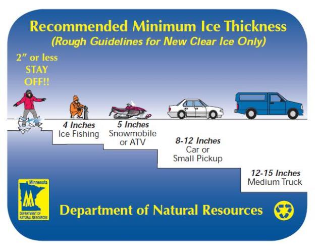
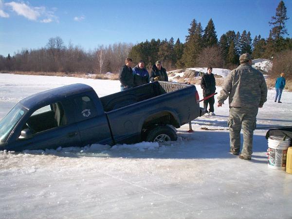
Ice Safety. With the unusually mild December underway be VERY careful on area lakes. You need 3-4" of (firm) ice to safely walk or ice fish, 5" for snowmobiling, 8-12" to take your vehicle onto the lake. More from the Minnesota DNR:
1). Many ice drownings involve children. When your child is near the ice, you should be near your child.
2). Avoid alcoholic beverages when you’re on the ice. They can make you feel colder and slow down your reaction time in case of an ice emergency.
3). Carry two large nails to use as ice picks to pull yourself out if you fall through thin ice.
4). Never drive on the ice at night.
5). Avoid pressure ridges, and areas with current if you do choose to drive on the ice.
6). Drive with your windows down and doors partially open to avoid becoming trapped if your car breaks through.
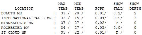
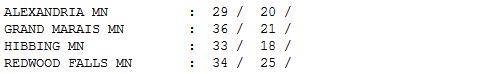
Cooling Down. Breaking news: nearly 1" of snow engulfed/swamped/invaded International Falls Thursday - a whopping 3" on the ground. Highs were mostly in the 30s during the wee hours of the morning, falling through the 20s by afternoon as north winds gusted over 30 mph. By evening it definitely felt like mid December again.
Paul's Conservation Minnesota Outlook for the Twin Cities and all of Minnesota:
TODAY: Patchy clouds, few flakes possible - feels like mid December again. Winds: SW 3-8. High: 28
FRIDAY NIGHT: Partly cloudy. Low: 17
SATURDAY: Partly sunny, a bit milder. High: 31
SUNDAY: Mild sun, feels like mid November. Low: 21. High: near 40
MONDAY: Slightly cooler, still storm-free. Low: 23. High: 30
TUESDAY: Storm tracks well south/east of Minnesota. Some sun. Low: 18. High: 31
WEDNESDAY: Sunny and milder. Low: 22. High: 35
THURSDAY: Cooler breeze. Good travel weather. Low: 24. High: 31
A Touch Of Winter
Everywhere I go people are glaring at me (more than usual). "Where's the snow, Paul? I want to go snowmobiling - how far do I have to drive?" Pack a lunch and head for the U.P. of Michigan. Really. "When can we play pond hockey - when will ice be safe enough?" Temperatures run 5-10 degrees above average through Christmas, daytime highs above freezing much of next week. Be VERY careful on the ice until we get a couple weeks of sustained, bitter air - which may not happen until January. I still don't see any arctic air for Minnesota - in fact long-range guidance (GFS) is hinting at 40 on New Year's Day. That's 40 above.
I realize it's disorienting, all this brown. It feels like December in Tulsa. A few silver linings: based on heating degree data we've saved 18% heating our homes and businesses since September. Cities are saving millions on snow removal.
Last winter may have been a fluke, an aberration. The trend is toward shrinking winters, warmer nights, fewer subzero smacks, and fickle, unreliable snowfall.
Stray flakes today give way to weekend warming; 40 possible by Sunday. No big storms looking out 2 weeks. Yes, it's a bit surreal, and more than a little unsettling.
"Climate change is likely to be the predominant scientific, economic, political and moral issue of the 21st century. The fate of humanity and nature may depend upon early recognition and understanding of humanmade effects on Earth’s climate."- recent report from Makiko Sato and James Hansen

Senator Franken's Colloquy with Senator Whitehouse On Climate Change. Climate Science Watch has a YouTube video of the presentation made by both senators on the floor of Congress on Wednesday: "On December 14 Sen. Al Franken (D-Minnesota) and Sen. Sheldon Whitehouse (D-Rhode Island) took to the Senate floor and the C-Span airwaves to talk about climate change, the scientific evidence for anthropogenic global warming, the problem of the global warming disinformation campaign, and the need for strong US action. These days we too rarely see progressive, pro-science members of Congress speak up to counter the denialist noise machine of Sen. Inhofe and his ilk."
* a pdf transcript of their presentation from the Congressional Record is here.
NASA: Warming Will Transform Natural World. The story from the Orange County Register: "Global warming could bring a major transformation for Earth's plants and animals over the next century, a NASA study says, driving nearly half the planet's forests, grasslands and other vegetation toward conversion into radically different types of ecosystems. The ecological stress could give a boost to invasive species, but at the expense of natives, reducing the diversity of plants and animals overall. And humans are likely, almost literally, to cut them off at the pass: When plants and animals attempt to survive by shifting their geographical ranges, as they have in past episodes of climate change, they'll be blocked by farms and cities."
No comments:
Post a Comment