**MIDDAY SATURDAY UPDATE**
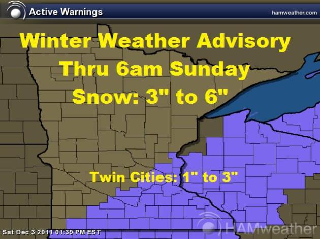
**WINTER WEATHER ADVISORY NOW CONTINUES UNTIL 6AM SUNDAY**
SNOW: Within the advisory area, 3" to 6" of snow is possible - HOWEVER, the Twin Cities is likely to see 1" to 3" with the higher amounts on the southeast side of town and lighter amounts on the northwest side of town. Anywhere from 3" to 6" (some isolated +6") can be expected from Mason City, IA to Albert Lea, MN to Rochester, MN to Winona, MN to Eau Claire, WI
**MIDDAY RADAR**
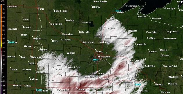
The radar as of midday shows that the atmosphere is starting to saturate, with some light snow already starting to fall across southern MN. Accumulating snow is still on track for the southeastern side of the state with around 1" to 3" still expected across the Twin Cities (heaviest on the southeast side of the city)
SATURDAY: Shovelable/plowable snowfall event begins by midday, mainly across southeast Minnesota. The Twin Cities looks to get clipped with some light stuff, could be worth of some light shoveling/brushing in the southeast Metro, by the evening hours. High: 34 Winds: SW turning NW 5-15mph.
SATURDAY NIGHT: Heaviest snow potential is from the afternoon hours of Saturday through the evening hours of Saturday. Total accumulations across the Twin Cities: 1" to 3" (heavier amounts on the southeast side of the metro and the lighter amounts on the northwest side of the metro). Low: 23. Winds: NNW 5-15mph
SUNDAY: Lingering flurries possible very early, otherwise a sunnier start with a cloudier afternoon/evening as another clipper drops south of the International border. Could see some light snow/flurries late. High: 31 Winds: WNW 5-10mph
MONDAY: Breezy, feels like December! Few scattered light snow showers possible early. Low: 16. High: 22 Winds: N 10-20mph
TUESDAY: Cold sunshine, brisk wind chill. Low: 8. High: 19. Winds: SW 10-20mph
WEDNESDAY: Still cold, increasing PM clouds. Low: 12. High: 25
THURSDAY: Cold with some sun. Low: 13. High:19
FRIDAY: Still cold with a few passing clouds. Low: 8. High: 18
DON'T FORGET TO SEND SNOW REPORTS & PICTURES TO ME, I'LL USE THEM IN THE BLOGS LATER TODAY/TOMORROW:
tnelson@weathernation.net
More updates to come,
Todd Nelson
No comments:
Post a Comment