45 F. high in the Twin Cities Thursday. We missed a record high by 2 degrees.
24 F. average high for January 5.
25 F. high temperature reported at MSP on January 5, 2011.
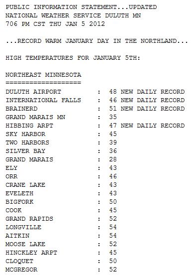
Thursday Record Highs:
43 F. at Eau Claire, Wisconsin Thursday, breaking the old record of 41 in 1930.
46 F. at International Falls yesterday, a new record for the date.
48 F. in Duluth yesterday, breaking the old record of 40, set in 1984.
51 F. at Brainerd yesterday.
52 F. in Mankato, breaking the old record of 45 set in 1958.
55 F. at Alexandria Thursday, breaking the old record of 38 in 1984. I can't remember the last time I saw a record broken by 17 degrees.
59 F. at Redwood Falls, breaking the old record of 47 in 1958.
63 F. at Marshall and Canby Thursday afternoon, more than
40 degrees above average for January 5.
63 F. Aberdeen, South Dakota. That's 41 degrees above average, a new state record for January.
* 115 record highs set Thursday around the USA. Source: NBC News.
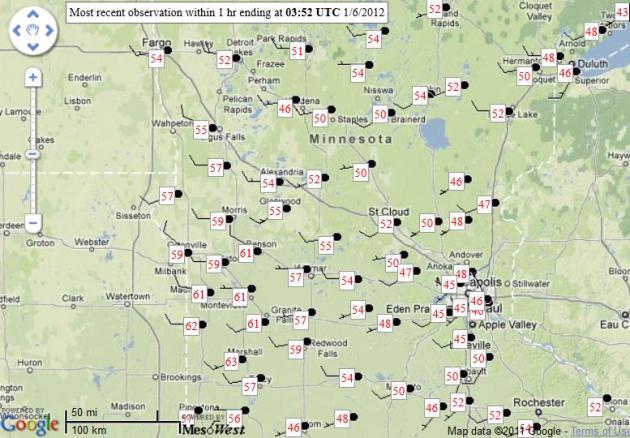 Thursday Highs
. What month is this again? Just glancing at the high temperature map above you'd swear it was mid April. 50s and 60s across much of central, western and southern Minnesota? During what is (allegedly) the coldest time of the entire year? Amazing, bordering on surreal.
72 F. Thursday afternoon in Sterling, Colorado.
70 F. at the same time in Tucson, Arizona.
60s in Minnesota...in January? I've been here 26 winters and I can't honestly recall seeing 60s during the first week of January. A period of mid and high-level clouds around midday kept the immediate metro a few degrees cooler than we would have been otherwise. Had the sun been out over the lunch hour we probably would have hit 50 or beyond. Just when you think you've seen everything...
8 hours, 55 minutes of daylight today in the Twin Cities.
9 minutes of additional daylight since December 21.
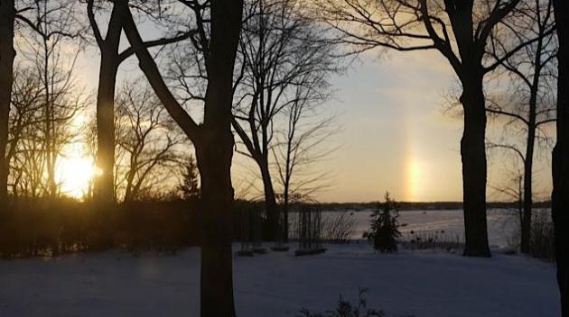
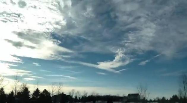
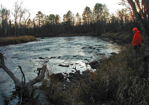
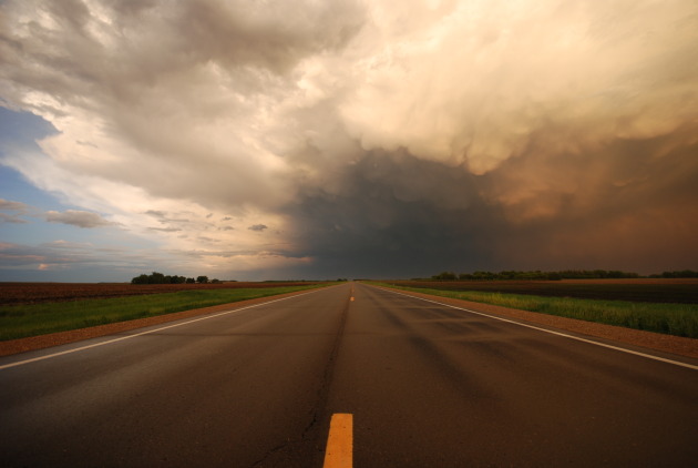
A March-Like Sky. Thanks to WeatherNation meteorologist Rob Koch for this great
time-lapse, taken from his home (on an iPad2) in the north metro Thursday.
Aberdeen SD – Thursday’s Record high (46) already exceeded and will be SMASHED (63). Will also be warmest temperature EVER recorded in January (records go back to 1893).
Sidney NE – Yesterday’s record high (62) already exceeded (currently 74). All-TIME January high of 74 is tied, and may be exceeded in the next couple hours.
Records already tied/exceeded Thursday in:
Sioux Falls, Rapid City, Watertown, Pierre, Mobridge, and Sisseton, SD
Sioux City, Ottumwa, Mason City, and Lamoni, IA
Rochester, Duluth, and International Falls, MN
Madison, WI
Omaha, and Lincoln, NE
* Thanks to Julie Gaddy at Earth Networks for passing on these records.
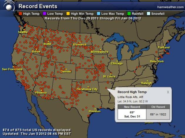
One Week's Worth Of Record Highs. I can't remember ever seeing anything like this, certainly not during the first week of January. 875 record highs since December 29 from coast to coast, most west of the Mississippi. Map courtesy of NOAA and
Ham Weather.
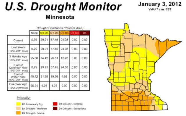
57.45% of Minnesota in a moderate or severe drought. The last time this much of the state was in a moderate drought was 2007. Source:
MN State Climate Office. The latest Drought Monitor map for Minnesota (Jan. 3) is
here.
47.7 F. average temperature in the Twin Cities for the entire year of 2011.
46.3 F. average temperature from 1981-2010.
+1.4 F. temperature departure for 2011 at KMSP.
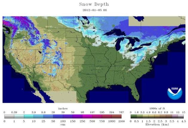
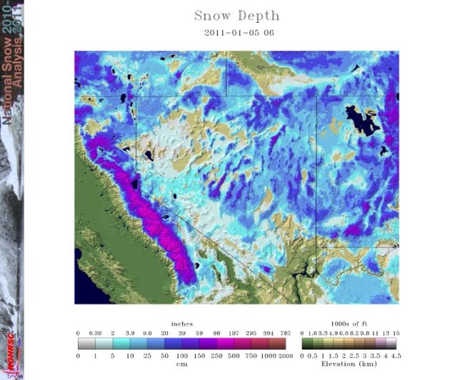
U.S. Snow Drought Could Have Serious Implications. Here's a timely article from
Scientific American: "
The snow drought across the U.S. so far this winter has raised questions about impacts on water supply, ski resorts and agriculture. Only 22 percent of the nation was covered by snow on Jan. 4, 2012. A snow depth analysis on Jan. 4 from 2004-2012 reveals the smallest area of the U.S. is covered by snow this year. The year 2007 ranks as the second smallest area of the U.S. with snowcover of about 27 percent. The Intermountain West, especially the Sierra of California and the mountains of Nevada and Utah, shows a substantial snow drought this year when compared to normal and past years. The northern Plains and the upper Great Lakes are other areas that have little snowcover compared to past years." The latest USA snowcover map is
here, courtesy of NOAA.
"
In some families, please is described as the magic word. In our house, however, it was sorry." - Margaret Laurence. Photo credit
here.
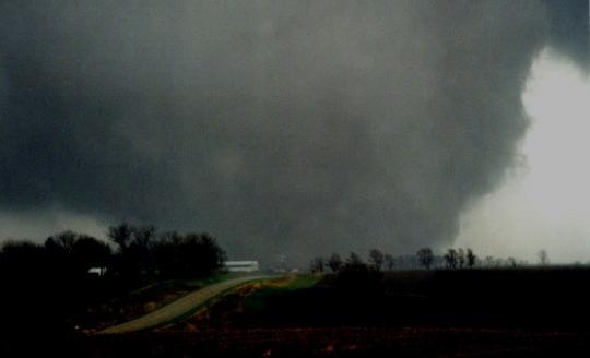
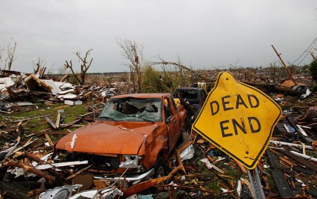
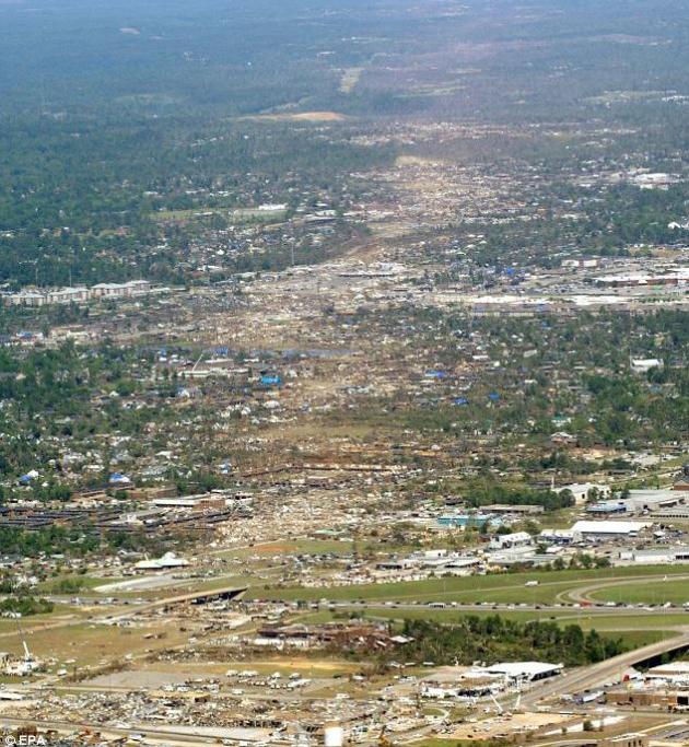
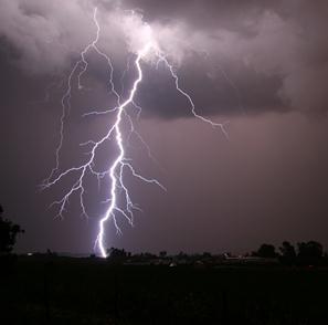
552 tornado-related deaths in the USA in 2011, most since 1925. This, in spite of Dopple radar, vastly improved warning technology and live TV/radio updates.
Year Of The Tornado. "
Carl Hedde of Munich RE America described 2011 as the Year of the Tornado. U.S. statistics show that the 552 twister-related fatalities made tornados the deadliest since 1925. There were 158 deaths associated with the Joplin, Mo., twister alone. April spawned 748 tornadoes — 226 of them on just one day. Six thunderstorm events associated with twisters chalked up losses exceeding $1 billion each and the late April tornadoes in Alabama and May twister in Joplin together racked up $6 billion in damage catapulting these events into the top 10 costliest natural catastrophes in U.S. history." - from an article at Science News below.
Troubling Trends. "
In contrast, he noted, what hasn’t maintained a constant pace over time have been the numbers of storms, droughts and wildfires. These weather and climate-related events have been climbing steadily since 1980, increasing in number, severity (such as average wind intensity) and often in lives lost. That trend, Rauch said, provides strong evidence that climate change is already impacting human suffering and the world’s economies." - from sciencenews.org; story below.
2011. A Year To Forget. From a post at the
National Wildlife Federation: "
And just in case you may think 2011 was an aberration, the report suggests that this is part of a trend that is consistent with the scientific predictions of mounting extreme events finding that:
- Average annual winter storm losses have almost doubled since the early 1980s.
- Average thunderstorm losses have increased fivefold since 1980."
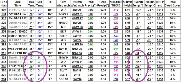
Colder, But No Subzero Air In Sight. The 16-day GFS model output shows significant colder air returning to Minnesota between January 19-21, highs in the teens, lows dipping into single digits. But I still don't see any subzero low temperatures, at least for the immediate metro, through the 3rd week of January. We have yet to see negative numbers in the Twin Cities.
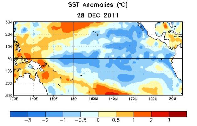
La Nina Expected To Continue Into Northern Spring 2012. NOAA's CPC,
Climate Prediction Center, has the latest: "
During December 2011, below-average sea surface temperatures (SST) associated with La Niña continued across the eastern and central equatorial Pacific Ocean (Fig. 1). The weekly SST index in the Niño-3.4 region remained near –1.0°C throughout the month (Fig. 2), indicating a weak to moderate La Niña. The oceanic heat content (average temperature in the upper 300m of the ocean) anomalies strengthened across the eastern Pacific (Fig. 3), reflecting a large area of below-average temperatures in the subsurface (Fig. 4). In the atmosphere, anomalous low-level easterly and upper-level westerly winds strengthened over the central and west-central Pacific. Convection remained suppressed in the western and central Pacific and enhanced over northern Australia and parts of Indonesia and the Philippine Islands (Fig. 5). Consistent with these conditions, the Southern Oscillation Index (SOI) also strengthened. This evolution is consistent with past events, in which the atmospheric components of La Niña become strongest and most well-defined during the Northern Hemisphere winter. Collectively, the ongoing oceanic and atmospheric patterns reflect the continuation of a weak to moderate La Niña."
Snow Drought Out West. From @JustinNOAA: "
Only 4% of Great Basin region has snow compared to 83% last year."
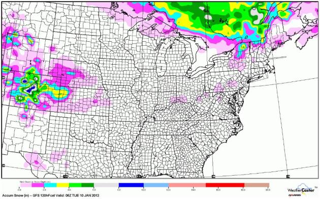
Expected Snowfall Through Next Monday Night. Any significant accumulating snow passes well north of the U.S. border through early next week (along the leading edge of arctic air). Some snow will accumulate in the mountains west of Denver - otherwise the pattern is remarkably quiet for early January. GFS model output courtesy of WeatherCaster.
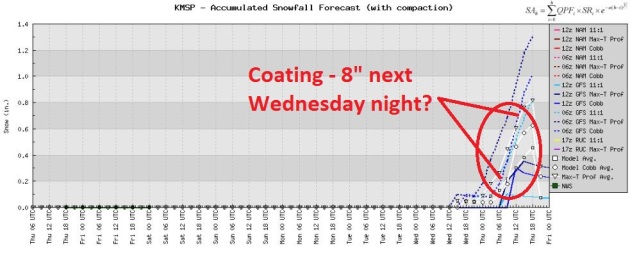
Winter (Still) On Hold. The first chance of a (nuisance) snowfall will come next Wednesday night and Thursday morning, as seasonably cold air bubbles south of the Canadian border. Highs will be in the 20s one week from now, closer to average for this time of year.
"
There is often less danger in the things we fear than the things we desire." - John C. Collins
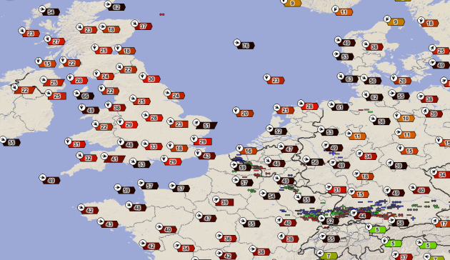
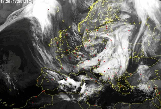
Wild And Windy. Here's a weather map showing sustained winds (red) and wind gusts (in black) for the U.K. and much of northern Europe. Winds gusted over 60 mph across much of the region, downing trees and powerlines, creating a fair amount of meteorological havoc. Map courtesy of James West at Earth Networks.
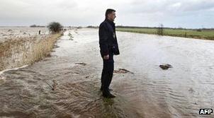
Storm, Flooding Prompt Dutch Evacuation. The story from the
BBC: "
Dutch villagers have been asked to leave their homes and farms because strong winds and heavy rain have led to fears of coastal flooding. Some farmers in Tolbert in the northern province of Groningen refused to leave their cattle, despite reports that an inland dyke was at risk of breaking. There are flood warnings for the Dutch west coast. Gales have also battered the UK, Belgium, France and Germany. Winds of up to 178kmh (111mph) were recorded in northern England."
Dutch On Flood Watch As Storms Hit Flights, Shipping, Farmland. Bloomberg's
Businessweek.com has the story: "
The Dutch authorities are taking measures to prevent flooding across the country amid storms that have delayed flights, disrupted shipping at Rotterdam and led to evacuations of cattle and livestock. Most flights at Amsterdam’s Schiphol airport are being delayed and some have been canceled as high winds limit the number of available runways, according to the airport website. Some ships have been unable to enter or leave Rotterdam, Europe’s biggest port. People and cattle are being evacuated in the northern province of Groningen after heavy rain raised water levels in the canals that crisscross the low-lying country." Image above courtesy of
sat24.com.
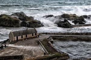
Hurricane-Strength Winds Cause Havoc As Storms Lash Ireland Again. The story from
irishcentral.com: "
Near record hurricane force winds are continuing to batter Ireland, with forecasters warning of more gales to come. Emergency services have been on high alert across the country as the high winds took their toll, with heavy rain now also present in many locations. Flights and ferry sailing have been cancelled, roads have been blocked by fallen trees and thousands of homes have been left without electricity."
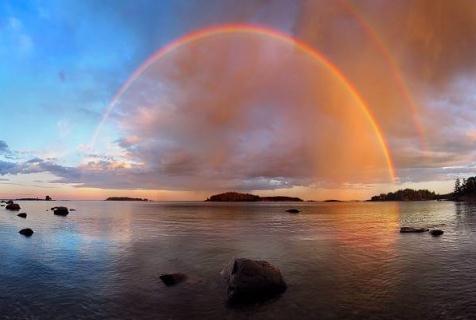
Photo credit above: "
Storm hits Northern Ireland Causeway Coast at Antrim. Photo by Press Eye."
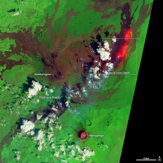
Fresh Lava Flow In Africa. NASA's
Earth Observatory has the interesting details: “
After bursting to life with 300-meter (1,000-foot) tall lava fountains in November 2011, the eruption of central Africa’s Nyamuragira Volcano continued into the new year. “
A Year In Technology. Gizmag.com reviews some of the most amazing new technology of 2011: "
We cast a wide net over all types of new and emerging technologies here at Gizmag.com - some save us time, some keep us connected, some help us stay healthy and some are just plain fun, but at the core of what we cover are those discoveries and innovations which have the potential to impact the fortunes of the human race as a whole and make a difference to the future of our planet. So with the calender having rolled over into another year, it's an ideal time to take a look back at some of the most significant and far-reaching breakthroughs that we saw during 2011."
More iPad3 Rumors: HD FaceTime Camera, iPad2 Priced At $399. Here's more from
businessinsider.com: "More reports and rumors about the
iPad 3 are squeaking out as we get closer to that
rumored February launch date. The latest rumors come from
iLounge's Jeremy Horowitz, who just
unleashed a series of tweets with iPad 3 details he heard from a source. Here's what the tweets say:
- The front FaceTime camera will be HD. The rear camera will be on par with the iPhone 4 or 4S camera. FaceTime calls will reportedly look a lot better.
- The iPad 3's body will be about 1 mm thicker than the iPad 2 to make room for new advanced parts.
"
Go with your heart, buddy. Our brains only screw things up." - Chris Fedak and Allison Adler, "Chuck Versus The Ring."
Paul's Conservation Minnesota Outlook for the Twin Cities and all of Minnesota:
TODAY: Partly sunny, still March-like. Winds: W 10-15. High: 42
FRIDAY NIGHT: Partly cloudy, still warmer than average. Low: 26
SATURDAY: Mix of clouds and sun, cooler. High: 37
SUNDAY: Intervals of sun, too quiet for early January. Low: 19. High: 33
MONDAY: Plenty of sun, warming up again. Low: 22. High: near 40
TUESDAY: Too early for spring fever? Dry sky. Low: 26. High: 42
WEDNESDAY: Colder and cloudier; flurries north. Low: 22. High: 29
THURSDAY: Flurries taper, clouds linger. Closer to "average". Low: 14. High: 22
A Deepening Drought
Love it or hate it, the (alleged) Winter of 2011-2012 is raising eyebrows. According to NOAA less than 21% of America is covered in snow, compared with 48% one year ago. Talk about a humbling turn of events. A few months ago, based on La Nina, meteorologists were predicting "colder and snowier than average" for the northern tier states, including Minnesota. I went out on a limb by predicting a drier winter, but, like everyone else, I've been blown away by the persistence of a mild, Pacific breeze. 50s and 60s? Talk about a super-sized January Thaw!
The upside? Fewer traffic accidents - cities are saving millions on snow removal - we've saved 20% on our heating bills so far this winter. The downside: Minnesota's snow economy is suffering and the drought is getting worse.
According to Greg Spoden at the MN State Climate Office 57.45% of the state of Minnesota is in a moderate drought; the most widespread dry rut since 2007. If this spills over into spring the implications for farming will be significant. With any luck the pattern will shift, upper level steering winds will become southwesterly, allowing moisture from the Gulf of Mexico to surge north, fueling more significant storms. That said, my gut (nausea?) is that the drought may get worse before conditions hopefully improve later this year. We'll see.
We should hit 40 today, again Monday and Tuesday of next week. Colder weather arrives late next week, but nothing arctic is brewing. I still don't see any subzero temperatures. Amazing.
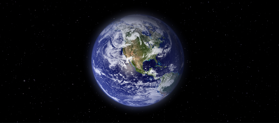
The 2011 Climate B.S.* Of The Year Award. Climate scientist Peter Gleick has the honors at
forbes.com: "
The Earth’s climate continued to change during 2011 – a year in which unprecedented combinations of extreme weather events killed people and damaged property around the world. The scientific evidence for the accelerating human influence on climate further strengthened, as it has for decades now. Yet on the policy front, once again, national leaders did little to stem the growing emissions of greenhouse gases or to help societies prepare for increasingly severe consequences of climate changes, including rising temperatures, changing rainfall patterns, rising sea-levels, loss of snowpack and glaciers, disappearance of Arctic sea ice, and much more. Why the failure to act? In part because climate change is a truly difficult challenge. But in part because of a concerted, well-funded, and aggressive anti-science campaign by climate change deniers and contrarians. These are mostly groups focused on protecting narrow financial interests, ideologues fearful of any government regulation, or scientific contrarians who cling to outdated, long-refuted interpretations of science."
Climate Change Costs U.S. Big Time. Here's an informative post from the
National Wildlife Federation:
Extreme Wildfires
- 2011 was the worst wildfire year on record in Texas due to persistent drought.
- In spring 2011, over 3 million acres burned in west Texas from 12 major fires with over 200 homes and businesses destroyed, $50 million insured loss.
- In September 2011, the Bastrop County Complex Fire near San Antonio destroyed over 1,600 homes causing insured losses of $530 million.
Extreme Mississippi River Flooding
- In 2011, heavy snowmelt, saturated soils, and over 20 inches of rain in a month lead to the worst flooding of the lower Mississippi River since 1927.
- Record river crests at Vicksburg and Natchez; Morganza Spillway opened in Louisiana to protect Baton Rouge and New Orleans from possible levee failures.
- The flooding caused extensive agricultural damage, property, and inland marine losses. The estimated economic losses are $2 billion and insured losses of $500 million.
National Association Of Evangelicals on Global Warming: "Care, Understand, and Respond." Here's a post from J. Drake Hamilton at
fresh-energy.com: "
More and more Christians believe that concern for climate change is inferred by their faith, since it is a natural outgrowth of caring for the environment and the world’s poor. Excerpted below is part of an excellent new discussion paper, “Loving the Least of These: Addressing a Changing Climate,” thoughtfully prepared by Christians working with the National Association of Evangelicals. God calls for us to care for those who are poor, vulnerable and oppressed. It is the Christian thing to do. While others debate the science and politics of climate change, my thoughts go to poor people who are neither scientists nor politicians. They will never study carbon dioxide in the air or acidification of the ocean. But they will suffer from dry wells in the Sahel of Africa and floods along the coasts of Bangladesh. Their crops will fail while our supermarkets are full. They will suffer while we study."
The Climate Message Is Not Being Heard. Here's How To Change Tack. The U.K.
Guardian has the story: "
Over the past decade, as news on the looming threat from global warming has continued unabated and become increasingly dire, public opinion has stayed static or become more indifferent to the need to take drastic action. In 2011 the UK weathered the second warmest autumn on record in more than a century, while land surface temperatures were the seventh warmest on record across the globe. Even the mild-mannered David Attenborough could not conclude Frozen Planet without warning of the dangers of global warming. But who was listening? Most polls paint a worrying picture for scientists, environmentalists and activists: that attitudes have not just remained static over the past decade but in some cases actually worsened. Increasingly, these groups are left preaching to the converted rather than winning the battle for public opinion."
 Carbon Dioxide Super-Scrubber? Potential Good News In Global Warming Fight
. The
Christian Science Monitor has the story: "
Using cheap, readily available materials, a team of chemists has developed a new compound for drawing carbon dioxide out of the atmosphere. The compound holds the potential to drive down the cost of capturing carbon, although it's too early to say by how much, the scientists say. The results "add to the list of possible materials that can absorb CO2 from the air, and it potentially could be quite a good one," says Klaus Lackner, who heads the department of earth and environmental engineering at Columbia University in New York and was not part of the team formulating the material."
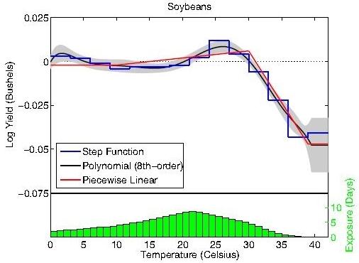
Climate Change And The Trillion-Dollar Disruption. Here's an excerpt of an article at
forbes.com: "
They also took a stab at projecting yield reductions a century from now, and built their projections on the most optimistic and pessimistic warming scenarios. Under the most optimistic scenario, yields dropped between 30% and 46% by the end of the century; while under the most pessimistic projection, they dropped between 63% and 82%. The prospect of an 82% drop in yields on the world’s staple crops is too frightening to even contemplate (it really is! Think about it.), but at the American Geophysical Union’s (AGU) fall meeting in December, 2011, Chris Field cited the Schlenker/Roberts study while examining two issues less likely to spark our collective denial reflex: uncertainty and non-linearity."
Insurance Payouts Point To Climate Change. An update from
sciencenews.org: "
Natural disasters in 2011 exerted the costliest toll in history — a whopping $380 billion worth of losses from earthquakes, floods, tornadoes, hurricanes, wildfires, tsunamis and more. Only a third of those costs were covered by insurance. And the tally ignores completely any expenses associated with sickness or injuries triggered by the disasters. The single priciest events last year were the magnitude 9 earthquake and tsunami in Japan, which wrought some $210 billion worth of devastation, followed in second place by the series of earthquakes in New Zealand that triggered $16 billion worth of destruction, notes Ernst Rauch of Munich Reinsurance corporate headquarters in Munich."


No comments:
Post a Comment