16F. high in the Twin Cities Tuesday. Afternoon high.
23 F. average high for January 17.
25 F. high temperature a year ago, on January 17, 2011.
1/10th of an inch of snow fell Tuesday. Ugh.
Trace of snow on the ground.
11.3" snow so far this winter season.
53.9" had fallen on the metro as of January 17, 2011.
December 3: last time the Twin Cities saw a "plowable" snow (4.2")
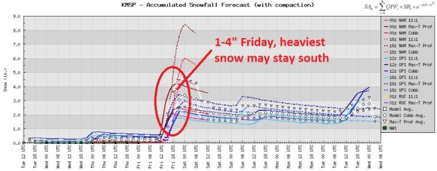
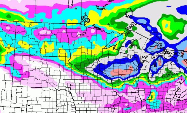
1-3" snow possible Friday (NAM and GFS models). The ECMWF model keeps most of the snow south of MSP Friday.
Little snow on the ground at MSP will prevent the mercury from falling as much as if we had significant snowcover. In fact nighttime lows (with little or no snow) may be 5-10 degrees milder than they would with 6" snow on the ground.
 Least Winter Snowfall In The Cities?
17.4"
Least Winter Snowfall In The Cities?
17.4" 1986-1987
17.5" 1967-1968
19.1" 1958-1959
25.5" 2004-2005
*11.3" 2011-2012 (to date)
** photo courtesy of the Star Tribune.
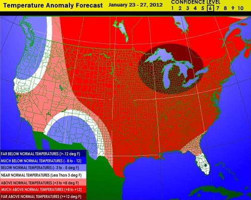
ECMWF European weather model predicts high temperatures in the Twin Cities at or above freezing every day from Sunday through Thursday of next week, as mild as 37-40 F. next Monday.
"
This is an emergency, we will shortly be making an emergency landing on water." - erroneous announcement made on a recent Miami to London British Airways flight. It was a computer malfunction - the plane made it to London with no problems, but passengers were VERY upset. Details below.
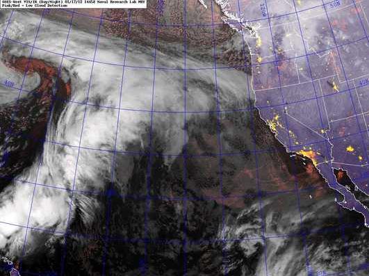
1985. The storm moving into the Pacific Northwest may produce the most snow since a blizzard in November, 1985. Satellite image courtesy of
NexSat.
Worst Seattle Snow Since '85 In The Forecast.
MSNBC.com has the latest on what may turn into an historic storm for Seattle and the Pacific Northwest: "
A major winter storm that could dump three times Seattle's annual snowfall on the city over two days was headed for the Pacific Northwest on Tuesday night and into Wednesday..... "Keep in mind, average annual snowfall is only 2.4 inches in Portland and 5.9 inches in Seattle, so these amounts are very significant for these metro areas."
Sledding On Roof: Alaska Buried Under Mounds Of Snow. The story from the AP and the
Seattle Times: "
ANCHORAGE — The most intense winter anyone in Alaska can remember has piled snow so high that windows are blocked, fuel has been delayed, roofs have been turned into sled runs and boats have sunk. While snow depths are below normal in most of the nation, Alaska is buried. More than twice as much snow as usual has fallen on the state's largest city, National Guard troops are digging out a fishing community and snow shovels are at a premium."
Photo credit above: "
A 14 year old boy clears the roof of his Anchorage home. More snow fell Thursday." Loren Holmes/AP."
"
I never had a policy; I have just tried to do my very best each and every day." - Abraham Lincoln
Another Chance....To Be Disappointed? My expectations have been dramatically lowered this winter. I keep reminding people (and myself) that we're in a drought. Getting significant snow is like swimming upstream (in molasses). We'll probably see some snow on Friday, but the ECMWF (European) model keeps the heaviest snow bands over southern Minnesota, closer to the Iowa border. That said, this is probably the best chance (of 1-3") we'll see looking out the next 1-2 weeks.
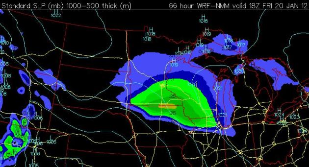
Friday Flakes? Somehow we seem to always miss out on accumulating snow, unlike last winter, when it wouldn't STOP snowing. The 00z NAM brings a super-sized clipper into central and southern Minnesota Friday, the map above valid midday Friday. The ECMWF (European) model takes the heaviest snow bands south of MSP - the heaviest accumulations may come from Mankato and Rochester into central Wisconsin. I have my doubts, yes, but the last 4 runs have been fairly consistent bringing some accumulating snow into the southern third of Minnesota. MSP may (once again) be on the boundary of "plowable" snow.
Bufkit Numbers. Based on a snow/rain ratio ranging fro 7:1 to 15:1 Bufkit is printing out 3" snow by Friday evening. I'm skeptical....but a little bit hopeful too.
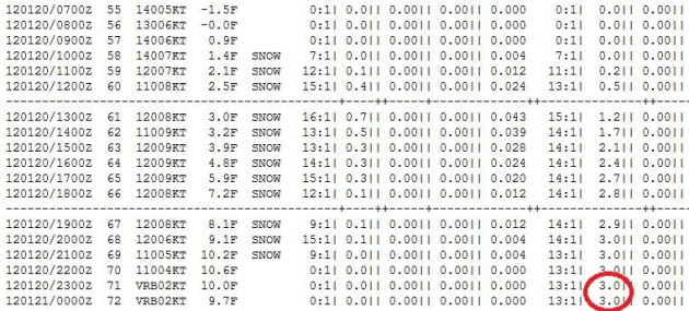
Brushed By Significant Snow? The latest NAM solution is showing some 6" amounts for the metro by midnight, Friday night. Again, I think these numbers are wildly inflated (they have been most of the winter). I was hesitant to even include this in the blog, but in the spirit of full disclosure. Either way, the heaviest amounts are predicted for central Wisconsin, from near Black River Falls to Appleton and Green Bay.
Will We Tie...or Break The Record For Latest Subzero Low In The Twin Cities? If we (somehow) avoided negative numbers last night we'll set a new record for the latest (first) subzero in the metro. The old record is January 18, 2002. More from the
local NWS office: "
The likelihood of witnessing a below zero temperature across southern Minnesota and west central Wisconsin during any given winter is very good indeed. There has NEVER been a winter where temperatures failed to drop below zero. In the Twin Cities the least number of below zero days was 2 back in the winter of 2001-2002. As of January 16th, the temperature has not dropped below zero at Minneapolis/St. Paul International Airport this winter. January 18 is the latest date during the winter season that the Twin Cities has experienced its first below zero temperature, back in 1889. In addition, Mankato has yet to see a temperature below zero this winter as of January 16th. The least number of below zero days for a given winter in Mankato was 6, back in the wtiner of 1982-83. St. Cloud, Albert Lea and Eau Claire have already seen below zero days this winter. As of January 16th St. Cloud, Eau Claire and Albert Lea have all dropped below zero 2 times."
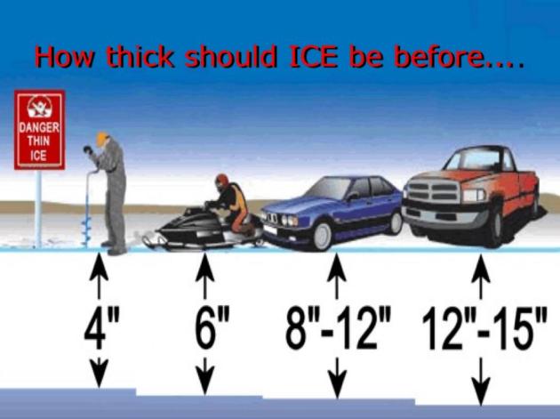
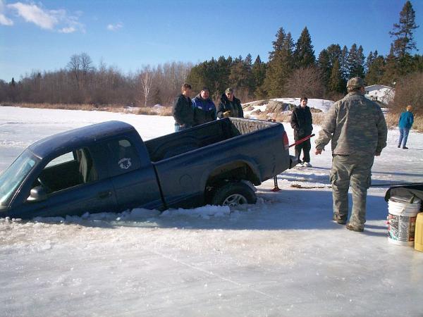
Ice Getting Thicker - But Still Not Totally Stable. With temperatures consistently below freezing this week ice conditions should improve over time, but another thaw next week may set us back a few notches again next week. Check with locals before venturing out onto any ice in the coming days.
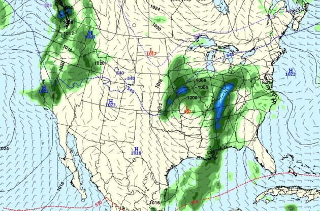
Another Near-Miss Early Next Week. This really sums up our snow-no-show-winter. Next week's storm will
probably pass south/east of Minnesota, a few outer bands of light snow may brush portions of southern and eastern Minnesota - a better chance of accumulating snow over Wisconsin. The truth: it's too early to tell with any confidence. We're in a drought. Best to keep your (snowy) expectations low.
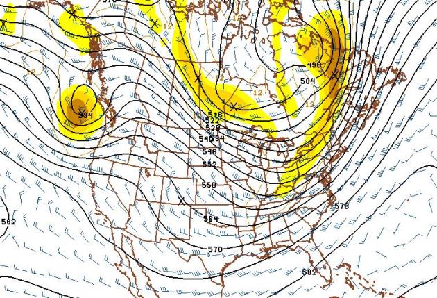
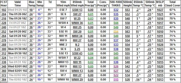
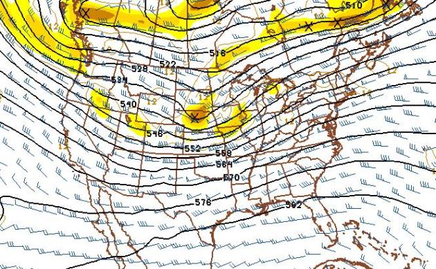
Seasonably Cold Start To February? Temperatures should trend considerably milder than average throughthis upcoming Sunday through the last week of January, but long range guidance is hinting at another close encounter (of the subzero kind) the first few days of February. 500mb map above (GFS forecast) valid February 2, courtesy of NOAA.
Ill-Timed Thaw. The GFS has been trending too cold for much of the winter - the physics in the model assumes it's mid January, when, in fact, the atmosphere has been blowing in an almost March-like pattern. If 850mb (3,500 foot) temperatures really do hit +11 C Saturday, January 28, we could see surface temperatures in the low to mid 40s. Either way the models are trending warmer with each passing run for the last week of January, followed by a turn to seasonably colder weather in early February. Oh, it goes without saying...no big storms in sight from Jan. 25 to Feb. 2.
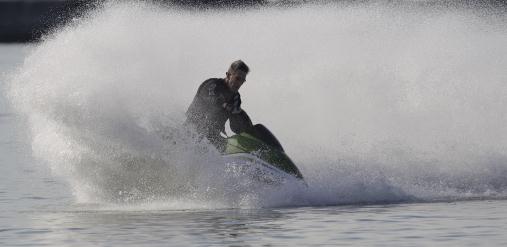
Water Sports In Mid January? Amazing but true: "
Bob Hens rides on his personal watercraft in Lake Erie during the warm winter weather in Buffalo, N.Y., Wednesday, Jan. 11, 2012. His friend, Tim Koester, not shown, but who was riding with him, said they would normally be riding their snowmobiles at this time of year. (AP Photo/David Duprey)."
Balmy Winter Brings Plenty Of Economic Surprises. AP and
timesfreepress.com have the story: "
NEW YORK — Out of a relatively balmy winter have sprung some economic surprises. People have more cash in their pockets because they aren’t turning up the thermostat. Airlines don’t have to de-ice planes or battle blizzards. And shoppers are finding great deals on coats and boots. But there are also disappointments. Merchants are stuck with unsold shovels and snow blowers. Drugstores say customers aren’t buying cold medicine or getting as many flu shots. The weather has been so mild that at some hardware outlets, rakes are flying off the shelf, and grass seed is outselling ice-melting salt. “I haven’t seen this mix of sales since I can remember,” said David Ziegler, whose family owns nine Ace Hardware stores in the northwest Chicago area. “They’re buying rakes ... just because it’s warmer and people are not holed up.”
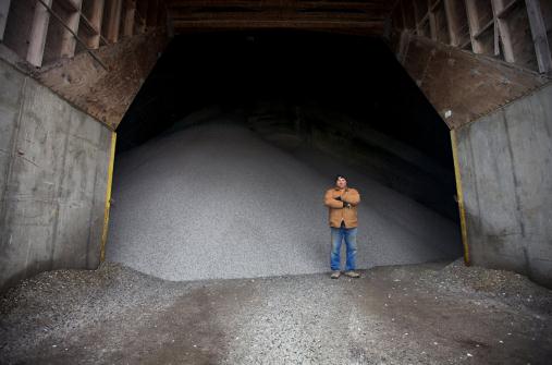
Photo credit above: "
Jeff Gould, lead equipment operator for the Department of Public Works in Sioux Falls, S.D., stands in front of a giant salt dome filled with rock salt Wednesday, Jan. 11, 2012. Gould says the pile would be half size by this time of a normal winter. Wednesday marked just the fourth time of this winter season that the city was hit with even a light covering of snow. The warm winter has put more green in the pockets of state and local governments that had their budgets busted last year by the high cost of plowing and running roaring furnaces. (AP Photo/Amber Hunt)."
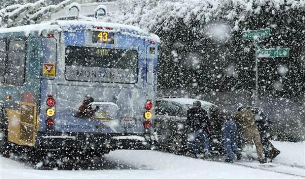
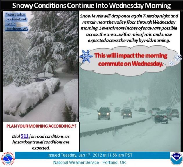
So THIS Is What Snow Looks Like. Here's the latest from the National Weather Service in Portland, Oregon, courtesy of
Facebook: "
Snowy conditions continue into Wednesday morning. Snow levels will drop once again Tuesday night and remain near the valley floor through Wednesday morning. Expect a variety of snow accumulations, ranging from a trace to several inches, with a mix of rain and snow in the valley by mid morning. This will impact the morning commute on Wednesday. Plan your morning accordingly! Also, remember to dial 511 for road conditions, as hazardous travel conditions are expected."
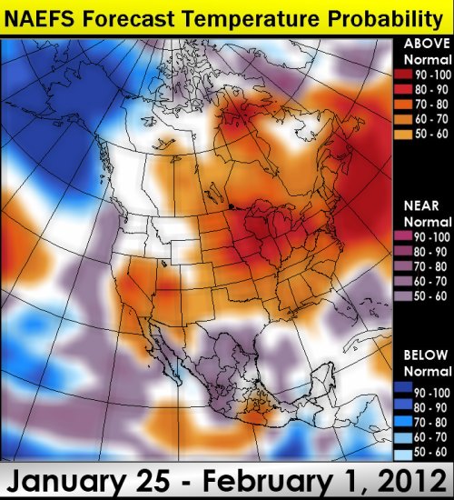
Unseasonably Mild Again Next Week? Meteorologist and long-range weather forecasting guru Larry Cosgrove, based in Houston, is predicting (much) warmer than average weather next week east of the Rockies as a westerly, Pacific flow resumes.
Warming Trend. The NAEFS super-ensemble shows a strong tendency toward milder-than-average weather for much of America the last week of July. Map courtesy of Larry Cosgrove and WxAmerica.
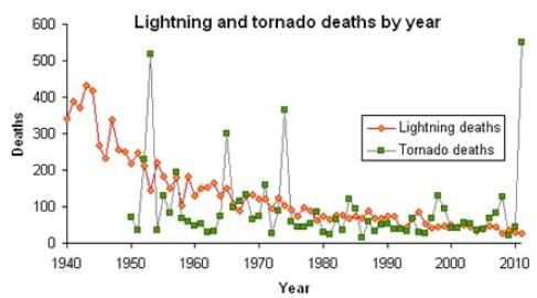
Record Low For Lightning Deaths In 2011 But Tornado Deaths Third Highest; Why The Disparity? Jason Samenow from the Washington Post's
Capital Weather Gang has an interesting story: "
Out of the all the bad weather news in 2011, one notable success story emerges: lightning deaths were lowest in the 71-years of record keeping. Just 26 people were killed by lightning in 2011, which is amazing considering the frequency of violent severe weather outbreaks across the U.S. By comparison, 551 people were killed by tornadoes in 2011, the most since 1950 and third highest on record according to NOAA. The striking difference between lightning and tornado fatalities begs the question why..." Graph above courtesy of NOAA.
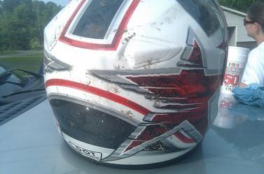
Alabama Tornadoes: Helmets Provide Inexpensive Protection, UAB Researchers Say. An intriguing story from the
Birmingham News: "
BIRMINGHAM -- UAB researchers say that motorcycle helmets, football helmets and bicycle helmets offer a practical, inexpensive solution to reducing the risk of head injuries during a tornado and are calling on the federal Centers for Disease Control to incorporate the advice in its tornado preparedness messages. "It's such a common sense idea that we wonder why it hasn't caught on," said Scott Crawford, an epidemiologist and one of authors of "Safety Helmets: A Practical Inexpensive Solution for Reducing the Risk of Head Injuries Resulting from Tornadoes."
Photo credit above: "
Mike Culberson credits this helmet with preventing injury, if not saving his life, when his home roof collapsed during tornado in Fultondale, Ala., on April 27, 2011. (Special/Michael Culberson)."
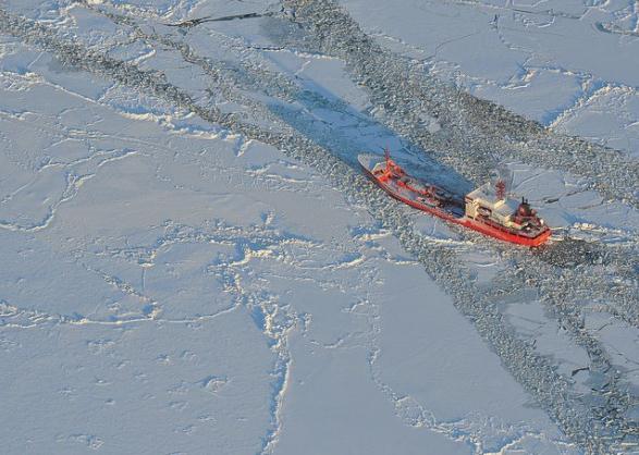
Fuel Tanker Finally Reaches Iced-In Alaskan Town. The
Great Energy Challenge blog from National Geographic has the latest: "
The Russian tanker Renda, loaded with 1.3 million gallons of fuel, finally made it to Nome over the weekend, ending a journey that began in mid-December and involved breaking through more than 300 miles of ice. It followed a path plotted and sheared out by the U.S. Coast Guard’s currently only operating Arctic icebreaker, the Cutter Healy. Nome is in the southern Seward Peninsula coast on Norton Sound of the Bering Sea (map). The region was originally used as a hunting ground by the Inupiat settlement of Sitnasuak, but the population grew due to the discovery of gold in the late 1800s and the region’s use as an airstrip in World War II. In 2010, according to the U.S. Census, the city population was 3,598."
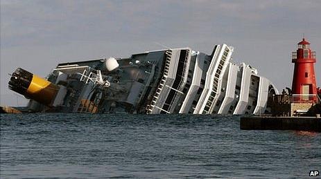
A Timely Question: How Safe Are Cruise Ships? The
BBC has some answers: "
Effectively, the company has 24 hours to take you through a drill once you are on board. The Costa Concordia was only a few hours into its voyage. Some people arriving back at Heathrow started flashing their drill cards around. They had been scheduled for a rehearsal on Saturday afternoon, by which time the ship was lying on its side. I suspect, in the light of this accident, all cruise companies will now make sure they drill passengers before they set sail. But what about the time it took to get everyone off? Regulation III/21.1.3: All survival craft required to provide for abandonment by the total number of persons on board shall be capable of being launched with their full complement of persons and equipment within a period of 30 min from the time the abandon ship signal is given after all persons have been assembled, with life jackets donned."
British Airways Crew Mistakenly Announce That Jet Is Going Down. Talk about the definition of a bad flight - being told you have a few minutes until a "water landing", which is probably a death sentence high over the North Atlantic?
CNN reports: "
British Airways cabin crew sparked panic by mistakenly activating an emergency announcement that said the plane was going down, and passengers should brace for a water landing. The message on the Miami-London flight reportedly said: "This is an emergency, we will shortly be making an emergency landing on water." A flight attendant came on the public address system about 30 seconds later to apologize, saying the message was played by mistake, according to the Daily Mail. A spokesman for the airline confirmed the incident and said: "The cabin crew canceled the announcement immediately and sought to reassure customers that the flight was operating normally."
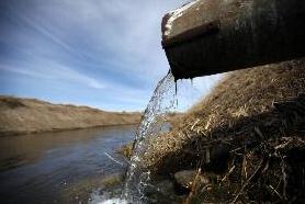
Minnesota Launches Minnesota River Cleanup Effort. The Star Tribune has the details: "
Minnesota will be the nation's first test site for a federal program designed to stem the flow of agricultural pollution strangling some of the country's great bodies of water, including Chesapeake Bay, the Gulf of Mexico and the Mississippi River. Gov. Mark Dayton is expected to announce Minnesota's leading role in the project at the Capitol on Tuesday morning, with Tom Vilsack, U.S. secretary of agriculture, and Lisa Jackson, administrator of the U.S. Environmental Protection Agency, at his side."
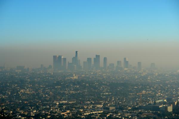
EPA: Job Killer Or People Saver? CNN analyst LZ Granderson reminds us that a Republican, Richard Nixon, kicked off the EPA. Is clean air and water a civil right? Here's an excerpt of his Op-Ed: "
The way some Republicans talk about the Environmental Protection Agency, you would think it was created by a bunch of pot-smoking hippies communing at a nudist camp in northern California -- when in fact, the EPA was created by one of their own, Richard Nixon, in 1970. Much as Republicans don't like to bring up the huge tax increases instituted by their hero, Ronald Reagan, they prefer to sidestep their role in the EPA's humble beginnings and blame it on Democrats. They characterize the whole thing as an albatross hanging around the economy's neck. To be fair, Nixon did not ride into the White House as a conservationist, and he did veto the Clean Water Act. But he said he did so because of the price tag of the policy, not its purpose. After the Santa Barbara oil spill in 1969 -- which at the time was the largest in U.S. history -- Nixon agreed with the rest of thinking society that clean water and air were a good thing. And his fingerprints are all over such tree-hugging initiatives as the Clean Air Act."
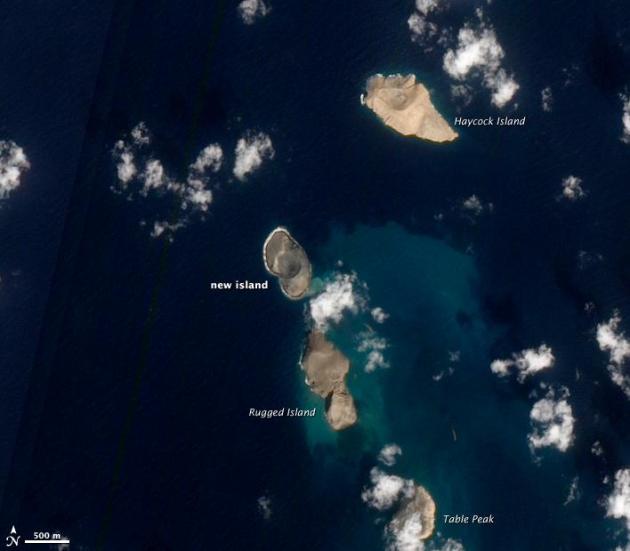
A Newborn Volcanic Island In The Red Sea. NASA's Earth Observatory has the story: "
A volcanic eruption in the Red Sea appears to have stopped, leaving behind a newborn island. The new island is part of the Zubair Islands, located about 60 kilometers (40 miles) off the coast of Yemen. The Advanced Land Imager (ALI) aboard the Earth Observing-1 (EO-1) satellite acquired this natural-color image on January 15, 2011."
“To carry a grudge is like being stung to death by one bee.” – William H. Walton
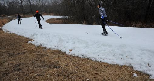
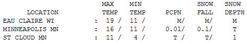
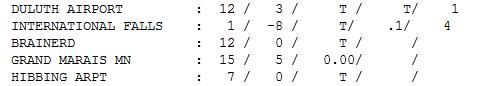
Feels Like Winter. A Canadian breeze rustled the trees yesterday, afternoon temperatures stuck in single digits and teens, in spite of a bright, pleading sun. Highs ranged from 1 above at International Falls to 11 St. Cloud, 16 in the Twin Cities and 19 at Eau Claire. Duluth only has 1" snow on the ground, a "trace" of snow in St. Cloud and MSP.
Paul's Conservation Minnesota Outlook for the Twin Cities and all of Minnesota:
TODAY: Some sun, warming up a bit ahead of clipper. Winds: S 10-20. High: 25
WEDNESDAY NIGHT: Light snow and flurries - coating possible; turning MUCH colder. Low: -4 (metro). As cold as -8 to -10 in some of the outlying suburbs.
THURSDAY: First widespread subzero morning. Bright sun - bitter. High: 4
FRIDAY: Potential for a couple inches (best chance southern Minnesota). Low: -3. High: 11
SATURDAY: Fading sun, a bit milder. Low: -4. High: 23
SUNDAY: Chance of snow (mainly over Wisconsin). Low: 10. High: 34
MONDAY: Partly sunny and quiet - milder than average. Low: 14. High: 37
TUESDAY: Storm may stay south/east of MN. Small chance of snow. Low: 19. high: 33
One Odd Winter
Every day is a new creation; every weather pattern is different and unique. That's liberating, and a little bit terrifying. We can have similar patterns, but never identical. Computers help, but they're only as good as the physics, the math we use to simulate how the atmosphere SHOULD behave. Junk in, junk out.
The reason for my rambling preamble? We're in uncharted waters. I can't remember a winter this...strange. Much of winter has been downright Marchlike; about a fifth as much snow as last winter. This lack of snowcover will keep temperatures about 5-10 degrees warmer than they would be otherwise in mid January. Subzero readings are still likely tomorrow, but we bottom out around -4, instead of -11, had we had a few inches of snow on the ground. Then again: can you feel any colder than numb?
Tough times for snow enthusiasts. Ski Seattle? The Pacific Northwest is getting buried under 1-2 FEET of snow, possibly the biggest snowstorm since 1985.
Next week's storm will probably sail south/east of Minnesota again. Our only chance of accumulating snow? Friday. The NAM prints out a few inches, but the European (ECMWF) model keeps snow south of MSP. It just doesn't want to snow this winter.
"
We should all be concerned abou the future because we will have to spend the rest of our lives there." - Charles F. Kettering. Photo credit
here.
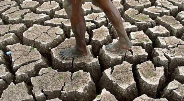
Climate Stories....
Climate Proposal Puts Practicality Ahead Of Sacrifice. The New York Times has the story (subscription may be required): "
After looking at hundreds of ways to control these pollutants, the researchers determined the 14 most effective measures for reducing climate change, like encouraging a switch to cleaner diesel engines and cookstoves, building more efficient kilns and coke ovens, capturing methane at landfills and oil wells, and reducing methane emissions from rice paddies by draining them more often. If these strategies became widespread, the researchers calculate, the amount of global warming in 2050 would be reduced by about one degree Fahrenheit, roughly a third of the warming projected if nothing is done. This impact on temperatures in 2050 would be significantly larger than the projected impact of the commonly proposed measures for reducing carbon dioxide emissions."
Newly Discovered Molecule Has Potential To Offset Climate Change And Cool Planet. The story from
gizmag.com: "
Researchers claim a newly discovered molecule found in the Earth's atmosphere holds the potential to help offset global warming by actually cooling the planet. The molecule is a Criegee biradical or Criegee intermediate, which are chemical intermediaries that are powerful oxidizers of pollutants produced by combustion, such as nitrogen dioxide and sulfur dioxide. They have the ability to naturally clean up the atmosphere by helping break down nitrogen dioxide and sulfur dioxide to form sulfate and nitrate, which ultimately leads to cloud formation that could help cool the planet."
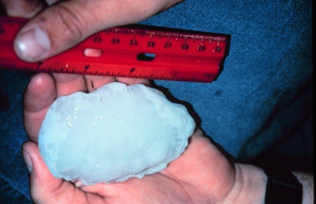
Study: Hail May Be Gone From Front Range By 2070. Denverpost.com has the story: "
Hail — and the physical and economic damage that comes with it — could be gone from Colorado's Front Range by 2070, say Boulder scientists. Not having hail to deal with would be a boon to gardeners and farmers. But a shift from hail to rain can also mean more runoff and a greater risk of flash flooding, said Kelly Mahoney, a research scientist at the University of Colorado's Cooperative Institute for Research in Environmental Sciences. "In this region of elevated terrain, hail may lessen the risk of flooding because it takes a while to melt," she said. "Decision-makers may not want to count on that in the future." Photo above courtesy of NOAA.
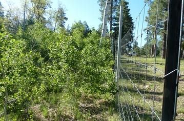
Climate Change Ripples Through Mountain Ecosystems.
LiveScience.com has the story: "
Like dominoes given one nudge, climate change in the form of reduced winter snowfall on mountaintops has subtle but powerful cascading effects felt throughout entire ecosystems, a new study finds. In the northern mountains of Arizona, elk spend their winters in lower elevations where there’s much less snow and the cold is less pronounced. But the decrease in high-elevation snowfall in the mountains over the last 25 years has allowed elk to forage in these areas throughout winter. Researchers found that the elks' year-round high-elevation browsing has decimated the density of seasonal woodsy plants, which, in turn, has impacted the populations of songbirds (animals you might expect would actually benefit from less snow)." Photo courtesy of USGS.
Why Are Some People (and interest groups) So Afraid Of Al Gore? I think some people just can't get past Al Gore's politics, and the fact that his (courageous) movie brought the subject of climate change into a very public light. They believe that if you accept that the climate is changing, and we're a big part of those changes, then somehow you have to buy into Al Gore and his politics. Really? That's one (big) negative for some of my conservative friends - they don't like Mr. Gore. But there's an even bigger issue: a majority of skeptics, deniers and contrarians don't want to accept reality and the facts on the ground because, if they do, then they have to swallow draconian solutions, like bigger government, more regulation, higher taxes. More rubbish. The
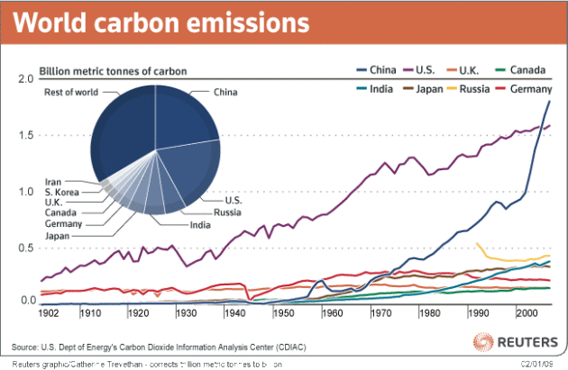
markets will eventually figure this out and unleash new, revolutionary carbon-neutral technologies, so we can have clean energy, without the unpleasant side effects. Government can set policy and provide (initial) incentives, but only the markets will be able to figure this out, in my humble opinion. But that doesn't mean we stick our heads in the (Saudi) sand until the problem goes away. Unfortunately, with China adding one new coal-fired plant every week, the problem isn't going away anytime soon. Graphic above courtesy of the Heartland Institute.
China Set To Launch First Caps On CO2 Emissions. China taking the lead in putting a cap on "carbon intensity"?
New Scientist has the story: "
Seven provinces and cities in China are to set caps on their greenhouse gas emissions, following a directive from central government. It's the first time the Chinese government has called for any absolute caps on emissions, having so far preferred softer "carbon intensity" targets. The move is a first step towards establishing carbon trading markets in China and further evidence of the country's commitment to tackling climate change, says Felix Preston of Chatham House, a foreign-policy think tank based in London. On 13 January China's National Development and Reform Commission asked the cities of Beijing, Tianjin, Shanghai, Chongqing and Shenzhen, and the provinces of Hubei and Guangdong, to set "overall emissions control targets". Photo courtesy of Reuters and
sinostand.com.
Climate Change, Can We Sue? New Climate Change Litigation Book Launched At COP17. The story from
Oxfam GB Policy and Practice: "
After the negotiations at Durban, a new book explores the role of litigation in bringing about climate justice. It remains to be seen exactly what the Durban Platform will mean in the long run, but with frustration mounting at the slow progress of negotiations despite growing evidence of adverse climate impacts, attention is turning towards alternative scenarios where the risk of litigation looms large. Whether as a liability claim (analogous to tobacco or asbestos litigation against business), or as an argument in a case about tort, planning or energy, climate change is finding its way into the courts in a wide range of countries. Until now the emphasis has been on litigation between states, or on domestic litigation in developed countries, but the picture is starting to get more interesting."


No comments:
Post a Comment