SUNDAY: Cloudy and warmer with light freezing drizzle possible early, turning to all snow late in the day. High: 32. Winds: SSE 5-15mph
SUNDAY NIGHT: Light snow possible, better chance of accumulations across central and northern Minnesota. Light accumulations of 1" or less expected in the Twin Cities. Turning windy and colder. Low: 20. Winds: WNW 10-20mph, gusts to 25mph
MONDAY: Light snow tapers to flurries, windy and cooler. High: 24. Winds: W 10-20mph, gusts to 25mph.
TUESDAY: Lighter winds and more sun. Low: 8. High: 22. Winds: WSW 5-10mph
WEDNESDAY: Increase in clouds, turning breezy with a few light snow or flurries.. Low: 14. High: 31. Winds: WSW 10-20mph
THURSDAY: Intervals of sun, another thaw. Low: 20. High: 30. Winds: S 10-15mph
FRIDAY: More sun, still mild. Low: 18. High: 31.
SATURDAY: Clouds thicken, still warmer than average. Low: 15. High: 28.
Hot Water @ 20 Below Zero
Thanks to Paul Sundberg for this neat shot. The recent cold snap had many folks either embracing or hating it. Paul apparently embraced it as he threw hot water into 20 below zero air temps, you can see how the water turned into steam and ice crystals... pretty neat!
Thanks for the picture Paul, great stuff!

Winter Weather Headlines For Parts of the State
The National Weather Service has issued a Winter Weather Advisory for parts of the state through Sunday for sleet and snow accumulations that could add up to 3" to 5" - note how the advisories are either way west or north of the Twin Cities. It is important to note that some of this could be mixed in with a little freezing drizzle as well.

Sunday's Wintry Mix
Take a look at the storm system below causing all the commotion. It's actually quite a messy looking storm, but from wintry weather on it's northern flank to storms and severe weather on it's southern flank, this storm will have lingering effects into the early work week.

Closer To Home
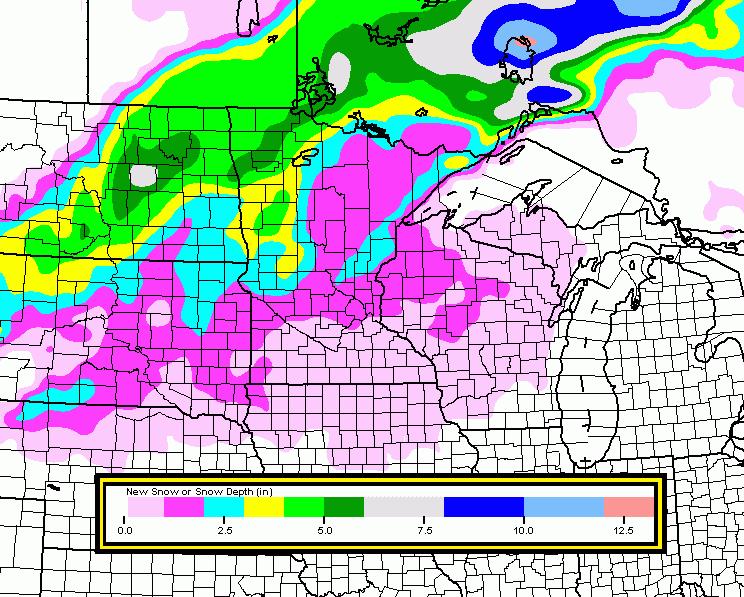
This is a look at the potential weather conditions we could have through 7pm Sunday. Keep in mind that the heaviest precipitation will occur through the eastern portions of North and South Dakota and through northern Minnesota, near where the Winter Weather Advisories have been issued.

Hardly Plowable For the Twin Cities
Forecast models have been pretty consistent on keeping the heaviest snowfall amount across northern Minnesota, where amounts could be enough to shovel or plow. Amounts across the Twin Cities don't look all that impressive and will likely stay in the nuisance category or perhaps maybe enough for a little light brushing or shoveling through early Monday.
National Severe Threat
This same storm system will bring a chance of severe weather to parts of the Ohio and Tennessee River Valleys late Sunday into early Monday. Hail, high winds and isolated tornadoes will be possible here. Strange to think that there could again be tornadoes in January for some of the same areas that were dealing with severe weather last week.

Heavier Rain Down South
The image below shows the precipitation forecast through Monday evening. Showers and thunderstorm could bring about an inch or more of rainfall to places that could see strong to severe storms into early Monday. Note also the higher amounts across the West Coast. These are places that continue to get pounded with Pacific Moisture. There have been a number of reports of several feet of snow piling up since last week and also reports of several inches of rain leading to flooding along the coastal locations. They're not quite out of the woods yet.

Sun Valley, ID After Fresh Snow
As the ski and snowboard hipsters say: "Look at all that fresh pow!"

Laurelwood, Oregon
Thanks to Mike Swaja for the picture below. Heavy rain falling in Oregon shows some of the flooding that has taken place.
Subaru powered volkswagen powering thru some high water (Near intersection of Springhill rd & Laurelwood rd. Laurelwood, Oregon)

Pond Hockey Championship
This is more my style! Lake Nokomis was buzzing with people this weekend for the Pond Hockey Championship. It was a very COLD start on Saturday, but the rest of the weekend was pretty mild considering how cold it was at the end of last week.
The picture below is from Twitter: @USPondHockey a good follow if you're aren't following already!

Saturday Was Hockey Day In Minnesota
One of my favorite days out of the entire year is #HockeyDayInMinnesota. Nearly 16 hours of hockey on FoxSportsNorth from high school to college to pro... sure to those who could give a hoot about hockey, it might sound a little excessive, but to those with strong hockey roots, it's almost as good as a holiday! Very touching, this year's hockey day in Minnesota was dedicated to Jack Jablonski.

Thanks for checking in and have a great rest of your weekend!
Don't forget to check me out on Twitter:
@TNelsonWNTV

Meteorologist Todd Nelson
No comments:
Post a Comment