23 F. average high on January 18.
19 F. high temperature a year ago, on January 18, 2011.
-34 F. this morning's record low at MSP (1970).
-25 F. wind chills this morning will dip into the -20 to -25 range in the metro, as cold as -40 over western Minnesota.
March 2, 2011: last time the mercury dipped below zero in the metro (-3 F.)
20s return by Sunday and Monday, highs close to 30 the latter half of next week. 40 F. is not out of the question by the last weekend of January, the 28th and 29th.
Coating - 1" snow possible Friday; maybe 2" far southern suburbs. Albert Lea, Winona and La Crosse may pick up as much as 2-4" of powdery snow. Travel conditions will worsen the farther south you drive, away from the metro, on Friday.
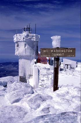
118 mph wind gust on the summit of Mt. Washington, New Hampshire Wednesday. Source: Weather Underground. Photo courtesy of the Mt. Washington Observatory.
46 states experienced weather-related catastrophes in 2011, according to The Red Cross.
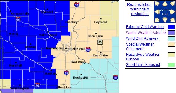
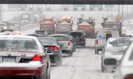
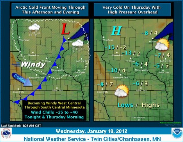
Extreme Cold Warning Until Noon. Welcome to what will probably wind up being the coldest day of winter. Morning wind chills dip to -25 in the metro, as cold as -40 over central and western Minnesota. More details from the local office of the National Weather Service: "An Extreme Cold Warning has been issued for areas northwest of a line from near Redwood Falls to Elk River to Cambridge. The dangerous wind chills will persiste through Thursday morning as overnight low temperatures dip to the 10 to 15 below range."
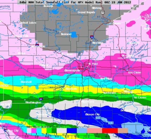
Friday: Another Near-Miss. It's amazing the number of ways we've missed out on snow this winter, the vast majority of storms detouring south/east of MSP. The latest NAM model prints out some 2-4" amounts over far southern Minnesota on Friday, maybe an inch in the metro, possibly 2" over far southern suburbs like Northfield and Credit River. The north metro may see little or no snow on Friday.

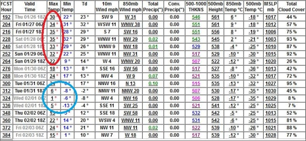
Mild End To January. The models are consistent: we should end January in the 30s, a 40 degree high not out of the question the last weekend of the month. The GFS is hinting at a (brief) chill around February 2, maybe 1 or 2 nights dipping below zero, before temperatures recover.
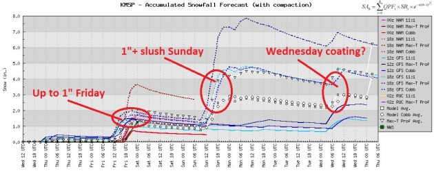
Dribs And Drabs Of Snow. We just can't buy a storm. I keep waiting for the pattern to shift. We're going to have to wait awhile longer. Up to 1" may fall from a fast-moving clipper Friday, another (slushy) inch possible Sunday (considerably more east of the metro into Wisconsin), another coating next Wednesday. Pretty exciting stuff, huh? At this rate we may wind up with a 30" winter. For the sake of farmers and anyone with a lawn or garden - I hope I'm wrong.
“It’s a silver lining on otherwise terrible events,” said Mark Steber, chief tax officer at Jackson Hewitt Tax Service. “Tax laws in many cases are very favorable,” he said."
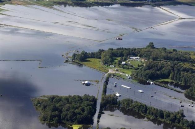
Photo credit above: "(Mel Evans, File/Associated Press) - FILE - In this Friday, Sept. 9, 2011 file photograph, buildings, fields and roads are flooded near Liberty, N.J., as remnants from Tropical Storm Lee continue to produce heavy rain. There were a record number of billion-dollar natural disasters in the United States in 2011, and taxpayers who suffered losses may be able to get some relief when they file their income tax returns."

1937 Flood Changed Louisville Forever. A fascinating story from courier-journal.com: "Seventy-five years ago in mid-January of 1937, intense rains drenched Louisville and continued falling for days. The Ohio River rose to levels never recorded before or since. The result was the “Great Flood of 1937” — one of the country’s worst natural disasters. For residents of the Louisville area, it was a “massive” life-changing experience, says historian Rick Bell of Crescent Hill. After it, people and industries began to flee flood-prone sites near the river to settle in what had been largely rural areas such as Shively, St. Matthews (which had been potato fields) and other communities."
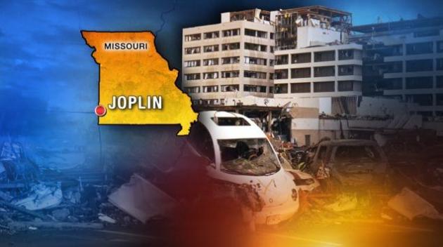
"Disaster Tourism" Stirring Up Controversy. A legitimate source of (new) revenue for a struggling, recovering town, or feeding off misery and downright tacky? Local10.com has the story:"

"Only your real friends will tell you when your face is dirty." - Sicilian Proverb

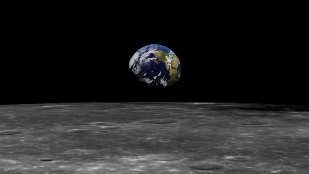
Apocalypse Not Now: NASA Debunks Doomsday Predictions. MSNBC.com has the encouraging news: "On Dec. 21, 2012, many doomsday believers fear the apocalypse — anything from a rogue planet smashing into us to our world spinning end over end. However, the world should expect nothing more next year than the winter solstice, the longest night of the year, NASA says. Many people point to the end of the Mayan Long Count calendar on Dec. 21, 2012 as evidence of the coming apocalypse, but astronomers have been quick to stress that there is nothing to be concerned about."
Photo credit: "Gilderm/sxc.hu".
Alaskan Dogsled Race Cancelled Due To "Impassable" Trail Conditions. While we suffer through a protracted snow drought, Alaska has more snow than it knows what to do with. The Fairbanks Daily News-Miner has the amazing details: "FAIRBANKS — The Copper Basin 300 sled dog race is the latest victim of Alaska’s weird winter weather pattern as race officials canceled the event Sunday morning, less than a day after the race started. The race came to a halt when a section of trail was deemed impassible. A statement by race marshal Greg Parvin said the trail between Meier’s Lake and Sourdough had unusually deep snow conditions, with high winds and bitter cold. Two Rivers musher Allen Moore, who was one of the race leaders, told his handlers that the trail got bad about 12 miles out of Meiers Lake and snowmachines were getting stuck in attempts to break a trail for the race." Photo above courtesy of alaska-in-pictures.com.
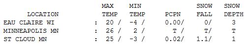


Nice To Be "Average". Ahead of the clipper a light south breeze tugged the mercury into the 20s over most of central and southern Minnesota, bitter air lurking just the north (a high of -5 at International Falls). Wednesday highs ranged from 11 at Hibbint to 25 St. Cloud, 26 in the Twin Cities to 29 at Redwood Falls. 1.1" snow fell at St. Cloud during a late afternoon snow burst ahead of the coldest air of winter.

TODAY: "Tundra-like" cold. Bright sun, possibly the coldest day of winter. Wind chill: -25 Winds: NW 10-15. High: 4
THURSDAY NIGHT: Clouds increase, still numb. Low: 0
FRIDAY: Light snow - Icy roads. 1-2" possible in the metro, 2-4" far southern MN. High: 10
SATURDAY: Better travel day. Fading sun, not as bitter. Low: -2. High: 17
SUNDAY: Milder, PM wet snow possible. Low: 11. High: 26
MONDAY: Drier day, more clouds than sun. Low: 14. High: 25
TUESDAY: Some sun, temperatures close to average. Low: 15. High: 23
WEDNESDAY: Chance of wet snow, still a few degrees milder than average. Low: 13. High: 27
Highs may climb close to 30 or even hit freezing by the end of next week.
Coldest Of Winter?
This is why we don't have a population of 10 million. Most Americans live in mortal fear of waking up to a morning like this. "So cold body parts start falling off, right"? Yep. That's why we have world-class health care. "Really?" Uh huh. Trust me. I'm a weatherman.
We've been through this drill before. Welcome to the 1st subzero morning of winter, and a record-breaking one at that. We set a record for the latest subzero on record in the metro. A stinging breeze will make it feel like -25 at the bus stop. Dress in layers - don't forget a hat. Keep those body parts intact. Only 2 days of pain. We'll get though this...
A peculiarly persistent Pacific wind flow aloft is responsible for our ongoing snow drought. Weather models have (consistently) overestimated snowfall amounts this winter. With that caveat I'm mentioning a potential for a whopping coating - 2" snow tomorrow; it may be enough to plow just south of MSP.
Temperatures blip upward over the weekend with 20s by Sunday (which will feel amazingly good). Long-range models bring the mercury close to freezing by the end of next week; another ill- timed January thaw. I fear Volcanis may get the last laugh at the St. Paul Winter Carnival next week.
My hunch: we're waking up to the coldest morning of winter, the "Relatively Easy Winter of '12".

Climate Stories....
Does Global Warming Mean More Winter Snow Storms. OBP News has a curious story: "While Northwest residents confront a winter snow blast, new research is pointing to climate change as a possible reason that harsh Arctic weather is pushing into some lower latitudes. The new study, published by Atmospheric and Environmental Research, is contradicting what current climate models tell us about winter weather patterns. It suggests warming trends in the spring, summer and fall are causing colder winters with more severe storms. The study’s lead author, Judah Cohen, says winter temperatures should be warming the most, according to climate models. But actual temperatures aren’t lining up with what those models have predicted."
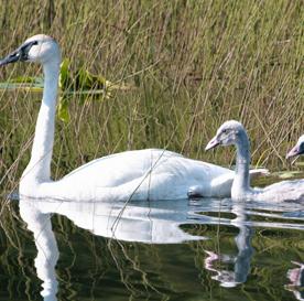
Trumpeter Swans Rebound, With An Assist From Global Warming. A silver lining? Bring it on. Scientific American has the story: "ANCHORAGE, Alaska - Outside Alaska's largest city, where wildlife is more common than pigeons, locals bearing field glasses turn out every year to watch blazingly white trumpeter swans stop to feed on their way south for the winter. The swans, famed for their French horn call and immortalized by author E.B. White, were nearly hunted to extinction in much of the United States and Canada by the late 1800s for their meat, feathers, down and quills. Now, North America's largest wild fowl may be one of the few good-news stories of global warming - at least for the short term." Photo: U.S. Fish and Wildlife Service.
In 2012 Let's Resolve To Fight Global Warming Together. The story from Huffington Post: "2011 was disastrous -- literally. Forty-six states in the U.S. alone experienced weather-related catastrophes, according to the American Red Cross. The National Oceanic and Atmospheric Administration (NOAA) recently reported that 2011 set a record for the number of U.S. disasters costing more than $1 billion each. Last year the 12 most costly U.S. disasters totaled approximately $52 billion and resulted in the loss of nearly 650 lives. Data from Munich Re indicate that the world economy experienced a record-breaking $265 billion in economic losses from disasters in just the first six months of 2011. These are just the consequences we can numerically count. The resulting human suffering is not quantifiable."
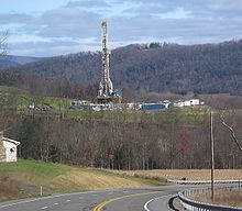
Marcellus Boom Threatens Climate Change Action, Study Says. The Charleson Gazette reports: "CHARLESTON, W.Va. -- The boom in drilling for natural gas in the Marcellus Shale and other similar formations will likely suppress the development of alternative energies that are urgently needed to combat global warming, according to a new study by researchers at the Massachusetts Institute for Technology. Researchers highlighted some positive aspects of the boom in drilling for "shale-gas" reserves, such as help in lowering gas prices and stimulating the economy. But they warned that a switch from coal to natural gas alone isn't nearly enough to reduce greenhouse gas emissions to the levels scientists believe are needed to curb the worst impacts of global warming."

Photo credit above: "Eugenie Scott (Image by Euthman via Flickr)."
Whats up very cool site!! Man .. Beautiful .. Wonderful .. I'll bookmark your site and take the feeds alsoกKI am glad to find numerous helpful info right here in the submit, we need work out more strategies in this regard, thanks for sharing. . . . . .
ReplyDeleteCompressed Tear Shaped Sponges - Multi Color 144 Pack