SATURDAY: Turning colder. Mostly cloudy with scattered flurries. High: 28. Winds: W 10-15 Gusts to 20mph
SATURDAY NIGHT: Cloudy and colder with scattered light snow showers, light coating. Low: 10. Winds: WNW 5-10mph
MONDAY: Lingering flurries possible early, then partly sunny and a little warmer. Low: 16. High: 36.
TUESDAY: Cloudy and mild with a light rain and snow mix possible. Low: 22. High: 36.
WEDNESDAY: Lingering clouds and flurries, still mild. Peeks of PM sun. Low: 24. High: 32.
THURSDAY: Cloudy, chance of light snow. Low: 21. High: 32
FRIDAY: Lingering light snow, cooler. Low: 21 High: 28
Friday's Weather in Photos
Friday was kind of a neat day weather-wise. I awoke to this faint sun pillar, which is visible just left of the church steeple. Sun pillars are shafts of light that reflect off of ice crystals in the atmosphere.

Snow Burst
Those clouds were on the leading edge of a weak disturbance that brought fairly heavy burst of snow through Minnesota around midday. It wasn't much and temperatures were warm enough to keep the light snow accumulations in wet & sloppy category rather than the fluffy and slippery category that we had earlier this week (AM Monday commute)
See video of the falling snow HERE:

Friday's Snow Reports
The Twin Cities didn't get all that much, up to 1", but there were reports of around 5" in northern MN!
Check out this snowfall total website HERE:

See video of the falling snow HERE:

Friday's Snow Reports
The Twin Cities didn't get all that much, up to 1", but there were reports of around 5" in northern MN!
Check out this snowfall total website HERE:

The St. Paul Winter Carnival continues this weekend with a more wintry scene than what we had through the early part of January. Record setting temperatures in the 50s and 60s had event planners and ice sculptors a littler worried. However, the Arctic blast that we had last week with single digit high temperatures and overnight lows dipping below zero 3 times (nearly 16 times below normal) and the few snow burps this last week, folks are breathing a little easier. If your weekend plans take you to St. Paul for any of the festivities, the weather won't disappoint. We'll continue that wintry feel with a little light snow developing later today and temperatures falling to more normal levels tomorrow, we've had much worse before.
A strong Pacific jet will jam several Pacific storms along Canada's west coast through the next several days. The relentless battering there will result in a somewhat active weather pattern for us as remnants of those systems wiggle through our neck of the woods. Nothing significant, but extended model runs hint at warm enough air for a rain and snow mix during Tuesday's system. On average, winter worst of the cold is over.
Surprise Asteroid's Near Miss with Earth
"Astronomers are saying that we shouldn't be concerned about 2012 BX34, the asteroid they were surprised to detect on Wednesday. After all, it's only passing by at less than a fifth of the distance to the moon, "one of the closest approaches ever recorded.""

First Lego Man in Space
" January 26, 2012 — It started out as a cool idea. Now, two teenagers from Toronto are garnering National attention after sending a Lego Man to the edge of the Earth's atmosphere."

Let's Stay in Space!
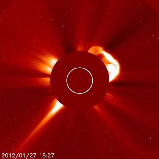
The sun continues to stay active as another solar storm occurred on Friday... It almost looks like a scorpion!
"Analysts at the Goddard Space Weather Lab say the cloud raced away from the sun at 2500 km/s or 5.6 million mph. The CME is not heading toward Earth, although it is too soon to rule out some kind of glancing blow on Jan. 28-29. Stay tuned for updates."


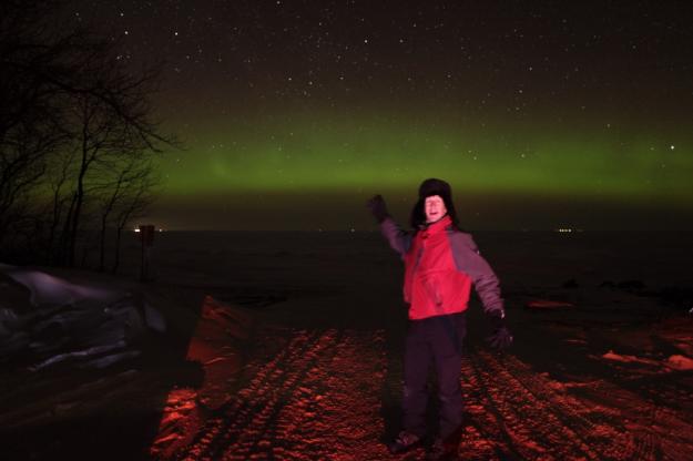
Northern Lights Pictures
These are incredible shots of some of the recent northern lights events that have taken place close to home.
Stephan Hogland - Grand Marais, MN
"They actually were quite vague but eh extreme dark of the forest an along exposure made for some great images canon 5d mkII 14 mm Tamron aspherical lens, 400 asa f4 200 second exposure"

Bob Conzemius - Lake of the Woods, MN
Great stuff Bob! Neat video too!!
I had to drive north a couple hours to get away from the clouds. I found a spot on the south shore of Lake of the Woods and took aurora photos for three hours! As I was heading south back home, the interplanetary magnetic field went south too, and the auroras brightened up a lot, so I put the camera in the back window of my car and let it take aurora photos while I drove.
Also see the video at http://youtu.be/fADU5djWSkw
Northern Lights Forecast Bookmark
This is neat and bookmark worthy. It's a forecast for the Aurora, which shows the intensity and possibility of viewing the current aurora!

Fairly Active Weather Ahead
The image below shows vorticity or spin in the atmosphere. Note the 'vort maxes' (I've highlighted them with a white 'X' - this shows areas of disturbed weather, where clouds and precipitation are more likely to occur. These 'vort maxes' are the result of a strong Pacific jet or a strong upper level wind slamming into the west coast of Canada. As the storm systems hit the west coast and the higher elevations of the Rockies, they tend to lose a lot of their moisture. As they descend down the lee side (east side) of the Rockies, they tend to dry out a bit, but we get the leftovers.

Weekend Precipitation
Note the heavy moisture along Canada's west coast, this is where most of the moisture is being deposited. As the fast moving storm systems (clipper systems) cross over the prairie lands of Canada and the Dakota, they leave a little strip of moisture, which will be snow, but not much. One of these little systems will slide through later Saturday and give us another shot of light snow and another light coating. Plus, on the backside of this Saturday system, temperatures will chill down and return to near normal levels on Sunday.

St. Paul Winter Carnival Continues
It's going to be a BIG weekend in St. Paul! The Winter Carnival continues and the Grand Parade is @2pm today. Check out the full list of events HERE:

Thanks for checking in and have a great weekend!
Don't forget to check me out on Twitter: @TNelsonWNTV

-Meteorologist Todd Nelson-
No comments:
Post a Comment