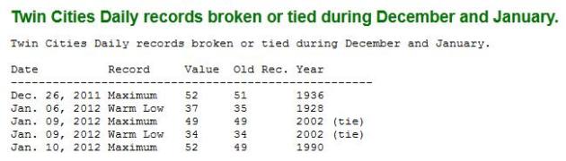
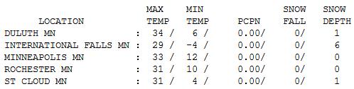
33 F. high temperature on Wednesday in the Twin Cities.
27 F. average high for February 8.
3 F. high temperature a year ago; February 8, 2011.
+12.3 F. The first week of February saw an average temperature just over 12 degrees F. warmer than normal.
2nd warmest. December 1 - February 7 was the second warmest such period in modern-day records, second only to 1877-78.
1877-1888. Commonly referred to as the "Year Without A Winter" across Minnesota. Details below.
 3,977
3,977 heating degree days since July 1. Source: MSP National Weather Office. That means a...
20% savings on heating bills since July.
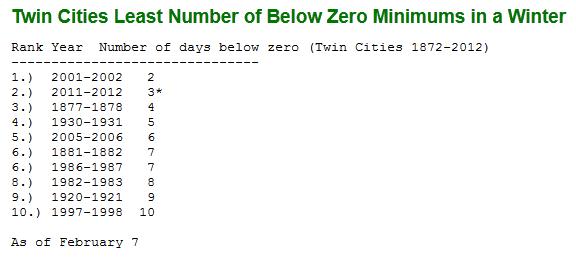
3 subzero nights so far this winter in the Twin Cities.
6.9 average number of subzero nights in February here in the metro area.
28 subzero nights during an average winter. Whatever that is.
 .06"
.06" least February precipitation on record in the Twin Cities (1964).
Trace of precipitation so far in February, 2012.
2nd warmest "meteorological winter". Data from December 1 - February 7. Source:
MN State Climate Office.
27 F. average temperature in the Twin Cities between December 1 and Feb. 7. That's 9.3 F. warmer than average. Only the Winter of 1877-1888 was warmer during that same period.
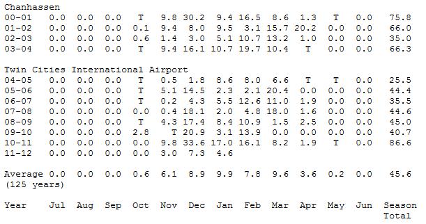
7 winters since 1986 with less than 40" snow in the Twin Cities. Details below.
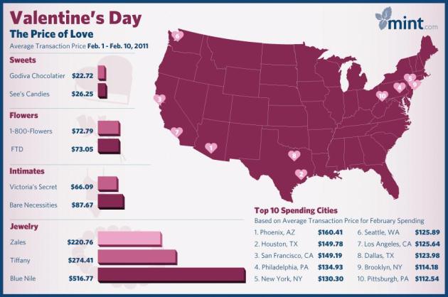
$73. Average amount of money spent on Valentine's Day flowers in 2011 nationwide. Source: mint.com. Photo: fdt.com.
$19 billion. Estimated savings from an unusually warm winter in 1998, linked to the strongest El Nino on record. More from the AMS (
American Meteorological Society): "
Benefits included an estimated saving of 850 lives because of the lack of bad winter weather. Areas of major economic benefits (primarily in the nation's northern sections) included major reductions in expenditures (and costs) for natural gas and heating oil, record seasonal sales of retail products and homes, lack of spring flood damages, record construction levels, and savings in highway-based and airline transportation."
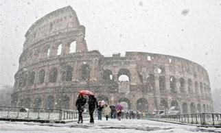
Europe Freezes.
"According to Bloomberg News, 93 stations from the Czech Hydrometeorological Institute reported the lowest-ever temperatures for February 5, with one station bottoming out near -38°F. In Ukraine, the cold has killed at least 131 people, and nearly 2,000 were hospitalized due to hypothermia. Ice has forced Austria to close the Danube river to navigation, shutting down access to part of the second-longest river in Europe. In addition, the iconic canals of Venice were reported to be frozen as well." - from a Climate Central article below on why Europe has seen extreme winter conditions, while North America is enjoying a March-like pattern.
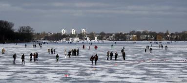
Photo credit above: "
People enjoy the frozen lake Alster in Hamburg, northern Germany, on Wednesday, Feb. 8, 2012. A cold spell has reached Europe with temperatures plummeting far below zero. (AP Photo/Matthias Schrader)."
22 States. "
A total of twenty-two states from Montana to Maine had December-January temperatures ranking among their ten warmest," NOAA reported. - from a Yahoo News article below.
"
Public opinion regarding climate change is likely to remain divided as long as the political elites send out conflicting messages on this issue." - from a Scientific American article below.
"
If we spew 565 gigatons more carbon into the atmosphere, we'll quite possibly go right past that reddest of red lines. But the oil companies, private and state-owned, have current reserves on the books equivalent to 2,795 gigatons – five times more than we can ever safely burn. It has to stay in the ground.....
Telling the truth about climate change would require pulling away the biggest punchbowl in history, right when the party is in full swing. That's why the fight is so pitched. That's why those of us battling for the future need to raise our game." - Bill McKibbon, in a story in The Guardian below.
"
Freedom has its life in the hearts, the actions, the spirit of men and so it must be daily earned and refreshed - else like a flower cut from its life-giving roots, it will wither and die." - Dwight D. Eisenhower
Fewest Subzero Nights In The Twin Cities? Pete Boulay at the State Climate Office forwarded me this
link, showing where we stand this winter in terms of average temperatures and number of subzero nights. I suspect we'll have at least one or two more nights of negative numbers before the sun angle gets too high for subzero weather, but that would still put us in the "Top 5" Winters for fewest subzero nights.
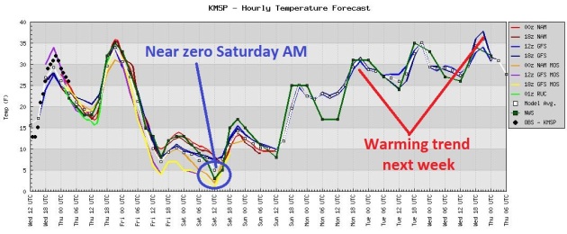
4th Subzero Night Of Winter? It'll be a close call - the urban heat island may keep immediate metro temperatures a few degrees warmer, but I expect the suburbs to wake up to a subzero start Saturday morning. It won't stay cold for long; temperatures quickly rebound into the upper 20s and low 30s next week. Yes, the worst of winter, a Tulsa-like winter at that, is behind us.
 Twin Cities Snowfall Since 2000
. The 125 year average at MSP is 45.6", the 30 year average is closer to 55" in the metro area. There have been 7 winters since 1986 with less than 40" snow in the Twin Cities. If history is any gauge, we SHOULD pick up another 16-17" snow by the end of April. Then again, this has been anything but an average winter. Data courtesy of
Minnesota State Climate Office.
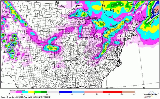
Expected Snowfall Through Midday Monday. The GFS prints out a little snow for Kansas City, but other than that it's pretty much lake-effect snow bands setting up downwind of the Great Lakes. I still don't see any significant chance of snow, ice or rain looking out through late February. Source: NOAA and WeatherCaster.
Farmers, More Than City Folk, Worried About Warm Winter. We've been in a drought since late summer, and it shows no signs of easing anytime soon, in fact it's the driest winter since 2007. Will this dry rut continue into spring planting season? I'm starting to think it will. Hope I'm wrong.
MSNBC.com has more: "
Illinois, a key farm state in the heart of the Corn Belt, is basking in its sixth warmest winter in 117 years -- good news for residents who have not had to shovel snow but a red flag for some of the state's most productive businesses: farms. Illinois and neighboring Iowa - also in the midst of a balmy winter - produce about a third of all the corn and soybeans grown in the United State, the world's largest exporter of both crops. Farmers in both states feel more comfortable when there is a substantial snow cover to ensure adequate soil moisture that can nurture crops through the region's hot dry summers. Illinois state climatologist Jim Angel said soil moisture, thanks to autumn rains, remained in good shape compared to pockets of drought in nearby areas of the Corn Belt, notably the high-yielding northern Iowa/southern Minnesota border area."
Photo caption above:
"Snow plows sit idle at a city of Chicago fleet garage on Dec. 29. Courtesy of M. Spencer Green/AP."
Mowing The Lawn...In February? "
Donald Thomas, maintenance supervisor at Park Plaza office complex in downtown Huntsville, Ala, mows the grass Tuesday Feb. 7, 2012, that has been growing during the warm winter in north Alabama this year. Thomas said it was very unusual for him to need to mow this time of year. (AP Photo/The Huntsville Times,Glenn Baeske)."
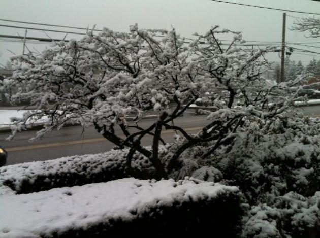
Candy-Coating Of Snow. Thanks to Joan Kruhoeffer, who works in Camp Hill, Pennsylvania. She sent in this photo of a sloppy 1/2" of snow in the suburbs of Harrisburg.
What's Causing The Deadly Cold In Europe? Andrew Freedman from
Climate Central has a good explanation of why the weather has been so brutally cold and snowy on the other side of the pond: "
While the U.S. cruises through winter with a snow drought and above-average temperatures, much of Europe and Eurasia are locked in the grips of a deadly cold air outbreak, with more than 300 people reported dead so far. According to news reports, entire communities in Italy, Bosnia, and Romania have become inaccessible due to heavy snowfall and power outages. According to Sky News, a dam in Bulgaria burst due to the combination of snowmelt and heavy rains, killing four people in a village downstream, and other dams in Southeastern Europe are also being threatened. Bosnia, Serbia, Macedonia and Turkey are at risk for heavy snows during the next few days."
5 Records So Far This Winter. Data courtesy of the
Minnesota State Climate Office.
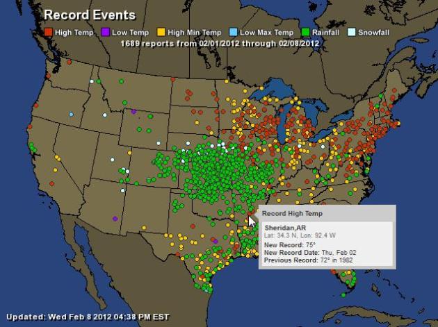
A Week's Worth Of Weather Records. A total of 1,689 records in just the last 7 days, according to NOAA and
Ham Weather. You can see evidence of last week's rain and snow storm from Denver into the central Plains. Note the number of record highs (red dots) and record warm nighttime mins (yellow dots) from the Upper Midwest into New England.
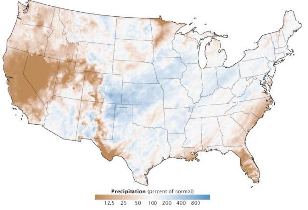
Why Was December So Warm And Dry? For that matter, why has the entire winter trended so warm and dry across so much of America? NASA's
Earth Observatory has more data: "
December 2011 was one of the driest Decembers on record in the continental United States—particularly short on snowfall—and also among the warmest. Several large-scale weather and climate patterns are likely to blame for an unusual jet stream and the unseasonal weather. The top map shows December precipitation across the lower 48 United States as a percentage of normal for the month. The map is based on measurements compiled by the NOAA Advanced Hydrologic Prediction Service. Shades of brown show rain and snow levels below normal, with blues indicating above-average precipitation. Much of the Pacific Coast, the Rockies, and Southeast were extremely dry. Even in areas that were wetter than normal, most precipitation was rain instead of snow."
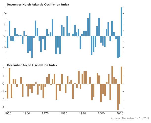
Extreme Oscillations. For some reason the AO (Arctic Oscillation) and NAO (North Atlantic Oscillation) have been trending more extreme (positive and negative values) in recent winters. Some scientists are linking these changes to a loss of Arctic sea ice, others link changes in stratospheric winds and temperatures. Why have the AO and NAO varied so much from winter to winter, switching from positive to negative? Scientists are still unsure. More on the trends in December from NASA's
Earth Observatory: "
The middle graph depicts an index of the North Atlantic Oscillation (NAO) for every December since 1950. The lower graph shows an index of the Arctic Oscillation (AO) for the same period. A third piece of the puzzle—La Niña—is shown here. The North Atlantic Oscillation is the dominant winter weather driver for eastern North America and Europe. The NAO is a ratio of shifting high and low atmospheric pressure. When NAO is strongly positive, atmospheric pressure is higher in the subtropical Atlantic (around the Azores) and lower in the North Atlantic (near Iceland). The result is usually cold and dry weather in northern Canada and Greenland, with warm and wetter weather in the Northeastern U.S."
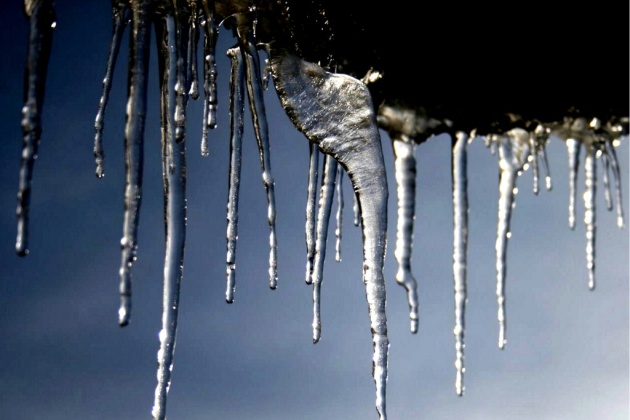
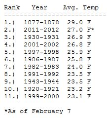
Year Without A Winter. You have to go (way) back to 1877-78 to find a similar winter to what we're experiencing now. Here are some fascinating details on that winter from the
Minnesota State Climate Office: "
The Winter of 1877-78 is the warmest Meteorological Winter on record in the Twin Cities. The winter of 1877-78 was dubbed the "Year without a Winter." Indeed, the winter of 1877-78 is the warmest winter on record for the Twin Cities with a December-February average temperature of 29 degrees. The next winter that compares is 1930-31 with an average temperature of 26.9 degrees. In 3rd place is the winter of 2001-02 with 26.8 degrees. So, how did the residents of the Twin Cities feel about their record setting warm winter in 1877-78? While residents may enjoy the ease of driving around the Twin Cities in 2012, travel was a hardship in the winter of 1877-78 for a population who depended on travel by horse and sleigh. Most roads were dirt, and the lack of snow hampered travel. Businesses were affected by the inability to move goods. Farmers near Minneapolis were plowing fields until late December 1877. But in spite of the general warmth, three days with subzero temperatures in early January 1878 froze the Mississippi River in Saint Paul so that it was closed for navigation until the 28th of February. After January 7 only three days through the remainder of the 'cool' season would experience single digit temperatures or lower." Photo credit
here.
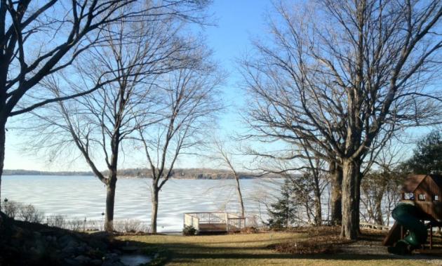
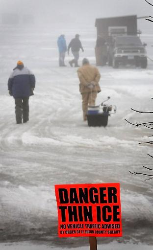
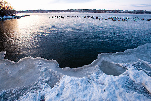
Thin Ice...In February? Details: "
Prudent anglers heed a sheriff's warning posted at the north access of Lake Washington in Le Sueur County in south-central Minnesota and walk to their fishing spot Wednesday, Feb. 1, 2012 in Manketo, Minn. In the background, other fisherman prepare to move their permanent shelter from the lake. Unseasonably mild weather has created unsafe ice conditions on many Minnesota lakes this winter. (AP Photo/Manketo Free Press, John Cross)."
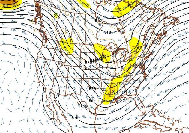
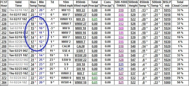
Extended Outlook: Ditto. The GFS 500mb outlook valid February 24 shows (what else?) - a west/northwest wind flow of seasonably chilly air. This pattern favors a parade of (weak) clippers, each one capable of a coating to 1" of snow (if that), but these fast-moving clippers will not be able to tap moisture from the Gulf of Mexico, limiting how much snow can fall.
Driest February In Recent Memory? We've seen a whopping "trace" of precipitation so far this month, and I still don't see any substantive moisture through February 24. The models pull chilly air into Minnesota between February 17-20, but temperatures climb into the 30s after the 21st or so (if you believe the GFS).
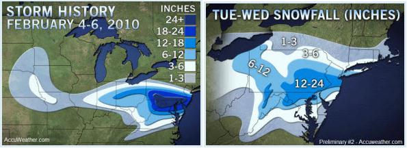
Anniversary Of The 2010 "Snowmageddon" Storms. Two years ago residents of the Mid Atlantic Region were still digging out from 1-2 feet of snow, with some 3-5 foot drifts. Details from AccuWeather's Weather Matrix and
World Weather Post: "
This week is the two-year anniversary of the “Snowmageddon” blizzard of 2010 in the mid-Atlantic, a storm which was followed by another, slightly north, only a few days later. Since we are writing a news story about the anniversary, I’ll spare you more text; each graphic is a link to different blog entries that I wrote live during the storm. It was quite something to live through!"
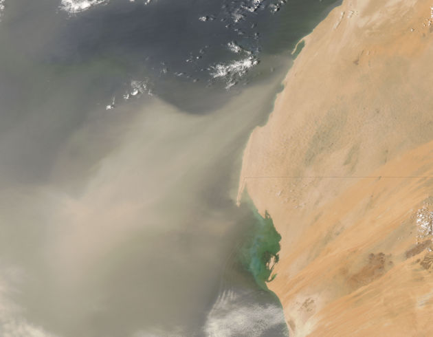
Giant Dust Cloud Chokes West Africa.
AlertNet has the story: "
A cloud of Saharan dust stretching thousands of kilometres dimmed the sun and grounded flights across the western edge of Africa, the region's worst sand storm in two years. A NASA satellite image showed a yellowish-brown plume stretching north from Western Sahara and inland to Mali. Residents of Mauritania's seaside capital Nouakchott covered their faces with scarves or stayed indoors while drivers used headlights at midday to cut through the haze as the storm, which began on Feb. 6, left thick layers of dust on sidewalks and shop windows." Satellite image courtesy of NASA.
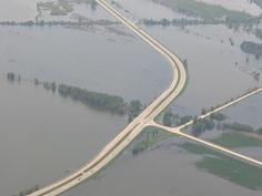
NWS Makes Changes To Flood Warning Levels. The story from
RadioIowa.com: "
The National Weather Service is changing how it measures the depths of Iowa’s waterways, which also means a change in how much water will be needed to prompt the issuing of flood warnings. Senior hydrologist, Jeff Zogg, says they’re shifting 44 of the 47 river forecast points across the state’s midsection. “The reason we’re changing the flood stages and the flood categories across central Iowa is to give our flood warnings more meaning,” Zogg says. “We want to be sure that when we issue a river flood warning for a given location, that it actually means that something is going to occur.”
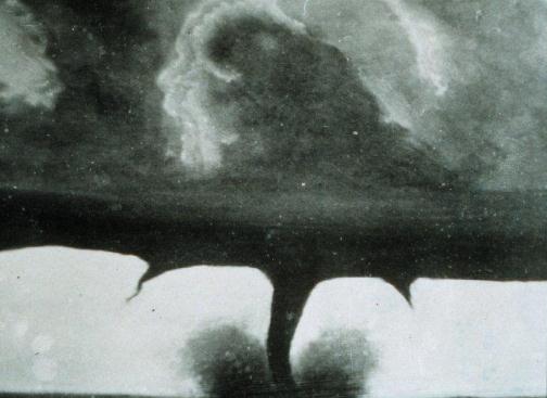
Oldest Known Photo Of A Tornado. This pic (from 1884 in South Dakota) was on the Quad Cities National Weather Service Facebook page on Wednesday. Pretty wild.
Mysterious Flash In The Sky Sparks Conspiracy Theories In Moscow. A strange, head-scratcher of a story from the U.K.
Daily Mail: "
The Russian web was ablaze with bizarre theories today at an extraordinary explosion seen by thousands of commuters in St. Petersburg. It must have seemed like the end of the world was night when motorists driving along this busy motorway saw a huge flash light up the night sky on the horizon. So far, conspiracy theories of martians and bomb-testing have emerged to explain the astonishing sight. Hower, the reality was far less exciting." Photo courtesy of RT.
KUSA Anchor Attacked By Rescue Dog During Morning Newscast.
TVSpy.com has the harrowing story: "
The heartwarming story of a local dog rescued from an icy pond on Tuesday took a turn for the worse this morning as the dog reportedly attacked KUSA morning anchor Kyle Dyer during the station’s 7 a.m. newscast. Max, an 85-pound Argentine Mastiff, fell through the ice on a pond near his home Tuesday evening and spent roughly 20 minutes stranded in the freezing water before firefighters made a dramatic rescue, which was caught on tape by KUSA’s news helicopter. After teasing Max’s visit to the KUSA studio throughout the morning, the station had him on during its 7 a.m. show, which airs on KTVD. While Max was meeting the KUSA morning team, he apparently bit Dyer on the face."
NOAA Declares Los Angeles "StormReady" and "TsunamiReady". Tsunami ready? Good grief. I'm happy to be firmly ensconced in Minnesota, where the ground underfoot is stable and earthquake-free, where I don't expect to see a tidal wave on 'Tonka or Mille Lacs anytime soon.
NOAA reports:
"On January 27, the City of Los Angeles will be recognized by NOAA’s National Weather Service as StormReady® and the largest city in the nation to become TsunamiReady™. The nationwide voluntary community preparedness programs use a grassroots approach to help communities develop plans to prepare and warn citizens about severe weather, flooding and tsunami threats. To become StormReady and TsunamiReady, the city of Los Angeles met stringent criteria focusing on both internal and external communication, alert systems, reception and understanding of hazardous weather alerts, community outreach, and a comprehensive natural disaster plan. Mark Jackson, meteorologist-in-charge of the National Weather Service forecast office in Oxnard, will present city officials with recognition letters and StormReady and TsunamiReady signs at a ceremony on January 27 during the Los Angeles City Council meeting."
15 Of The Most Popular Pictures On Pinterest. Have you checked out Pinterest yet? If you have a specific passion, like to collect certain items, enjoy scrap-booking, you may find it especially fascinating. Here's an article I stumbled upon on
LinkedIn: "If you’re like us, you’re obsessed with
Pinterest. You get excited when you find pictures you love and pin them to your online bulletin boards with a sense of pride that they are
yours. With so many photos on the two-year-old social scrapbooking site — and countless more added each day — it’s common for some to only get a handful of re-pins. Meanwhile, other images pick up so much popularity that they go virtually viral, getting pinned from one board to the next.
Future Wars May Be Waged With Mind-Controlled Weaponry, Royal Society Warns. The (fascinating) story from
gizmag.com: "
Neuroscience has ramifications for future warfare, and the scientific community must be more aware. So says a report published today by the Royal Society titled Neuroscience, conflict and security, which cites interest in neuroscience from the military community, and identifies particular technologies that may arise. Among them is the potential for "neural interface systems" (NIS) to bring about weapons controllable by the human mind, though the reports also discusses more benign military applications of neuroscience, such as fostering a revolution in prosthetic limbs."
Valentine's Day: How Much Money Will You Spend On February 14? Here's an interesting, vaguely alarming story from Coupon Cabin and
Huffington Post:
"When I was a kid, Valentine's Day meant picking out cool Scooby Doo/Jem/Power Rangers Valentine's day cards for your class (or, if you had cool parents, a little bit of D.I.Y. sparkles and construction paper). As an adult, it can mean candlelit dinners and flowers delivered to the office -- or ordering Chinese takeout while watching Revolutionary Road. However you feel about it, Valentine's Day is big business. A 2011 survey by the market research firm BIGresearch sponsored by the National Retail Federation projected that Americans would spend a total of $3.4 billion dollars on Valentine's Day dinner last year, with the average Joe (or Jane) planning on dropping $116.21 on a romantic meal."
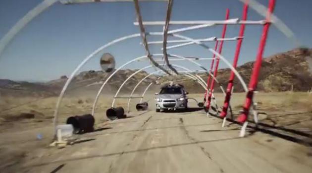
An Odd Way To Make Music. If you haven't seen this
YouTube clip it's probably worth 3 minutes of your time; a (unique) video from the musical group OK Go, called "Wanting/Needing". The way they generate some of the "music" is....um...different. Very creative...highly unusual. You just have to see the video (nearly 7 million clips). "
The new music video from OK Go, made in partnership with Chevrolet. OK Go set up over 1000 instruments over two miles of desert outside Los Angeles. A Chevy Sonic was outfitted with retractable pneumatic arms designed to play the instruments, and the band recorded this version of Needing/Getting,"
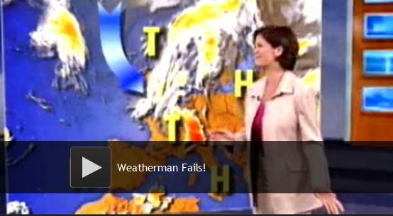
Weatherman Fails. Here's a clip of meteorological bloopers, compiled by
Huffington Post: "
The weather is rarely the most interesting part of a newscast, especially when it's just another sunny day. But when weathermen and women chuckle uncontrollably, fart, rap, swear, become WAY too excited by snow accumulation or commit some other form of FAIL, then you've got some genuine entertainment."
"
Today I bent the truth to be kind, and I have no regret, for I am far surer of what is kind than I am of what is true." Robert Brault.
www.robertbrault.com.
Paul's Conservation Minnesota Outlook for the Twin Cities and all of Minnesota:
TODAY: Mild sun, no complaints. Winds: SW 10-15. High: near 40
THURSDAY NIGHT: Clouds increase, turning sharply colder. Low: 8
FRIDAY: Sunny, biting wind. Feels like -10. High: 14
SATURDAY: Blue sky. Numbing breeze. Subzero start in the suburbs. Low: 0 (KMSP International). High: 15
SUNDAY: Fading sun, not as cold. PM temperatures closer to average for mid February. Low: 6. High: 27
MONDAY: Coating of slush? Mostly wet roads. Low: 18. High: 31
TUESDAY: Drier day. Milder than average. Low: 23. High: 35
WEDNESDAY: Flurries. Possible drizzle or freezing drizzle. Damp. Low: 25. High: 33
Snow Optional
We are in uncharted waters. I'm getting a nosebleed listening to some of the theories about why North America's weather pattern has become STUCK in a mild, dry, largely snow-free regime. Is it all La Nina? Are changes in the Arctic (melting ice) having a domino effect? Stratospheric warming? A symptom of climate change? I don't pretend to know.
But the longer this drags out - the more I'm reminded of the (sad, sorry) "Winter" of 1986-87, when only 17.4" snow fell. 7 winter since 1986 have brought less than 40". Last winter may have been the exception, not the rule.
We're in a growing drought; between that and La Nina locking in a mostly-Pacific wind flow aloft, storms can't tap moisture from the Gulf. A surge of truly bitter air would buckle the jet stream, spewing a firehose of moisture into Minnesota, but I still don't see this scenario playing out through the end of February.
14.9 inches has fallen. With La Nina and the drought total snowfall may be under 25 inches. I hope I'm wrong; we need the moisture.
40 today gives way to the coldest weather of February; not as numbing as January, but parka-worthy by Saturday. A snowy coating is possible on Monday.
Woo-hoo!
"The past can't see you, but the future is listening." - Terri Guillemets
Climate Stories....
Global Warming: Like Weather On Steroids. A warmer atmosphere holds more water vapor. Worldwide, the amount of water in the air has increased by roughly 4%, which doesn't sound like much, but it is. More water means storms have the capacity to be more severe, with heavier rainfall/snowfall amounts, with a greater potential for flooding, something we're seeing in the data.
Yahoo News has the story: "
Are we "doping" our atmosphere? What's going on with these record warm temperatures… extreme snowfall… even January tornadoes? Is climate change the cause? Or more appropriately, what impact is climate change having on our weather? To help answer those questions, a group of researchers has just released a new online guide for understanding the links between more extreme weather and a warming planet. Is global warming throwing our weather out of whack? Scientists tell us there's no easy, blanket answer. The bottom line is that the evidence can be strong or weak, depending on the type of weather. That, admit researchers, can be confusing to anyone looking for a clear answer."
Weather On Steroids? Continuing the theme, why are extreme weather events on the increase, worldwide? Climate change may be injecting more energy into the system (jet stream winds have been blowing 10-20% faster than average this winter). When ild westerly winds do buckle the results can be even more extreme, spinning up record snowfalls, pulling bitter air unusually far south. Here's an explanation and video clip from
Climate Central: "
It's not easy to explain the relationship between extreme weather events, such as a record heat wave, and global climate change. Although emissions of greenhouse gases are making heat waves more common and more severe overall, you can't say that a specific event is due to global warming. This is where a helpful baseball analogy comes in. In this video from the National Center for Atmospheric Research in Boulder, Colo., researcher Jerry Meehl explains how greenhouse gases have a similar impact to steroids in a baseball player, which increase the chances of hitting a home run, but don't guarantee that each home run was caused by steroid use."
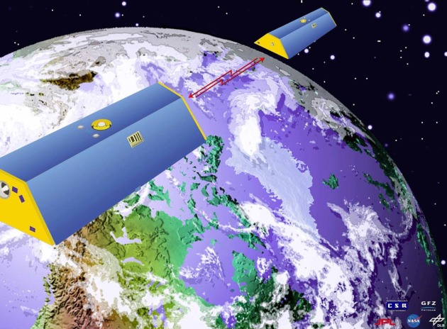
NASA Mission Takes Stock Of Earth's Melting Land Ice. A press release from
NASA: "
WASHINGTON -- In the first comprehensive satellite study of its kind, a University of Colorado at Boulder-led team used NASA data to calculate how much Earth's melting land ice is adding to global sea level rise. Using satellite measurements from the NASA/German Aerospace Center Gravity Recovery and Climate Experiment (GRACE), the researchers measured ice loss in all of Earth's land ice between 2003 and 2010, with particular emphasis on glaciers and ice caps outside of Greenland and Antarctica. The total global ice mass lost from Greenland, Antarctica and Earth's glaciers and ice caps during the study period was about 4.3 trillion tons (1,000 cubic miles), adding about 0.5 inches (12 millimeters) to global sea level. That's enough ice to cover the United States 1.5 feet (0.5 meters) deep." Photo courtesy of NASA.
Why The Energy Industry Is So Invested In Climate Change Denial. Here's an Op-Ed from Bill McKibbon in
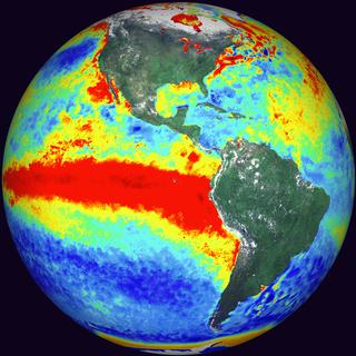
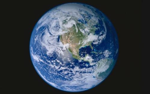
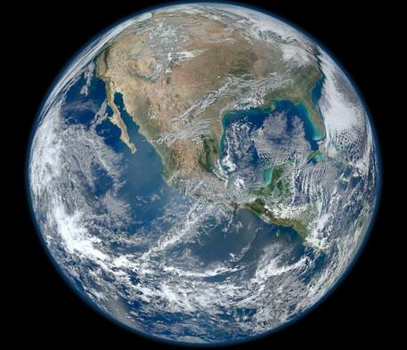
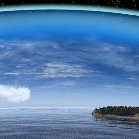
The Guardian: "If we could see the world with a particularly illuminating set of spectacles, one of its most prominent features at the moment would be a giant carbon bubble, whose bursting someday will make the housing bubble of 2007 look like a lark. As yet – as we shall see – it's unfortunately largely invisible to us. In compensation, though, we have some truly beautiful images made possible by new technology. Last month, for instance, Nasa updated the most iconic photograph in our civilization's gallery: "Blue Marble", originally taken from Apollo 17 in 1972. The spectacular new
high-def image shows a picture of the Americas on 4 January, a good day for snapping photos because there weren't many clouds."
Photo above of
Earth on January 4, 2012 courtesy of NASA, flickr.com and The Guardian.
 Global Warming: Politics Overwhelm The Science
. The story from the
Summit County Citizens Voice: "SUMMIT COUNTY — The science of climate change may be based on a widespread consensus, but that is not reflected by the political realities in Washington, where the issue has polarized Democrats and Republicans along party lines. And that schism has led to an erosion of public belief that global warming is a threat human health and welfare. Public acceptance of the climate change threat was greatest in 2006-2007, when there was broad agreement among lawmakers on the issue, according to Ohio State University professor J. Craig Jenkins,
who recently co-authored a study on public climate change perceptions. Since those years of bipartisan agreement, public concern has dropped." Photo: patriotpost.us.
Popular Opinion On Climate Change Traced To Political Elites. I did a double-take when I saw this headline, but it comes from
Scientific American, so I gave it another look. Here's an excerpt:
"It seems the general public just can't make up its mind about the existence of man-made climate change. Rather than steadily increasing or decreasing over the last decade, the U.S. public's concern over our warming planet has jumped up and down, according to Gallup polls. But what exactly is driving this seesawing of opinions on climate change? The level of public concern about this global issue is mostly influenced by the mobilization efforts of political leaders and advocacy groups, new research shows. "Public opinion regarding climate change is likely to remain divided as long as the political elites send out conflicting messages on this issue," lead researcher Robert Brulle, a professor of sociology and environmental science at Drexel University in Philadelphia, said in a statement."
Photo credit above: "
Even after decades of research, some scientists, policymakers and members of the U.S. general public still fail to focus on climate change as a problem to address. Image: Nicolle Rager Fuller, National Science Foundation."


No comments:
Post a Comment