Todd's Conservation MN Outlook for the Twin Cities and all of Minnesota:
FRIDAY: Mostly cloudy with light snow, light coating in northern Minnesota. Breezy. Feels like February again. Winds: NW 10-20mph. High: 29
FRIDAY NIGHT: Flurries continue early, then partial clearing late. Winds die down late. Winds: NW 5-15mph. Low: 13
SATURDAY: A chilly and somewhat sunny start, clouds thicken through the day. Turning breezy. Winds: ESE 10-15mph. High: 28.
SUNDAY: Storm system blows in. Looks like a northerly track, which would keep the heavy snow (6"+) across far northern Minnesota. We get a rain/snow mix... NOTE: Forecast likely to change as storm nears!! Winds: E 10-20mph turning WSW 10-20 later. Low: 21. High: 35.
MONDAY: Flurries and partial clearing. Another system looks to be developing and heading up from the southwest. Another chance of snow late. Low: 18. High: 28.
TUESDAY: Cloudy, chance of snow. Low: 12. High: 24.
WEDNESDAY: Snow chance lingers. Low: 18. High: 30.
THURSDAY: Partly cloudy and quiet for a change. Low: 18. High: 32
Funny Traffic Cam
This is a funny image from NEBRASKAlandMagazine.com
It almost looks like this bird is getting ready to do a live traffic report!

Springing to Life in New York
Temperature have been so warm across parts of the nation this January and February that nature is being fooled into springing into action a little earlier than normal. The picture below comes from the National Weather Service in Bighamton, NY's Facebook Page.

Northwestern Winter Storm Winds Down
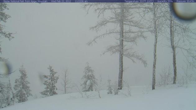
After days of heavy rain, snow and wind, the Pacific Northwest is calming down a bit today. The skies have cleared in a few locations to reveal the newly fallen snow. Snow reports of up to 3ft., wind reports of up to 113mph (equivalent to a category 3 hurricane) and several avalanches have resulted from this latest event. The image below is from Glacier National Park in Montana, yesterday it looked quite snowy!
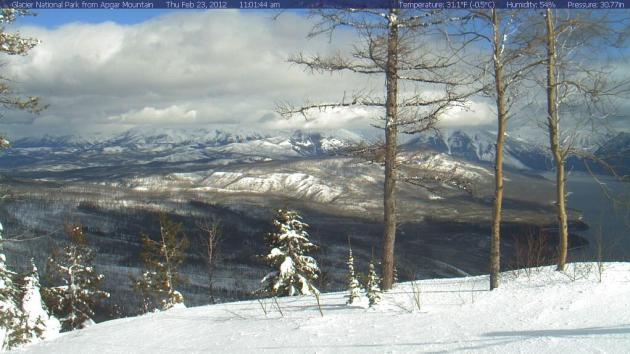
This was the view on Wednesday, see more webcams here
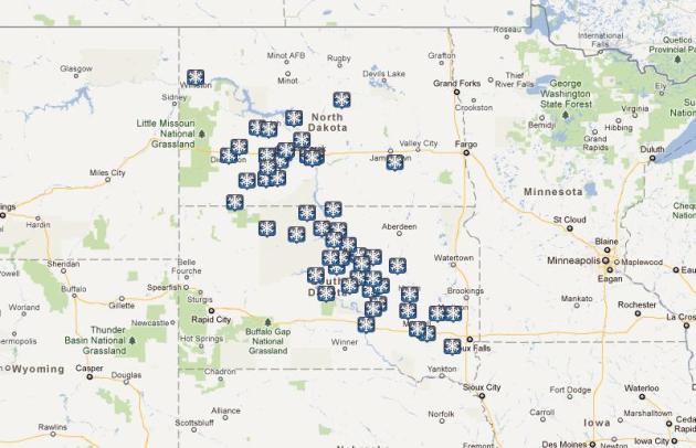
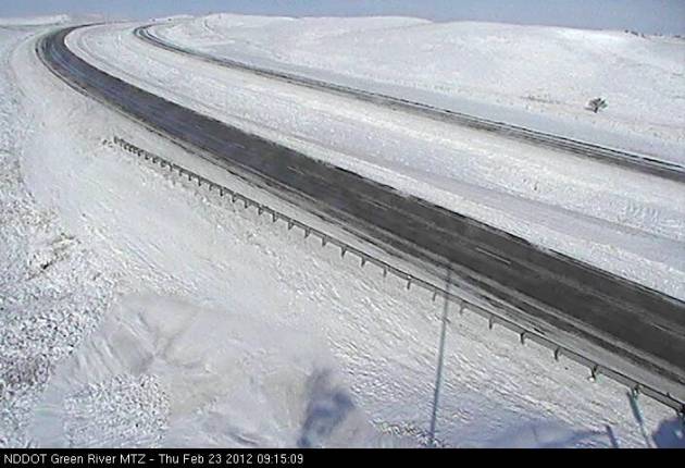
Snow Reports From the Clipper That Sailed West and South of the Twin Cities
This clipper brought quite a bit of snow to a few locations, interestingly it was in a very thin narrow band. 14″ is the highest I’ve seen near Carson in North Dakota.
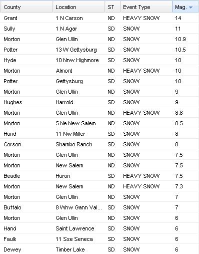
Note how thing the band of snowfall reports are. This was a very small, but intense snowband that made travel very hazardous if you were within
Road Closures Earlier Today
I-94 westbound from Mandan to Dickinson was closed for a time earlier today due to heavy snow and blowing snow.
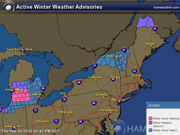
Chicago and Detroit Gearing Up For Snow Now!
Chicago is under a Winter Weather Advisory through Friday, take a look at other locations that have winter weather headlines.
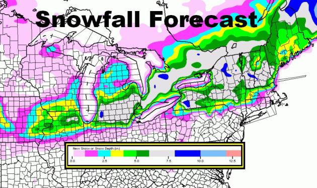
Northeast Snowfall Forecast
Take a look at the 48hour snowfall forecast. The fast moving clipper will run through Chicago, Detroit and other locations in the Northeast with more heavy snow. A few locations here could also see 6″ to 10″ or more
Looking Ahead... Rumors About A Weekend Storm Close to Home
Yes, there have been rumors about the potential for a weekend storm across Minnesota and models are still picking up on the chance of accumulating snow for Sunday into Monday. Hard to say what the exact details would be at this point, but it is looking like the center of the storm would pass over the Twin Cities and central Minnesota (if current forecasts verify). Here are a few different looks at the storm from different weather models.
ECMWF European Model
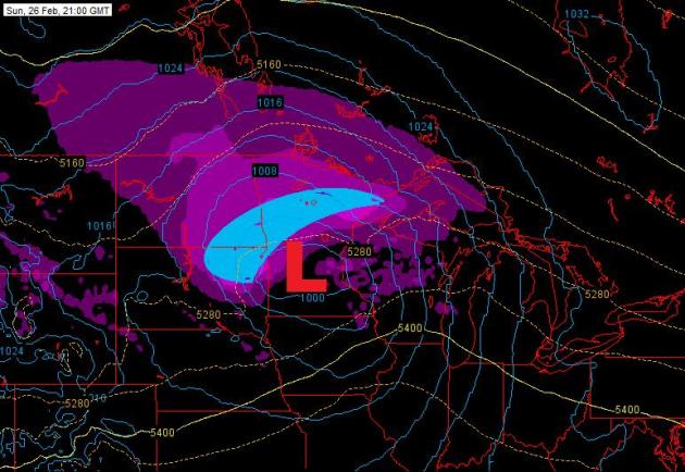
This one has been doing pretty good lately and I would tend to trust this one a little more. With that said, the ECMWF shows the center of the storm tracking over central Minnesota by Sunday afternoon. If that is the case, that would cut down the snow totals for the southern half of the state, in fact, there could even be a little rain. The heaviest snow would set up through northern Minnesota and the eastern portions of North and South Dakota, which I've highlighted in blue.
GFS Model
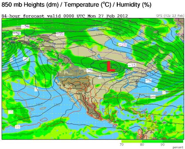
This too shows the center of the storm passing over central Minnesota and possibly even a little farther north, which again would put the heaviest snow across northern Minnesota. The Twin Cities here would have significantly less snow and possibly even see a little rain.
NAM Solution
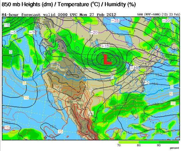
The Sunday/Monday solutions are just starting to show up in the extended periods as this models only goes out 84hrs. The NAM is following the other solutions with the center of the storm over central Minnesota, keeping the heaviest snow north and the lighter amounts of snow near the Twin Cities, possibly even mixing in with rain.
Thanks for checking in, have a great rest of the week and don't foget to follow me on Twitter @TNelsonWNTV

-Meteorologist Todd Nelson-
No comments:
Post a Comment